Appendix
Preliminary Site Plan - View Royal Fire Hall
March 12, 2013Page 1222 sections
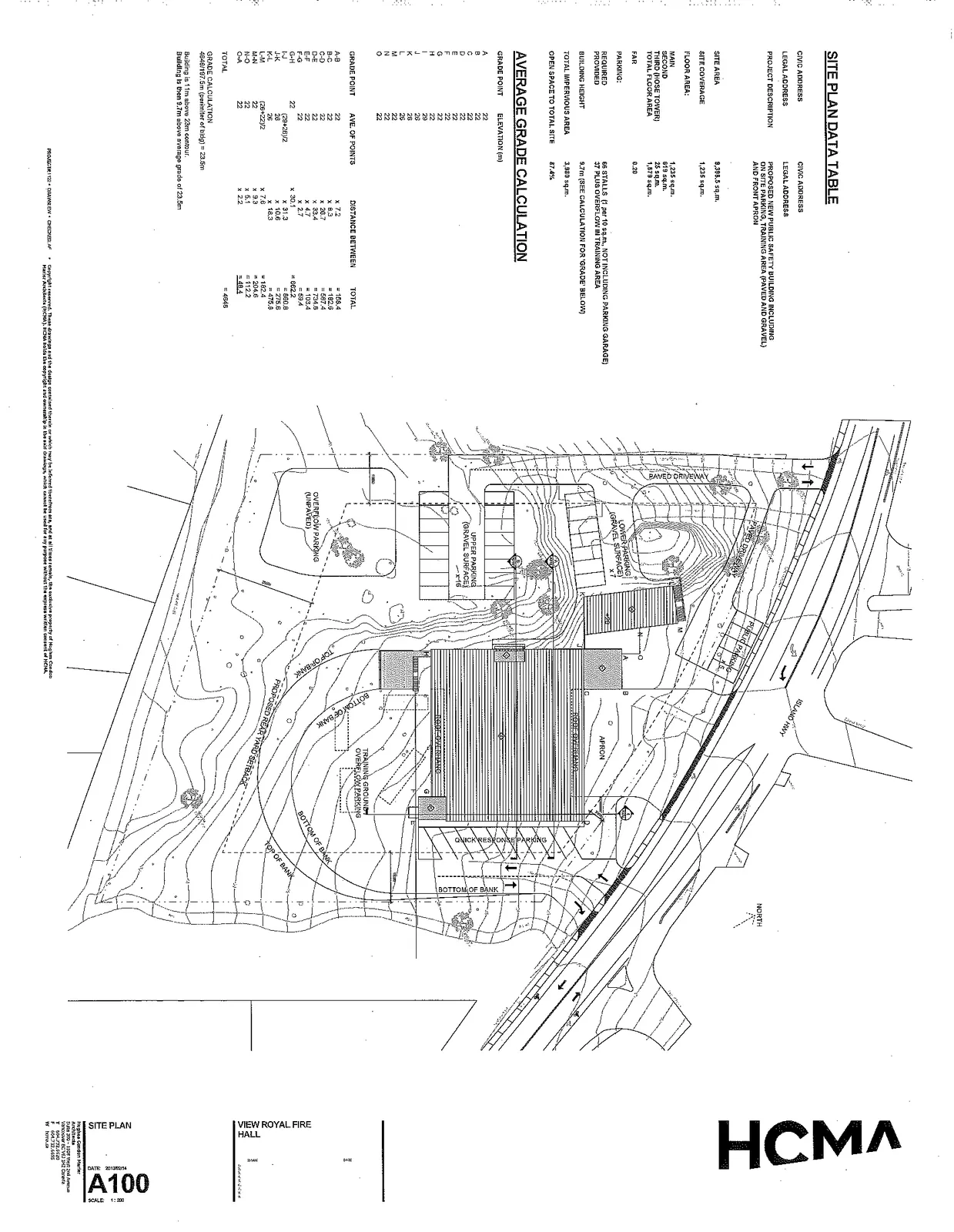
Technical drawing showing the proposed layout and grading for the new public safety facility at 329-337 Island Highway.
Drawn by HCMA architectsTotal Floor Area: 1,319 sq.m.Identifies upper and lower parking areas and training grounds
SITE PLAN DATA TABLE
| CIVIC ADDRESS | |
| LEGAL ADDRESS | |
| PROJECT DESCRIPTION | PROPOSED NEW PUBLIC SAFETY BUILDING INCLUDING ON SITE PARKING, TRAINING AREA (PAVED AND GRAVEL) AND FRONT APRON |
| SITE AREA | 9,395.3 sq.m. |
| SITE COVERAGE | 1,235 sq.m. |
| FLOOR AREA: | |
| MAIN | 1,235 sq.m. |
| SECOND | 519 sq.m. |
| THIRD (HOSE TOWER) | 25 sq.m. |
| TOTAL FLOOR AREA | 1,879 sq.m. |
| F.A.R. | 0.20 |
| PARKING: | |
| REQUIRED | 66 STALLS (1 per 10 sq.m., NOT INCLUDING PARKING GARAGE) |
| PROVIDED | 37 PLUS OVERFLOW IN TRAINING AREA |
| BUILDING HEIGHT | 9.7m (SEE CALCULATION FOR 'GRADE' BELOW) |
| TOTAL IMPERVIOUS AREA | 3,889 sq.m. |
| OPEN SPACE TO TOTAL SITE | 87.8% |
Page 122
AVERAGE GRADE CALCULATION
| GRADE POINT | ELEVATION (m) |
|---|---|
| A | 22 |
| B | 22 |
| C | 22 |
| D | 22 |
| E | 22 |
| F | 22 |
| G | 22 |
| H | 22 |
| I | 26 |
| J | 28 |
| K | 28 |
| L | 26 |
| M | 22 |
| N | 22 |
| O | 22 |
| GRADE POINT | AVE. OF POINTS | DISTANCE BETWEEN | TOTAL |
|---|---|---|---|
| A-B | 22 | x 7.2 | = 158.4 |
| B-C | 22 | x 8.3 | = 182.6 |
| C-D | 22 | x 26.7 | = 587.4 |
| D-E | 22 | x 33.4 | = 734.8 |
| E-F | 22 | x 8.7 | = 191.4 |
| F-G | 22 | x 3.1 | = 68.2 |
| G-H | 22 | x 30.1 | = 662.2 |
| H-I | (22+26)/2 | x 10.6 | = 254.4 |
| I-J | 27 | x 10.2 | = 275.4 |
| J-K | 28 | x 31.3 | = 876.4 |
| K-L | (28+26)/2 | x 17.6 | = 475.2 |
| L-M | 24 | x 7.9 | = 189.6 |
| M-N | 22 | x 9.3 | = 204.6 |
| N-O | 22 | x 5.1 | = 112.2 |
| O-A | 22 | x 3.2 | = 70.4 |
| TOTAL | = 4545 |
GRADE CALCULATION 4545 / 197.6m (perimeter of bldg) = 23.0m
Building is 11.7m above 23m contour. Building is then 9.7m above average grade of 23.0m
VIEW ROYAL FIRE HALL SITE PLAN
DATE: 2012/02/14 A100 SCALE: 1:300
Page 122
Extracted from: 2013 03 12 Committee of the Whole Agenda