Project Summary N-089: Coastal Adaptation Plan
Phase 2 of a plan to address coastal flooding risks from sea level rise and extreme weather.
Project Summary
Priority: Strategic Public Engagement: Involve Project Name: Coastal Adaptation Plan 1-2-05100-615 CC510-28 Submitted by: Jeff Chow, Senior Planner Director: Leanne Taylor, Development Services
Executive Summary
This project implements Goal 3c from the 2023-2026 Strategic Plan, a climate action and environmental stewardship initiative to undertake coastal flood mapping as Phase 1 in an overall plan to develop a sea-level rise and storm surge mitigation and adaptation policy. The Town was awarded $95,000 from the 2023 Spring BC Community Emergency Preparedness Fund Disaster Risk Reduction-Climate Adaptation grant to carry out Phase 1 (data collection and mapping) of a Coastal Adaptation Plan. This project summary carries forward with a modified budget for consulting work to complete the plan. Phase 2 of the project would use information from Phase 1 to develop a plan to inform decisions on coastal flooding risks, future development, and asset management in order to enhance community resiliency, emergency planning, and safeguard Town infrastructure.
Business problem and opportunity
The Hazard Risk Vulnerability Analysis (HRVA) and the BC Flood Hazard Area Land Use Management Guidelines acknowledge flood risks from sea level rise, tsunamis, and extreme weather events. Phase 1 of the Coastal Adaptation Plan began in 2024 and is anticipated to be completed in 2025 (FY1). Phase 2 would use the data from Phase 1 to conduct public and stakeholder engagement as part of developing a plan to address coastal flooding risks. Part of the work for Phase 2 has begun through a $330k grant-funded joint project of the Town and the other three municipalities along the Gorge Waterway. As part of Phase 2, the Town could seek funding for a similar project for Esquimalt Harbour either alone or jointly with other municipalities and First Nations for economies of scale and increased potential for a successful grant application.
Proposed project objectives
- Phase 1: complete modelling and mapping that is underway and funded by a grant (2025)
- Phase 2: Carry out public engagement and plan development (FY2-FY3, subject to grant funding)
Business risks
Without a comprehensive plan to address coastal flooding there could be risks of personal harm, damage to private development and the Town’s infrastructure (e.g., roads, parks, pump stations and bridges), and challenges for emergency planning.
Proposed sources of funding
FY2-FY3: Once Phase 1 is completed, grants can be sought for Phase 2 (any approved grant funding would reduce the use of Casino revenue) 1-1-00557-866
Costs and benefits
| Costs | FY1 | FY2 | FY3 | FY4 | FY5 | 5-year Total |
|---|---|---|---|---|---|---|
| Capital | 0 | 0 | 0 | 0 | 0 | 0 |
| Operational | 0 | 100,000 | 100,000 | 0 | 0 | 200,000 |
| Total | 0 | 100,000 | 100,000 | 0 | 0 | 200,000 |
Benefits
| Type | Description |
|---|---|
| Tangible | Identified extent of risks to public and private property/infrastructure. |
| Intangible | Plan for long term community resiliency to coastal flood hazards. Policies and updated information for emergency planning, asset management, capital planning, and land development. |
Recommendation
THAT the Committee recommend the 2026-2030 Financial Plan include a Coastal Adaptation Plan in 2027-2028 to be funded by Casino revenue.
Additional Information
- Considerations for coastal flood planning: a. BC Flood Hazard Area Land Use Management Guidelines - 2018 Amendment (see Sections 3.5 and 3.6) https://www2.gov.bc.ca/assets/gov/environment/air-land-water/water/integrated-flood-hazard-mgmt/flood_hazard_area_land_use_guidelines_2017.pdf
- Example of study result and analysis for Phase 1: May 2021 City of Colwood – Coastal Flood Inundation Mapping and Tsunami Risk Assessment (162 pages) https://colwood.civicweb.net/FileStorage/EDE7F0DF3B2C4484B27004681AF4B96D-USE%20THIS%20ONE.pdf
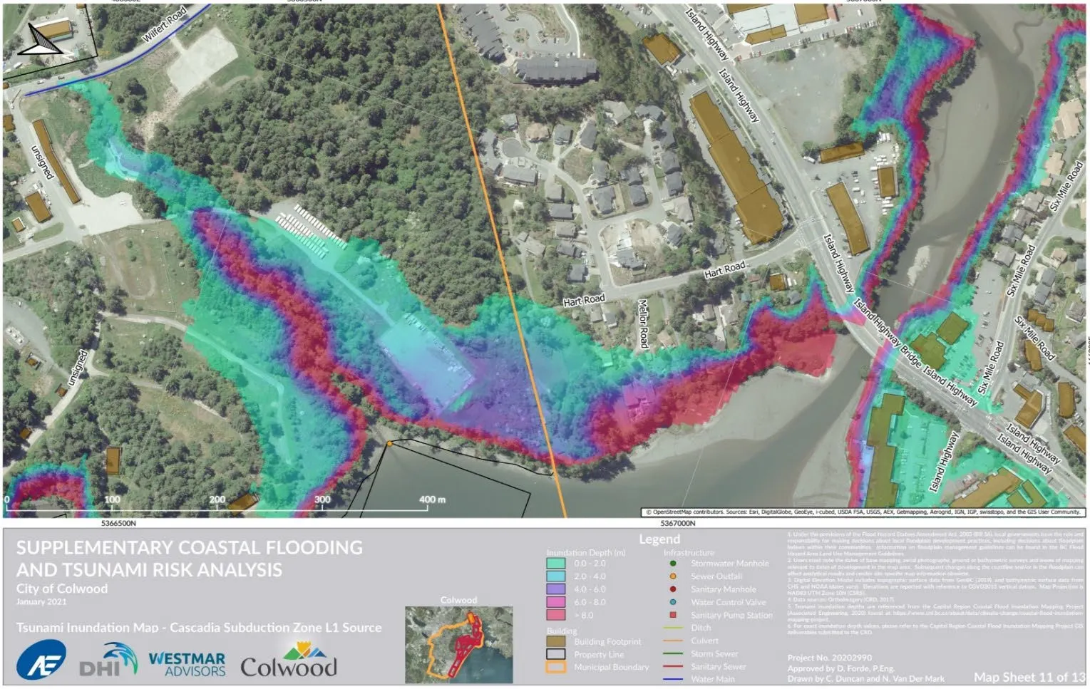
Excerpt: Heat map of potential inundation of Esqumalt Harbour at View Royal border – Millstream Estuary and Parsons Bridge
- Example of a plan to protect specific municipal infrastructure: July 2016 City of Colwood Pump Station Relocation Plan RFP - https://www.colwood.ca/sites/default/files/RFP/RFP-2016-03%20Ocean%20Blvd%20Pump%20Station%20Relocation%20Plan.pdf
- 2009 Community Risk Assessment https://www.viewroyal.ca/assets/Town~Hall/Documents-Forms/Administration/2009%2005%2031%20TOVR%20Community%20Risk%20Assessment.pdf
- Example of tsunami-resistant building design guidelines https://www.fema.gov/sites/default/files/2020-08/fema_earthquakes_guidelines-for-design-of-structures-for-vertical-evacuation-from-tsunamis-fema-p-646.pdf