Official Community Plan Update: Review of Draft Western Gateway Corridor Scenario (Presentation Slides)
Facilitator presentation slides used during the workshop to guide Council's review of the Draft Western Gateway Corridor Scenario and collect feedback on land use, transportation, and environment.
Official Community Plan Update
Review of Draft Western Gateway Corridor Scenario
Special Council Meeting – February 24, 2026
Council Motion
At the February 17, 2026, Council Meeting, Council ratified the following motion:
THAT the Committee recommend to Council that a Special Council meeting be held to gather Council’s input on the Western Gateway Corridor prior to the preparation of a draft Official Community Plan (OCP);
AND THAT the OCP Advisory Committee be invited to attend the meeting;
AND FURTHER THAT the meeting include a facilitated workshop at a cost not to exceed $5,000.
Purpose of Discussion
Provide Council with an opportunity to review and provide input on the proposed Western Gateway Corridor to inform the first draft of the Official Community Plan.
Objectives of Technical Presentation
- Provide an overview of the 2011 OCP land use designation.
- Present the proposed land use designations for the Western Gateway Corridor, including uses, heights and densities, and associated map changes.
- Identify key differences between the 2011 OCP and the proposed plan.
- Provide additional technical detail on land use and density, transportation and environmental protection.
What we are looking for from Council tonight
- What elements of the proposal feel supportable?
- Where do you have concerns or hesitation?
- Are there any issues you feel require more analysis or consideration?
Specific direction on Western Gateway Corridor scenario must be brought forward as a Council motion, following discussion.
Outcomes from Tonight's Discussion
- Facilitator summary report
- Revised Western Gateway Corridor scenario as per Council’s motion
Spirit of Engagement
- Welcome a diversity of perspective
- Stay curious, not judgmental
- Honour our time together
- Build upon each other's ideas
- Aim for direction, not perfection
OCP Background and Context
- An Official Community Plan (OCP) is a bylaw that is a reflection of community values and guides decisions on land use, housing, transportation, parks, environmental stewardship, economic development, etc.
- An OCP must contain statements and map designations to meet 20-year housing needs, along with an outline of present and proposed land uses, greenhouse gas targets, and more.
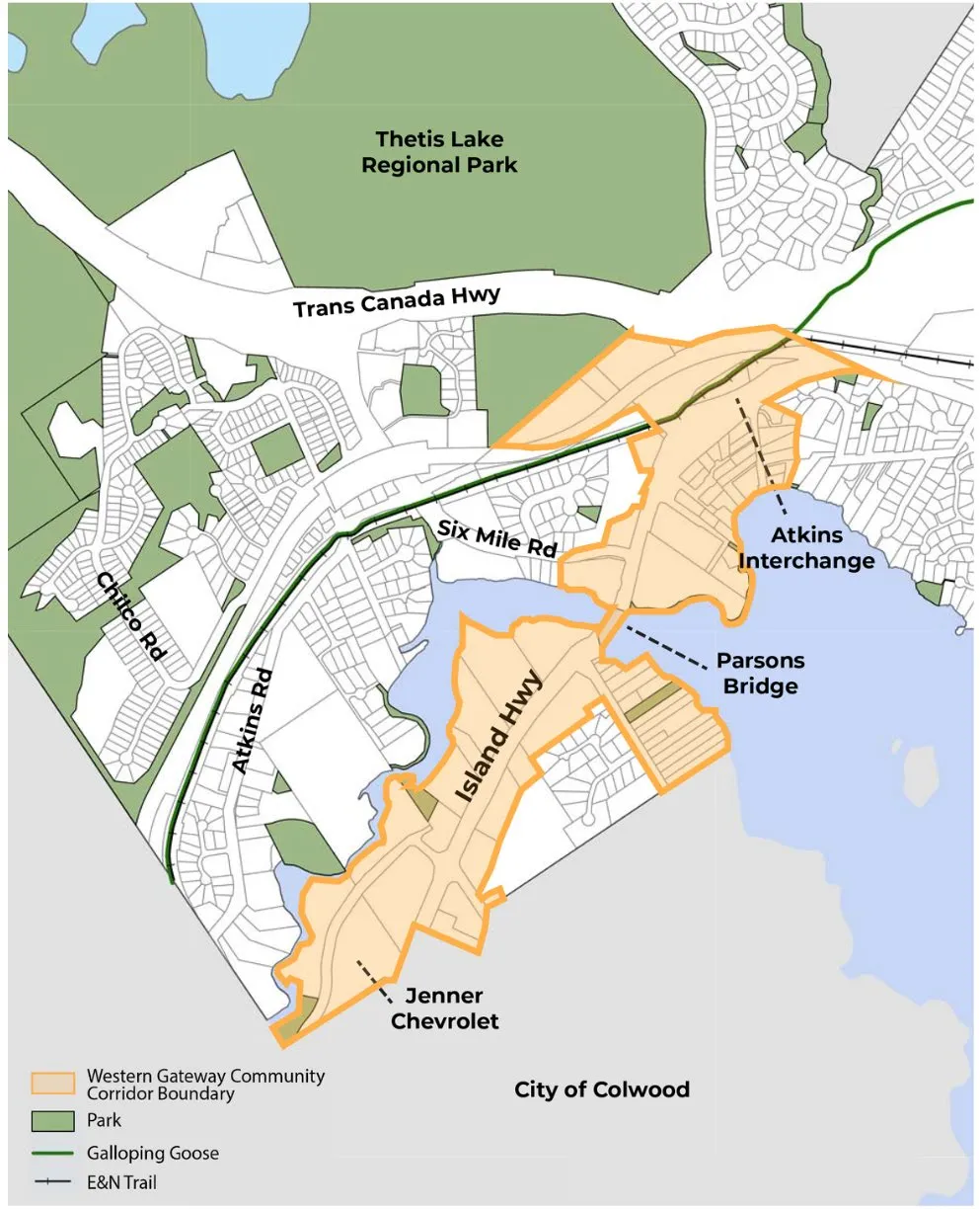
OCP Western Gateway Corridor
Council expressed an interest in exploring the Western Gateway further as part of the OCP review and update, during the June 10, 2025, Council meeting.
Desired outcomes:
- Explore the potential for this area to become an employment hub.
- Consider a mix of commercial, tourist accommodation, some light industrial, and residential uses.
Engagement on Western Gateway Corridor
Vision and Guiding Principles Survey: January 24 – February 18, 2025
- Completion of broad value and vision questions, plus a mapping exercise.
Business Mixer Workshop: March 6, 2025
- Explore the opportunities and challenges for business growth in View Royal.
Community Growth Survey: March 7 – April 4, 2025
- Explore interest and supportability of density and growth in existing corridors and neighbourhood centres, as well as land use (commercial and industrial vs residential) interest in the Western Gateway.
Western Gateway Corridor Engagement: October 7 – November 21, 2025
- Explored broad visioning questions and priority improvement areas, along with three land use scenarios.
- Western Gateway Corridor Survey - October 7 – November 21, 2025
- Community Workshop - October 18, 2025
- Open Houses - October 18 and 22, 2025
- Focus Group: Business & Landowner Workshop – October 21, 2025
Western Gateway Scenarios Review (October 7 – November 21 Engagement)
Scenario 1: High Growth
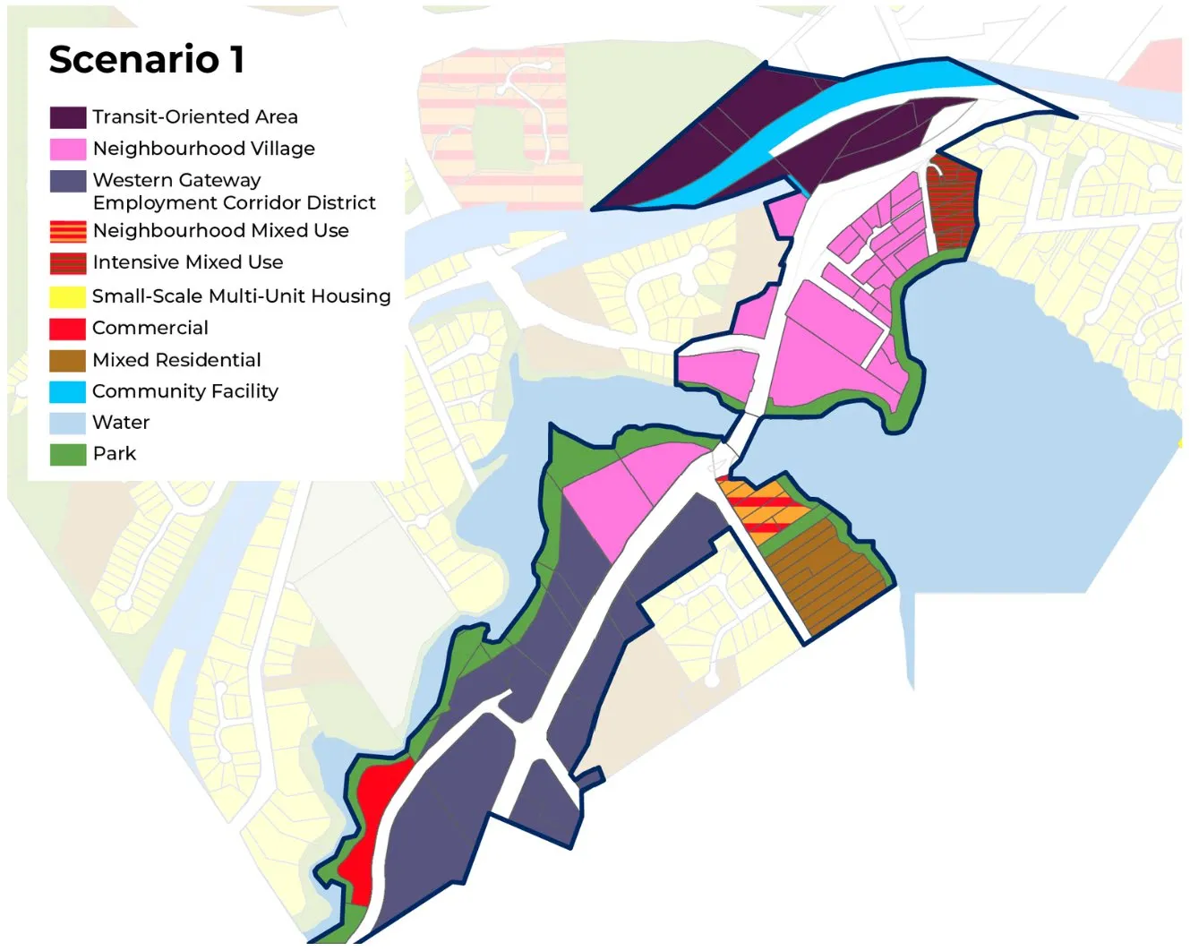
Potential Growth and Development:*
- Residential Units: 2,200 [up to 5,375]
- Population: 5,100 [up to 12,300]
- Commercial Floor Area: 238,500 m2
- Light Industrial Floor Area: 160,400 m2
Analysis Assumptions* The potential growth scenario assumes that each parcel will be redeveloped and will be built to the maximum potential density. In addition, the scenarios do not consider on-site constraints, such as site and soil conditions, environmental setbacks, or permit requirements.
Scenario 2: Medium Growth
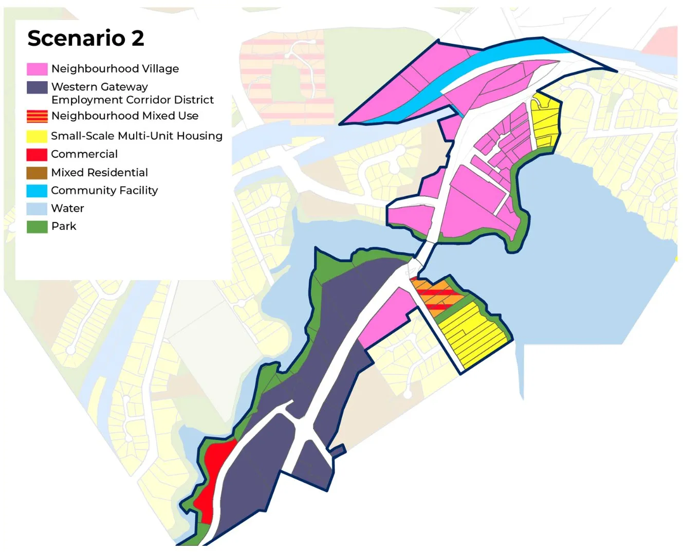
Potential Growth and Development:*
- Residential Units: 1,700 [up to 3,800]
- Population: 3,900 [up to 8,700]
- Commercial Floor Area: 204,000 m2
- Light Industrial Floor Area: 155,000 m2
Analysis Assumptions* The potential growth scenario assumes that each parcel will be redeveloped and will be built to the maximum potential density. In addition, the scenarios do not consider on-site constraints, such as site and soil conditions, environmental setbacks, or permit requirements.
Scenario 3: Low Growth (Existing 2011 OCP)
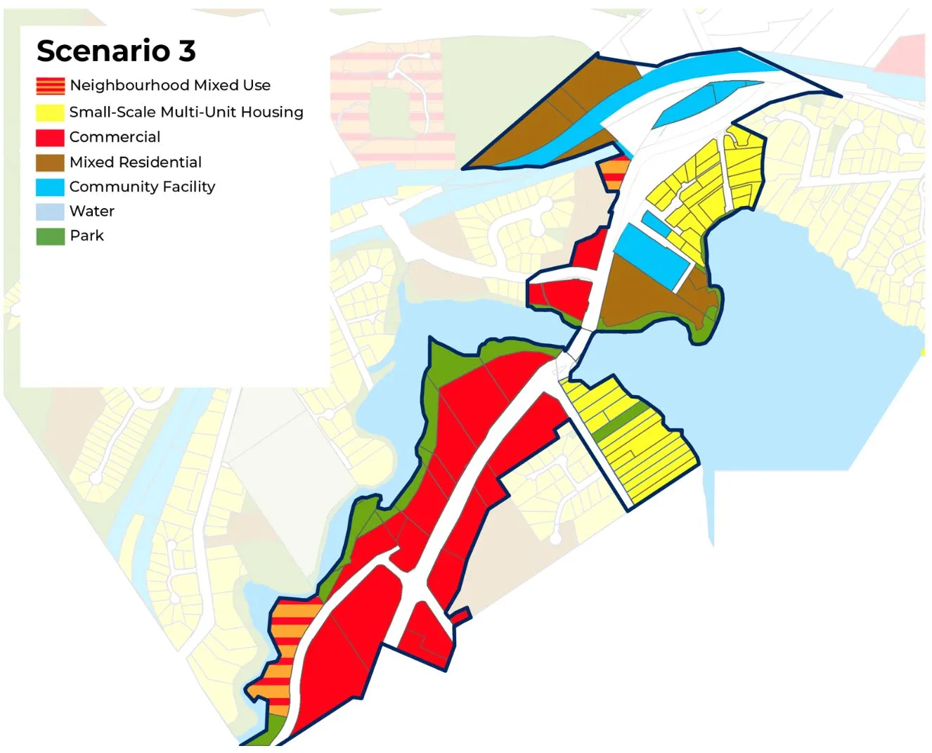
Potential Growth and Development:*
- Residential Units: 1,400 [up to 2,200]
- Population: 3,300 [up to 5,075]
- Commercial Floor Area: 311,000 m2
- Light Industrial Floor Area: 0 m2
Analysis Assumptions* The potential growth scenario assumes that each parcel will be redeveloped and will be built to the maximum potential density. In addition, the scenarios do not consider on-site constraints, such as site and soil conditions, environmental setbacks, or permit requirements.
Preferred Scenario: Engagement Feedback
- 100 total responses were provided to indicate the preferred scenario.
- 39% of respondents preferred Scenario 2 (Medium Growth)
- 27% of respondents preferred Scenario 1 (High Growth)
- 17% of respondents preferred a hybrid of scenarios.
- 14% of respondents preferred Scenario 3 (Low Growth – 2011 OCP land uses)
2011 OCP Land Use Map
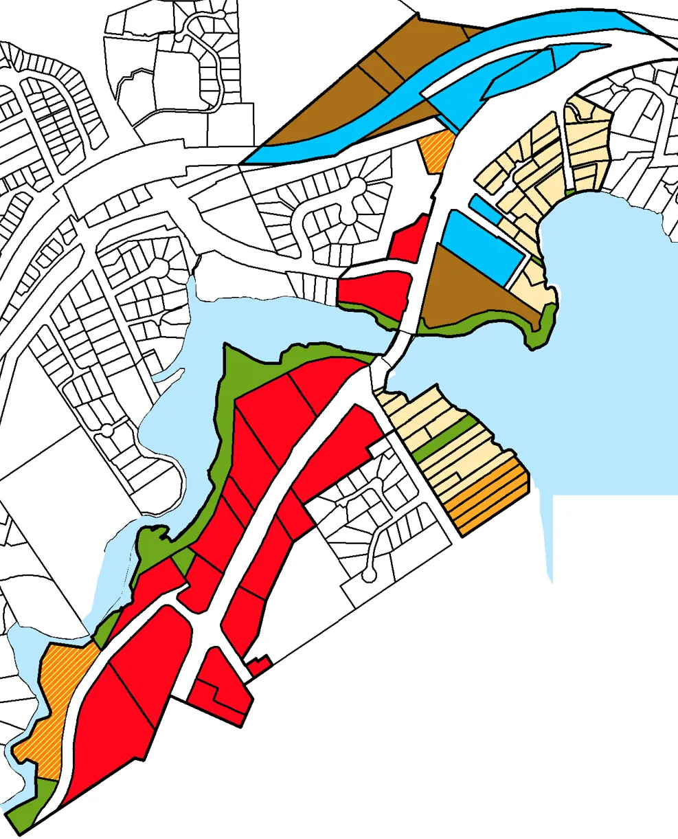
Potential Land Use Capacity:*
- Total Retail Area: 311,000 m2
- Total Industrial Area: 0 m2
- Total Residential Area: 132,000 m2
- Total Residential Units: 2,200
- Total Population: 5,075
Analysis Assumptions* The potential growth scenario assumes that each parcel will be redeveloped and will be built to the maximum potential density. In addition, the scenarios do not consider on-site constraints, such as site and soil conditions, environmental setbacks, or permit requirements.
Proposed Land Use Map
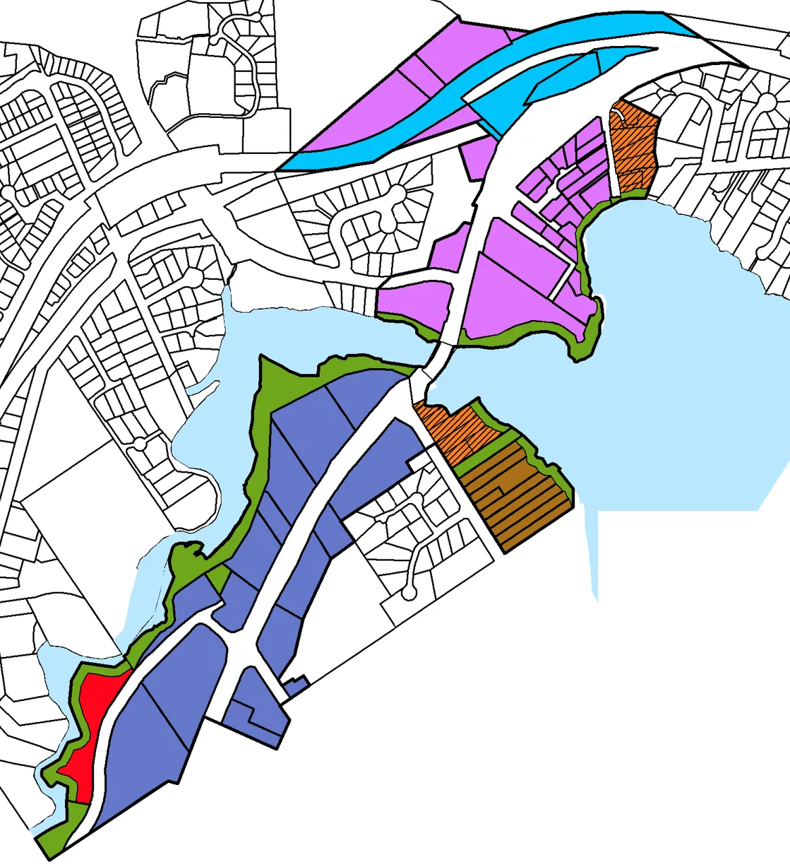
Potential Land Use Capacity:*
- Total Retail Area: 225,000 m2
- Total Industrial Area: 152,000 m2
- Total Residential Area: 259,000 m2
- Total Residential Units: 4,480
- Total Population: 10,310
Analysis Assumptions* The potential growth scenario assumes that each parcel will be redeveloped and will be built to the maximum potential density. In addition, the scenarios do not consider on-site constraints, such as site and soil conditions, environmental setbacks, or permit requirements.
Existing 2011 OCP Land Uses vs Proposed First Draft OCP Land Uses
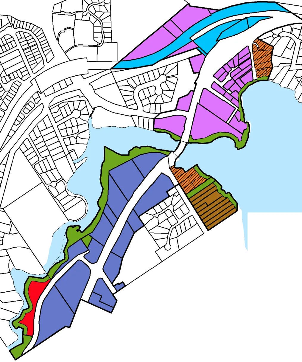
Land use transitions shown:
- MR to NV
- NMU to NV
- SSMUH & CF to NV
- SSMUH to IMU
- NMU to C
- C to WGEDC
- SSMUH & R to MR
- New Park designations at multiple waterfront and corridor locations
Proposed First Draft OCP Land Uses
| Land Use Designations | Existing WGC 2011 OCP Land Use Designations | Proposed WGC Land Use Designations |
|---|---|---|
| Small-Scale, Multi-Unit Housing | Detached and Attached Dwellings, including Duplex, Secondary Suite, Garden Suite, Rowhouse, Townhouse, Houseplex, and Apartments. • Up to 3 storeys • Up to 3 or 4 units, or up to 6 units if within 400 m of a prescribed transit stop |
No change. |
| Residential | Detached Houses and Townhouses • Up to 2.5 storeys • Max floor space ratio .6 permitted for appropriate infill |
No Change. |
| Mixed Residential | Small lot Detached Houses, Townhouses and Low-rise Apartments • Up to 3 storeys and 1.25:1 floor space ratio • Up to 4 storeys and 1.6:1 floor space ratio for apartments |
No change. |
| Neighbourhood Mixed Use | Commercial with Townhouses and Low-rise apartments. • Up to 3 storeys • 1.5:1 floor space ratio |
No change. |
| Intensive Mixed Use | Commercial with Townhouses and Low-rise apartments. • Up to 3 Storeys and 1.25 floor space ratio • Up to 4 storeys and 1.6 floor space ratio for Apartments |
No change. |
| Commercial | Retail, Office, Technology and Services. • Up to 4 Storeys • 2.5:1 floor space ratio |
No change. |
| Western Gateway Employment District Corridor | N/A | Commercial, arts and cultural uses, tourist accommodations, including light industrial uses (such as manufacturing, processing, warehousing, and technology). • Up to 6 storeys • 2.5:1 floor space ratio |
| Neighbourhood Village | N/A | Small-scale, mixed use developments that support multi-unit housing, commercial, and civic uses. • Up to 6 storeys • 2.5:1 floor space ratio |
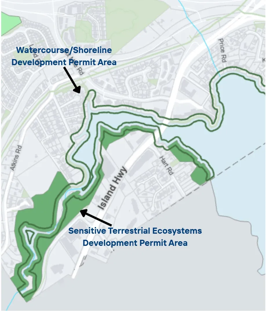
Existing Environmental Protections: Development Permit Areas
Two existing Development Permit Areas that protect natural areas, within the 2011 OCP:
- Natural Watercourse and Shoreline Area, applies 15 m up shore from ocean.
- Sensitive Terrestrial Ecosystems Area, applies 30 m from bank of stream/river.
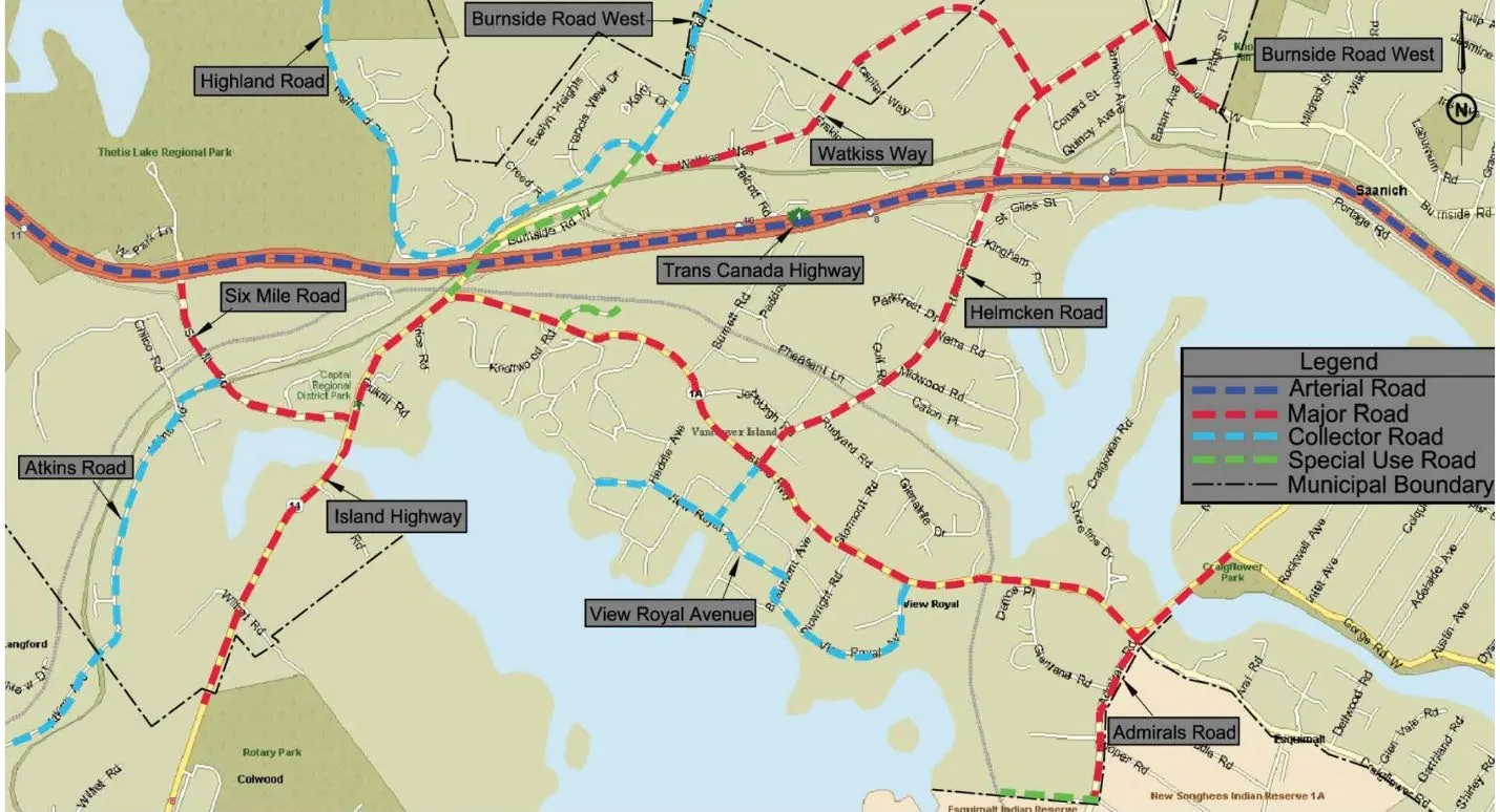
Road Network Map
Initial Reactions to Proposed Scenario
- What stands out to you most in the proposed Western Gateway scenario?
- What feels like the strongest or most compelling part of this approach?
- Is there anything in the scenario that surprised you or raises questions for you?
Focused Areas of Discussion
- Land-use and Density
- Transportation
- Environmental Protection
Focus Area – Land-use and Density
- What aspects of the scenario feel well-aligned with your vision for the corridor as a thriving employment hub?
- What parts of the proposed scenario create the uses [e.g. commercial, hotel, residential etc.] you want to see in the Western Gateway?
- Are there any refinements needed to strengthen the land-use or density within this scenario?
Focus Area – Transportation
- What aspects of the scenario feel well-aligned with your vision for transportation within the corridor?
- Are there any refinements needed to strengthen the scenario?
Focus Area – Environmental Protection
- How does the scenario support your environmental protection and climate objectives?
- Are there any refinements needed to strengthen the environmental protection and climate measures within the proposed scenario?
Council Discussion
- Overall, what elements of the Western Corridor scenario feel supportable to you?
- Where do you have concerns or unease?
- Are there any issues you feel require more analysis or consideration is needed?
Document Images
(1)