Attachment 3: FACILITATOR SUMMARY REPORT - Western Gateway Corridor Concept Review
Summary of a facilitated workshop held with Council on February 24, 2026, to discuss land use, density, and transportation in the Western Gateway Corridor.
Attachment 3

FACILITATOR SUMMARY REPORT
Official Community Plan Review and Update: Western Gateway Corridor Concept Review
Special Council Meeting - February 24, 2026
Submitted by: Katie Hamilton, Principal Tavola Strategy Group Ltd. tavolagroup.com | katie@tavolagroup.com
March 2026
TABLE OF CONTENTS
- OVERVIEW . . . . . . . . . . . . . . . . . . . . . . . . . . . . . . . . . . . . . . . . . . . . . . . . . . . . . . . . . 3
- Purpose . . . . . . . . . . . . . . . . . . . . . . . . . . . . . . . . . . . . . . . . . . . . . . . . . . . . . . . . 3
- Background . . . . . . . . . . . . . . . . . . . . . . . . . . . . . . . . . . . . . . . . . . . . . . . . . . . . . . 4
- Workshop Objectives . . . . . . . . . . . . . . . . . . . . . . . . . . . . . . . . . . . . . . . . . . . . . . 4
- Staff Presentation . . . . . . . . . . . . . . . . . . . . . . . . . . . . . . . . . . . . . . . . . . . . . . . . 5
- SUMMARY OF COUNCIL DISCUSSION . . . . . . . . . . . . . . . . . . . . . . . . . . . . . . . . . . . 6
- Overall reaction to proposed Western Gateway Corridor Concept . . . . . . . . . . 6
- Land-Use and Density . . . . . . . . . . . . . . . . . . . . . . . . . . . . . . . . . . . . . . . . . . . 10
- Transportation . . . . . . . . . . . . . . . . . . . . . . . . . . . . . . . . . . . . . . . . . . . . . . . . . . 12
- Environmental Protection . . . . . . . . . . . . . . . . . . . . . . . . . . . . . . . . . . . . . . . . 13
- PUBLIC QUESTION PERIOD . . . . . . . . . . . . . . . . . . . . . . . . . . . . . . . . . . . . . . . . . . 15
- COUNCIL MOTION . . . . . . . . . . . . . . . . . . . . . . . . . . . . . . . . . . . . . . . . . . . . . . . . . . 16
- NEXT STEPS . . . . . . . . . . . . . . . . . . . . . . . . . . . . . . . . . . . . . . . . . . . . . . . . . . . . . . . 17
- APPENDIX . . . . . . . . . . . . . . . . . . . . . . . . . . . . . . . . . . . . . . . . . . . . . . . . . . . . . . . XVIII
- Presentation Slides . . . . . . . . . . . . . . . . . . . . . . . . . . . . . . . . . . . . . . . . . . . . . xviii
OVERVIEW
Purpose
The purpose of this report is to summarize the facilitated workshop held with Council on February 24, 2026, which was convened as part of a Town of View Royal Special Council Meeting. The session was designed to provide Council with an opportunity to review and provide input on the proposed Western Gateway Corridor to inform preparation of the first draft of the Official Community Plan (OCP). The meeting was open to the public and members of the OCP Advisory Committee were invited to attend in-person or online.
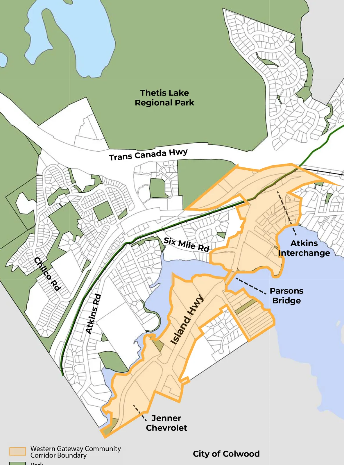
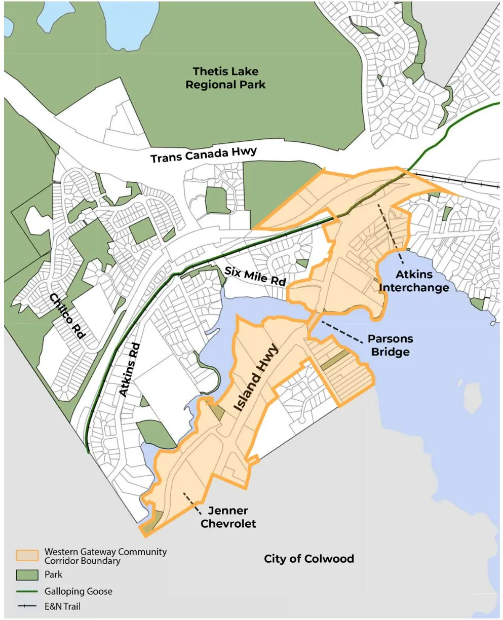
The Western Gateway corridor is located along Island Highway between the Colwood border and the Atkins Interchange in View Royal, British Columbia. It is an important connection between neighbourhoods, businesses, parks, and major transportation routes, including the Blink RapidBus line and the Galloping Goose Trail.
Background
At the February 17, 2026 Town of View Royal Council Meeting, Council ratified the following motion:
- THAT the Committee recommend to Council that a Special Council Meeting be held to gather Council’s input on the Western Gateway Corridor prior to the preparation of a draft OCP;
- AND THAT the OCP Advisory Committee be invited to attend the meeting;
- AND FURTHER THAT the meeting include a facilitated workshop at a cost not to exceed $5,000.
A workshop at the View Royal Town Hall was scheduled for Tuesday, February 24, 2026, in response to this direction and was structured to support a focused, solutions oriented review of the proposed Western Gateway Corridor land use concept.
Katie Hamilton from Tavola Strategy Group was retained to facilitate the session.
Workshop Objectives
The session was designed to support Council’s informed review of the proposal through the following objectives:
- Provide an overview of the 2011 OCP land use designation for the Western Gateway area.
- Present the proposed land use designations for the Western Gateway Corridor, including:
- land uses, building heights, densities and associated map changes
- Identify key differences between the 2011 OCP and the proposed land use concept.
- Provide additional technical detail, including:
- land use and density analysis
- transportation considerations
- environmental protection elements
To focus the discussion on areas requiring policy clarity, Council was advised at the outset of the meeting that the discussion was designed to garner Council’s feedback on the following:
- What elements of the proposal feel supportable?
- Where do you have concerns or hesitation?
- Are there any issues you feel require more analysis or consideration?
Council was reminded that facilitation would enable Councillors to seek clarity about the proposed Western Gateway Corridor concept through facilitated questions and comments, and any specific direction to staff would be invited by Mayor Tobias through a formal Council motion at the end of the meeting.
Staff Presentation
Leanne Taylor, Director of Development Services, and Stirling Scory, Senior Planner, delivered a comprehensive presentation to ground the workshop discussion in shared technical understanding of the proposed Western Gateway Corridor Concept. The overview presentation included a summary of the 2011 OCP land use designation for the Western Gateway area, the proposed land use designations, including intended uses, building heights, densities, and related map changes, and the key differences between the existing 2011 OCP and the proposed concept. Staff also provided additional technical detail related to land use and density considerations, transportation, and environmental protection.
The staff presentation is included in this report as an Appendix.
SUMMARY OF COUNCIL DISCUSSION
This summary is not intended to serve as the official minutes of the meeting. It reflects the facilitator’s notes and captures the key themes and discussion points shared by Council during the session. Formal minutes from the meeting are available at www.viewroyal.ca.
Overall reaction to proposed Western Gateway Corridor Concept
FACILITATOR posed the following questions to Council:
- What stands out to you most in the proposed Western Gateway scenario?
- What feels like the strongest or most compelling part of this approach?
- Is there anything in the scenario that surprised you or raises questions for you?
High-level themes that emerged:
- Several Councillors expressed overall support for the direction of the Western Gateway proposal
- Council sought clarity on a variety of topics:
- Height, massing, specific land uses [e.g. institutional, daycare, community facilities, transit-oriented areas, parks]
- Long term transportation implications [e.g. commercial vehicle access, interior roads]
- 1720 Wilfert Road, Atkins Interchange and land south of Parsons Bridge.
- Financial and servicing implications of different land uses, including the potential higher tax revenue of proposed light industrial uses and increased demand on municipal services.
- Staff clarified how different land use designations would guide residential, commercial, and mixed use development; how height would be determined through future development applications; and how provincial legislation may influence future density.
Detailed discussion:
COUNCILLOR BROWN – Liked the Mixed-Use Neighbourhood land use designation but was surprised to see no institutional uses or schools considered for the area.
COUNCILLOR LEMON – Agreed with Councillor Brown, the land use must include space for community facilities considered in public participation period [e.g. faith, civic, institutional, tourist accommodation].
Staff confirmed the land-uses would support the desired uses by the public and Council.
COUNCILLOR LEMON – Does not want a “canyon” that people drive through. There is concern that the buildings will be too tall and that the buildings will not be set back from the street far enough.
COUNCILLOR MATTSON – Likes the proposed land use and cited that the proposal clarifies and removes worry previously held for the area. Overall pleased with the proposal.
COUNCILLOR MATTSON – Could staff clarify if a hotel use is permitted?
Staff confirmed a hotel use could operate in both the Western Gateway Employment District Corridor and Neighourhood Village land use designations.
COUNCILLOR MATTSON – How did staff determine 6 storeys was preferred, instead of 4. What was staff’s rationale?
Staff clarified that it is up to 6 storeys, and that 6 storeys is not as of right approval. Staff, the applicant, and Council would work together to determine through development application process, via rezoning, if 6 storeys was suitable for the area. Council would have decision making authority over this. Council was reminded that development standards now require 6 storeys of wood frame construction to be economical viable, and anything smaller is not going to work. We will not see applications without variances. Staff also confirmed that where greater height is desired beyond 6 storeys, a minimum of 15 storeys is required for steel and construction to be viable. Staff clarified anything less would not be viable. Staff clarified that concerns with height, massing, building design, and site design are all addressed through the development permit process, via Form and Character Development Permit Area guidelines.
COUNCILLOR MATTSON – Noted concern that if say up to 6 storeys, we must do 6 storeys.
Staff clarified that up to six storeys does not mean that six storeys is required, it provides an option. Staff asked Council to recall the application process and reminded them that applications are reviewed by staff and Council and at that time are determined if 6 storeys is suitable for growth.
COUNCILLOR MATTSON – Asked if there was a possibility to split the amount of storeys between different uses with the possibility of having a 6-storey building split whereby, 4 storeys would be commercial, office, or industrial use, and 2 storeys would be residential. Possibility to do 4 commercial/office/industry plus residential.
Staff confirmed that residential uses are not considered in the Western Gateway Employment District Corridor south of Parsons Bridge, it is strictly for commercial and light industrial uses. Approximately 95% of the Town is residential, Council should consider the preservation of these lands for commercial and light industrial uses and preserve their development potential. The Neighbourhood Village land use designation would consider a mix of commercial and residential uses.
COUNCILLOR MATTSON – Asked if there are opportunities for residential in the Western Gateway Employment District Corridor. Is there any possibility?
Staff cited the challenges in doing so, but that there may be a small chance of having housing provided through an agency or provider, such as a housing provider, but cited challenges administratively in doing this. Staff reiterated the challenge of doing 6-storey wood frame development and clarified that splitting a development into 2 storeys each of commercial, light industrial, and residential use would not be viable for developers, and that staff are not aware of any local examples of such a development existing.
MAYOR TOBIAS – Expressed support for the overall Western Gateway concept but wanted to know if the proposed land uses would permit defense software/manufacturing as a possible business use.
Staff clarified that the Official Community Plan does not get into that level of detail but could be further refined in the Zoning Bylaw.
MAYOR TOBIAS – The Mayor wanted clarification of whether a performing arts centre (community centre) could be added to a building, specifically, if an interested party wanted to build a performing arts centre and then place a hotel on top and it was 15 storeys, would this be allowed?
Staff confirmed that this height would trigger an OCP amendment (subject to Council’s review), but that an interested applicant could apply.
MAYOR TOBIAS – Asked if staff could confirm whether or not the area next to the Atkins Interchange (being the area of land next to Island Highway between Atkins Road and the Trans Canada Highway) is currently a Transit-Oriented Area [TOA] (designated by the Province through Bill 47).
Staff confirmed that the area is not currently designated as a Transit-Oriented Area (TOA).
MAYOR TOBIAS – asked how much flexibility the Town will have in planning this area before the Province dictates how the lands will be developed (through legislation).
Staff confirmed that the lands would be regulated by Bill 47 and provincial legislation would specify height and density, but that the use would remain flexible.
MAYOR TOBIAS – Noted that development of the area would place greater demand on service needs. He noted more people will move from outside the community, and that the likelihood of local residents is likely low.
MAYOR TOBIAS – Asked staff to confirm what the tax implications are between industrial and commercial and residential uses and what this means for this area if designated for commercial versus light industrial use.
Staff noted that the light industrial tax rate is approximately four times greater than residential tax rate values.
COUNCILLOR ROGERS – Questioned why the height was 6 storeys across the entire area and noted that revisions and tweaking to the height would need to be made to have more height.
COUNCILLOR ROGERS – Asked staff to confirm what the current density is for the Western Gateway.
Staff confirmed that the existing density is 2.5:1 and the height is 4 storeys for the Commercial land use designation in the Western Gateway Corridor, under the 2011 OCP.
COUNCILLOR ROGERS – Provided feedback on the Atkins Interchange and potential for a Transit Oriented Area designation and felt that the area should be designated.
COUNCILLOR ROGERS – Requested that staff provide clarity on where walkable, shopping areas are in the Western Gateway Corridor.
Staff clarified that the Neighbourhood Village land use designation would be ideal to support shopping and walkability. Staff also noted that the Atkins Interchange is not a glorified park and ride, the OCP will provide land use capable of supporting broad range of uses. Staff noted that Council has provided conflicting feedback on the desired height and density for the area.
COUNCILLOR ROGERS – Expressed interest in a Provincial lobby to get a Bill 47 Transit-Oriented Area in the Atkins Interchange.
COUNCILLOR ROGERS – Requested that staff provide clarity on how the Western Gateway Corridor, particularly the area south of Parson’s Bridge, facilitates the movement of goods and services, and access to these sites.
Staff clarified for Council that Councillor Rogers was likely referring to the proposed interior road connection identified in the 2008 Transportation Master Plan. Staff noted that such a connection would severely impact the developability of the lands. The connection is not considered in the OCP update.
COUNCILLOR ROGERS – Requested that further details on the movement of goods and services, and site access be provided. The Councillor expressed concern over the access of commercial vehicles particularly and site design.
COUNCILLOR ROGERS – Liked the innovative approach, and likes the mix of land uses, but would have liked to have light industrial concepts from Victoria and the lower mainland area to help visualize what these areas could look like for Council.
COUNCILLOR LEMON – Would like a different colour option used for 1720 Wilfert Road. Asked staff to clarify why this property was commercial [noted in red].
COUNCILLOR MATTSON – Requested clarity on whether the Wilfert Road site (1720 Wilfert) would permit daycare and asked if daycare is a commercial use.
COUNCILLOR MATTSON – Asked how the 30-metre buffer is determined.
Staff explained that the 30-metre buffer is calculated by survey and is taken by bird’s eye view.
COUNCILLOR ROGERS – Noted that slope failure for the Millstream area is likely, and that the area is very sensitive. The Councillor also stated that geotechnical assessments are important for the area.
COUNCILLOR ROGERS – Asked staff how many employees would the scenarios generate for these areas.
Staff noted they have not conducted an analysis to determine this number.
COUNCILLOR ROGERS – Suggested that staff work with Prospera Group to provide this information.
MAYOR TOBIAS – Asked why park land was missing in Scenario 3, from the presentation and agenda package.
Staff clarified that the park land was not part of the 2011 land use designation, and that it was only added in Scenarios 1 and 2 for consideration as a future land use.
MAYOR TOBIAS – Asked staff to clarify if the Park land use designations would permit trails.
Staff clarified that this land use does not mean trails necessarily, as it depends on the site, and will ultimately be determined through the Parks and Trails Master Plan.
COUNCILLOR BROWN – Asked if staff had considered the road extension from the City of Colwood to the Town of View Royal, via the Wilfert Road extension.
COUNCILLOR MATTSON – Stated that it is really important to tell public we are not taking their property and turning it into park.
Staff clarified that the intent of the land use designations is not to overregulate, and that the Park land use designations follow the Environmental Development Permit Area. Staff also clarified that the land use designations are not intended to expropriate lands, and that park land would not be formerly established until the time of an application.
COUNCILLOR ROGERS – Noted that a developer had come to Council a year ago about to discuss the development potential of Hart Road.
COUNCILLOR ROGERS – Asked staff to provide an explanation for how the parking requirements for the Western Gateway Corridor (via the Land Analysis shared in the agenda and Council package) were calculated. How did staff determine 16,000 spaces are required?
Staff clarified that the land analysis referenced is a high-level analysis completed to provide information for discussion purposes, and that the calculations were based on current parking requirements in the Zoning Bylaw. The current parking requirements were calculated roughly by the gross floor area but is not indicative of what may be needed or wanted in the future, and it does not consider site context, constraints, permit requirements, or variances. This only represents a highest density scenario.
COUNCILLOR MATTSON – Stated if Council were to receive a 15-storey proposal, and Council really liked it, Council would not turn it down.
COUNCILLOR ROGERS – Disagreed with this statement, stating that not every Council would allow this, and that staff may not allow this. The Councillor expressed concerns with access.
FACILITATOR - Asked Council whether there was any additional clarity needed before moving to specific topics of land-use, transportation and environmental protection, as it relates to the Western Corridor Gateway concept. Council was comfortable moving forward with discussion by topic.
Land-Use and Density
FACILITATOR posed the following questions to Council:
- What aspects of the scenario feel well aligned with your vision for the corridor as a thriving employment hub?
- What parts of the proposed scenario create the uses [e.g. commercial, hotel, residential etc.] you want to see in the Western Gateway?
- Are there any refinements needed to strengthen the land-use or density within this scenario?
High-level themes that emerged:
- Councillors discussed future land use and density in the Western Gateway Corridor, focusing on how proposed designations can support a mix of homes, jobs, services, and potential future rail opportunities.
- The importance of land uses that complement nearby neighbourhoods and create attractive public spaces was emphasized.
- The suitability of specific sites, particularly 1720 Wilfert Road, given environmental sensitivities, slope conditions, and existing zoning was raised.
- Staff confirmed that the draft land use designations aim to balance mixed use development with environmental protection, protect potential rail opportunities, and support the area evolving into a vibrant, accessible district over time.
Detailed discussion:
MAYOR TOBIAS – Expressed concern with two areas. First, the Transit Area. The Mayor requested that staff clarify if an applicant would need industrial zoning for the rail tracks. Second, would the OCP land use designation impact the rail corridor/ What about all the owners?
Staff confirmed there are multiple owners, and that the blue land use shows the CRD Galloping Goose Trail. The OCP will have policies that support rail corridor development.
MAYOR TOBIAS – Expressed concern over the challenges and considerations for next door neighbours, and that the uses here should complement neighbourhood.
MAYOR TOBIAS - Asked if there could be a potential rail stop in the Neighbourhood Village land use designation that would support restaurants and shopping in View Royal?
Staff confirmed that yes, this would be possible, and that the Neighbourhood Village land use designation would facilitate opportunities for people to live and work, and could also be a destination. The Neighbourhood Village land use would facilitate these uses.
COUNCILLOR MATTSON – Is really pleased with what he sees. Lot of issues that we have heard will be addressed. Only potential issue is the bottom half of commercial. Would like to see Wilfert parcel changed that could be something that permits residential.
COUNCILLOR BROWN – Likes the idea of linear parks. Especially those along water. Building corridor up, regardless of what is there would like to see rooftop amenities (gardens, playing areas, soccer). Would like to see lots of trees.
COUNCILLOR LEMON – Likes the proposed draft land use designations. Feels comfortable. Loves the possibility of entertainment and dining around the train stop in the future. Felt that the “red blob” (1720 Wilfert Road) seems random. Make it mixed residential. Consider impacts as well (to the environment).
MAYOR TOBIAS – Asked staff to clarify what Council would have to do to change the proposed land use designation for the Wilfert Road parcel (1720 Wilfert Road).
Staff clarified that the current land use designation (in the 2011 OCP) for 1720 Wilfert Road is Neighbourhood Mixed Use. This site has limitations for development, including a Sensitive Environmental Development Permit Area., and that on-site considerations would need to be factored in, including parking requirements, retaining walls, etc. Staff suggested that the existing land use designation be retained, or that if there was a desire for residential Intensive Mixed Use land use designation could be considered. Council was reminded that their focus should not be on a single parcel, rather the compatibility of uses and vision for the area as a whole. Considerations for a site design is not solely up for staff and is reviewed at Development Permit stage. Staff asked Council to think about whether Council wanted to permit residential use on the site (1720 Wilfert Road), or if their preference was to focus on commercial use only.
MAYOR TOBIAS – Requested clarification from staff and asked if the property was designated Neighbourhood Mixed Use (current 2011 OCP land use designation), would this permit daycare and residential use?
Staff confirmed that the Neighbourhood Mixed Use would allow both daycare and residential uses and further clarified that the site must be mixed-use (commercial and residential). Staff asked Council to consider whether more commercial density was desired for the area. If so, staff suggestion to Council was to consider designating the subject property (1720 Wilfert Road) the new Western Gateway Employment District Corridor land use designation. In doing so, residential use would not be permitted.
COUNCILLOR ROGERS – Stated that the site (1720 Wilfert Road) is an environmentally sensitive area with known slope issues.
COUNCILLOR ROGERS – Suggested that the property (1720 Wilfert Road) be split designated, where the southern portion of the property be designated Park and green space. The Councillor expressed concern over the use of the site, saying the Town has been sued in the past over similar issues. Expressed concern over build out and use and noted the parcel should be a park.
COUNCILLOR MATTSON – Requested staff clarify what the current zoning of the parcel (1720 Wilfert Road) is.
Staff confirmed that the current Zoning for the site (1720 Wilfert Road) is C7 – Business Park Commercial.
COUNCILLOR ROGERS – Asked staff if they could explain why there are properties designated Intensive Mixed Use along Price Road, next to residential properties.
Staff clarified that the intent would be that persons living here could make use of multi-modal forms of transportation, the details of which would be covered in a future Transportation Master Plan. Staff also explained that the Intensive Mixed Use land use designation is a lower density than the proposed Neighbourhood Village Designation, and would provide a buffer, while still providing density and mixed-use development in this identified growth area. Staff went on to say that the area is a known challenge area, containing bedrock, which may make development challenging.
COUNCILLOR ROGERS – Critiqued staff’s land use analysis and asked if 2.3 people per unit was too high, particularly for small studio and one-bedroom units.
COUNCILLOR BROWN – Asked whether zoning be permitted for dog parks.
Staff confirmed that these site-specific uses will be addressed via a zoning application, and that the OCP is a high-level document. The OCP should not be overly prescriptive, otherwise the Town would not receive unique applications.
FACILITATOR - Asked Council whether there was any additional information or refinements needed to strengthen the land-use or density within this scenario. None were noted.
Transportation
FACILITATOR posed the following questions to Council:
- What aspects of the scenario feel well aligned with your vision for transportation within the corridor?
- Are there any refinements needed to strengthen the scenario?
High-level themes that emerged:
- The importance of infrastructure and stakeholder coordination as the area grows were noted.
- Some concerns about long-term traffic capacity, access points, and regional constraints such as the 6 Mile bridge were raised, noting that new development may increase demand on local streets.
Detailed Discussion:
MAYOR TOBIAS – Noted the important convergence of trail/Atkins/Trans-Canada Highway and potential for light rail. Commented that the Atkins area will become increasingly important as legislation is developed, and that because of this the infrastructure required needs to be in place and the stakeholders involved need to be invited. To make this area successful, the Town needs to have the appropriate infrastructure.
MAYOR TOBIAS – Commented that the Town has relied on Casino revenue in the past, and that moving forward, the Town may need to shift its reliance, there may come a day where maybe the casino is not there in the future. Noted the contributions the Casino has provided over the years and its help, but that the Town should prepare that something might change.
COUNCILLOR ROGERS – Commented that people are not going to get out of cars and that this area is not an area only serviced by bus transportation. Hopefully this area is reducing the minutes for people to get to services. Dubious that art centre is viable. The 6-mile bridge is a constraint. Questioned how we as a region are going to address this. Buses need to time service. All that commercial development is going to have to come out of two lights. We need a major street configuration to permit traffic. If we have density, need to permit access. Noted concern with Price Road and Western Gateway Corridor Plan.
FACILITATOR asked Council whether there were any refinements needed at this time to strengthen transportation within the scenario presented. None were noted.
Environmental Protection
FACILITATOR posed the following questions to Council:
- How does the scenario support your environmental protection and climate objectives?
- Are there any refinements needed to strengthen the environmental protection and climate measures within the proposed scenario?
High-level themes that emerged:
- Council discussed opportunities to protect the environment in the Western Gateway Corridor, including stormwater management, ensuring slope stability, expanding green space, and safeguarding sensitive areas such as Millstream Creek.
- Staff noted that existing development permit guidelines and provincial regulations provide environmental protections and that future updates to the Official Community Plan and development guidelines will strengthen these requirements as the area redevelops.
Detailed Discussion:
MAYOR TOBIAS – Asked staff to clarify how stormwater runoff is managed and observed that the area has steep elevations and observed further that Langford is seeing foam in their water. Expressed concern for the area, and industrial uses, and wants the Town to consider stormwater management in the area.
Staff confirmed that the Town has development permit guidelines that address sediment erosion and runoff, and further regulations are provided in the Subdivision and Development Bylaw. Staff clarified that applications are submitted to the Province for review and compliance with regulations and Acts.
COUNCILLOR BROWN – Expressed interest in seeing more green space on site. Green space on top of buildings. Considering natural asset inventory for budget, need to think about green space in designing these areas.
COUNCILLOR ROGERS – Expressed concern with slope stability and requested that staff provide slope stability information, contours, and soil make ups. Asked staff if the Town would be including information on past failures?
Staff clarified that applicants are required to provide information to satisfy geotechnical requirements and reminded Council that once this phase of the Official Community Plan review and update concludes, staff will begin undertaking a review of the development permit area guidelines.
COUNCILLOR ROGERS – Asked staff to clarify how a landscaped area is allowed to be altered.
Staff confirmed that alteration of a landscaped area is subject to Development Permit Area permit requirements. Staff look at each parcel on a case-by-case basis and sometimes will ask that applicants provide supporting documentation and reports prepared by geotechnical engineers at the development permit or building permit stage. The tool that Council desires is the development permit area designation and legislation.
COUNCILLOR MATTSON – Noted that the Western Gateway Corridor is currently a sea of cement, and asked staff how we would go about making this area greener.
Staff stated that the area would become increasingly more green as the land redevelops.
COUNCILLOR BROWN – Commented that Saint John’s Newfoundland has very aesthetically pleasing buildings and would like to see the use of colours and hardy plank building styles, and the staggering of buildings.
COUNCILLOR ROGERS – Stated that the Millstream Creek area is an estuary.
Staff confirmed that the Millstream Creek area is captured under the streamside protection areas via the province, and that a 30-metre protection area applies.
FACILITATOR asked Council whether there were any refinements needed to the environmental protection measures within the concept. None were noted.
Council indicated there was no further information required and was comfortable moving to Public Question Period.
PUBLIC QUESTION PERIOD
Prior to Council considering any motions related to the Western Gateway Corridor Concept, members of the public online and present in Council Chambers were invited by the Mayor to ask questions and share their thoughts on the Western Gateway Corridor Concept.
High-level themes that emerged:
- Residents shared a range of views on the proposed land uses, including concerns about building height, need for more green space in this Corridor, and interest in both better understanding and expanding the Neighbourhood Village concept.
- Comments noted the need for light industrial uses to not impact nearby streams, and the need for transportation and infrastructure to keep pace with growth.
- The opportunity for new amenities and destinations was noted [e.g. hotel, parks and greenspace, transportation].
Detailed Discussion
RESIDENT – Prefers the medium growth option, including the variety it offers. Emphasized need for a broad urban planning approach, e.g. Dockside Green in Victoria. Likes the idea of rapid transit and rail. Expressed concern with having 6-storey building within the Neighbourhood Village land use designation concept.
RESIDENT – Stated support for the proposed land uses north of Parsons Bridge, and that the area south of the bridge appears to stay the same. They would like to see the Neighbourhood Village along this area as well (south of Parsons Bridge). They expressed concern over the proposed industrial uses and environmental impacts. They noted there is no proposed green space around the Neighbourhood Village area. They like the idea of this area being a transit corridor and community use.
MAYOR TOBIAS – Asked staff to clarify what is considered to be light manufacturing. The Town won’t see car manufacturing?
Staff indicated this is a possibility but not likely given the size. More likely to see food production products [e.g. jam or hummus] or high tech. Another possibility is warehousing to store products or processing microchips. All of these uses would need to be enclosed, without any outside storage. Fumes and noises are not going to impact surrounding neighbourhood.
MAYOR TOBIAS – Asked staff to confirm that residential uses are not permitted in the proposed Western Gateway Employment District Corridor.
Staff confirmed that the Mayor was correct, and said that the development of the Corridor also considers the potential for growth in the neighbouring City of Colwood growth area (Triangle Lands) along Island Highway and Goldstream.
RESIDENT – Expressed their interest in the second “medium growth” option. Overall, they like the concept of the Neighbourhood Village. Green spaces and spaces for people need to be provided. They hope that transportation and infrastructure can keep pace with growth. Stated that the Town has a lot of seniors and young families in this community and everyone cannot take transit. The Town needs to be mindful of the varying transportation needs of the community.
RESIDENT – Expressed their support for the proposed Western Gateway Corridor land use map and added that the Town needs a hotel in the area.
COUNCIL MOTION
Following Public Question Period, Mayor Tobias invited Council motions related to the Western Corridor Gateway concept to inform preparation of the draft Official Community Plan.
Council Discussion:
MAYOR TOBIAS – Asked staff to clarify that the proposed Western Gateway Corridor land use designations (Western Gateway Employment District Corridor and Neighbourhood Village) permit a hotel anywhere.
Staff confirmed that the proposed land use designations would support a hotel use, and the existing zones would permit this (no rezoning is required).
MAYOR TOBIAS – Asked if staff would like to have a motion.
Staff clarified that a motion is only needed if a specific change was requested. Staff stated that staff have heard that extending the Western Gateway Employment District Corridor land use to the Wilfert Road site (1720 Wilfert Road) is desired. Do not need to have specific motion.
COUNCILLOR MATTSON – We want to have split between residential and commercial use on site (1720 Wilfert Road).
Staff clarified for Council that the current zoning does not permit residential use, but that the land use designation does.
COUNCILLOR MATTSON – Stated that he would like to see the second bump as residential.
Staff requested that Council provide a motion for the land use change for the Wilfert Road property.
COUNCILLOR ROGERS – Noted confusion about the possibility of commercial use in the Intensive Mixed Use land use designation. He requested that staff bring back information for Council, and that this be written information to consider implications for the different designations of this site.
MAYOR TOBIAS – Reminded Council they do not have time to do this and that they are on a tight timeline.
Staff suggested that the motion be to retain the existing 2011 OCP land use designation, being the Neighbourhood Mixed Use, and not change the land use to commercial, as shown in the proposed land use map presented to Council this evening.
Council passed the following motion:
Moved By: Councillor Lemon Seconded By: Councillor Mattson
C-27-26 THAT the proposed Commercial land use designation for the parcel on Wilfert Road be changed to Neighbourhood Mixed-Use, consistent with the existing 2011 Official Community Plan land use designation.
NEXT STEPS
Tavola Strategy Group committed to producing a Facilitator Summary Report and staff would prepare the first draft of the Official Community Plan for public consultation, including the Council direction from the February 24th workshop.
APPENDIX
Presentation Slides
Western Gateway Corridor Official Community Plan Update Review of Draft Western Gateway Corridor Scenario Special Council Meeting – February 24, 2026
Western Gateway Corridor Council Motion At the February 17, 2026, Council Meeting, Council ratified the following motion: THAT the Committee recommend to Council that a Special Council meeting be held to gather Council’s input on the Western Gateway Corridor prior to the preparation of a draft Official Community Plan (OCP); AND THAT the OCP Advisory Committee be invited to attend the meeting; AND FURTHER THAT the meeting include a facilitated workshop at a cost not to exceed $5,000. Special Council Meeting – February 24, 2026
Western Gateway Corridor Purpose of Discussion Provide Council with an opportunity to review and provide input on the proposed Western Gateway Corridor to inform the first draft of the Official Community Plan. Special Council Meeting – February 24, 2026
Western Gateway Corridor Objectives of Technical Presentation
- Provide an overview of the 2011 OCP land use designation.
- Present the proposed land use designations for the Western Gateway Corridor, including uses, heights and densities, and associated map changes.
- Identify key differences between the 2011 OCP and the proposed plan.
- Provide additional technical detail on land use and density, transportation and environmental protection. Special Council Meeting – February 24, 2026
Western Gateway Corridor What we are looking for from Council tonight
- What elements of the proposal feel supportable?
- Where do you have concerns or hesitation?
- Are there any issues you feel require more analysis or consideration?
Specific direction on Western Gateway Corridor scenario must be brought forward as a Council motion, following discussion. Special Council Meeting – February 24, 2026
Western Gateway Corridor Outcomes from Tonight's Discussion
- Facilitator summary report
- Revised Western Gateway Corridor scenario as per Council’s motion Special Council Meeting – February 24, 2026
Western Gateway Corridor Spirit of Engagement
- Welcome a diversity of perspective
- Stay curious, not judgmental
- Honour our time together
- Build upon each other's ideas
- Aim for direction, not perfection Special Council Meeting – February 24, 2026
Western Gateway Corridor OCP Background and Context
- An Official Community Plan (OCP) is a bylaw that is a reflection of community values and guides decisions on land use, housing, transportation, parks, environmental stewardship, economic development, etc.
- An OCP must contain statements and map designations to meet 20-year housing needs, along with an outline of present and proposed land uses, greenhouse gas targets, and more. Special Council Meeting – February 24, 2026
Western Gateway Corridor OCP Western Gateway Corridor Council expressed an interest in exploring the Western Gateway further as part of the OCP review and update, during the June 10, 2025, Council meeting.
Desired outcomes:
- Explore the potential for this area to become an employment hub.
- Consider a mix of commercial, tourist accommodation, some light industrial, and residential uses. Special Council Meeting – February 24, 2026
Western Gateway Corridor Engagement on Western Gateway Corridor Vision and Guiding Principles Survey: January 24 – February 18, 2025
- Completion of broad value and vision questions, plus a mapping exercise.
Business Mixer Workshop: March 6, 2025
- Explore the opportunities and challenges for business growth in View Royal.
Community Growth Survey: March 7 – April 4, 2025
- Explore interest and supportability of density and growth in existing corridors and neighbourhood centres, as well as land use (commercial and industrial vs residential) interest in the Western Gateway.
Western Gateway Corridor Engagement: October 7 – November 21, 2025
- Explored broad visioning questions and priority improvement areas, along with three land use scenarios.
- Western Gateway Corridor Survey - October 7 – November 21, 2025
- Community Workshop - October 18, 2025
- Open Houses - October 18 and 22, 2025
- Focus Group: Business & Landowner Workshop – October 21, 2025 Special Council Meeting – February 24, 2026
Western Gateway Corridor Western Gateway Scenarios Review (October 7 – November 21 Engagement)
Scenario 1: High Growth
Potential Growth and Development*:
- Residential Units: 2,200 [up to 5,375]
- Population: 5,100 [up to 12,300]
- Commercial Floor Area: 238,500 m2
- Light Industrial Floor Area: 160,400 m2
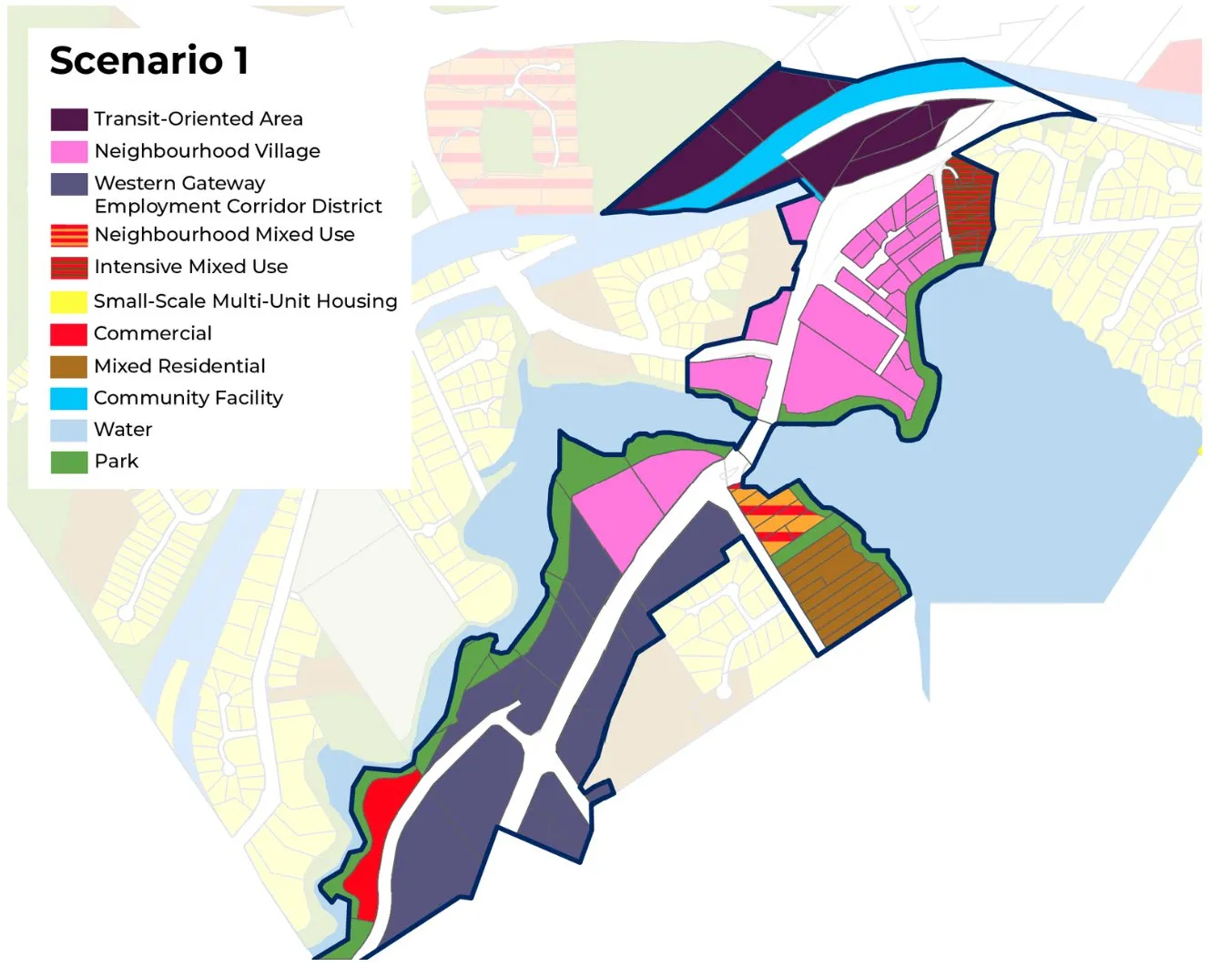
Analysis Assumptions* The potential growth scenario assumes that each parcel will be redeveloped and will be built to the maximum potential density. In addition, the scenarios do not consider on-site constraints, such as site and soil conditions, environmental setbacks, or permit requirements. Special Council Meeting – February 24, 2026
Western Gateway Corridor Western Gateway Scenarios Review (October 7 – November 21 Engagement)
Scenario 2: Medium Growth
Potential Growth and Development*:
- Residential Units: 1,700 [up to 3,800]
- Population: 3,900 [up to 8,700]
- Commercial Floor Area: 204,000 m2
- Light Industrial Floor Area: 155,000 m2
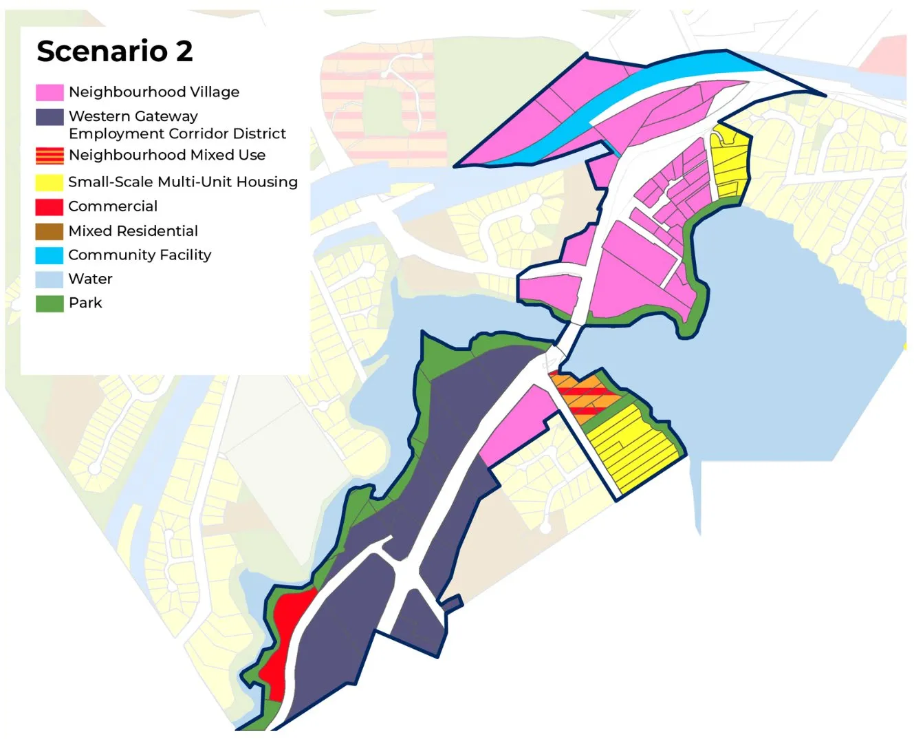
Analysis Assumptions* The potential growth scenario assumes that each parcel will be redeveloped and will be built to the maximum potential density. In addition, the scenarios do not consider on-site constraints, such as site and soil conditions, environmental setbacks, or permit requirements. Special Council Meeting – February 24, 2026
Western Gateway Corridor Western Gateway Scenarios Review (October 7 – November 21 Engagement)
Scenario 3: Low Growth (Existing 2011 OCP)
Potential Growth and Development*:
- Residential Units: 1,400 [up to 2,200]
- Population: 3,300 [up to 5,075]
- Commercial Floor Area: 311,000 m2
- Light Industrial Floor Area: 0 m2
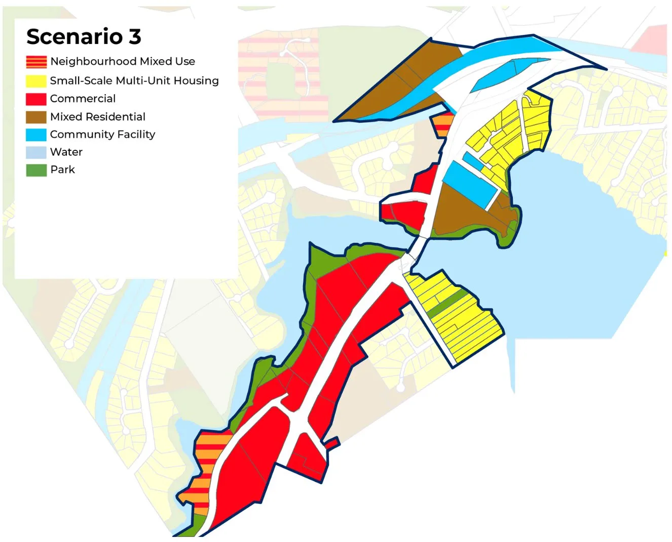
Analysis Assumptions* The potential growth scenario assumes that each parcel will be redeveloped and will be built to the maximum potential density. In addition, the scenarios do not consider on-site constraints, such as site and soil conditions, environmental setbacks, or permit requirements. Special Council Meeting – February 24, 2026
Western Gateway Corridor Preferred Scenario: Engagement Feedback
- 100 total responses were provided to indicate the preferred scenario.
- 39% of respondents preferred Scenario 2 (Medium Growth)
- 27% of respondents preferred Scenario 1 (High Growth)
- 17% of respondents preferred a hybrid of scenarios.
- 14% of respondents preferred Scenario 3 (Low Growth – 2011 OCP land uses) Special Council Meeting – February 24, 2026
Western Gateway Corridor 2011 OCP Land Use Map
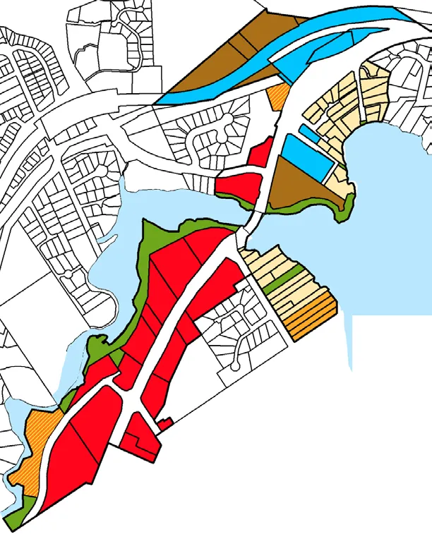
Potential Land Use Capacity*:
- Total Retail Area: 311,000 m2
- Total Industrial Area: 0 m2
- Total Residential Area: 132,000 m2
- Total Residential Units: 2,200
- Total Population: 5,075
Analysis Assumptions* The potential growth scenario assumes that each parcel will be redeveloped and will be built to the maximum potential density. In addition, the scenarios do not consider on-site constraints, such as site and soil conditions, environmental setbacks, or permit requirements. Special Council Meeting – February 24, 2026
Western Gateway Corridor Proposed Land Use Map
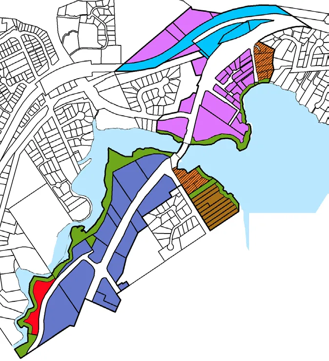
Potential Land Use Capacity*:
- Total Retail Area: 225,000 m2
- Total Industrial Area: 152,000 m2
- Total Residential Area: 259,000 m2
- Total Residential Units: 4,480
- Total Population: 10,310
Analysis Assumptions* The potential growth scenario assumes that each parcel will be redeveloped and will be built to the maximum potential density. In addition, the scenarios do not consider on-site constraints, such as site and soil conditions, environmental setbacks, or permit requirements. Special Council Meeting – February 24, 2026
Western Gateway Corridor Existing 2011 OCP Land Uses / Proposed First Draft OCP Land Uses

Special Council Meeting – February 24, 2026
Western Gateway Corridor
| Proposed First Draft OCP Land Uses | Existing WGC 2011 OCP Land Use Designations | Proposed WGC Land Use Designations |
|---|---|---|
| Small-Scale, Multi-Unit Housing | Detached and Attached Dwellings, including Duplex, Secondary Suite, Garden Suite, Rowhouse, Townhouse, Houseplex, and Apartments. • Up to 3 storeys • Up to 3 or 4 units, or up to 6 units if within 400 m of a prescribed transit stop |
No change. |
| Residential | Detached Houses and Townhouses • Up to 2.5 storeys • Max floor space ratio .6 permitted for appropriate infill |
No Change. |
| Mixed Residential | Small lot Detached Houses, Townhouses and Low-rise Apartments • Up to 3 storeys and 1.25:1 floor space ratio • Up to 4 storeys and 1.6:1 floor space ratio for apartments |
No change. |
| Neighbourhood Mixed Use | Commercial with Townhouses and Low-rise apartments. • Up to 3 storeys • 1.5:1 floor space ratio |
No change. |
| Intensive Mixed Use | Commercial with Townhouses and Low-rise apartments. • Up to 3 Storeys and 1.25 floor space ratio • Up to 4 storeys and 1.6 floor space ratio for Apartments |
No change. |
| Commercial | Retail, Office, Technology and Services. • Up to 4 Storeys • 2.5:1 floor space ratio |
No change. |
| Western Gateway Employment District Corridor | N/A | Commercial, arts and cultural uses, tourist accommodations, including light industrial uses (such as manufacturing, processing, warehousing, and technology). • Up to 6 storeys • 2.5:1 floor space ratio |
| Neighbourhood Village | N/A | Small-scale, mixed use developments that support multi-unit housing, commercial, and civic uses. • Up to 6 storeys • 2.5:1 floor space ratio |
Special Council Meeting – February 24, 2026
Western Gateway Corridor Existing Environmental Protections: Development Permit Areas
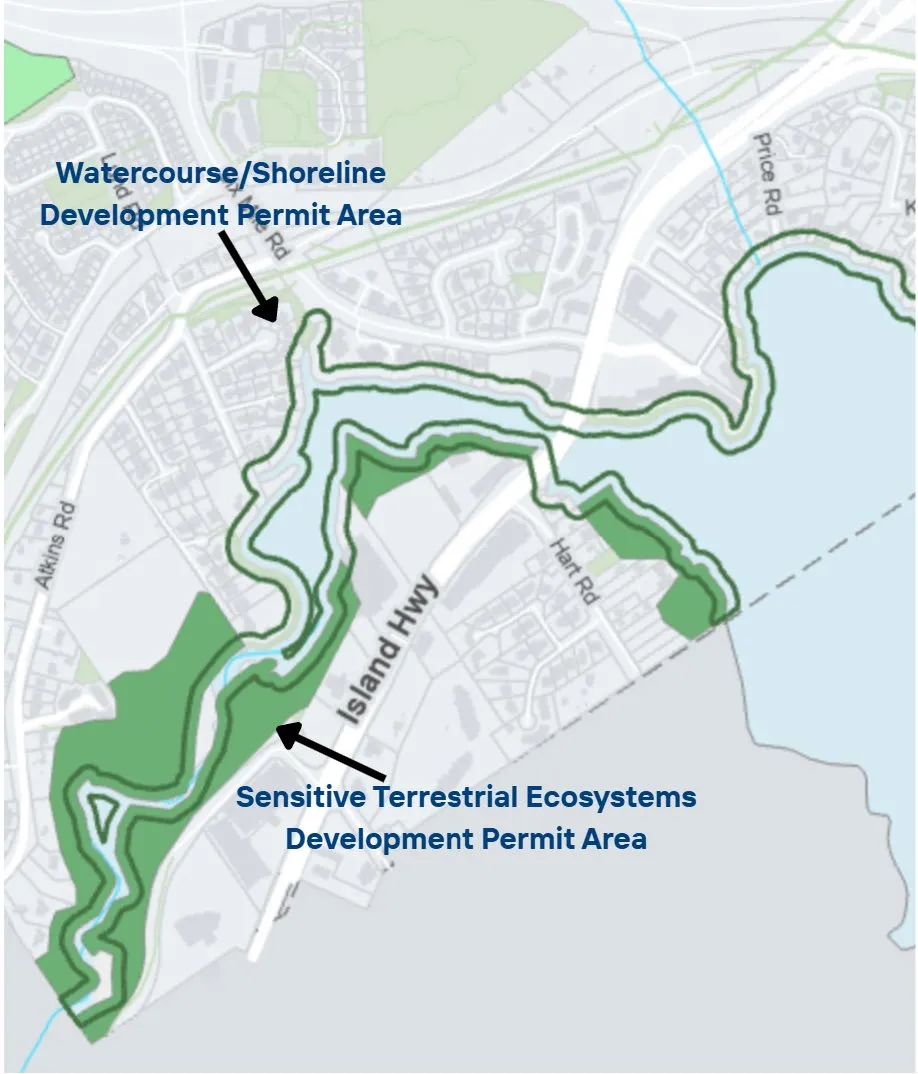
Two existing Development Permit Areas that protect natural areas, within the 2011 OCP:
- Natural Watercourse and Shoreline Area, applies 15 m shore from ocean.
- Sensitive Terrestrial Ecosystems Area, applies 30 m from bank of stream/river. Special Council Meeting – February 24, 2026
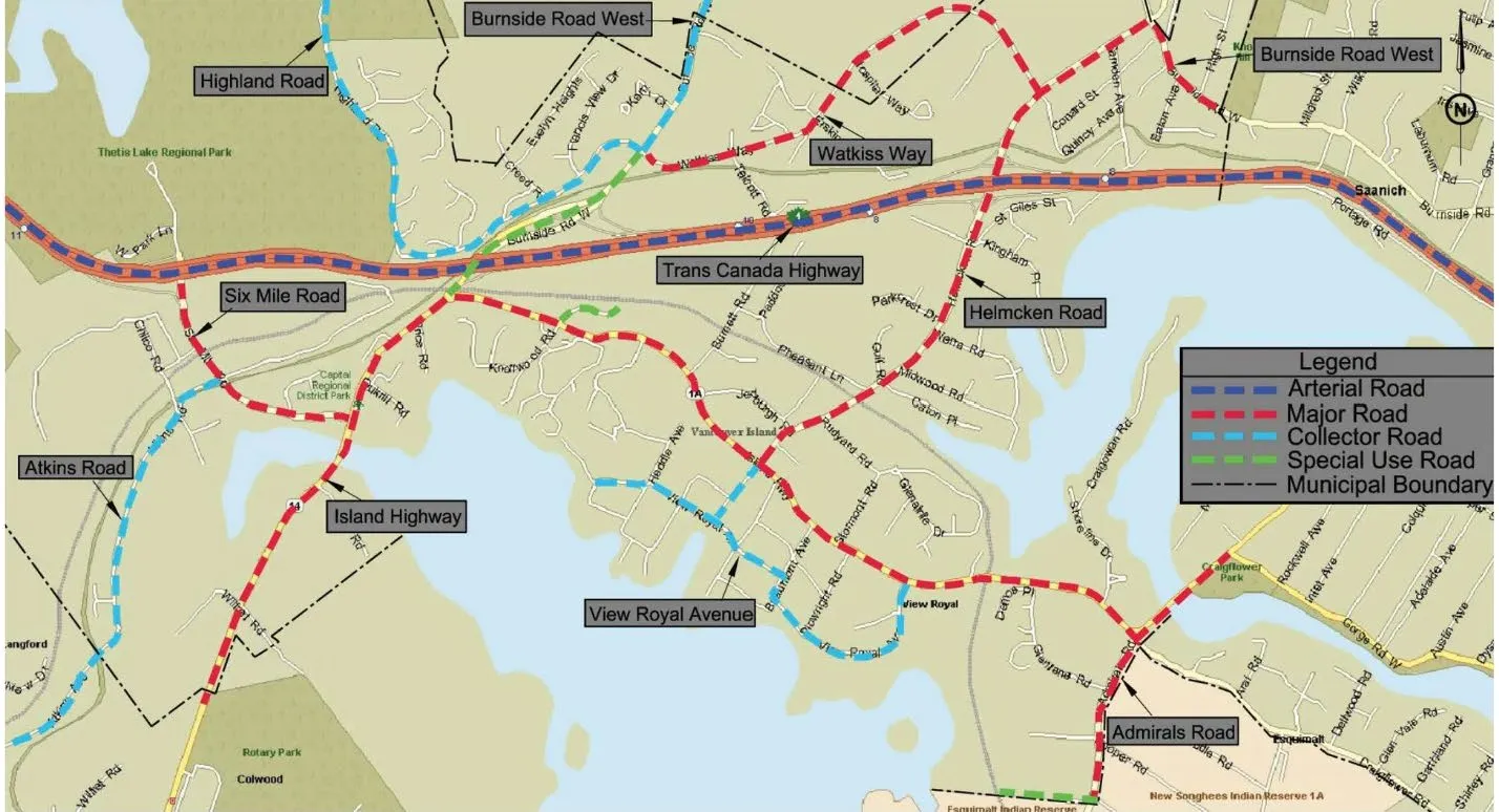
Western Gateway Corridor Road Network Map
Special Council Meeting – February 24, 2026
Western Gateway Corridor Initial Reactions to Proposed Scenario
- What stands out to you most in the proposed Western Gateway scenario?
- What feels like the strongest or most compelling part of this approach?
- Is there anything in the scenario that surprised you or raises questions for you? Special Council Meeting – February 24, 2026
Western Gateway Corridor Focused Areas of Discussion
- Land-use and Density
- Transportation
- Environmental Protection Special Council Meeting – February 24, 2026
Western Gateway Corridor Focus Area – Land-use and Density
- What aspects of the scenario feel well-aligned with your vision for the corridor as a thriving employment hub?
- What parts of the proposed scenario create the uses [e.g. commercial, hotel, residential etc.] you want to see in the Western Gateway?
- Are there any refinements needed to strengthen the land-use or density within this scenario? Special Council Meeting – February 24, 2026
Western Gateway Corridor Focus Area – Transportation
- What aspects of the scenario feel well-aligned with your vision for transportation within the corridor?
- Are there any refinements needed to strengthen the scenario? Special Council Meeting – February 24, 2026
Western Gateway Corridor Focus Area – Environmental Protection
- How does the scenario support your environmental protection and climate objectives?
- Are there any refinements needed to strengthen the environmental protection and climate measures within the proposed scenario? Special Council Meeting – February 24, 2026
Western Gateway Corridor Council Discussion
- Overall, what elements of the Western Corridor scenario feel supportable to you?
- Where do you have concerns or unease?
- Are there any issues you feel require more analysis or consideration is needed? Special Council Meeting – February 24, 2026
Document Images
(1)