Attachment 3: Meadowvale Drive Covenant Monitoring: Initial Inspection Report
A comprehensive monitoring report prepared by Halladay Environmental Consultants Ltd. documenting site conditions and breaches of the covenant areas.
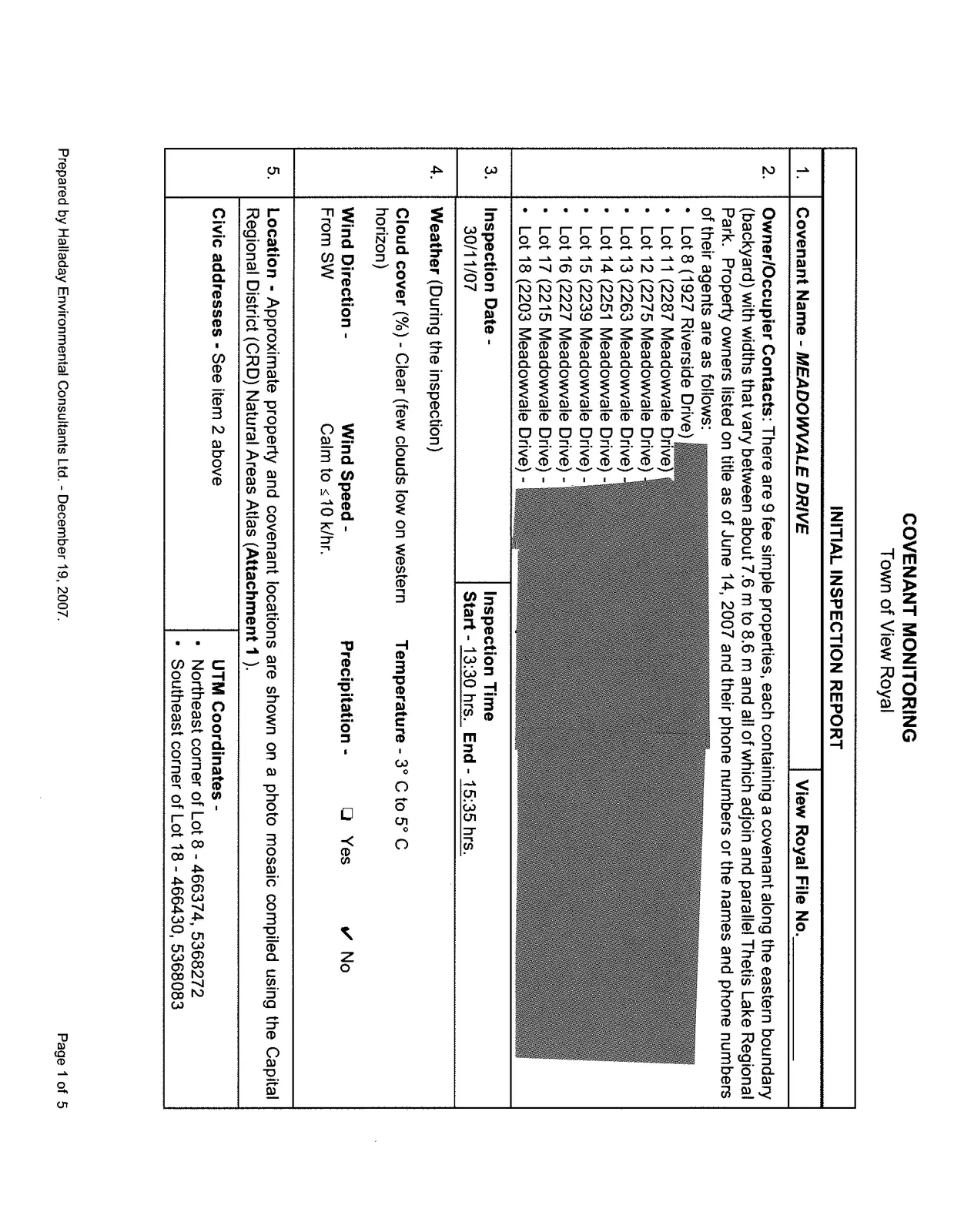
This report summarizes the initial covenant monitoring inspection for Meadowvale Drive in the Town of View Royal.
COVENANT MONITORING
Town of View Royal
INITIAL INSPECTION REPORT
| 1. | Covenant Name - MEADOWVALE DRIVE | View Royal File No. ________ |
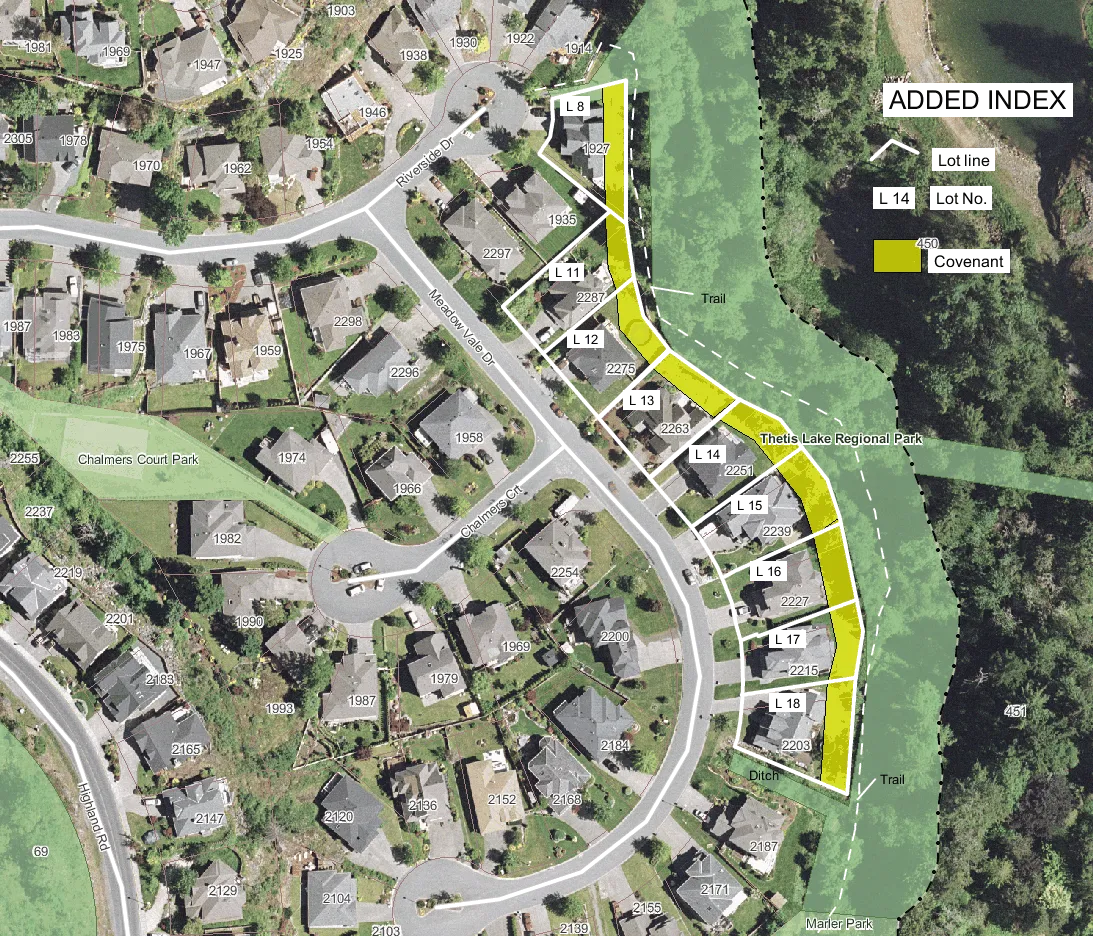
| 2. | Owner/Occupier Contacts: There are 9 fee simple properties, each containing a covenant along the eastern boundary (backyard) with widths that vary between about 7.6 m to 8.6 m and all of which adjoin and parallel Thetis Lake Regional Park. Property owners listed on title as of June 14, 2007 and their phone numbers or the names and phone numbers of their agents are as follows: • Lot 8 (1927 Riverside Drive) • Lot 11 (2287 Meadowvale Drive) • Lot 12 (2275 Meadowvale Drive) • Lot 13 (2263 Meadowvale Drive) • Lot 14 (2251 Meadowvale Drive) • Lot 15 (2239 Meadowvale Drive) • Lot 16 (2227 Meadowvale Drive) • Lot 17 (2215 Meadowvale Drive) • Lot 18 (2203 Meadowvale Drive) |
|
| 3. | Inspection Date - 30/11/07 | Inspection Time Start - 13:30 hrs., End - 15:35 hrs. |
| 4. | Weather (During the inspection) Cloud cover (%) - Clear (few clouds low on western horizon) Wind Direction - From SW Wind Speed - Calm to ≤ 10 k/hr. Temperature - 3° C to 5° C Precipitation - ☐ Yes ✔ No |
|
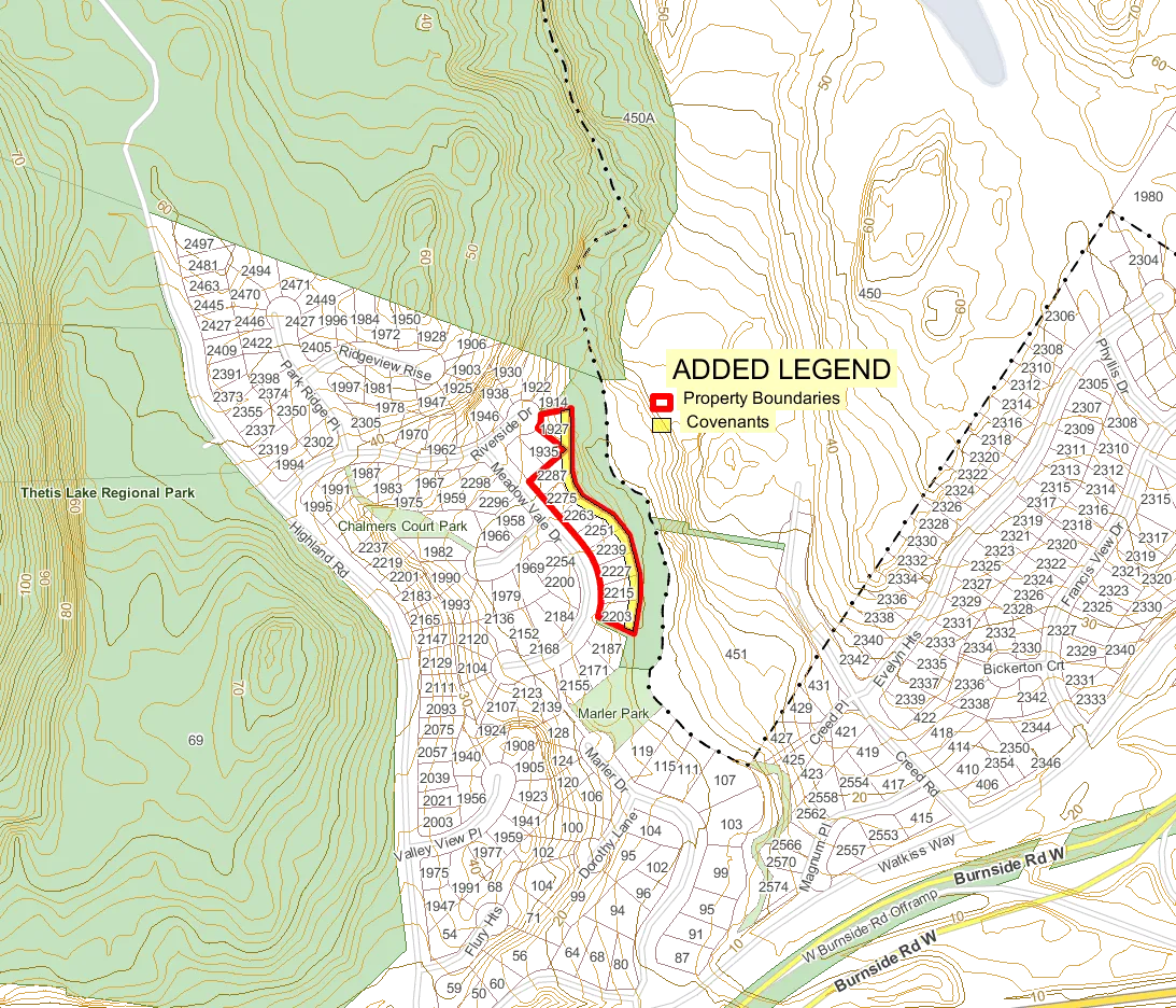
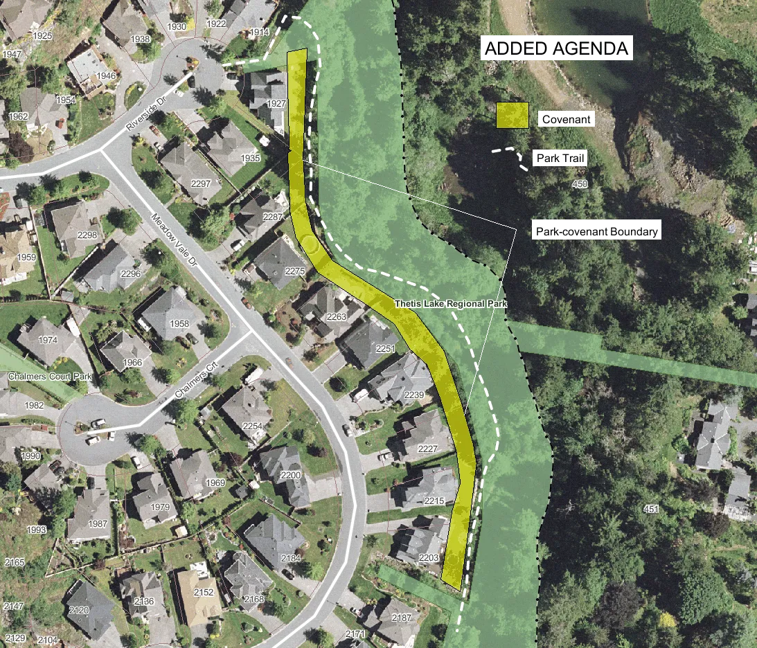
| 5. | Location - Approximate property and covenant locations are shown on a photo mosaic compiled using the Capital Regional District (CRD) Natural Areas Atlas (Attachment 1). Civic addresses - See item 2 above UTM Coordinates - • Northeast corner of Lot 8 - 466374, 5368272 • Southeast corner of Lot 18 - 466430, 5368083 |
| 6. | Covenant Sizes: Lot 8...0.175 ha; Lot 11...0.175 ha; Lot 12...0.163 ha; Lot 13...0.162 ha; Lot 14...0.167 ha; Lot 15...0.181 ha; Lot 16...0.161 ha; Lot 17...0.173 ha; Lot 18...0.173 ha. Total covenant area = 1.53 ha. |
|
| 7. | Topography | |
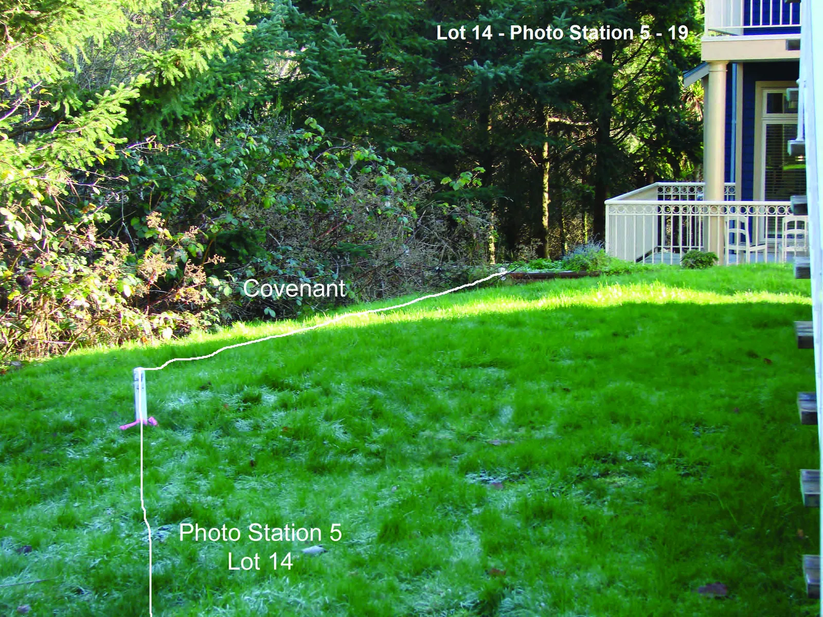
| Slope (horizontal : vertical ratio) ✔ 2:1-3:1...Lots 8 and 14 (½ of covenant is sloped); Lot 15 (All of the covenant is sloped) |
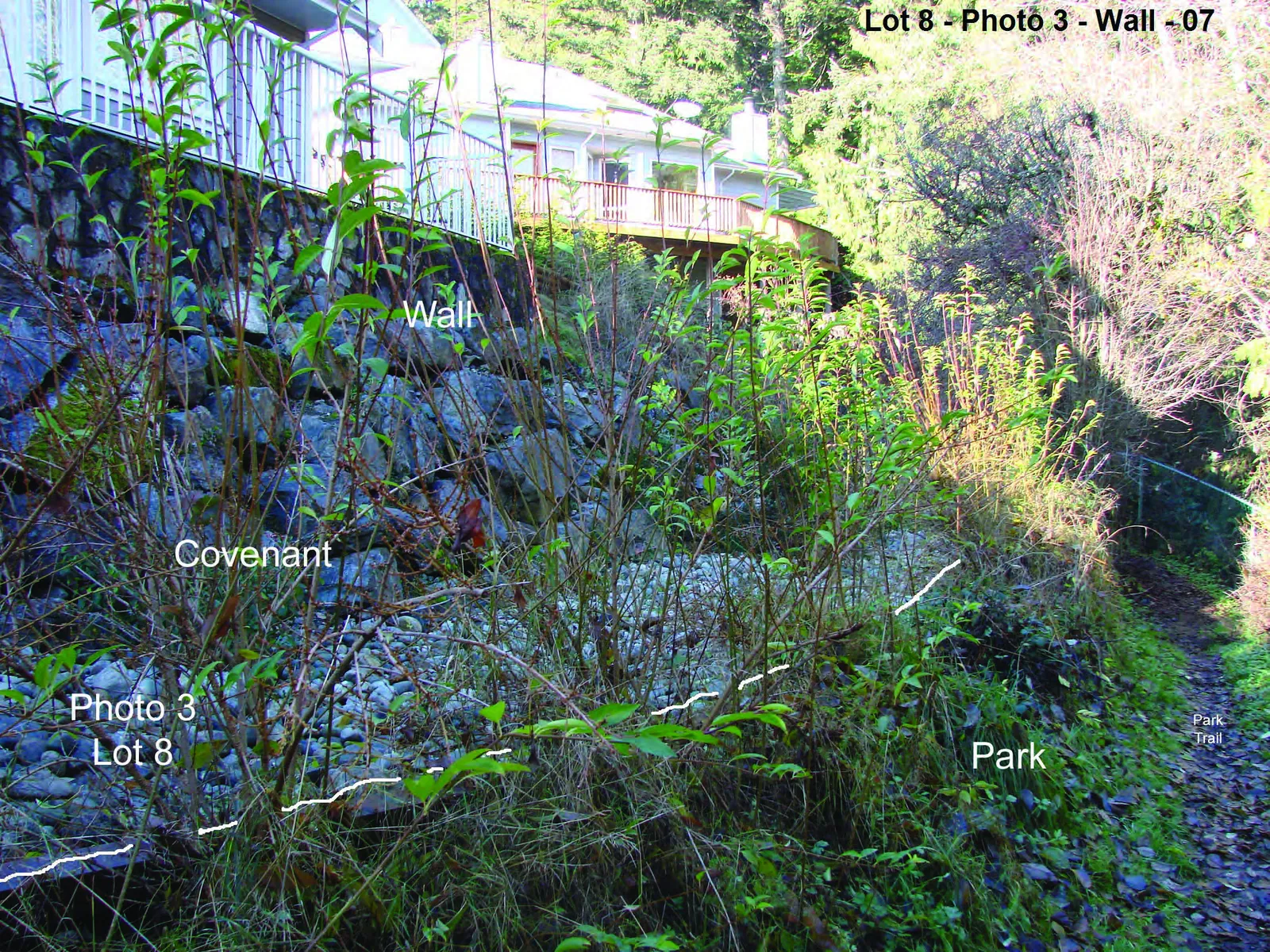
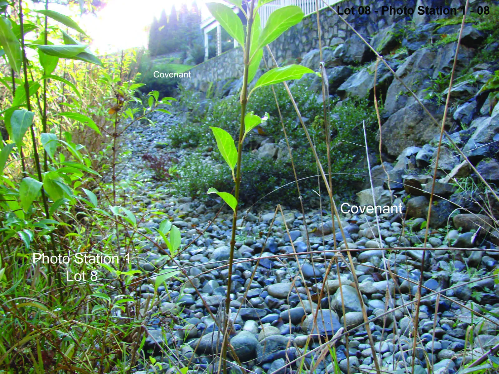
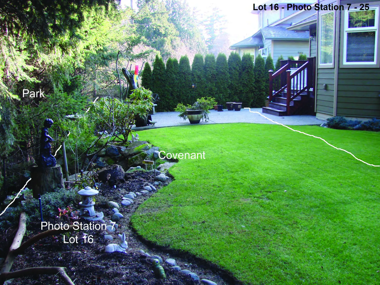
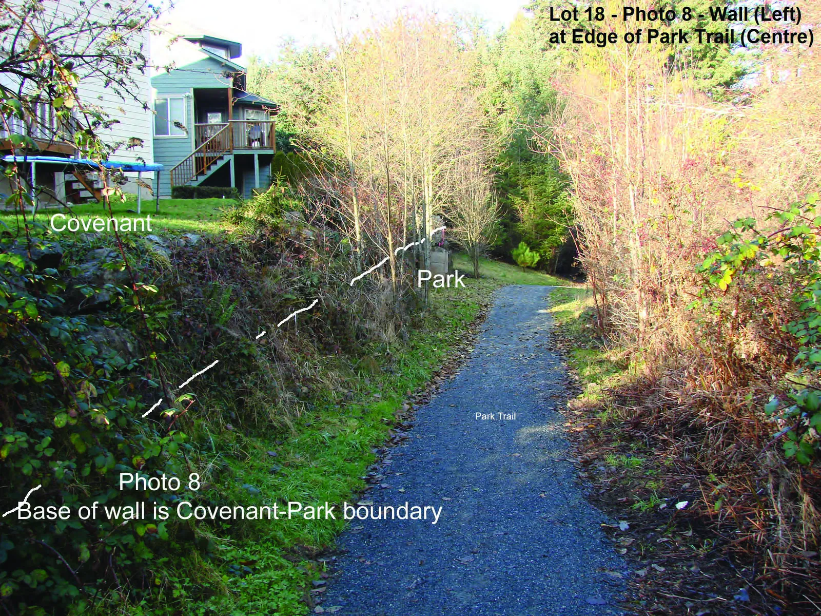
Terrain ✔ Flat...Lots 11, 12, 13, 16, 17 & 18 ✔ Lots 12, 13, 16, 17 & 18 have rock walls bordering the park; Lot 8 has a rock wall within the covenant. |
|
| Aspect E...Lots 8, 11, 12, S part of 15, 16 & N part of 17 NE...Lots 13, 14 & N part of 15 SE...Lots 18 and S part of 17 |
Elevation (m) ☐ Highest point - SE corner of Lot 8 and NE corner of Lot 11 = 19 m ☐ Lowest point - SE corner, Lot 18 = 11 m |
|
| 8. | Soils/Geology | |
| Surface ✔ Till - ca. 40% of treed portion of Lot 14 and ca. 80% of treed portion of Lot 15. ✔ Fill - 100% for all Lots except till covered treed portions of lots 14 & 15. |
✔ Disturbed - 100% for all Lots except where 10-15 year old forest covers portions of Lots 14 & 15. | |
| Soil texture ✔ Sandy-gravel with silt and boulders - 100% for all lots; stairways have been placed in Lots 16, 17 & 18. |
||
| 9. | The watershed in which the covenant is located and into which it drains is Craigflower Creek. | |
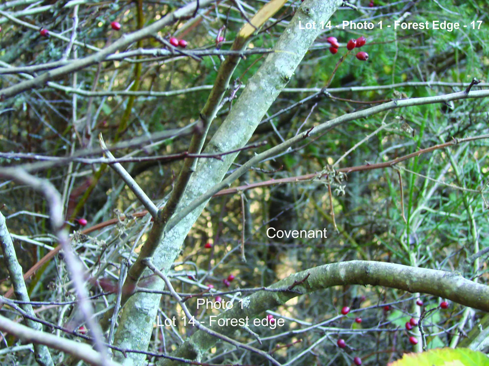
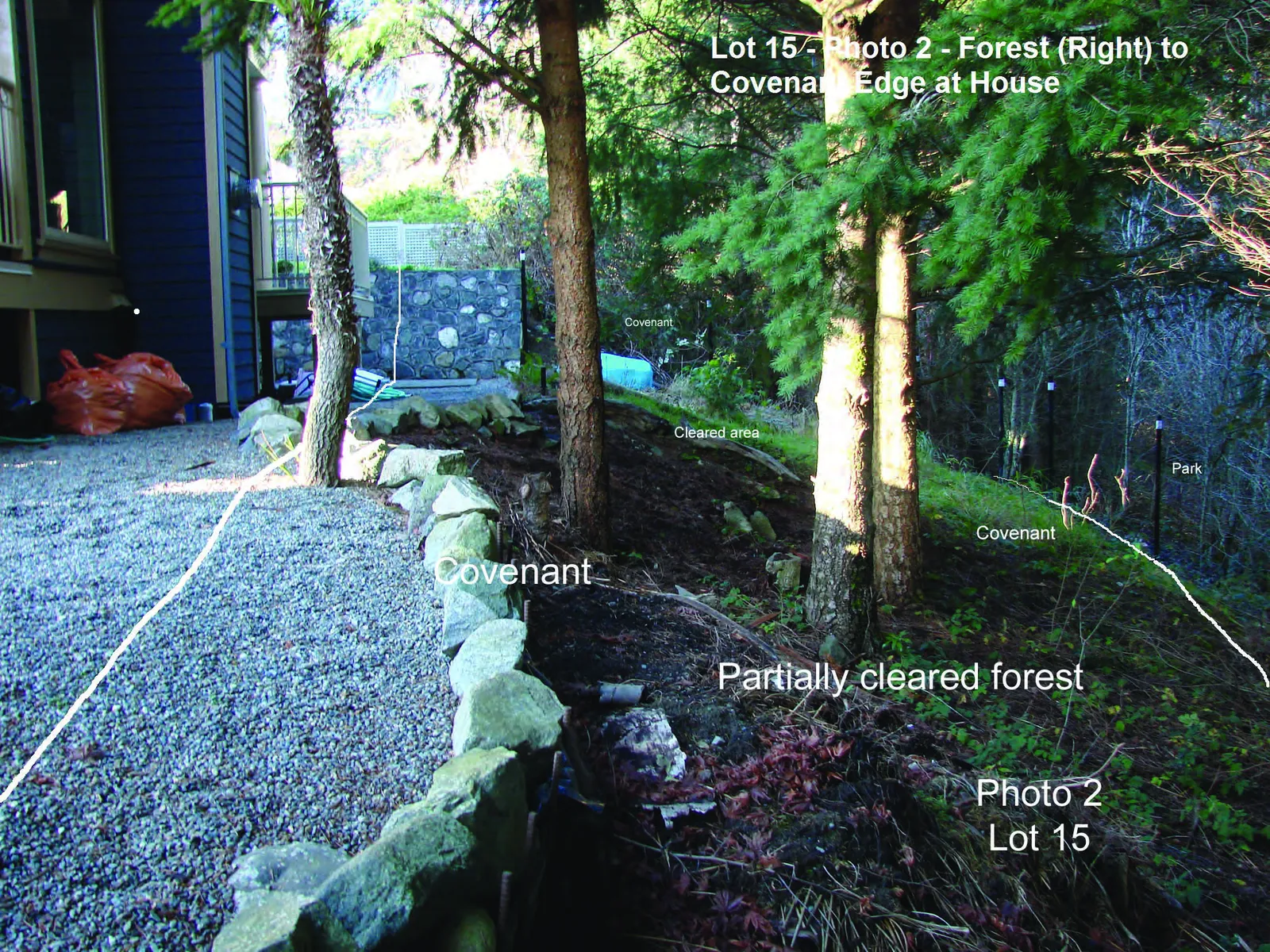
| 10. | Dominant ecosystems and/or plant community(ies) ☐ No Red-listed or Blue-listed ecosystems or plant communities were found in any part of the covenanted areas. Limited areas of 10-15 year old second growth, Coastal Douglas-fir that have been impacted by residential development were found within Lot 14 (Photo 1) and Lot 15 (Photo 2). |
| 11. | Watercourse(s)... located inside the covenanted area. Type Seasonal or Permanent # ✔ None |
Standing water... located inside the covenanted area. Type Seasonal or Permanent # ✔ None |
| 12. | Plants Observed - A table showing common and scientific names of plants observed is given in Attachment 2. Total # Red-listed species - 0 Total # Blue-listed species - 0 |
|
| 13. | Animals Observed - A table showing common and scientific names of animals observed is given in Attachment 3. Total Red-listed species - 0 Total Blue-listed species - 0 |
|
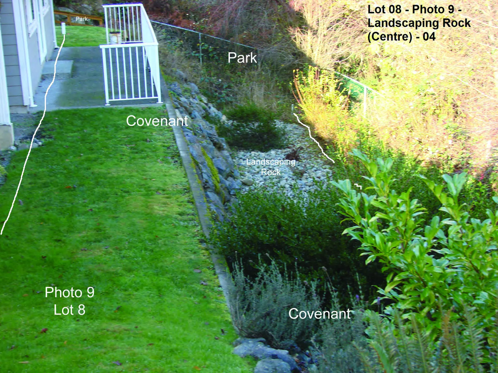
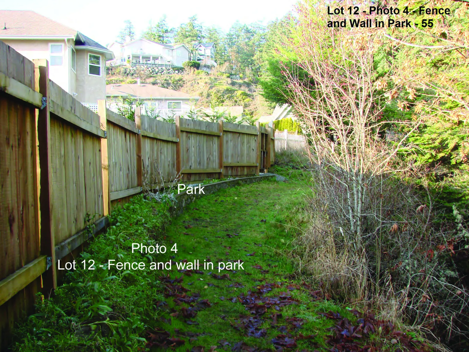
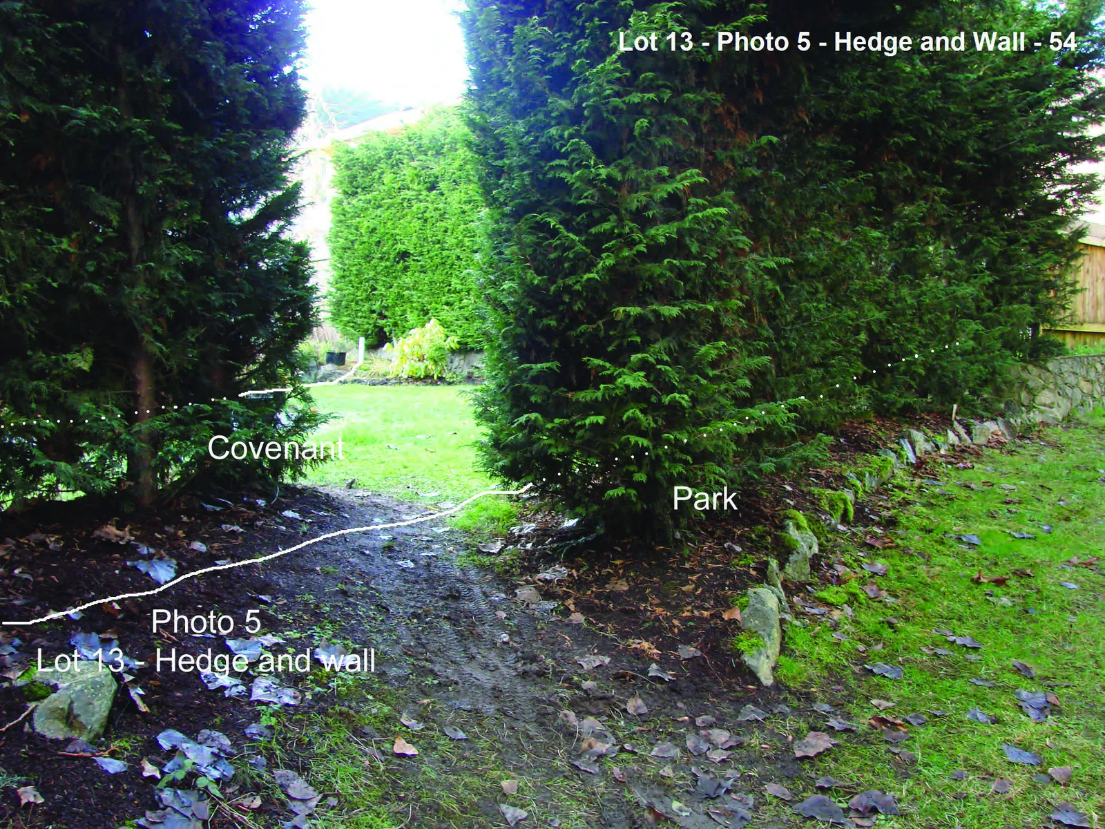
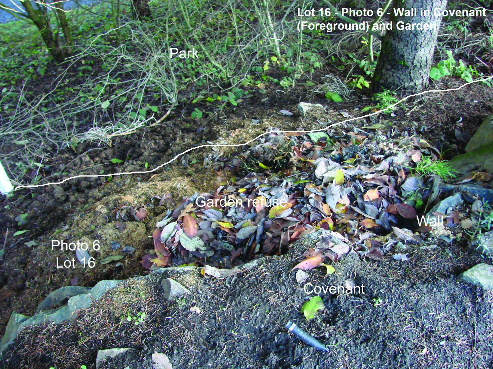
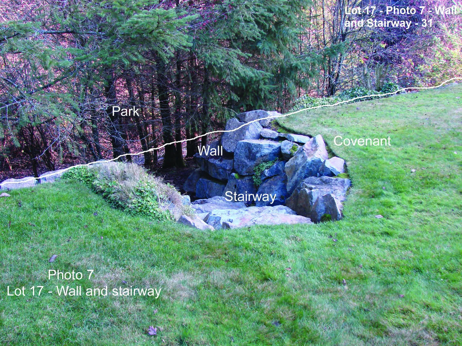
| 14. | Significant habitats observed The only habitats of note within the covenants that have potential value to amphibians, reptiles and invertebrates are the crevices and limited cover created by the placement of boulder walls in Lots 8 - Photo 3, 12 - Photo 4, 13 - Photo 5, 16 - Photo 6, 17 - Photo 7 and 18 - Photo 8. Landscaping rock found in Lot 8 (Photo 9) may provide limited habitat benefits to some invertebrates. |
|
| 15. | Protected Nests (i.e. includes nests of Eagle, Peregrine Falcon, Gyr Falcon, Osprey, Heron and Burrowing Owl). Locations - As shown in the photo mosaic drawing prepared using the CRD Natural Areas Atlas in Attachment 4, no protected nests were observed. Number Observed - NIL |
|
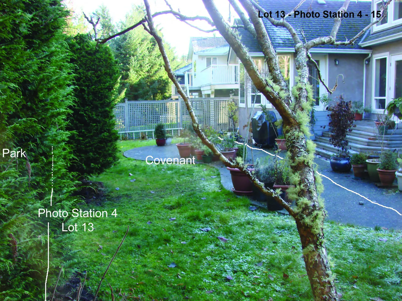
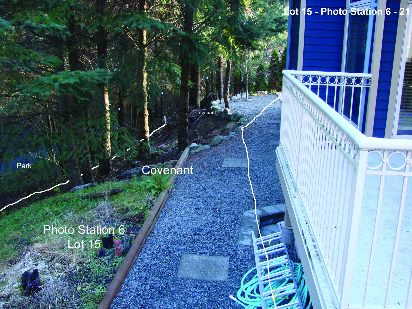
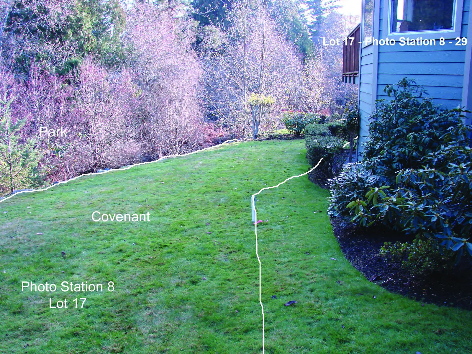
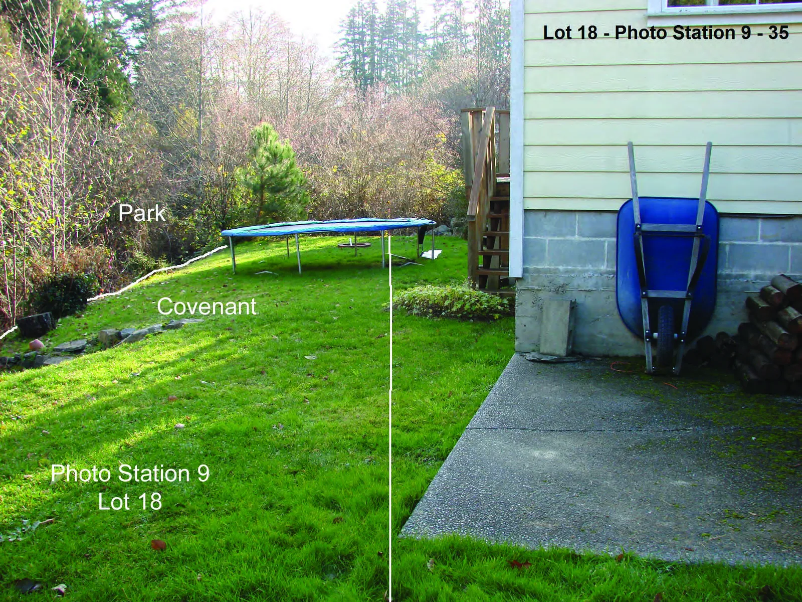
| 16. | Historic Impacts (see section 17 - photo station pictures) Human caused ✔ Residential developments in all lots have encroached significantly into the covenanted area. ✔ Covenanted areas in all lots contained Temporary and/or permanent structures. |
Natural ✔ No natural impacts were observed. |
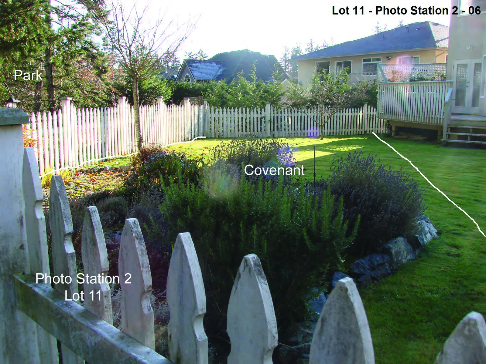
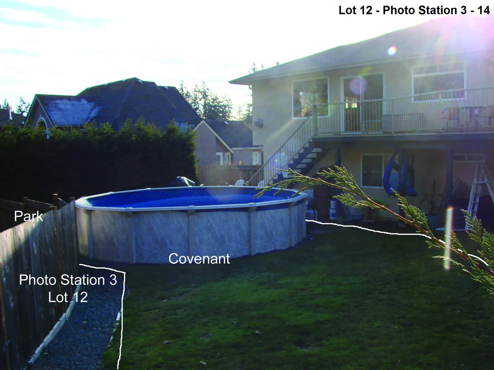
| 17. | Photo stations • One photo station was established for each lot containing a covenant. • Each photo station was located at a point where a steel pin was placed earlier by Island Land Surveying Ltd. as part of their survey of covenant boundaries on behalf of the Town. • Photo stations were located at survey pins at the NE corners of Lots 8 (Photo Station 1), 11 (Photo Station 2), 12 (Photo Station 3), 13 (Photo Station 4) and 16 (Photo Station 7), as well as at survey pins at the NW corners of Lots 14 (Photo Station 5), 15 (Photo Station 6), 17 (Photo Station 8) and 18 (Photo Station 9). • The general locations of each photo station, the number assigned each photograph taken at each photo station (station photos 1 to 18) and the direction in which each photograph was taken are depicted on a photo mosaic drawing created using the Natural Areas Atlas at the CRD website (Attachment 5). |
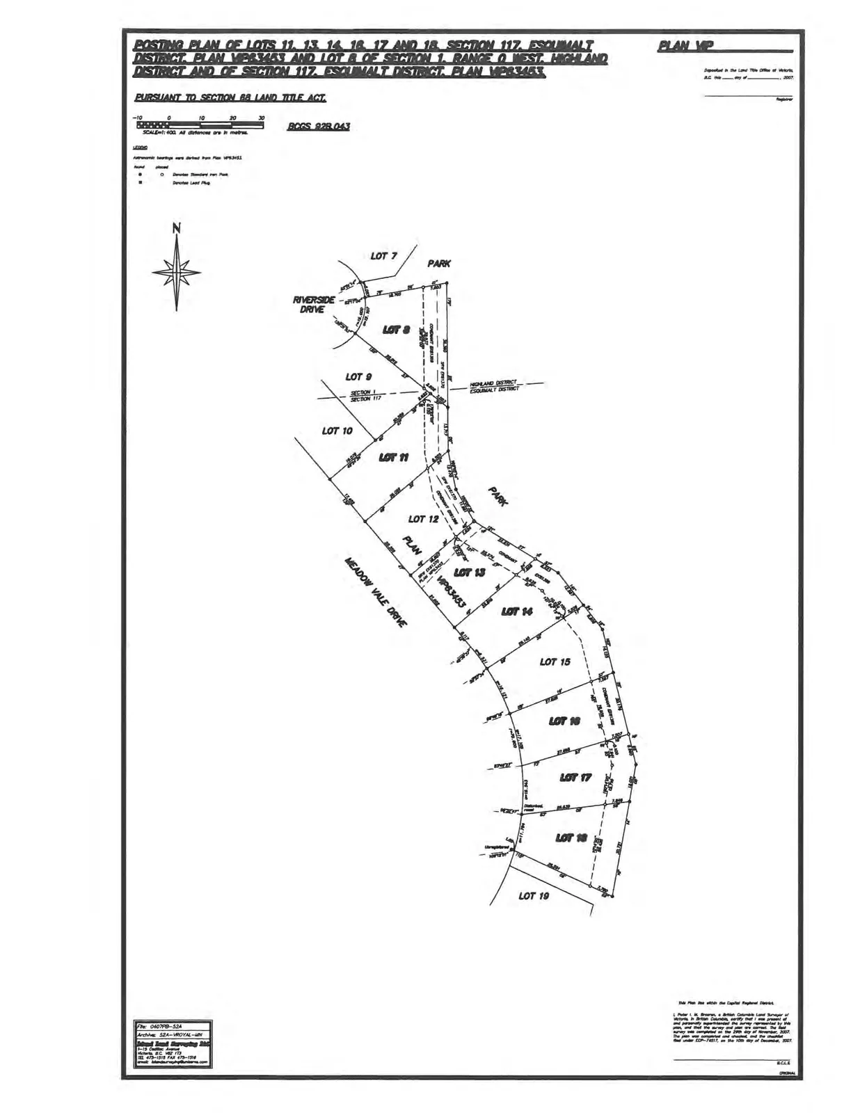
| 18. | Covenant boundaries Attachment 6 depicts the approximate boundary of the covenant for all 9 lots as an overlay on a photo mosaic base available from the CRD Natural Areas Atlas. A copy of the drawing showing each lot and associated pin locations that was prepared by Island Land Surveying Ltd. and posted at the Land Title Office is given in Attachment 7. |
| 19. | Opinions and observations - 1. All self-sustaining, native vegetation has been removed from all portions of the covenant except where regrowth of some native trees, shrubs, herbaceous plants, mosses and lichens has occurred in portions of Lots 14 and 15. 2. We believe the terrain, soils and drainage in all lots have been altered significantly and that there are no unmodified ecosystems or plant communities present, except to a limited extent in portions of the covenant in Lot 14 and Lot 15. 3. We believe that the natural values of all parts of the covenant have been lost to the impacts of historic residential development and ongoing residential use. 4. It is our opinion that the covenant cannot be restored to- or maintained in- a natural state given; • the locations of houses and other permanent structures adjoining or within the covenant, • the intensity of significant, ongoing residential use in the covenant, and • our understanding of the standards for fire safety adjacent to residential developments employed by the Town (i.e. 10 m wide zone free of significant natural fuels). |
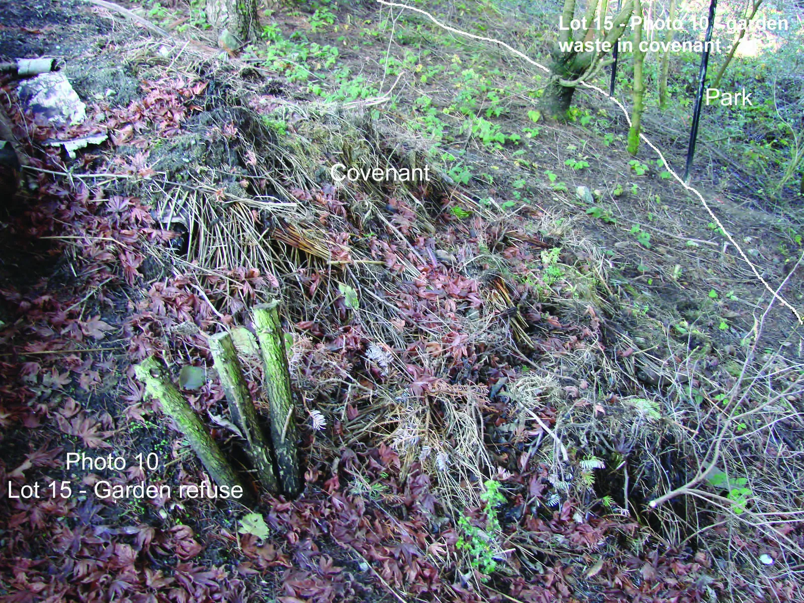
- Garden refuse was found deposited in a portion of the park (Lot 16 - see Photo 6) and in a portion of the covenant (i.e. Lot 15 - Photo 10).
- Structures and materials placed within the covenant included: rock walls (Lots 8, 12, 13, 14, 16, 17 and 18); landscaping rock (Lots 8 and 15); swimming pool (Lot 12); sundecks (Lots 11, 12, 16 and 17); stairways (Lots 16, 17 and 18); fences (Lots 11, 12 and 15); and hedges (Lots 12, 13 and 16).
Recommendations -
- The Town should remove the natural area covenant registered against all lots along the east side of Riverside Drive and Meadowvale Drive that adjoin Thetis Lake Regional Park following consultation with the property owners affected and with their agreement.
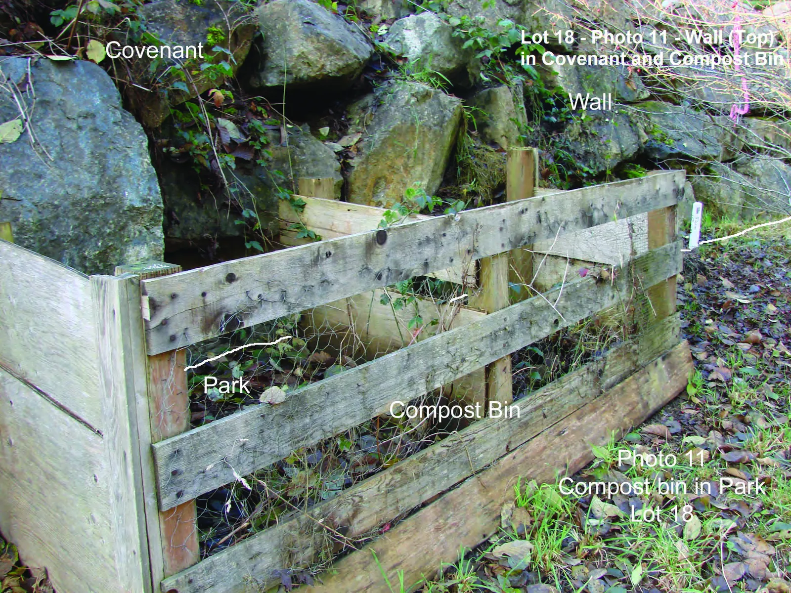
- The Town should advise CRD Parks of the encroachments by property owners into Thetis Lake Regional Park so that the CRD may consider appropriate action (i.e. Lot 12...wall and fence - Photo 11; Lot 18...compost bin - Photo 12).
20. Inspection report and photograph quality
A copy of this inspection report has been submitted to the Engineering Technologist, Engineering Department, Town of View Royal on a compact disc in PDF format and in WordPerfect format. That submission included all attachments and photographs.
Captions overlaying photographs were prepared using Adobe Photoshop Elements (Version 2).
21. Copyright and indemnification
All inspection reports completed at the request of the Town of View Royal (Town) or its agents remain the copyright property of the Town. The Town may authorize the person(s) who have prepared an inspection report (i.e. consultant) or other persons to make and distribute copies of a report. The consultant, or any other person, may not give, lend, sell or otherwise make an inspection report, or any portion of an inspection report, available to any party without the written permission of the Town.
Any use not authorized by the Town that a third party makes of an inspection report or any portion of an inspection report is the sole responsibility of such third parties. The Town or a consultant retained by the Town accept no responsibility for damages suffered by any third party resulting from use of an inspection report that has not been authorized by the Town.
Attachment 1 - Meadowvale Drive - Property Locations and Covenant Boundaries
ATTACHMENT 2
Observed Plants within covenants at Meadowvale Drive and Riverside Drive on November 30, 2007.
| # | Scientific Name | Common Name | Location and Comments |
|---|---|---|---|
| TREES | |||
| 1. | Pseudotsuga menziesii | Douglas-fir | - Location: Lots 8 (1 tree), 14 and 15 - Comment: Native |
| 2. | Thuja plicata | Western Redcedar | - Location: Lot 15 - Comment: Native |
| 3. | Thuja occidentalis | American Arbor vita (Hedge) | - Location: Lot 16 - Comment: Natives |
| 4. | Cupressocyparis leylandii | Leyland Cypress | - Location: Hedge in Lots 12, 13 (part of hedge in park), - Comment: Cultivated species |
| 5. | Alnus rubra | Red Alder | - Location: Lot 14, - Comment: Native |
| 6. | Ilex aquifolium | Holly | - Location: Lot 15 - Comment: Introduced-invasive |
| 7. | Prunus emarginata | Bitter Cherry | - Location: 2 in covenant 2. - Comment: Native |
| 8. | Crataegus monogyna | Common Hawthorn | - Location: Lot 8, 14, 15, - Comment: Cultivated species |
| 9. | Prunus sp. | Flowering Cherry | - Location: Lot 11, 16, 17 - Comment: Cultivated species |
| 10. | Picea sp. | Spruce (Small) | - Location: Lot 18 - Comment: Cultivated species |
| 11. | Cornus sp. | Flowering Dogwood | - Location: Lot 11 - Comment: Cultivated species |
| SHRUBS | |||
| 12. | Osmanthus heterophyllus | Holly Osmanthus | - Location: Lot 8 - Comment: Cultivated species |
| 13. | Rhododendron sp. | Rhododendron | - Location: Lot 11, 13, 16, 18 - Comment: Cultivated species |
| 14. | Pinus sp. | 2 needle ornamental pine | - Location: Lot 18 - Comment: Cultivated species |
| 15. | Viburnum tinus | Laurustinus | Location: Lot 8 Comment: Cultivated species |
| 16. | Erica sp. | Heather | Location: Lot 13, Comment: Cultivated species |
| 17. | Sasa veitchii | Bamboo | Location: Lot 16, Comment: Cultivated species |
| 18. | Syringa sp. | Lilac | - Location: Lot 18 - Comment: Cultivated species |
| 19. | Buddleja sp. | Butterfly Bush | - Location: Lot 18 - Comment: Cultivated species |
| 20. | Magnolia sp. | Magnolia | - Location: Lot 16 - Comment: Cultivated species |
| 21. | Acer palmatum | Japanese Cherry | - Location: Lot 18 - Comment: Cultivated species |
| 22. | Daphne laureola | Spurge Laurel | Location: Lot 15, 18 Comment: Introduced-invasive |
| 23. | Rhus | Staghorn Sumac | Location: Lot 13 Comment: Cultivated species |
| 24. | Prunus laurocerasus | Cherry Laurel | Location: Lot 8. Comment: Cultivated species |
| 25. | Rubus ursinus | Trailing Blackberry | Location: Lot 15, 18 (wall) Comment: Native |
| 26. | Rubus discolor | Himalayan Blackberry | Location: Lot 8, 14, 15, Comment: Introduced-invasive |
| 27. | Forsythia sp. | Forsythia | Location: Lot 8 Comment: Cultivated species |
| 28. | Rosa nutkana | Nootka Rose | Location: Lot 8. Comment: Native |
| 29. | Photinia sp. | Photinia | Location: Lot 18 Comment: Cultivated species |
| 30. | Oemleria cerasiformis | Indian-plumb | Location: Lot 15 Comment: Native |
| 31. | Holodiscus discolor | Ocean Spray | Location: Lot 8. Comment: Native |
| 32. | Symphoricarpos albus | Snowberry | Location: Lot 8 Comment: Native |
| 33. | Salix | Contorted Willow | Location: Lot 8 Comment: Cultivated species |
| 34. | Ceanothus sp. | California Lilac | Location: Lot 8, 17 Comment: Cultivated species |
| 35. | Hedera helix | English Ivy | Location: Lot 17 (On rock wall) Comment: Introduced-invasive |
| 36. | Nandina domestica | False Bamboo | Location: Lot 11. Comment: Cultivated species |
| 37. | Cytisus scoparius | Scotch Broom | Location: Lot 14 Comment: Introduced-invasive |
| FORBS | |||
| 38. | Vinca minor | Small-leaved Periwinkle | Location: Lot 8 Comment: Cultivated-invasive |
| 39. | Sedum sp. | Ice Plant | Location: Lot 18 (wall) Comment: Cultivated species |
| 40. | Thymus sp. | Thyme | Location: Lot 11, 18 Comment: Cultivated species |
| 41. | Crocosmia sp. | Montbretia Lily | Location: Lot 11 Comment: Cultivated species |
| 42. | Lavandula sp. | Lavender | Location: Lot 8, 11 Comment: Cultivated species |
| 43. | Achillea millefolium | Yarrow (Cultivated form) | Location: Lot 11 Comment: Native |
| 44. | Salvia sp. | Sage | Location: Lot 11 Comment: Cultivated species |
| 45. | Stachys sp. | Lamb’s ears | Location: Lot 11 Comment: Cultivated species |
| 46. | Mentha sp. | Mint | Location: Lot 14, 18 Comment: Cultivated species |
| 47. | Iris sp. | Flags | Location: Lot 11, 16 Comment: Cultivated species |
| 48. | Ranunculus occidentalis | Western Buttercup | Location: Lot 8, 14, 18 Comment: Native |
| 49. | Fuchsia sp. | Fuchsia | Location: Lot 16 Comment: Cultivated species |
| 50. | Aster sp. | Aster | Location: Lot 11 Comment: Cultivated species |
| 51. | Argyranthemum sp. | Marguerite | Location: Lot 11 Comment: Cultivated species |
| 52. | Cirsium arvense | Canada Thistle | Location: Lot 8, 14, 15, Comment: Introduced-invasive |
| 53. | Hypochaeris radicata | Hairy Cat’s-ear | Location: Lot 8, Comment: Introduced-invasive |
| 54. | Taraxacum officinale | Common Dandelion | Location: Lot 8 Comment: Introduced-invasive |
| 55. | Digitalis purpurea | Common Foxglove | Location: Lot 8 Comment: Native |
| 56. | Epilobium sp. | Willow Herb | Location: Lot 15 Comment: Native |
| 57. | Rumex crispa | Curled Dock | Location: Lot 15 Comment: Introduced-invasive |
| 58. | Rumex occidentalis | Western Dock | Location: Lot 15 Comment: Native |
| FERNS | |||
| 59. | Polystichum sp. | Sword Fern-type | Location: Lot 8 Comment: Cultivated species |
| 60. | Polystichum munitum | Sword Fern | Location: Lot 8, 17 (in rock work) Comment: Native |
| GRASSES | |||
| 61. | Dactylis glomerata | Orchard Grass | Location: Lot 8, 14, 15, 18 Comment: Introduced-invasive |
| 62. | Lolium sp. | Ryegrass | Location: Lot 15. Comment: Native |
| MOSSES | |||
| 63. | Isothecium myosuroides | Cat-tail Moss | Location: All Lots Comment: Native |
ATTACHMENT 3
Observed animals at covenants along Meadowvale Drive and Riverside Drive on November 30, 2007.
| # | Scientific Name | Common Name | Location and Comments |
|---|---|---|---|
| Mammals | |||
| 1. | Odocoileus hemionus ssp. columbianus | Mule (Black-tailed) Deer | - Location: Droppings in park near lots 8, 14 and 15 - Comment: native species |
| Birds | |||
| 2. | Junco oreganus | Oregon Junco | Location: Park beside Lot 8 Comment: Native species |
| 3. | Melospiza melodia | Song Sparrow | - Location: Park beside Lot 8 - Comment: native species |
| 4. | Pipilo erythrophthalmus | Rufous-sided Towhee | - Location: Park beside Lot 8 - Comment: Native species |
| 5. | Vireo huttoni | Hutton’s Vireo | - Location: Park beside Lot 8 - Comment: native species |
| Invertebrates | |||
| 6. | Formica sp. | Wood Ant | - Location: One hill in park beside Lot 11 - Comment: native species |
Attachment 4 - Meadowvale Drive - No Protected Trees Observed
Attachment 5 - Meadowvale Drive Photo Stations - Locations and Numbers
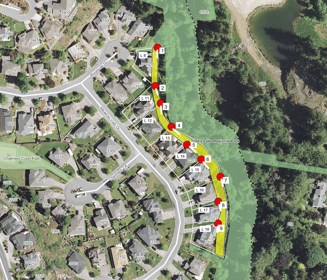
Attachment 6 - Meadowvale Drive - Approximate property and covenant boundaries
Attachment 7
Document Images
(6)