Council Report: DEVELOPMENT PERMIT APPLICATION- 1649 LLOYD PLACE
A staff report recommending the approval of a development permit for ten units of attached housing, including several height and parking variances.
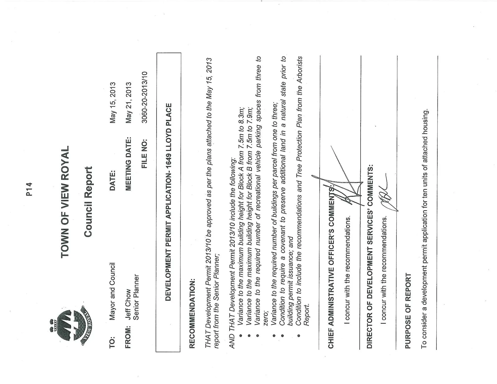
TOWN OF VIEW ROYAL
Council Report
TO: Mayor and Council DATE: May 15, 2013 FROM: Jeff Chow, Senior Planner MEETING DATE: May 21, 2013 FILE NO: 3060-20-2013/10
DEVELOPMENT PERMIT APPLICATION- 1649 LLOYD PLACE
RECOMMENDATION:
THAT Development Permit 2013/10 be approved as per the plans attached to the May 15, 2013 report from the Senior Planner;
AND THAT Development Permit 2013/10 include the following:
- Variance to the maximum building height for Block A from 7.5m to 8.3m;
- Variance to the maximum building height for Block B from 7.5m to 7.9m;
- Variance to the required number of recreational vehicle parking spaces from three to zero;
- Variance to the required number of buildings per parcel from one to three;
- Condition to require a covenant to preserve additional land in a natural state prior to building permit issuance; and
- Condition to include the recommendations and Tree Protection Plan from the Arborists Report.
CHIEF ADMINISTRATIVE OFFICER'S COMMENTS: I concur with the recommendations.
DIRECTOR OF DEVELOPMENT SERVICES' COMMENTS: I concur with the recommendations.
PURPOSE OF REPORT
To consider a development permit application for ten units of attached housing.
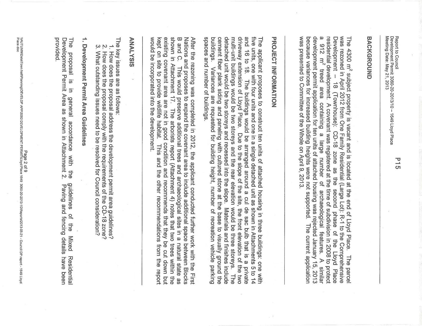
BACKGROUND
The 4300 m² subject property is vacant and is located at the end of Lloyd Place. The parcel was rezoned in April 2012 from One Family Residential (Large Lot): R-1 to the Comprehensive Development - 18 (Townhouse): CD-18 zone as the second phase of the Lloyd Place residential development. A covenant was registered at the time of subdivision in 2008 to protect a 912 m² treed area containing a large number of archaeological features. A similar development permit application for ten units of attached housing was rejected January 15, 2013 because variances for increased building heights were not supported. The current application was presented to Committee of the Whole on April 9, 2013.
PROJECT INFORMATION
The applicant proposes to construct ten units of attached housing in three buildings: one with five units, one with four units and one in a single detached unit as shown in Attachments 5 to 14 and 16 to 18. The buildings would be arranged around a cul de sac bulb that is a private driveway extension of Lloyd Place. Due to the slope of the site, the front elevation of the two multi-unit buildings would be two storeys and the rear elevation would be three storeys. The detached unit would be two storeys and recessed into the slope. Materials and finishes include cement fiber plank siding and paneling with cultured stone at the base to visually ground the buildings. Variances are requested for building height, number of recreation vehicle parking spaces and number of buildings.
After the rezoning was completed in 2012, the applicant conducted further work with the First Nations and proposes to expand the covenant area to include additional space between Blocks B and C. This would preserve additional trees and archaeological sites in a natural state as shown in Attachment 17. The arborists report (Attachment 4) notes that two trees within the existing covenant area are not in good condition and recommends that they be cut down but kept on site to provide wildlife habitat. This and the other recommendations from the report would be incorporated into the development.
ANALYSIS
The key issues are as follows:
- How does the proposal address the development permit area guidelines?
- How does the proposal comply with the requirements of the CD-18 zone?
- What outstanding issues need to be resolved for Council consideration?
1. Development Permit Area Guidelines
The proposal is in general accordance with the guidelines of the Mixed Residential Development Permit Area as shown in Attachment 2. Paving and fencing details have been provided.
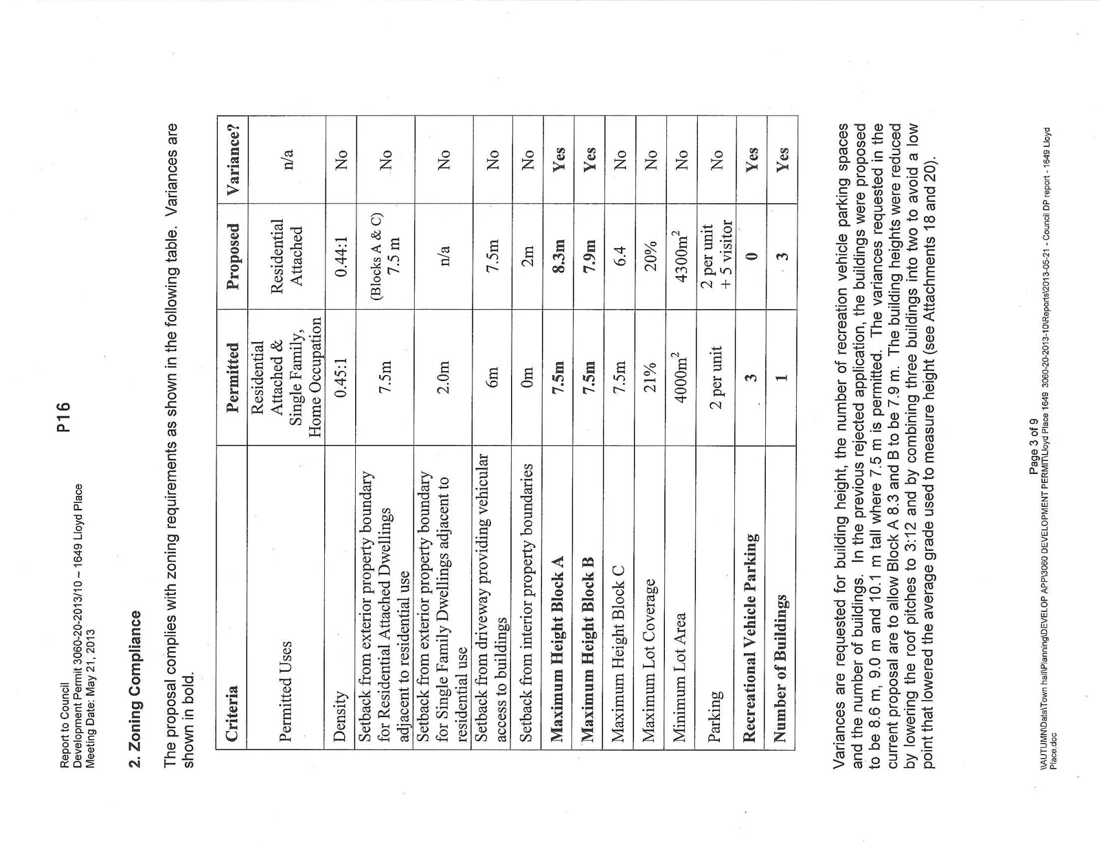
2. Zoning Compliance
The proposal complies with zoning requirements as shown in the following table. Variances are shown in bold.
| Criteria | Permitted | Proposed | Variance? |
|---|---|---|---|
| Permitted Uses | Residential Attached & Single Family, Home Occupation | Residential Attached | n/a |
| Density | 0.45:1 | 0.44:1 | No |
| Setback from exterior property boundary for Residential Attached Dwellings adjacent to residential use | 7.5m | (Blocks A & C) 7.5 m | No |
| Setback from exterior property boundary for Single Family Dwellings adjacent to residential use | 2.0m | n/a | No |
| Setback from driveway providing vehicular access to buildings | 6m | 7.5m | No |
| Setback from interior property boundaries | 0m | 2m | No |
| Maximum Height Block A | 7.5m | 8.3m | Yes |
| Maximum Height Block B | 7.5m | 7.9m | Yes |
| Maximum Height Block C | 7.5m | 6.4 | No |
| Maximum Lot Coverage | 21% | 20% | No |
| Minimum Lot Area | 4000m² | 4300m² | No |
| Parking | 2 per unit | 2 per unit + 5 visitor | No |
| Recreational Vehicle Parking | 3 | 0 | Yes |
| Number of Buildings | 1 | 3 | Yes |
Variances are requested for building height, the number of recreation vehicle parking spaces and the number of buildings. In the previous rejected application, the buildings were proposed to be 8.6 m, 9.0 m and 10.1 m tall where 7.5 m is permitted. The variances requested in the current proposal are to allow Block A 8.3 and B to be 7.9 m. The building heights were reduced by lowering the roof pitches to 3:12 and by combining three buildings into two to avoid a low point that lowered the average grade used to measure height (see Attachments 18 and 20).
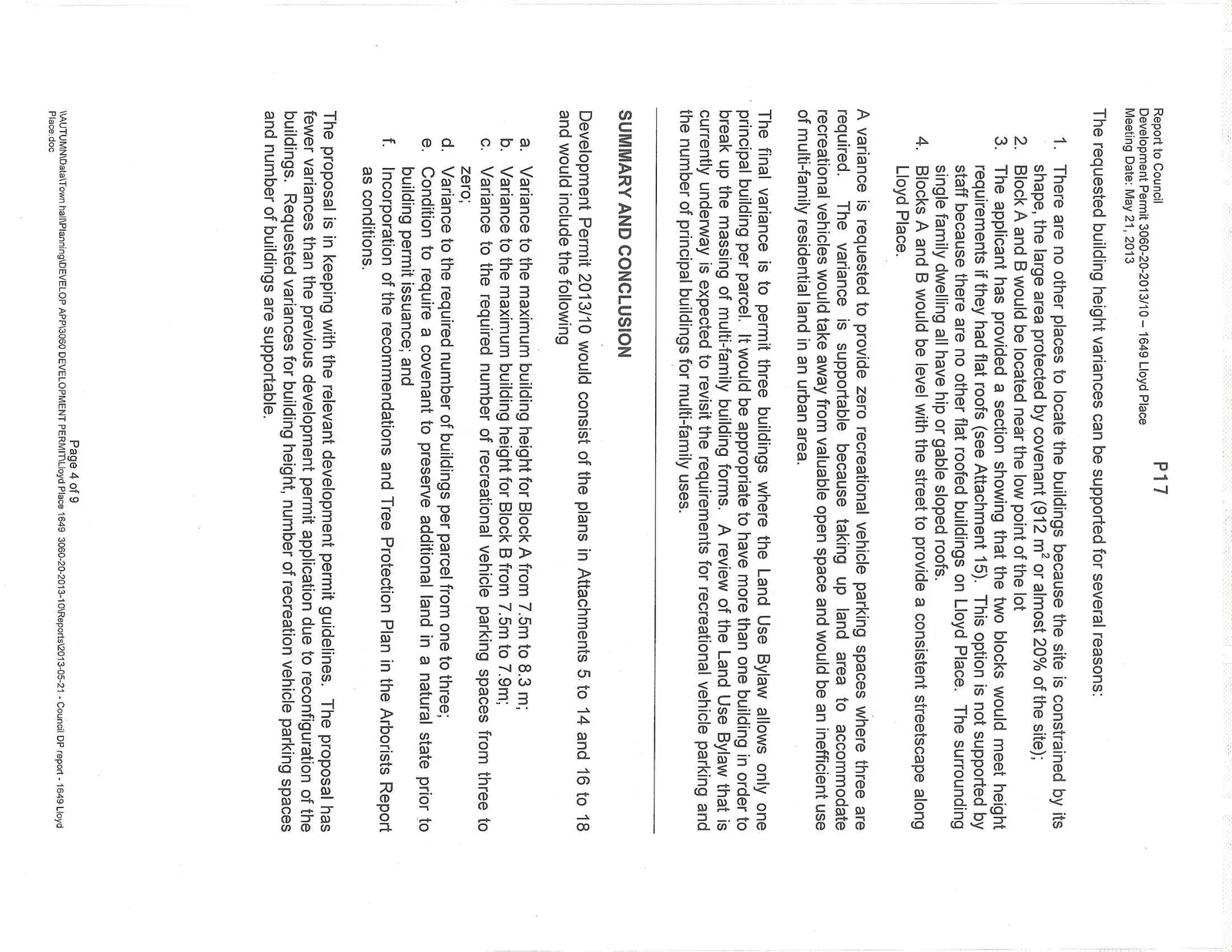
The requested building height variances can be supported for several reasons:
- There are no other places to locate the buildings because the site is constrained by its shape, the large area protected by covenant (912 m² or almost 20% of the site);
- Block A and B would be located near the low point of the lot
- The applicant has provided a section showing that the two blocks would meet height requirements if they had flat roofs (see Attachment 15). This option is not supported by staff because there are no other flat roofed buildings on Lloyd Place. The surrounding single family dwelling all have hip or gable sloped roofs.
- Blocks A and B would be level with the street to provide a consistent streetscape along Lloyd Place.
A variance is requested to provide zero recreational vehicle parking spaces where three are required. The variance is supportable because taking up land area to accommodate recreational vehicles would take away from valuable open space and would be an inefficient use of multi-family residential land in an urban area.
The final variance is to permit three buildings where the Land Use Bylaw allows only one principal building per parcel. It would be appropriate to have more than one building in order to break up the massing of multi-family building forms. A review of the Land Use Bylaw that is currently underway is expected to revisit the requirements for recreational vehicle parking and the number of principal buildings for multi-family uses.
SUMMARY AND CONCLUSION
Development Permit 2013/10 would consist of the plans in Attachments 5 to 14 and 16 to 18 and would include the following a. Variance to the maximum building height for Block A from 7.5m to 8.3 m; b. Variance to the maximum building height for Block B from 7.5m to 7.9m; c. Variance to the required number of recreational vehicle parking spaces from three to zero; d. Variance to the required number of buildings per parcel from one to three; e. Condition to require a covenant to preserve additional land in a natural state prior to building permit issuance; and f. Incorporation of the recommendations and Tree Protection Plan in the Arborists Report as conditions.
The proposal is in keeping with the relevant development permit guidelines. The proposal has fewer variances than the previous development permit application due to reconfiguration of the buildings. Requested variances for building height, number of recreation vehicle parking spaces and number of buildings are supportable.
ALTERNATIVE RECOMMENDATION
THAT Development Permit 2013/10 be approved as per the plans attached to the May 15, 2013 report from the Senior Planner that specify flat roofs for Buildings A and B;
AND THAT Development Permit 2013/10 include the following:
- Variance to the required number of recreational vehicle parking spaces from three to zero;
- Variance to the required number of buildings per parcel from one to three;
- Condition to require a covenant to preserve additional land in a natural state prior to building permit issuance; and
- Condition to include the recommendations and Tree Protection Plan from the Arborists Report.
This alternative recommendation would require all of the buildings to meet the 7.5m height requirement. Staff do not support this flat roof design because it would not be in keeping with adjacent neighbourhood.
ATTACHMENTS
- Location Map
- Review of Development Permit Area Guidelines (2 pages)
- Letter to Mayor & Council from Biki Kang, Kang & Gill Construction, March 5, 2013 (2 pages)
- Arborist Report – SouthShore Forest Consultants, August 8, 2012 (14 pages)
- Site Plan A-101 – Misra Architect, March 5, 2013
- Grade Calculations Block 'A, B & C' A-200-1 - Misra Architect, March 5, 2013
- Floor Plans Block 'A' A-201 - Misra Architect, March 5, 2013
- Floor Plans Block 'B' A-202 - Misra Architect, March 5, 2013
- 2nd Floor and Roof Plans Block 'B' A-203 - Misra Architect, March 5, 2013
- Plans and Elevations Block 'C' A-204 - Misra Architect, March 5, 2013
- Unit Plans A-205 - Misra Architect, March 5, 2013
- Elevations Block 'A' A-301 - Misra Architect, March 5, 2013
- Elevations Block 'B' A-302 - Misra Architect, March 5, 2013
- Building Sections with Sloped Roof A-401 - Misra Architect, March 5, 2013
- Building Sections A-401a - Misra Architect, March 5, 2013
- Colour Scheme C01 - Misra Architect, January 9, 2013
- Landscape Plan L1 – Lombard North Group, March 8, 2013
- (Servicing Plan) Drawing 12-196 Fig1 - McElhanney Consulting Services, March 11, 2013
- Site Plan A-101 (previous application) – Misra Architect, July 12, 2012
- Comparison of previous and current applications
RECOMMENDATION
THAT Development Permit 2013/10 be approved as per the plans attached to the May 15, 2013 report from the Senior Planner;
AND THAT Development Permit 2013/10 include the following:
- Variance to the maximum building height for Block A from 7.5m to 8.3m;
- Variance to the maximum building height for Block B from 7.5m to 7.9m;
- Variance to the required number of recreational vehicle parking spaces from three to zero;
- Variance to the required number of buildings per parcel from one to three;
- Condition to require a covenant to preserve additional land in a natural state prior to building permit issuance; and
- Condition to include the recommendations and Tree Protection Plan from the Arborists Report.
SUBMITTED BY: Jeff Chow, MCIP, RPP, Senior Planner REVIEWED BY: L. Chase, MCIP, RPP, Director of Development Services
Document Images
(6)