Attachment 4: SouthShore Forest Consultants Arborist Report
A detailed technical report regarding tree inventory, health, and protection strategies for the 1649 Lloyd Place site.
Arborist Report
The Woods - 1649 Lloyd Place Town Of View Royal
August 8, 2012
Prepared for Kang & Gill Construction LTD. 937 Dunford Avenue, Suite 105 Victoria, British Columbia V9B 2S4 Phone (250) 590-3140
Prepared by Michael Butcher SouthShore forest Consultants 10153 Resthaven Drive, Sidney B.C. V8L-3G7
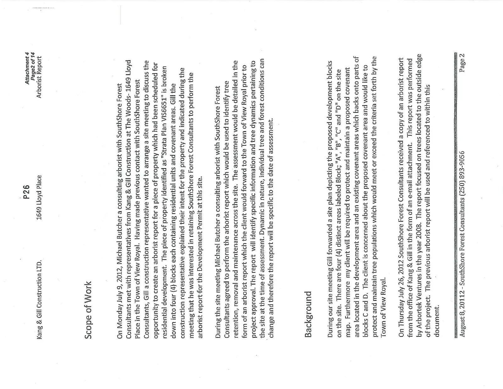
Scope of Work
On Monday July 9, 2012, Michael Butcher a consulting arborist with SouthShore Forest Consultants met with representatives from Kang & Gill Construction at The Woods- 1649 Lloyd Place in the Town of View Royal. Having made previous contact with SouthShore Forest Consultants, Gill a construction representative wanted to arrange a site meeting to discuss the opportunity to create an arborist report for a piece of property which had been scheduled for residential development. The piece of property identified as "Strata Plan VIS6651" is broken down into four (4) blocks each containing residential units and covenant areas. Gill the construction representative explained their intent for the property and indicated during the meeting that he was interested in retaining SouthShore Forest Consultants to perform the arborist report for the Development Permit at this site.
During the site meeting Michael Butcher a consulting arborist with SouthShore Forest Consultants agreed to perform the arborist report which would be used to identify tree retention, removal and maintenance across the site. The assessment would be detailed in the form of an arborist report which the client would forward to the Town of View Royal prior to project approval. The report will identify specific information and tree dynamics pertaining to the site at the time of assessment. Dynamic in nature, individual tree and forest conditions can change and therefore the report will be specific to the date of assessment.
Background
During our site meeting Gill forwarded a site plan depicting the proposed development blocks on the site. There are four (4) distinct areas labeled Block; "A", "B", "C" and "D" on the site map. Furthermore my client will be required to protect and maintain a proposed covenant area located in the development area and an existing covenant areas which backs onto parts of blocks C and D. The client is concerned about the proposed covenant area and would like to protect and maintain tree populations which would meet or exceed the criteria set forth by the Town of View Royal.
On Thursday July 26, 2012 SouthShore Forest Consultants received a copy of an arborist report from the office of Kang & Gill in the form of an e-mail attachment. This report was performed by Arbortek Ventures in the year 2008. The report focused on trees located to the outside edge of the project. The previous arborist report will be used and referenced to within this document.
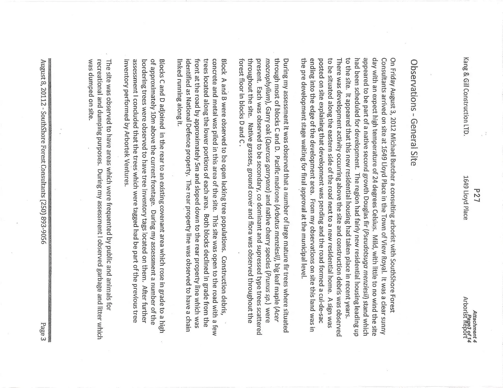
Observations - General Site
On Friday August 3, 2012 Michael Butcher a consulting arborist with SouthShore Forest Consultants arrived on site at 1649 Lloyd Place in the Town of View Royal. It was a clear sunny day with an expect high temperature of 24 degrees Celsius. Mild, with little to no wind the site appeared to be part of a native second growth Douglas fir (Pseudotsuga menziesii) stand which had been scheduled for development. The region had fairly new residential housing leading up to the site. It appeared that this new residential housing had taken place in recent years. There was development activity occurring above the site and construction debris was observed to be situated along the eastern side of the road next to a new residential home. A sign was posted on site explaining that development was pending and the road formed a cul-de-sac ending into the edge of the development area. From my observations on site this land was in the pre development stage waiting for final approval at the municipal level.
During my assessment it was observed that a number of large mature fir trees where situated through most of blocks C and D. Pacific madrone (Arbutus menziesii), big leaf maple (Acer macrophyllum), Garry oak (Quercus garryana) and native cherry species (Prunus sp.) were present. Each was observed to be secondary, co dominant and supressed type trees scattered throughout the site. Native grasses, ground cover and flora was observed throughout the forest floor in blocks D and C.
Block A and B were observed to be open lacking tree populations. Construction debris, concrete and metal was piled in this area of the site. This site was open to the road with a few trees located along the lower portions of each area. Both blocks declined in grade from the front at the road by approximately 5m and sloped down to the rear property line which was identified as National Defence property. The rear property line was observed to have a chain linked running along it.
Blocks C and D adjoined in the rear to an existing covenant area which rose in grade to a high of approximately 10m above the current frontage. During my assessment a number of the bordering trees were observed to have tree inventory tags located on them. After further assessment I concluded that the trees which were tagged had be part of the previous tree inventory performed by Arbortek Ventures.
The site was observed to have areas which were frequented by public and animals for recreational and dumping purposes. During my assessment I observed garbage and litter which was dumped on site.
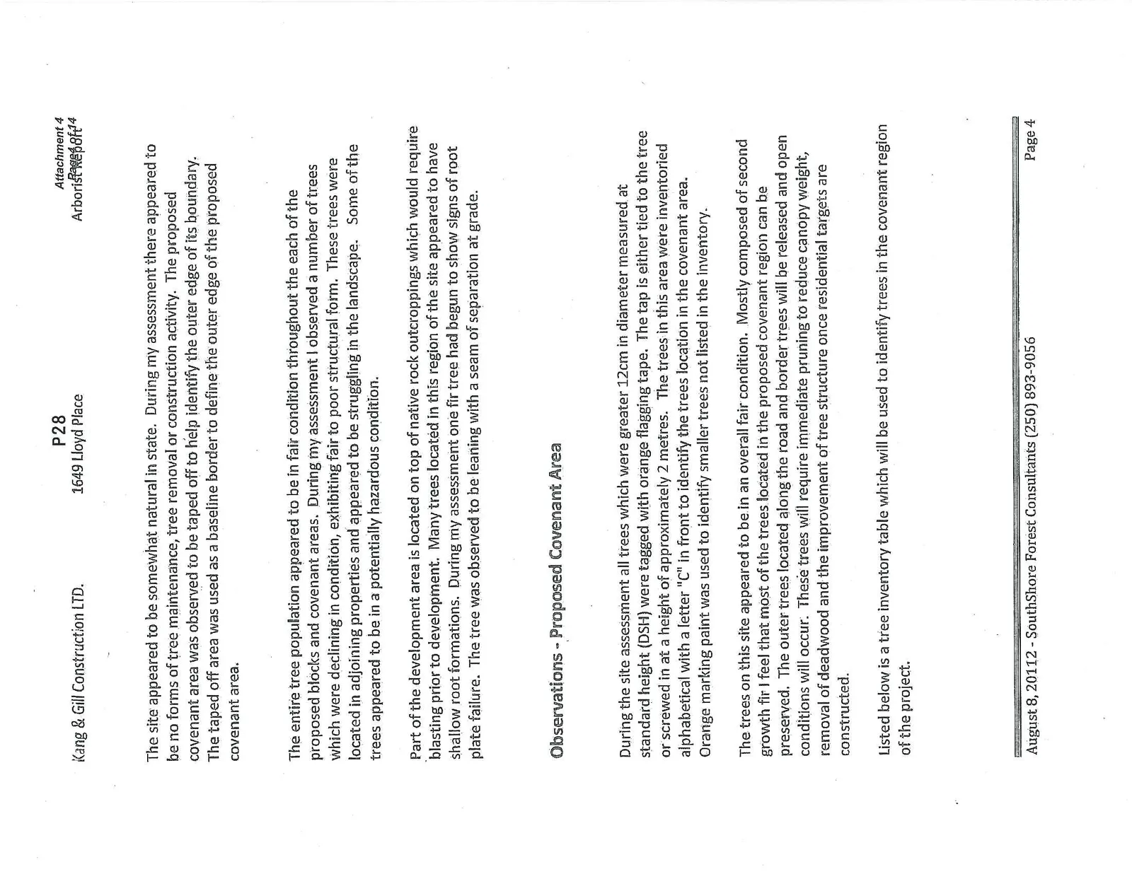
The site appeared to be somewhat natural in state. During my assessment there appeared to be no forms of tree maintenance, tree removal or construction activity. The proposed covenant area was observed to be taped off to help identify the outer edge of its boundary. The taped off area was used as a baseline border to define the outer edge of the proposed covenant area.
The entire tree population appeared to be in fair condition throughout the each of the proposed blocks and covenant areas. During my assessment I observed a number of trees which were declining in condition, exhibiting fair to poor structural form. These trees were located in adjoining properties and appeared to be struggling in the landscape. Some of the trees appeared to be in a potentially hazardous condition.
Part of the development area is located on top of native rock outcroppings which would require blasting prior to development. Many trees located in this region of the site appeared to have shallow root formations. During my assessment one fir tree had begun to show signs of root plate failure. The tree was observed to be leaning with a seam of separation at grade.
Observations - Proposed Covenant Area
During the site assessment all trees which were greater 12cm in diameter measured at standard height (DSH) were tagged with orange flagging tape. The tap is either tied to the tree or screwed in at a height of approximately 2 metres. The trees in this area were inventoried alphabetical with a letter "C" in front to identify the trees location in the covenant area. Orange marking paint was used to identify smaller trees not listed in the inventory.
The trees on this site appeared to be in an overall fair condition. Mostly composed of second growth fir I feel that most of the trees located in the proposed covenant region can be preserved. The outer trees located along the road and border trees will be released and open conditions will occur. These trees will require immediate pruning to reduce canopy weight, removal of deadwood and the improvement of tree structure once residential targets are constructed.
Listed below is a tree inventory table which will be used to identify trees in the covenant region of the project.
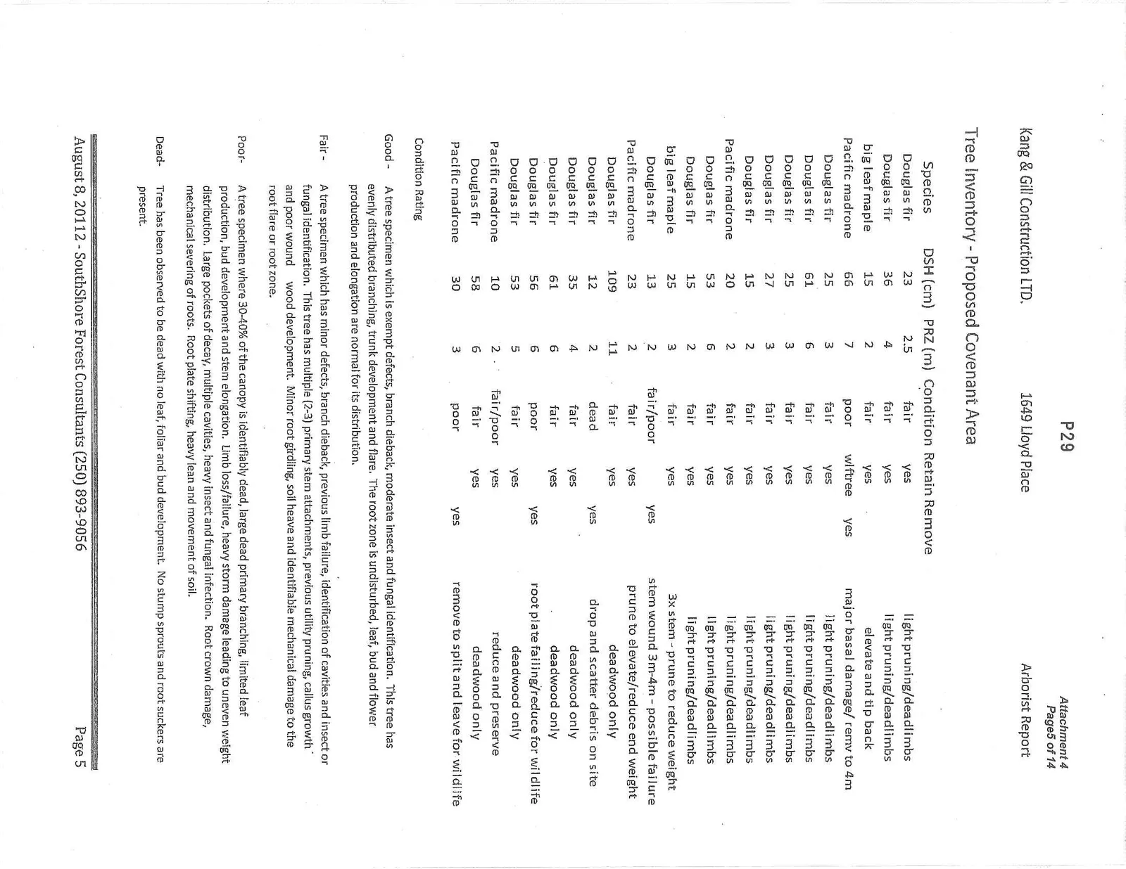
Tree Inventory - Proposed Covenant Area
| Species | DSH (cm) | PRZ (m) | Condition | Retain | Remove | Comments |
|---|---|---|---|---|---|---|
| Douglas fir | 23 | 2.5 | fair | yes | light pruning/deadlimbs | |
| Douglas fir | 36 | 4 | fair | yes | light pruning/deadlimbs | |
| big leaf maple | 15 | 2 | fair | yes | elevate and tip back | |
| Pacific madrone | 66 | 7 | poor | wlftree | yes | major basal damage/ remv to 4m |
| Douglas fir | 25 | 3 | fair | yes | light pruning/deadlimbs | |
| Douglas fir | 61 | 6 | fair | yes | light pruning/deadlimbs | |
| Douglas fir | 25 | 3 | fair | yes | light pruning/deadlimbs | |
| Douglas fir | 27 | 3 | fair | yes | light pruning/deadlimbs | |
| Douglas fir | 15 | 2 | fair | yes | light pruning/deadlimbs | |
| Pacific madrone | 20 | 2 | fair | yes | light pruning/deadlimbs | |
| Douglas fir | 53 | 6 | fair | yes | light pruning/deadlimbs | |
| Douglas fir | 15 | 2 | fair | yes | light pruning/deadlimbs | |
| big leaf maple | 25 | 3 | fair | yes | 3x stem - prune to reduce weight | |
| Douglas fir | 13 | 2 | fair/poor | yes | stem wound 3m-4m - possible failure | |
| Pacific madrone | 23 | 2 | fair | yes | prune to elevate/reduce end weight | |
| Douglas fir | 109 | 11 | fair | yes | deadwood only | |
| Douglas fir | 12 | 2 | dead | yes | drop and scatter debris on site | |
| Douglas fir | 35 | 4 | fair | yes | deadwood only | |
| Douglas fir | 61 | 6 | fair | yes | deadwood only | |
| Douglas fir | 56 | 6 | poor | yes | root plate failing/reduce for wildlife | |
| Douglas fir | 53 | 5 | fair | yes | deadwood only | |
| Pacific madrone | 10 | 2 | fair/poor | yes | reduce and preserve | |
| Douglas fir | 58 | 6 | fair | yes | deadwood only | |
| Pacific madrone | 30 | 3 | poor | yes | remove to split and leave for wildlife |
Condition Rating
- Good - A tree specimen which is exempt defects, branch dieback, moderate insect and fungal identification. This tree has evenly distributed branching, trunk development and flare. The root zone is undisturbed, leaf, bud and flower production and elongation are normal for its distribution.
- Fair - A tree specimen which has minor defects, branch dieback, previous limb failure, identification of cavities and insect or fungal identification. This tree has multiple (2-3) primary stem attachments, previous utility pruning, callus growth and poor wound wood development. Minor root girdling, soil heave and identifiable mechanical damage to the root flare or root zone.
- Poor - A tree specimen where 30-40% of the canopy is identifiably dead, large dead primary branching, limited leaf production, bud development and stem elongation. Limb loss/failure, heavy storm damage leading to uneven weight distribution. Large pockets of decay, multiple cavities, heavy insect and fungal infection. Root crown damage, mechanical severing of roots. Root plate shifting, heavy lean and movement of soil.
- Dead - Tree has been observed to be dead with no leaf, foliar and bud development. No stump sprouts and root suckers are present.
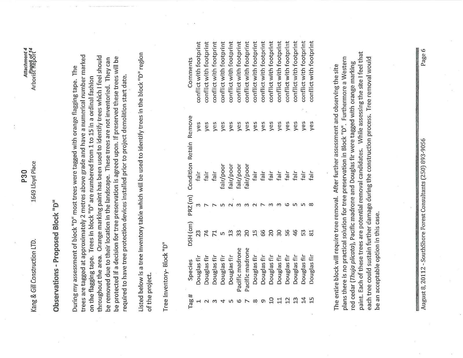
Observations - Proposed Block "D"
During my assessment of block "D" most trees were tagged with orange flagging tape. The trees are tagged at approximately 2 metres above grade and have a numerical number marked on the flagging tape. Trees in block "D" are numbered from 1 to 15 in a ordinal fashion throughout the area. Orange marking paint has been used to identify trees which I feel should be removed due to their location in the landscape. These trees are not inventoried. They can be protected if a decision for tree preservation is agreed upon. If preserved these trees will be required to have tree protection devices installed prior to project demolition start date.
Listed below is a tree inventory table which will be used to identify trees in the block "D" region of the project.
Tree Inventory- Block "D"
| Tag # | Species | DSH (cm) | PRZ (m) | Condition | Retain | Remove | Comments |
|---|---|---|---|---|---|---|---|
| 1 | Douglas fir | 23 | 3 | fair | yes | conflict with footprint | |
| 2 | Douglas fir | 74 | 7 | fair | yes | conflict with footprint | |
| 3 | Douglas fir | 71 | 7 | fair | yes | conflict with footprint | |
| 4 | Douglas fir | 5 | 5 | fair/poor | yes | conflict with footprint | |
| 5 | Douglas fir | 13 | 2 | fair/poor | yes | conflict with footprint | |
| 6 | Pacific madrone | 33 | 3 | fair/poor | yes | conflict with footprint | |
| 7 | Pacific madrone | 20 | 3 | fair/poor | yes | conflict with footprint | |
| 8 | Douglas fir | 15 | 2 | fair | yes | conflict with footprint | |
| 9 | Douglas fir | 66 | 7 | fair | yes | conflict with footprint | |
| 10 | Douglas fir | 20 | 3 | fair | yes | conflict with footprint | |
| 11 | Douglas fir | 30 | 3 | fair | yes | conflict with footprint | |
| 12 | Douglas fir | 56 | 6 | fair | yes | conflict with footprint | |
| 13 | Douglas fir | 46 | 5 | fair | yes | conflict with footprint | |
| 14 | Douglas fir | 53 | 5 | fair | yes | conflict with footprint | |
| 15 | Douglas fir | 81 | 8 | fair | yes | conflict with footprint |
The entire block will require tree removal. After further assessment and observing the site plans there is no practical solution for tree preservation in Block "D". Furthermore a Western red cedar (Thuja plicata), Pacific madrone and Douglas fir were tagged with orange marking paint. Each of these trees are potential removal candidates. While assessing the site I feel that each tree could sustain further damage during the construction process. Tree removal would be an acceptable option in this case.
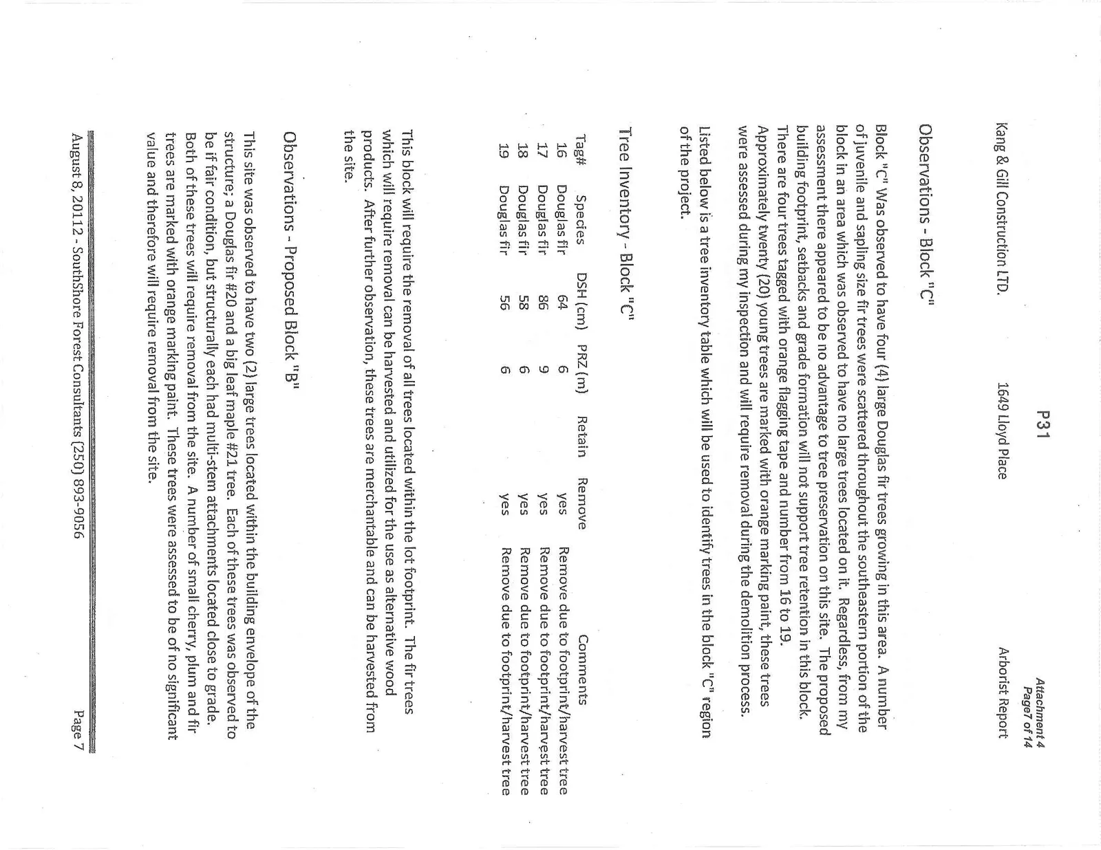
Observations - Block "C"
Block "C" Was observed to have four (4) large Douglas fir trees growing in this area. A number of juvenile and sapling size fir trees were scattered throughout the southeastern portion of the block in an area which was observed to have no large trees located on it. Regardless, from my assessment there appeared to be no advantage to tree preservation on this site. The proposed building footprint, setbacks and grade formation will not support tree retention in this block. There are four trees tagged with orange flagging tape and number from 16 to 19. Approximately twenty (20) young trees are marked with orange marking paint, these trees were assessed during my inspection and will require removal during the demolition process.
Listed below is a tree inventory table which will be used to identify trees in the block "C" region of the project.
Tree Inventory - Block "C"
| Tag# | Species | DSH (cm) | PRZ (m) | Retain | Remove | Comments |
|---|---|---|---|---|---|---|
| 16 | Douglas fir | 64 | 6 | yes | Remove due to footprint/harvest tree | |
| 17 | Douglas fir | 86 | 9 | yes | Remove due to footprint/harvest tree | |
| 18 | Douglas fir | 58 | 6 | yes | Remove due to footprint/harvest tree | |
| 19 | Douglas fir | 56 | 6 | yes | Remove due to footprint/harvest tree |
This block will require the removal of all trees located within the lot footprint. The fir trees which will require removal can be harvested and utilized for the use as alternative wood products. After further observation, these trees are merchantable and can be harvested from the site.
Observations - Proposed Block "B"
This site was observed to have two (2) large trees located within the building envelope of the structure; a Douglas fir #20 and a big leaf maple #21 tree. Each of these trees was observed to be if fair condition, but structurally each had multi-stem attachments located close to grade. Both of these trees will require removal from the site. A number of small cherry, plum and fir trees are marked with orange marking paint. These trees were assessed to be of no significant value and therefore will require removal from the site.
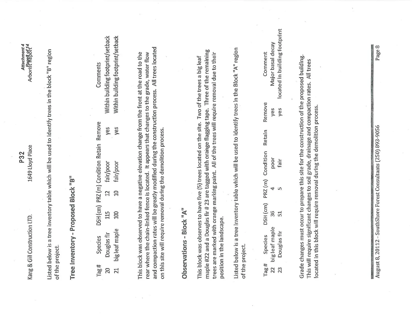
Listed below is a tree inventory table which will be used to identify trees in the block "B" region of the project.
Tree Inventory - Proposed Block "B"
| Tag # | Species | DSH (cm) | PRZ (m) | Condition | Retain | Remove | Comments |
|---|---|---|---|---|---|---|---|
| 20 | Douglas fir | 115 | 12 | fair/poor | yes | Within building footprint/setback | |
| 21 | big leaf maple | 100 | 10 | fair/poor | yes | Within building footprint/setback |
This block was observed to have a negative elevation change from the front at the road to the rear where the chain-linked fence is located. It appears that changes to the grade, water flow and compaction rates will be greatly modified during the construction process. All trees located on this site will require removal during the demolition process.
Observations - Block "A"
This block was observes to have five (5) trees located on the site. Two of the trees a big leaf maple #22 and a Douglas fir # 23 are tagged with orange flagging tape. Three of the remaining trees are marked with orange marking paint. All of the trees will require removal due to their position in the landscape.
Listed below is a tree inventory table which will be used to identify trees in the Block "A" region of the project.
Tree Inventory - Block "A"
| Tag # | Species | DSH (cm) | PRZ (m) | Condition | Retain | Remove | Comment |
|---|---|---|---|---|---|---|---|
| 22 | big leaf maple | 36 | 4 | poor | yes | Major basal decay | |
| 23 | Douglas fir | 51 | 5 | fair | yes | located in building footprint |
Grade changes must occur to prepare this site for the construction of the proposed building. This will require significant changes to soil grade, drainage and compaction rates. All trees located in this block will require removal during the demolition process.
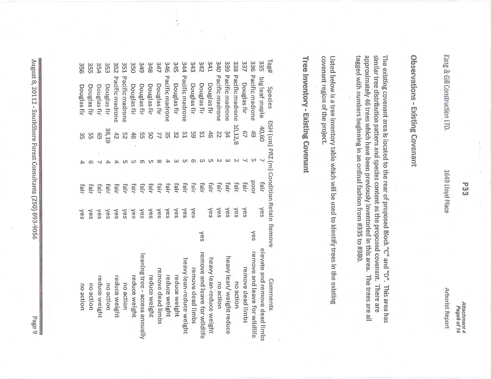
Observations - Existing Covenant
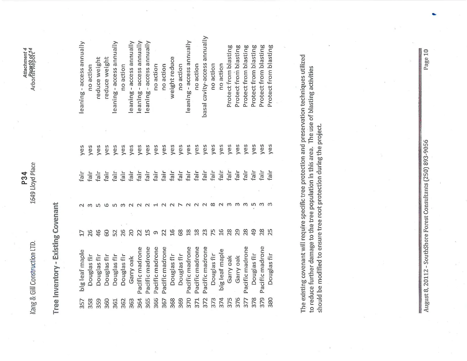
The existing covenant area is located to the rear of proposed Block "C" and "D". This area has similar tree distribution pattern and species content as the proposed covenant. There are approximately 46 trees which have been previously inventoried in this area. The trees are all tagged with numbers beginning in an ordinal fashion from #335 to #380.
Listed below is a tree inventory table which will be used to identify trees in the existing covenant region of the project.
Tree Inventory - Existing Covenant
| Tag# | Species | DSH (cm) | PRZ (m) | Condition | Retain | Remove | Comments |
|---|---|---|---|---|---|---|---|
| 335 | big leaf maple | 40,60 | 7 | fair | yes | elevate and remove dead limbs | |
| 336 | Pacific madrone | 49 | 5 | poor | yes | remove and leave for wildlife | |
| 337 | Douglas fir | 67 | 7 | fair | yes | remove dead limbs | |
| 338 | Pacific madrone | 10,12,8 | 2 | fair | yes | no action | |
| 339 | Pacific madrone | 34 | 3 | fair | yes | heavy lean/ weight reduce | |
| 340 | Pacific madrone | 22 | 2 | fair | yes | no action | |
| 341 | Douglas fir | 46 | 5 | fair | yes | heavy lean-reduce weight | |
| 342 | Douglas fir | 51 | 5 | fair | yes | remove and leave for wildlife | |
| 343 | Douglas fir | 59 | 6 | fair | yes | remove dead limbs | |
| 344 | Pacific madrone | 35 | 4 | fair | yes | heavy lean-reduce weight | |
| 345 | Douglas fir | 32 | 3 | fair | yes | reduce weight | |
| 346 | Pacific madrone | 35 | 4 | fair | yes | reduce weight | |
| 347 | Douglas fir | 77 | 8 | fair | yes | remove dead limbs | |
| 348 | Douglas fir | 50 | 5 | fair | yes | reduce weight | |
| 349 | Douglas fir | 55 | 6 | fair | yes | leaning tree - access annually | |
| 350 | Douglas fir | 46 | 5 | fair | yes | reduce weight | |
| 351 | Pacific madrone | 52 | 5 | fair | yes | no action | |
| 352 | Pacific madrone | 42 | 4 | fair | yes | reduce weight | |
| 353 | Douglas fir | 38,19 | 4 | fair | yes | no action | |
| 354 | Douglas fir | 69 | 7 | fair | yes | reduce weight | |
| 355 | Douglas fir | 55 | 6 | fair | yes | no action | |
| 356 | Douglas fir | 35 | 4 | fair | yes | no action | |
| 357 | big leaf maple | 17 | 2 | fair | yes | leaning - access annually | |
| 358 | Douglas fir | 26 | 3 | fair | yes | no action | |
| 359 | Douglas fir | 46 | 5 | fair | yes | reduce weight | |
| 360 | Douglas fir | 60 | 6 | fair | yes | reduce weight | |
| 361 | Douglas fir | 52 | 5 | fair | yes | leaning - access annually | |
| 362 | Douglas fir | 26 | 3 | fair | yes | no action | |
| 363 | Garry oak | 20 | 2 | fair | yes | leaning - access annually | |
| 364 | Pacific madrone | 22 | 2 | fair | yes | leaning - access annually | |
| 365 | Pacific madrone | 15 | 2 | fair | yes | leaning - access annually | |
| 366 | Pacific madrone | 9 | 1 | fair | yes | no action | |
| 367 | Pacific madrone | 22 | 2 | fair | yes | no action | |
| 368 | Douglas fir | 16 | 2 | fair | yes | weight reduce | |
| 369 | Douglas fir | 68 | 7 | fair | yes | no action | |
| 370 | Pacific madrone | 18 | 2 | fair | yes | leaning - access annually | |
| 371 | Pacific madrone | 18 | 2 | fair | yes | no action | |
| 372 | Pacific madrone | 23 | 2 | fair | yes | basal cavity-access annually | |
| 373 | Douglas fir | 75 | 8 | fair | yes | no action | |
| 374 | big leaf maple | 16 | 2 | fair | yes | no action | |
| 375 | Garry oak | 28 | 3 | fair | yes | Protect from blasting | |
| 376 | Garry oak | 29 | 3 | fair | yes | Protect from blasting | |
| 377 | Pacific madrone | 28 | 3 | fair | yes | Protect from blasting | |
| 378 | Douglas fir | 49 | 5 | fair | yes | Protect from blasting | |
| 379 | Pacific madrone | 28 | 3 | fair | yes | Protect from blasting | |
| 380 | Douglas fir | 25 | 3 | fair | yes | Protect from blasting |
The existing covenant will require specific tree protection and preservation techniques utilized to reduce further damage to the tree population in this area. The use of blasting activities should be modified to ensure tree root protection during the project.
Recommendations
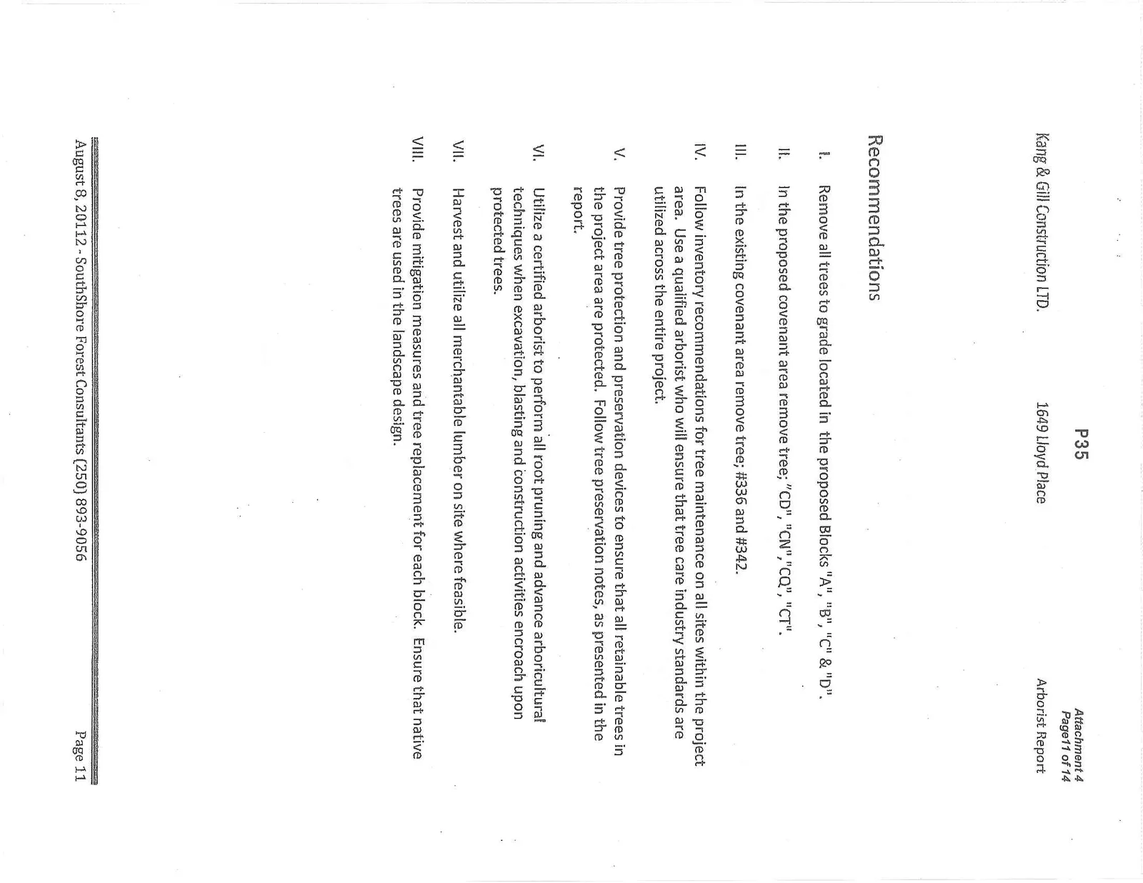
I. Remove all trees to grade located in the proposed Blocks "A", "B", "C" & "D". II. In the proposed covenant area remove tree; "CD", "CN","CQ", "CT". III. In the existing covenant area remove tree; #336 and #342. IV. Follow inventory recommendations for tree maintenance on all sites within the project area. Use a qualified arborist who will ensure that tree care industry standards are utilized across the entire project. V. Provide tree protection and preservation devices to ensure that all retainable trees in the project area are protected. Follow tree preservation notes, as presented in the report. VI. Utilize a certified arborist to perform all root pruning and advance arboricultural techniques when excavation, blasting and construction activities encroach upon protected trees. VII. Harvest and utilize all merchantable lumber on site where feasible. VIII. Provide mitigation measures and tree replacement for each block. Ensure that native trees are used in the landscape design.
Conclusion
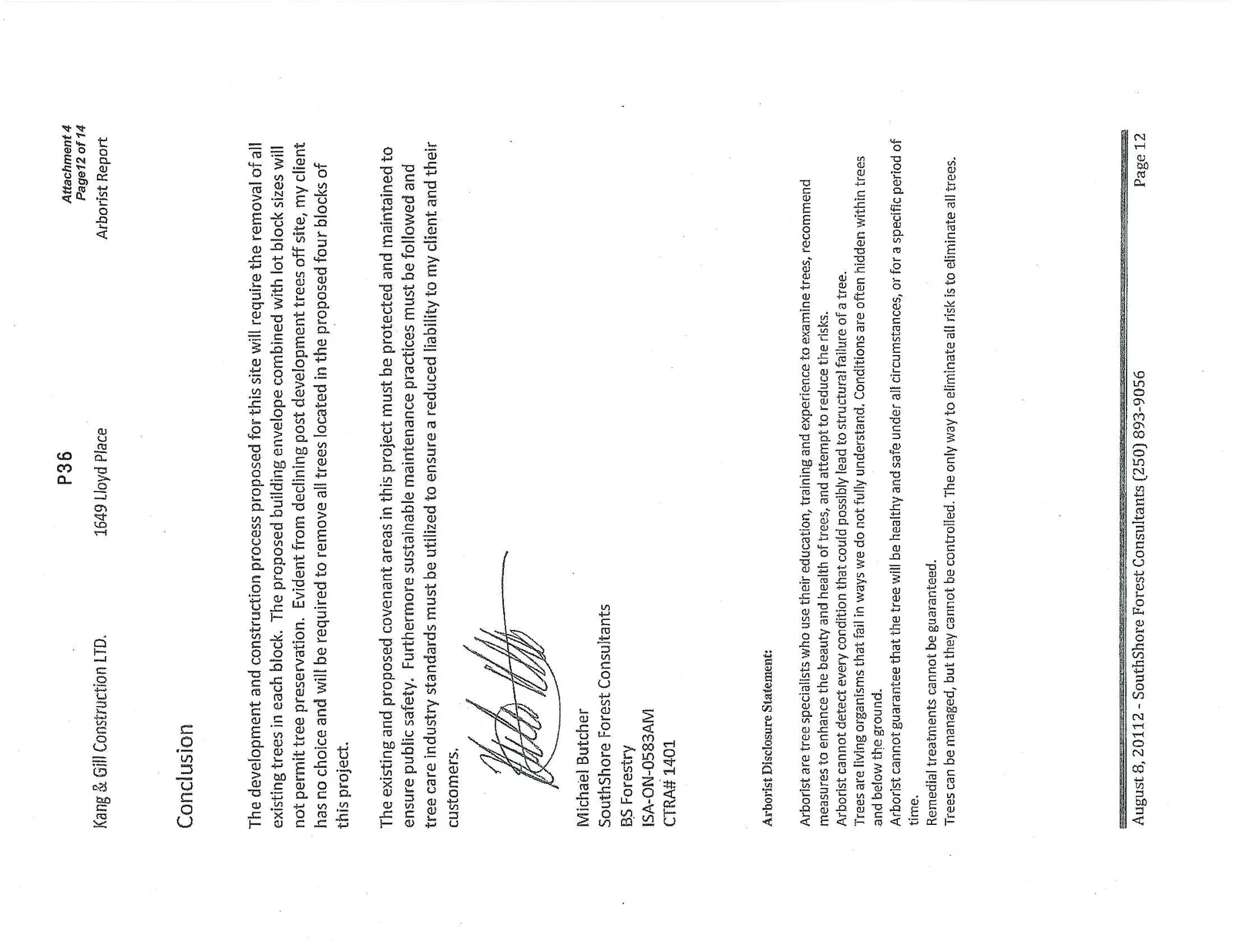
The development and construction process proposed for this site will require the removal of all existing trees in each block. The proposed building envelope combined with lot block sizes will not permit tree preservation. Evident from declining post development trees off site, my client has no choice and will be required to remove all trees located in the proposed four blocks of this project.
The existing and proposed covenant areas in this project must be protected and maintained to ensure public safety. Furthermore sustainable maintenance practices must be followed and tree care industry standards must be utilized to ensure a reduced liability to my client and their customers.
Michael Butcher SouthShore Forest Consultants BS Forestry ISA-ON-0583AM CTRA# 1401
Arborist Disclosure Statement:
Arborist are tree specialists who use their education, training and experience to examine trees, recommend measures to enhance the beauty and health of trees, and attempt to reduce the risks. Arborist cannot detect every condition that could possibly lead to structural failure of a tree. Trees are living organisms that fail in ways we do not fully understand. Conditions are often hidden within trees and below the ground. Arborist cannot guarantee that the tree will be healthy and safe under all circumstances, or for a specific period of time. Remedial treatments cannot be guaranteed. Trees can be managed, but they cannot be controlled. The only way to eliminate all risk is to eliminate all trees.
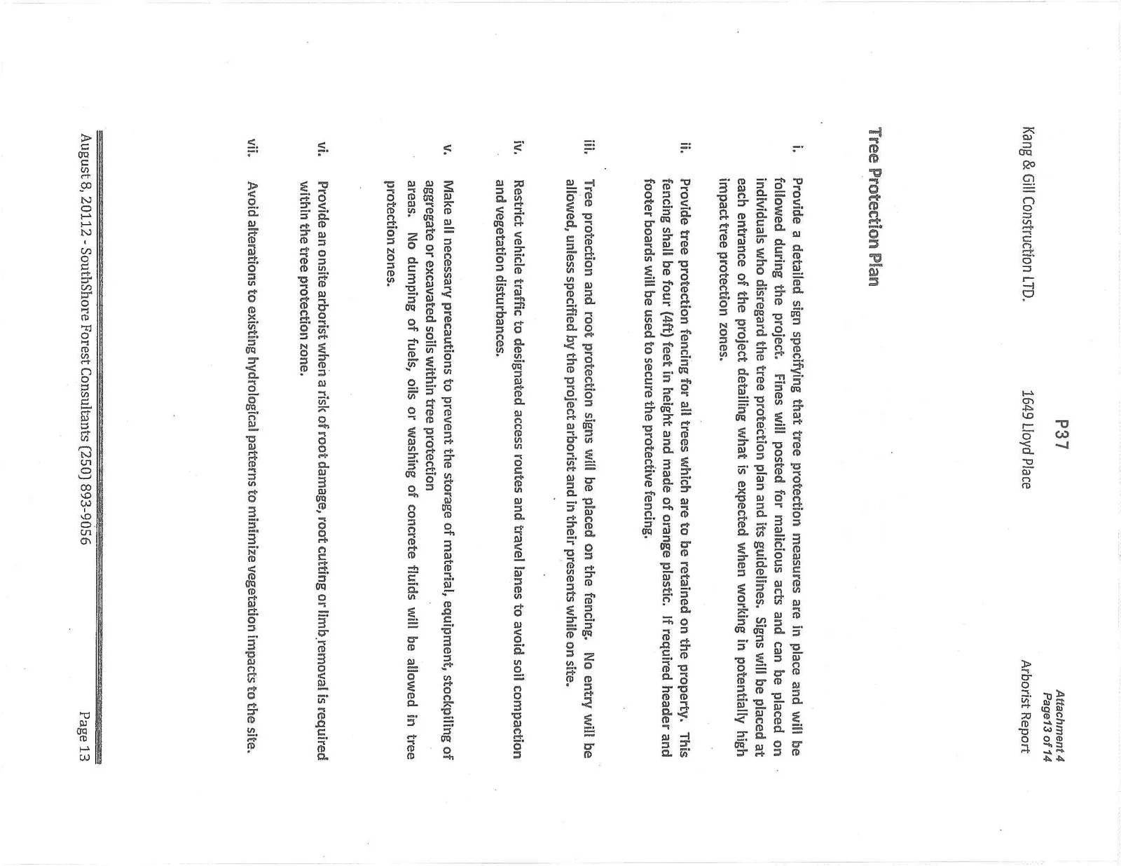
Tree Protection Plan
i. Provide a detailed sign specifying that tree protection measures are in place and will be followed during the project. Fines will posted for malicious acts and can be placed on individuals who disregard the tree protection plan and its guidelines. Signs will be placed at each entrance of the project detailing what is expected when working in potentially high impact tree protection zones. ii. Provide tree protection fencing for all trees which are to be retained on the property. This fencing shall be four (4ft) feet in height and made of orange plastic. If required header and footer boards will be used to secure the protective fencing. iii. Tree protection and root protection signs will be placed on the fencing. No entry will be allowed, unless specified by the project arborist and in their presents while on site. iv. Restrict vehicle traffic to designated access routes and travel lanes to avoid soil compaction and vegetation disturbances. v. Make all necessary precautions to prevent the storage of material, equipment, stockpiling of aggregate or excavated soils within tree protection areas. No dumping of fuels, oils or washing of concrete fluids will be allowed in tree protection zones. vi. Provide an onsite arborist when a risk of root damage, root cutting or limb removal is required within the tree protection zone. vii. Avoid alterations to existing hydrological patterns to minimize vegetation impacts to the site. viii. The use of a project arborist is required to provide layout of tree protection zones. The project arborist(s) will provide pre-construction information to all parties involved with the project. The arborist must be notified 24hrs prior to construction activities in sensitive areas. The project arborist should be used to provide root and branch pruning when diameters are greater than 6cm. ix. At no time will tree protection zones be removed from the project unless approved by the project arborist.
Document Images
(14)