Council Meeting/Documents/Sketch Plan Showing Proposed Park Dedication, Road Dedication and Consolidation
Appendix
Sketch Plan Showing Proposed Park Dedication, Road Dedication and Consolidation
October 1, 2013Page 291 section
Survey sketch plan illustrating the proposed land subdivision and park dedication near Millstream Creek.
Amended 15 May 2013
Sketch Plan Showing Proposed Park Dedication, Road Dedication and Consolidation of
- Lot A (DD ES 48097), Plan 39031, Except Part in Plan EPP14788 (Unregistered);
- Pt of Section 104 Shown as Closed Road on Plan EPP14786; Except Part in Plan EPP14787 (Unregistered);
- Lot 1, Plan 5531; Except Parts in Plan 649R/W and Plan EPP14787 (Unregistered); All in Sections 98 and 104 Esquimalt District.
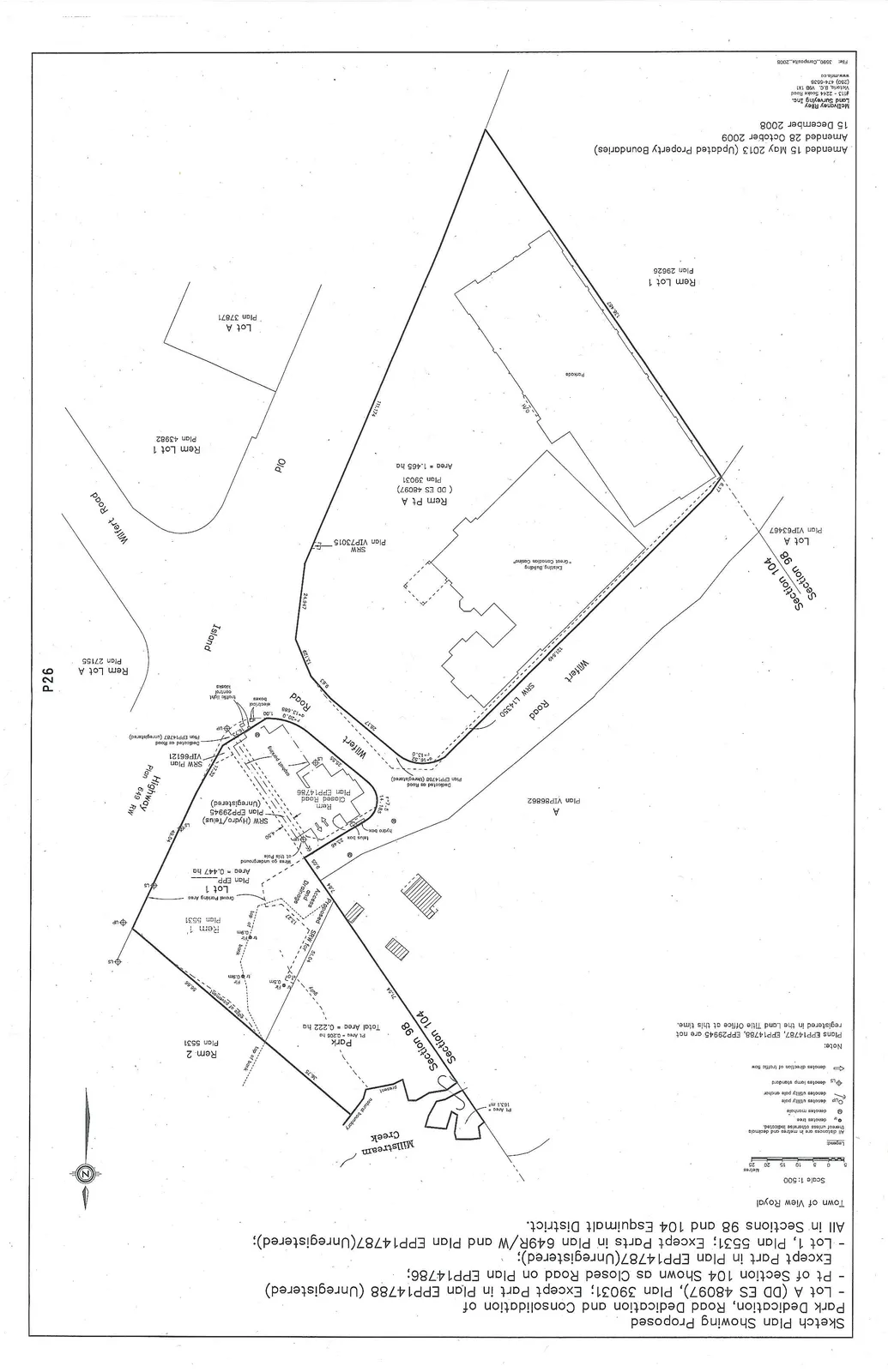
Town of View Royal
Scale 1:500 (Scale bar from 0 to 25 metres)
Legend
- (Solid circle) denotes iron pin found
- (Open circle with dot) denotes standard iron post found
- (Circle with 'M') denotes manhole
- (Circle with 'CB') denotes catch basin
- (Solid square) denotes utility pole
- (Open square) denotes utility pole and/or luminaire standard
- (Square with 'LS') denotes lamp standard
- (Arrow) denotes direction of traffic flow
- All distances are in metres and decimals thereof unless otherwise indicated.
Note:
Plans EPP14787, EPP14788, EPP29945 are not registered in the Land Title Office at this time.
Plan Details
- Millstream Creek (Natural Boundary)
- Park
- Pt Area = 0.056 ha
- Total Area = 0.222 ha
- Lot 1 Plan EPP —
- Area = 0.447 ha
- Gravel Parking Area
- Rem. 1 Plan 5531
- Rem. 2 Plan 5531
- Rem Pt A (DD ES 48097) Plan 39031
- Area = 1.465 ha
- Existing Building "Great Canadian Casino"
- Rem. Closed Road Plan EPP14786
- Rem Lot 1 Plan 43982
- Lot A Plan 37871
- Rem Lot 1 Plan 29625 (Parkside)
- Lot A Plan VIP63467
- Rem Lot A Plan 27155
- Section 104
- Section 98
- Wilfert Road
- Highway Plan 649 RW
- SRW L14350
- SRW Plan VIP73015
- SRW (Hydro/Telus) Plan EPP29945 (Unregistered)
- SRW Plan VIP66121
- Proposed SRW for Access and Drainage
- Island
- PID
Amended 15 May 2013 (Updated Property Boundaries) Amended 28 October 2009 15 December 2008
McElhanney Riley Land Surveying Inc. #121 - 2244 Sooke Road Victoria, B.C. V9B 1X1 Ph (250) 474-5500 www.mri-ls.ca
File: 3590_Composite_2008
Page 29
Extracted from: 2013 10 01 Council Agenda