Staff Report Appendices (Attachments 1-5)
Technical attachments and supporting documentation for the 10 Erskine Lane rezoning staff report.
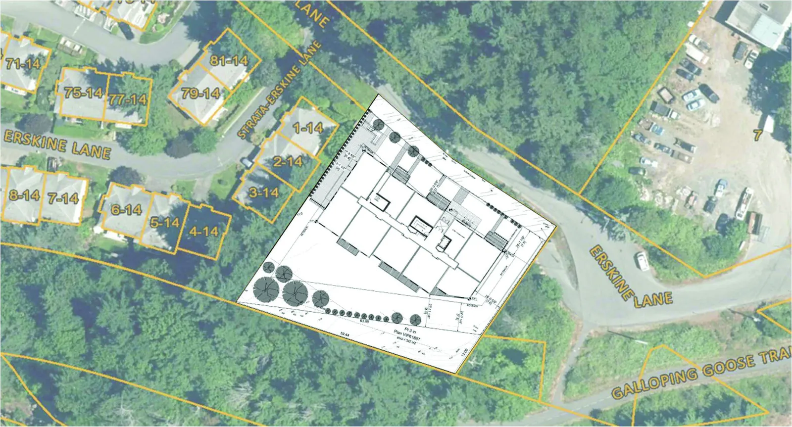
4.2 TRIP GENERATION
The number of site trips expected to be generated from the proposed development were calculated using the Institute of Transportation Engineers’ (ITE) Trip Generation Manual (11th Edition). The Trip Generation Manual provides trip rates for a wide variety of land uses gathered from actual sites across North America over the past 40 years.
The results of the trip generation are summarized in Table 2. The development is expected to generate 16 trips (4 inbound / 12 outbound) during the AM peak hour and 17 trips (10 inbound / 7 outbound) during the PM peak hour.
TABLE 2: TRIP GENERATION SUMMARY – AM AND PM PEAK HOUR
| ITE Code | Land Use | Units | Trip Rate | Trips In | Trips Out | Total Trips |
|---|---|---|---|---|---|---|
| AM Peak Hour | ||||||
| 221 | Multifamily Housing (Mid-Rise) | 43 Units | 0.37 / unit | 4 | 12 | 16 |
| Total (AM Peak): | 4 | 12 | 16 | |||
| PM Peak Hour | ||||||
| 221 | Multifamily Housing (Mid-Rise) | 43 Units | 0.39 / unit | 10 | 7 | 17 |
| Total (PM Peak): | 10 | 7 | 17 |
4.3 TRIP ASSIGNMENT
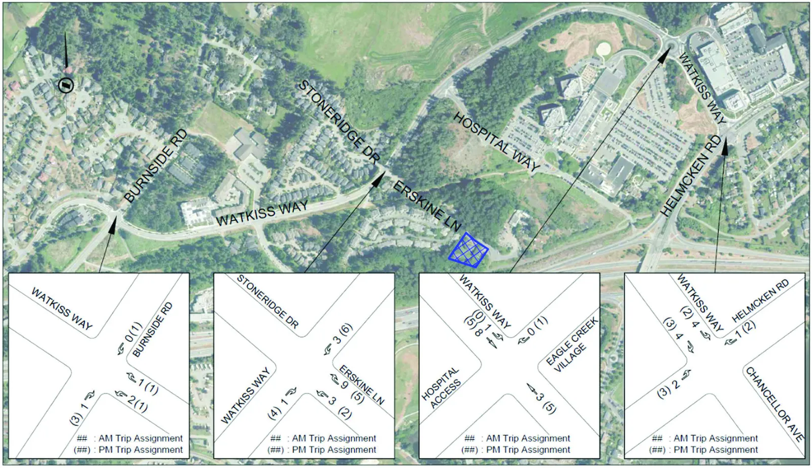
The trip assignment for the primary trips were based on the existing traffic patterns and the key origins and destinations for traffic in the area. The trips generated by the development during the AM and PM peak hours were assigned based on the following distribution ratios:
Inbound Trips (AM and PM):
- 15% of inbound trips come from Helmcken Road (North);
- 35% of inbound trips come from Helmcken Road (South);
- 10% of inbound trips come from Burnside Road (North);
- 35% of inbound trips come from Burnside Road (South); and
- 5% of inbound trip come from Eagle Creek Village.
Outbound Trips (AM and PM):
- 30% of outbound trips are heading to Helmcken Road (North);
- 35% of outbound trips are heading to Helmcken Road (South);
- 10% of outbound trips are heading to Burnside Road (North);
- 20% of outbound trips are heading to Burnside Road (South); and
- 5% of outbound trips are heading to Eagle Creek Village.
The resulting trip assignment is shown in Figure 6.
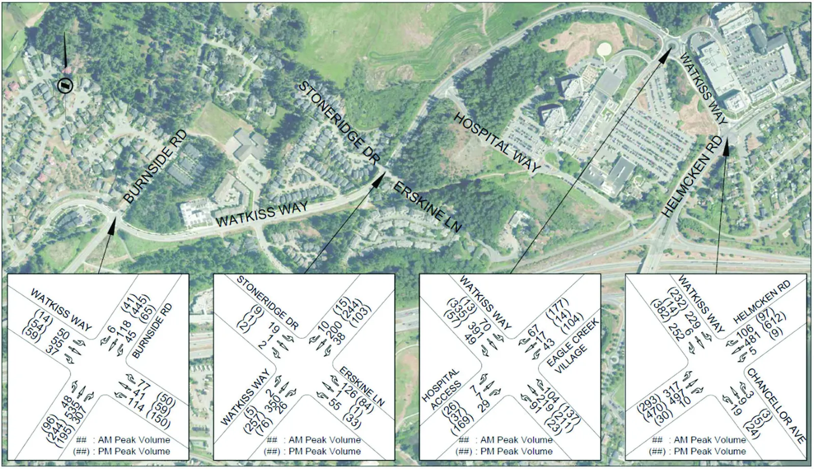
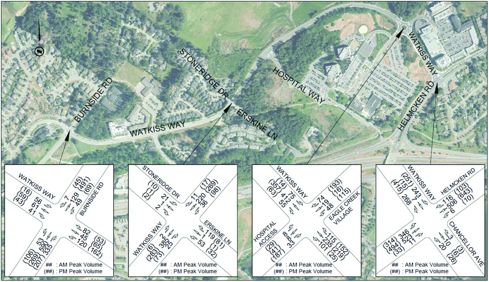
The 2023 post development volumes were obtained by adding the trips generated by the site to the 2023 background volumes. The resulting 2023 post development volumes are shown in Figure 7.
4.4 OPENING DAY CONDITIONS
The opening day (2023) background and post development volumes were analyzed in Synchro / SimTraffic / SIDRA software to determine the opening day conditions during the AM and PM peak hours. The post development conditions were compared to the background conditions during each peak hour to determine the impact of the development on the study area road network. The modelling included the new Watkiss Way / Erskine Lane single-lane roundabout that is expected to be constructed by 2023.
4.4.1 AM PEAK HOUR
The 2023 background and post development AM peak hour analysis results are summarized in Table 3.
TABLE 3: OPENING DAY (2023) TRAFFIC CONDITIONS – AM PEAK HOUR
| Intersection (EW / NS) | Movement | 2023 Background Conditions – AM Peak | 2023 Post Development Conditions – AM Peak | ||||
|---|---|---|---|---|---|---|---|
| LOS | Delay (s) | 95th % Queue (m) | LOS | Delay (s) | 95th % Queue (m) | ||
| Watkiss Way / Burnside Road | EB L/T/R | B | 19.5 | 31.9 | B | 19.4 | 33.5 |
| WB L/T/R | D | 49.2 | 43.9 | D | 51.0 | 46.5 | |
| NB L/T | B | 13.4 | 58.2 | B | 13.5 | 58.4 | |
| NBR | A | 2.0 | 24.3 | A | 2.0 | 28.3 | |
| SB L/T/R | A | 7.7 | 31.9 | A | 7.7 | 34.6 | |
| Watkiss Way / Erskine Lane / Stoneridge Drive | EB L/T/R | A | 6.1 | 15.9 | A | 6.2 | 13.7 |
| WB L/T/R | A | 5.2 | 12.0 | A | 5.2 | 10.4 | |
| NB L/T/R | A | 7.0 | 16.4 | A | 7.3 | 15.2 | |
| SB L/T/R | A | 4.2 | 5.8 | A | 4.3 | 5.2 | |
| Watkiss Way / Hospital Access / Eagle Creek Village Access | EB L/T/R | B | 15.2 | 34.0 | B | 15.6 | 37.1 |
| WB L/T | A | 8.0 | 33.4 | A | 8.1 | 32.0 | |
| WBR | A | 0.0 | 29.2 | A | 0.0 | 1.8 | |
| NB L/T/R | A | 8.2 | 12.5 | A | 8.3 | 13.5 | |
| SB L/T/R | A | 8.0 | 11.9 | A | 8.0 | 11.7 | |
| Watkiss Way / Chancellor Ave / Helmcken Road | EB L/T | D | 42.5 | 65.0 | D | 42.8 | 62.8 |
| EBR | A | 4.8 | 51.6 | A | 4.8 | 46.9 | |
| WBL | C | 23.4 | 6.2 | C | 23.4 | 6.1 | |
| WB T/R | B | 14.8 | 1.7 | B | 14.8 | 1.3 | |
| NBL | F | 116.2 | 62.6 | F | 120.0 | 52.6 | |
| NB T/R | B | 15.4 | 38.0 | B | 15.6 | 59.4 | |
| SBL | D | 50.2 | 10.6 | D | 50.4 | 8.9 | |
| SBT | C | 34.5 | 113.3 | C | 35.0 | 102.1 | |
| SBR | A | 4.6 | 25.5 | A | 4.7 | 26.2 |
Under 2023 AM peak hour background volumes, the Watkiss Way / Burnside Road intersection operates adequately, with the westbound movement at LOS D while the remaining movements are at LOS A/B. The Watkiss Way / Erskine Lane and Watkiss Way / Hospital Access roundabouts operate well (all movements at LOS A/B) in the AM peak hour under background conditions.
At the Watkiss Way / Helmcken Road intersection, the northbound left turn is failing (LOS F) under background conditions. The remaining movements are at LOS D or better during the AM peak. Signal timing adjustments to the intersection in Synchro resulted in all movements operating at LOS D or better and should be considered to improve the operations of the Watkiss Way / Helmcken Road intersection.
Under post development volumes, the addition of site traffic does not impact the operations of the study intersections in the AM peak hour. No changes to the levels of service occur at any of the intersections as a result of development traffic. All 95th percentile turn lane queues at Watkiss Way / Helmcken Road are less than the provided storage.
4.4.2 PM PEAK HOUR
The 2023 background and post development PM peak hour analysis results are summarized in Table 4.
TABLE 4: OPENING DAY (2023) TRAFFIC CONDITIONS – PM PEAK HOUR
| Intersection (EW / NS) | Movement | 2023 Background Conditions – PM Peak | 2023 Post Development Conditions – PM Peak | ||||
|---|---|---|---|---|---|---|---|
| LOS | Delay (s) | 95th % Queue (m) | LOS | Delay (s) | 95th % Queue (m) | ||
| Watkiss Way / Burnside Road | EB L/T/R | B | 11.5 | 25.5 | B | 11.5 | 25.1 |
| WB L/T/R | D | 35.5 | 50.8 | D | 35.9 | 54.0 | |
| NB L/T | B | 10.8 | 55.8 | B | 10.8 | 52.1 | |
| NBR | A | 1.8 | 20.1 | A | 1.8 | 21.6 | |
| SB L/T/R | B | 14.5 | 78.9 | B | 14.7 | 70.1 | |
| Watkiss Way / Erskine Lane / Stoneridge Drive | EB L/T/R | A | 6.5 | 18.1 | A | 6.7 | 18.7 |
| WB L/T/R | A | 6.1 | 13.7 | A | 6.2 | 15.7 | |
| NB L/T/R | A | 5.0 | 11.2 | A | 5.1 | 13.3 | |
| SB L/T/R | A | 4.5 | 5.6 | A | 4.5 | 4.6 | |
| Watkiss Way / Hospital Access / Eagle Creek Village Access | EB L/T/R | B | 11.0 | 25.6 | B | 11.1 | 31.5 |
| WB L/T | A | 7.9 | 28.9 | A | 8.0 | 30.4 | |
| WBR | A | 0.9 | 3.8 | A | 0.8 | 3.4 | |
| NB L/T/R | B | 17.1 | 20.7 | B | 17.3 | 23.1 | |
| SB L/T/R | B | 12.1 | 19.0 | B | 12.3 | 21.0 | |
| Watkiss Way / Chancellor Ave / Helmcken Road | EB L/T | E | 69.2 | 114.5 | E | 69.4 | 146.2 |
| EBR | C | 20.8 | 85.4 | C | 21.1 | 85.5 | |
| WBL | D | 47.7 | 10.3 | D | 47.8 | 11.2 | |
| WB T/R | C | 29.0 | 1.8 | C | 29.0 | 2.1 | |
| NBL | F | 95.2 | 82.3 | F | 96.8 | 73.6 | |
| NB T/R | B | 12.0 | 84.9 | B | 12.0 | 60.5 | |
| SBL | E | 77.3 | 13.4 | E | 77.3 | 12.0 | |
| SBT | C | 26.5 | 172.7 | C | 26.6 | 181.8 | |
| SBR | A | 3.0 | 24.1 | A | 3.2 | 23.4 |
Under 2023 PM peak hour background volumes, the Watkiss Way / Burnside Road intersection operates adequately with the westbound movement operating at LOS D while the remaining movements are at LOS A/B. The roundabouts at Watkiss Way / Erskine Lane and Watkiss Way / Hospital Access operate well (LOS A/B for all movements) under PM background conditions.
At the Watkiss Way / Helmcken Road intersection, under background conditions, there are multiple movements at LOS E/F in the PM peak hour, including the eastbound left / through movement and the northbound and southbound left turn movements. Signal timing adjustments to the intersection in Synchro resulted in all movements operating at LOS D or better and could be considered to improve the operations of the Watkiss Way / Helmcken Road intersection. The eastbound left/through and eastbound right turn queues extend beyond the right turn lane with and without the development traffic. Both the eastbound left/through and right turn movements are impacting the adjacent lane movements traffic. The northbound and southbound left turn queue lengths are less than the provided storage with and without the development.
Under post-development conditions, the addition of site traffic does not impact the operations or queue lengths at the study intersections during the PM peak hour, and the levels of service are unchanged with the addition of site traffic compared to background conditions.
5.0 10-YEAR POST DEVELOPMENT HORIZON (2033)
In order to determine the long-term impact of the proposed development, the long-term background and post development conditions were examined for the 10-year post development horizon (2033).
5.1 BACKGROUND VOLUMES (2033)
The long-term 2033 background volumes were determined by applying the annual growth rates of 0.5% to Helmcken Road and 1% to all other roads to the 2023 background volumes plus the concurrent developments. The resulting 2033 background volumes are shown in Figure 8.
5.2 POST DEVELOPMENT VOLUMES (2033)
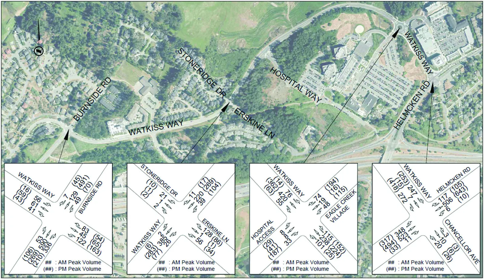
The 2033 post development volumes were obtained by adding the trips generated by the site to the 2033 background volumes. The resulting 2033 post development volumes are shown in Figure 9.
5.3 LONG TERM CONDITIONS
The long-term (2033) background and post development volumes were analyzed in Synchro / SimTraffic / SIDRA software to determine the long-term conditions during the AM and PM peak hours. The post development conditions were compared to the background conditions during each peak hour to determine the long-term impact of the development on the study area road network.
5.3.1 AM PEAK HOUR
The 2033 background and post development AM peak hour analysis results are summarized in Table 5.
TABLE 5: LONG-TERM (2033) TRAFFIC CONDITIONS – AM PEAK HOUR
| Intersection (EW / NS) | Movement | 2033 Background Conditions – AM Peak | 2033 Post Development Conditions – AM Peak | ||||
|---|---|---|---|---|---|---|---|
| LOS | Delay (s) | 95th % Queue (m) | LOS | Delay (s) | 95th % Queue (m) | ||
| Watkiss Way / Burnside Road | EB L/T/R | C | 20.7 | 35.3 | C | 20.7 | 38.1 |
| WB L/T/R | E | 61.8 | 46.9 | E | 64.8 | 47.2 | |
| NB L/T | B | 16.2 | 61.8 | B | 16.2 | 66.7 | |
| NBR | A | 2.1 | 27.9 | A | 2.1 | 30.2 | |
| SB L/T/R | A | 8.6 | 38.3 | A | 8.6 | 39.0 | |
| Watkiss Way / Erskine Lane / Stoneridge Drive | EB L/T/R | A | 6.5 | 16.5 | A | 6.6 | 20.0 |
| WB L/T/R | A | 5.4 | 13.6 | A | 5.5 | 13.7 | |
| NB L/T/R | A | 7.5 | 17.0 | A | 7.8 | 18.0 | |
| SB L/T/R | A | 4.4 | 7.7 | A | 4.5 | 7.2 | |
| Watkiss Way / Hospital Access / Eagle Creek Village Access | EB L/T/R | B | 18.7 | 36.7 | B | 19.4 | 37.3 |
| WB L/T | A | 8.7 | 33.0 | A | 8.8 | 33.1 | |
| WBR | A | 0.0 | 4.0 | A | 0.0 | 40.2 | |
| NB L/T/R | A | 8.9 | 11.8 | A | 9.0 | 14.7 | |
| SB L/T/R | A | 8.9 | 12.1 | A | 8.9 | 13.4 | |
| Watkiss Way / Chancellor Ave / Helmcken Road | EB L/T | D | 45.3 | 66.8 | D | 46.0 | 73.2 |
| EBR | A | 6.3 | 55.9 | A | 6.5 | 62.0 | |
| WBL | C | 23.9 | 7.0 | C | 24.0 | 7.3 | |
| WB T/R | B | 15.4 | 2.3 | B | 15.4 | 0.7 | |
| NBL | F | 166.8 | 86.3 | F | 171.2 | 83.7 | |
| NB T/R | B | 18.1 | 81.9 | B | 18.2 | 87.0 | |
| SBL | D | 51.8 | 8.9 | D | 52.0 | 9.5 | |
| SBT | D | 38.2 | 140.0 | D | 38.5 | 179.4 | |
| SBR | A | 5.7 | 25.1 | A | 5.8 | 25.6 |
Under 2033 background conditions, the westbound movement at the Watkiss Way / Burnside Road intersection operates at LOS E during the AM peak hour with the existing signal timing. The remaining movements are at LOS C or better. The operations of the intersections can be improved to acceptable levels (LOS D or better for all movements) by optimizing the signal timing. The Watkiss Way / Erskine Lane and Watkiss Way / Hospital Access roundabouts operate well, with all movements at LOS A/B under AM peak hour background conditions.
At the Watkiss Way / Helmcken Road intersection, the northbound left turn will operate at a LOS F under 2033 background conditions and the 95th percentile queues do not exceed the storage. Multiple other movements are at LOS D, including the southbound left, southbound through, and eastbound left / through movements. Signal timing adjustments to the intersection in Synchro resulted in all movements operating at LOS D or better and could be considered to improve the operations of the Watkiss Way / Helmcken Road intersection.
Under 2033 post development conditions, the addition of development traffic does not impact the operations or queues at the study intersections during the AM peak hour. The levels of service of all movements are unchanged from 2033 background conditions.
5.3.2 PM PEAK HOUR
The 2033 background and post development PM peak hour analysis results are summarized in Table 6.
TABLE 6: LONG-TERM (2033) TRAFFIC CONDITIONS – PM PEAK HOUR
| Intersection (EW / NS) | Movement | 2033 Background Conditions – PM Peak | 2033 Post Development Conditions – PM Peak | ||||
|---|---|---|---|---|---|---|---|
| LOS | Delay (s) | 95th % Queue (m) | LOS | Delay (s) | 95th % Queue (m) | ||
| Watkiss Way / Burnside Road | EB L/T/R | B | 11.6 | 28.4 | B | 11.5 | 29.7 |
| WB L/T/R | D | 41.1 | 60.6 | D | 41.4 | 71.7 | |
| NB L/T | B | 12.7 | 80.6 | B | 12.8 | 86.4 | |
| NBR | A | 1.8 | 20.6 | A | 1.8 | 23.4 | |
| SB L/T/R | B | 19.1 | 91.2 | B | 19.2 | 91.1 | |
| Watkiss Way / Erskine Lane / Stoneridge Drive | EB L/T/R | A | 6.9 | 17.3 | A | 7.1 | 18.8 |
| WB L/T/R | A | 6.4 | 14.9 | A | 6.6 | 19.2 | |
| NB L/T/R | A | 5.2 | 12.8 | A | 5.3 | 13.2 | |
| SB L/T/R | A | 4.7 | 5.7 | A | 4.7 | 5.0 | |
| Watkiss Way / Hospital Access / Eagle Creek Village Access | EB L/T/R | B | 12.6 | 28.1 | B | 12.7 | 27.7 |
| WB L/T | A | 8.5 | 31.8 | A | 8.6 | 30.5 | |
| WBR | A | 1.0 | 2.4 | A | 1.0 | 5.5 | |
| NB L/T/R | C | 22.7 | 21.6 | C | 23.0 | 23.4 | |
| SB L/T/R | B | 14.2 | 22.0 | B | 14.5 | 22.7 | |
| Watkiss Way / Chancellor Ave / Helmcken Road | EB L/T | E | 71.5 | 157.1 | E | 71.7 | 168.8 |
| EBR | C | 27.8 | 86.9 | C | 28.1 | 85.7 | |
| WBL | D | 48.7 | 14.1 | D | 48.8 | 12.9 | |
| WB T/R | C | 30.0 | 0.7 | C | 30.0 | 2.2 | |
| NBL | F | 114.5 | 97.5 | F | 116.9 | 106.8 | |
| NB T/R | B | 13.7 | 104.3 | B | 13.7 | 118.4 | |
| SBL | E | 79.0 | 11.0 | E | 79.0 | 11.5 | |
| SBT | C | 28.6 | 186.4 | C | 28.7 | 202.9 | |
| SBR | A | 3.7 | 22.8 | A | 3.9 | 24.5 |
Under 2033 background volumes, the Watkiss Way / Burnside Road intersection operates adequately during the PM peak hour, with all movements at LOS D or better and most at LOS A/B. The roundabouts at Watkiss Way / Erskine Lane and Watkiss Way / Hospital Access operate well under background volumes, with all movements at LOS C or better during the PM peak hour.
At the Watkiss Way / Helmcken Road intersection, there are multiple failing movements during the PM peak hour, with the northbound left turn at LOS F and the southbound left and eastbound left / through movements at LOS E under background conditions. Signal timing adjustments to the intersection in Synchro resulted in all movements operating at LOS D or better and should be considered to improve the operations of the Watkiss Way / Helmcken Road intersection. The northbound left turn 95th percentile queue lengths will be within 10m of the back of the storage available in the dual lanes without the development. The eastbound 95th percentile queues will not extend back to the Watkiss / Hospital / Eagle Creek roundabout however, the eastbound left / through and eastbound right turn queues will block each other and extend the queues in the single lane section with and without the development.
Under 2033 post development conditions, the addition of the development traffic does not impact the operations of the study intersections during the PM peak hour. The LOS of all movements are unchanged from 2033 background conditions. In the 2033 post-development scenario the northbound left turn exceeds the provided dual lane storage by 10m (less than 2 vehicle lengths). This can be handled by the additional storage length provided for the outside left turn lane which has an additional 10m of parallel storage (105m) compared to the inside left turn lane (95m). Adjustments to signal timing, in the long term, may also improve this queue length.
6.0 ACCESS REVIEW
6.1 SPACING
The proposed site access is located on Erskine Lane 270m south of Watkiss Way, which exceeds the TAC recommended minimum corner clearance of 15m for local roads from a stop-controlled major intersection. The spacing between the access and the driveway for the adjacent property is 70m, which exceeds the 5m spacing recommended by TAC. Based on the above, the access spacing for the proposed development is appropriate.
6.2 SIGHTLINES
The TAC Geometric Design Guide for Canadian Roads (2017) provides recommended minimum intersection sight distances for drivers turning out onto a road from a stop-controlled intersection. For turning onto a road with a speed limit of 30km/h, TAC recommends a sight distance of 65m looking to the right and 55m looking to the left (Tables 9.9.4 / 9.9.6).
The development access is located at the south end of Erskine Lane. For exiting drivers looking left (to the north), the sightline is 120m, which exceeds the TAC recommendation. For drivers looking to the right (south), the sight line extends to the end of Erskine Lane, a distance of 45m. Although this is 20m less than the TAC recommendation, the only traffic on Erskine south of the proposed access is to the 5 Erskine Lane and 7 Erskine Lane developments which both have accesses at the end of Erskine Lane. Drivers exiting the 10 Erskine Lane development will be able to see traffic exiting the 5 Erskine Lane and 7 Erskine Lane developments and therefore will be able to adequately determine when it is safe to turn out of the development. As a result, the sightlines for the 10 Erskine Lane access are adequate.
7.0 ACTIVE TRANSPORTATION
7.1 PEDESTRIANS AND CYCLISTS
Currently, Erskine Lane does not have any pedestrian or cycling infrastructure, however since Erskine Lane is a dead-end roadway less than 300m in length with low volumes and speeds, pedestrians and cyclists may travel on Erskine Lane without requiring dedicated infrastructure. However, with the development of 5, 7, and 9 Erskine Lane upgrades to the pedestrian / bicycle facilities on Erskine Lane are planned as per the Town of View Royal VRSD-R10 cross section.
There are painted bike lanes on both sides of Watkiss Way and Helmcken Road within the study area, as well as on Burnside Road north of Watkiss Way. Watkiss Way has a sidewalk along the north side of the road that runs from Burnside Road to the transit stop east of Erskine Lane. With 9 Erskine Lane development there will be sidewalk provided along their Watkiss Way frontage.
The development site is adjacent to the Galloping Goose multi-use pathway, which offers a connection to the Victoria General Hospital and the Eagle Creek Village commercial area as well as to downtown Victoria and Langford (via the E&N Rail Trail). A paved connection to the Goose is located 30m from the access. There is also an informal gravel pathway on CRD utility right-of-way (informally referred to as the ‘Hospital Trail’) located 140m north of the site off Erskine Lane. This pathway is usable by pedestrians but is not fully accessible. The Hospital Trail provides a connection to the Victoria General Hospital to the east and to the transit stop at the Watkiss Way / Talcott Road intersection to the west.
7.2 TRANSIT
The nearest transit stops are located 290m northwest of the site on Watkiss Way, just east of Erskine Lane. These stops are serviced by BC Transit Routes #22 (Vic General / Hillside Centre), #39 (Westhills / Interurban / Royal Oak / UVic), and #53 (Victoria General Hospital / Langford Exch). All three routes provide frequent service (every 15-30min) and provide connections to the University of Victoria, Camosun College (Interuban Campus), the shopping centres at Royal Oak and Hillside Centre, and downtown Victoria and Langford. The site is also within 500m of the bus stops at the Helmcken Road interchange. Routes 14, 47, 48, 50, 51, 61, 65, 66 and 99 stop at the Helmcken Road Interchange bus stops and provide service to downtown, UVIC, Esquimalt, Royal Jubilee Hospital, Langford and Colwood (Langford Exchange and Colwood Exchange), and Sooke. This site very well serviced by transit within a short walk (less than 500m).
8.0 PARKING DEMAND
8.1 VEHICLE PARKING
The proposed development includes 53 off-street vehicle parking stalls, which meets the requirements in the Town’s Zoning Bylaw. The Town has different parking requirements based on bedroom / unit type; studio or one-bedroom units require 1 space per unit whereas two-bedrooms and three-bedrooms (or more) require 1.5 and 2 spaces per unit, respectively.
In 2021, WATT completed a parking demand study for 9 Erskine Lane, which is in proximity to the subject site and where a similar housing tenure is proposed (multi-family market rental). Parking demand data in that study indicated that market rental buildings in a similar geographic context to 9 Erskine Lane have a parking demand rate of 0.83-1.29 spaces per unit (average of 0.99 spaces per unit). The results from that study, in addition to WATT’s professional development, support the applicant’s proposal to provide 53 off-street parking spaces for the subject site. Therefore, the proposed parking supply is supported.
8.2 BICYCLE PARKING
The proposed bicycle parking supply includes 43 Class I (long-term) spaces and 6 Class II spaces. This meets the requirement in the Zoning Bylaw and is supported.
9.0 TRANSPORTATION DEMAND MANAGEMENT
Transportation demand management (TDM) is the application of strategies and policies to influence individual travel choice, most commonly to reduce single-occupant vehicle travel. TDM measures typically aim to encourage sustainable travel, enhance travel options, and decrease parking demand. Successful TDM initiatives can result in the reduction of parking demand, fewer vehicle trips, and associated benefits of decreased greenhouse gas (GHG) emissions, improved personal health and well-being, reduced traffic congestion, and lower infrastructure costs. Even though the proposed development is meeting the off-street parking requirement, the following TDM measures could be pursued by the applicant to reduce the amount of residential parking needed for the site and provide more sustainable transportation choices for residents.
9.1 SHARED ELECTRIC BIKE PROGRAM
As discussed in Section 7.0, the proposed development benefits from immediate access to the Galloping Goose multi-use pathway. Further, with bicycle facilites on Watkiss Way and Helmcken Road, future residents of the site will be able to use the surrounding cycling infrastructure for a variety of trip purposes including shopping and utilitarian trips at Eagle Creek Village or commuting to downtown Victoria, the West Shore, and other regional destinations, for example.
Given the supportive cycling infrastructure surrounding the site, the applicant could consider the provision of a shared electric bike program. Electric bicycles (e-bikes) make cycling more attractive for a greater diversity of the population, particularly for seniors, women, and people with disabilities, as they increase the maximum length of bicycle trips, minimize the impact of hills and other terrain challenges, and allow people to bike with heavier cargo loads. Further, electric bicycles can help municipalities achieve their GHG emission reduction targets. With supportive cycling infrastructure in place, e-bikes have the potential to substitute for, or completely replace, a substantial number of trips taken by a gasoline powered car, which could address congestion issues within urban areas.
The provision of a shared electric bike program would provide a transportation option to residents who may not own a vehicle or for residents who own a vehicle but may not require it for all trip purposes. If the applicant is interested in pursuing this TDM measure, the following parameters should be considered:
- The e-bikes should be owned and maintained by the building.
- The process to reserve an e-bike should be on a first come first serve basis.
- Overall e-bike utilization should be carefully monitored in the first year. If demand is consistently high, consideration should be given to adding more e-bikes to the fleet after year 1.
- Building tenants should be discouraged from using the bikes for work trips. The bikes should be intended for various trip purposes including errands, shopping, appointments, etc., which are all shorter duration trips and would allow the bikes to be more available to the site for other residents.
The applicant would ultimately need to decide how many electric bikes it would provide as part of the shared program.
9.2 ELECTRIC BIKE PARKING
E-bikes can displace trips made by private vehicles and in some cases, substitute for private vehicles altogether. Equally important, though, is the provision of parking facilities to accommodate electric bike users. One of the top barriers facing prospective e-bike users is the fear that their bicycle might be stolen and that the prospective e-bike users would feel more comfortable if they could park their bicycle in a locked or supervised area.
The Capital Region Local Government Electric Vehicle + Electric Bike Infrastructure Planning Guide includes e-bike parking design guidelines to help address the concerns of current and prospective e-bike owners as well as to increase overall e-bike ownership in the Capital Region. To address security concerns, the guide recommends the following:
- Ensure all racks and mounting apparatuses are of a material and gauge that they cannot be physically altered / manipulated
- Ensure all racks and mounting apparatuses are securely fastened to the ground or wall
- Control access to shared bicycle rooms by way of a lock or keypad
- Ensure bicycle parking areas are adequately lit at all hours
More enhanced security features include self-contained bike lockers and video surveillance. The guide recommends that 50% of the long-term (Class I) spaces have access to a wall outlet (e.g., 110/120V) to support charging.
Lastly, the guide also recommends that 10% of the long-term spaces be provided as cargo bike racks to accommodate larger e-bikes. Cargo bikes are typically electric-assist (e-bikes) that are longer than regular bicycles because they are capable of carrying cargo and/or multiple passengers with the assistance of the battery. Cargo bikes can be a popular option for young families. They can be as long as 3.0m and as wide as 0.9m.
Based on the design guidance above, the applicant could consider providing e-bike parking at the subject site as part of a larger strategy to support cycling for future residents.
9.3 CARSHARING
Carshare is a form of car rental where people can book vehicles for varying lengths of time. They are usually co-operative and users must sign up as a member to be able to use the vehicles and pay the associated costs. The Modo Car Cooperative (“Modo”) is the most popular carsharing service in Greater Victoria. As of 2021, there are currently no Modo vehicles in View Royal. Even though the COVID-19 pandemic initially impacted Modo’s operations, they now have 108 vehicles compared to just 23 vehicles when it first started operated in Greater Victoria in 2015. This represents an increase of 370%.
Based on correspondence with Modo, they have indicated that they will not be expanding their operations to View Royal at this time. However, it is recommended that the applicant work with the Town of View Royal—and the applicants of the other proposed developments on Erskine Lane—to approach Modo and see whether expansion of their fleet is feasible in this part of the region. Given the amount of proposed residential density on Erskine Lane, Modo may see an opportunity to locate a vehicle on-street to maximize its utilization. Municipal support for carsharing is an important consideration for carsharing operators like Modo in deciding whether to expand their business and provide service.
9.4 MARKETING & PROMOTION
Incentives and promotions have been valuable in encouraging use of alternative modes of transportation. However, if residents are not aware of the available TDM options, they will likely not consider using them. Therefore, if the applicant pursues some or all of the recommended TDM measures above, it is recommended that they be included as part of a welcome package for new tenants. Once residents move into the site, on-going contests, promotions, and incentives could be used to maintain awareness of the available TDM programs. The use of an annual week-long contest similar to a commuter challenge or bike to work week for residents would encourage use of sustainable transportation modes that residents may not normally consider or try. Prizes for participation and high use could include gift certificates for local grocery stores, BC Transit vouchers or bicycle equipment such as helmets and bike lights.
10.0 CONCLUSIONS
The Watkiss Way / Burnside Road, Watkiss Way / Erskine Lane, and Watkiss Way / Hospital Access intersections operate well under existing conditions, with all movements at LOS C or better during the AM and PM peak periods. At the Watkiss Way / Helmcken Road intersection, the northbound left turn operates at LOS E during both peak hours, and the southbound left and eastbound left / through movements also operate at LOS E during the PM peak hour.
By 2023 (opening day of the proposed development), a roundabout is expected to be installed at the Watkiss Way / Erskine Lane intersection. Additionally, the concurrent developments at 5 Erskine Lane, 7 Erskine Lane, 9 Erskine Lane, and the HandyDart facility are expected to be completed. Under 2023 background conditions, the Watkiss Way / Burnside Road signal operates adequately with all movements at LOS D or better in both peak hours, while the Watkiss Way / Erskine Lane and Watkiss Way / Hospital Access roundabouts operate well (LOS A/B) in both the AM and PM. At the Watkiss Way / Helmcken Road intersection, under background conditions the northbound left turn drops to LOS F in the AM peak hour (and remains at a LOS F in the PM), and the southbound left and eastbound left / through remain at LOS E in the PM. The development does not significantly impact the traffic operations in 2023, with no changes to the intersection LOS occurring as a result of the addition of site traffic. The eastbound queues at Helmcken Road / Watkiss Way exceed the left/through and right turn lanes by several vehicles and block each other adding to the queue length in the single lane section; however, this queue does not cause any issues.
In the long-term 10-year post-development horizon (2033), at the Watkiss Way / Burnside Road intersection the westbound movement drops to LOS E in the AM under background volumes. The roundabouts at Watkiss Way / Erskine Lane and Watkiss Way / Hospital Access continue to operate well in the long-term in both peak hours. The northbound left movement at Watkiss Way / Helmcken Road continues to fail (LOS F) in both peak hours in 2033, with the southbound left and eastbound left / through at LOS E in the PM peak hour. The development does not significantly impact the traffic operations in the long term, with no changes to the intersection levels of service occurring in 2033 as a result of the addition of site traffic. The eastbound 95th percentile queues do increase with and without the development; however, the queue does not extend back to the Watkiss Way / Hospital / Eagle Creek intersection and the development adds almost no additional queue length. In the PM peak hour, under post development volumes, the northbound left turn queue is expected to exceed the northbound dual left turn lane storage (95m) by 10m; however, the outside left turn lane has an additional 10m of parallel storage that can accommodate this queue.
Assessment and adjustment of the Helmcken Road / Watkiss Way intersection may improve traffic operations; however, the impacts of changes in signal timing on queue lengths and pedestrian crossings are critical to consider.
The proposed access location is spaced appropriately from both the nearest driveway and nearest intersection and has adequate sightlines to allow drivers to easily exit the site.