Public Hearing/Documents/SCHEDULE 1 - TOWN OF VIEW ROYAL OCP LAND USE DESIGNATION MAP (Draft - Attachment to COW Report)
Appendix
SCHEDULE 1 - TOWN OF VIEW ROYAL OCP LAND USE DESIGNATION MAP (Draft - Attachment to COW Report)
December 2, 2025Page 711 section
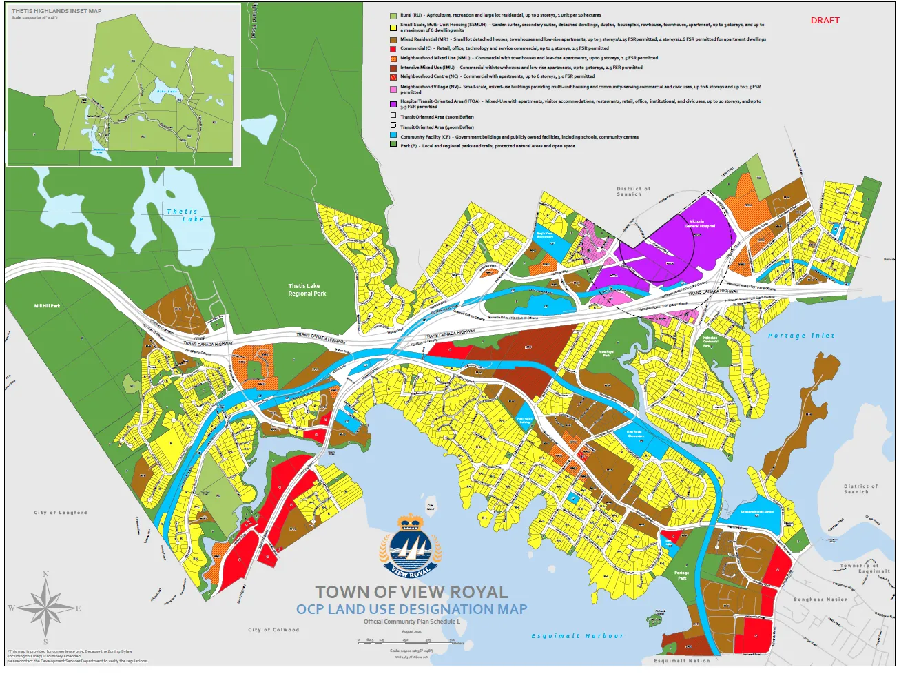
Draft land use map presented to the Committee of the Whole.
Town of View Royal
SCHEDULE 1
TOWN OF VIEW ROYAL
OCP LAND USE DESIGNATION MAP
Official Community Plan Schedule L August 2023
THETIS HIGHLANDS INSET MAP
Land Use Legend
- Rural (RU) - Agriculture, recreation and large lot residential, up to 2 storeys, 1 unit per 10 hectares
- Small-Scale, Multi-Unit Housing (SSMUH) - Garden suites, secondary suites, detached dwellings, duplex, houseplex, rowhouse, townhouse, apartment, up to 3 storeys, and up to a maximum of 6 dwelling units
- Mixed Residential (MR) - Small lot detached houses, townhouses and low-rise apartments, up to 3 storeys/1.25 FSR permitted; 4 storeys/1.6 FSR permitted for apartment dwellings
- Commercial (C) - Retail, office, technology and service commercial, up to 4 storeys, 1.5 FSR permitted
- Neighbourhood Mixed Use (NMU) - Commercial with townhouses and low-rise apartments, up to 3 storeys, 1.5 FSR permitted
- Intensive Mixed Use (IMU) - Commercial with townhouses and low-rise apartments, up to 5 storeys, 2.5 FSR permitted
- Neighbourhood Centre (NC) - Commercial with apartments, up to 6 storeys, 3.0 FSR permitted
- Neighbourhood Village (NV) - Small-scale, mixed-use buildings providing multi-unit housing and community-serving commercial and civic uses, up to 6 storeys and up to 2.5 FSR permitted
- Hospital Transit Oriented Area (HTOA) - Mixed-Use with apartments, visitor accommodations, restaurants, retail, office, institutional, and civic uses, up to 10 storeys, and up to 3.5 FSR permitted
- Transit Oriented Area (200m Buffer)
- Transit Oriented Area (400m Buffer)
- Community Facility (CF) - Government buildings and publicly owned facilities, including schools, community centres
- Park (P) - Local and regional parks and trails, protected natural areas and open space
*This map is provided for convenience only. Because the Zoning Bylaw (including this map) is routinely amended, please contact the Development Services Department to verify the regulations.
Page 71
Extracted from: 2025 12 02 Public Hearing Agenda - Agenda - Pdf