Appendix
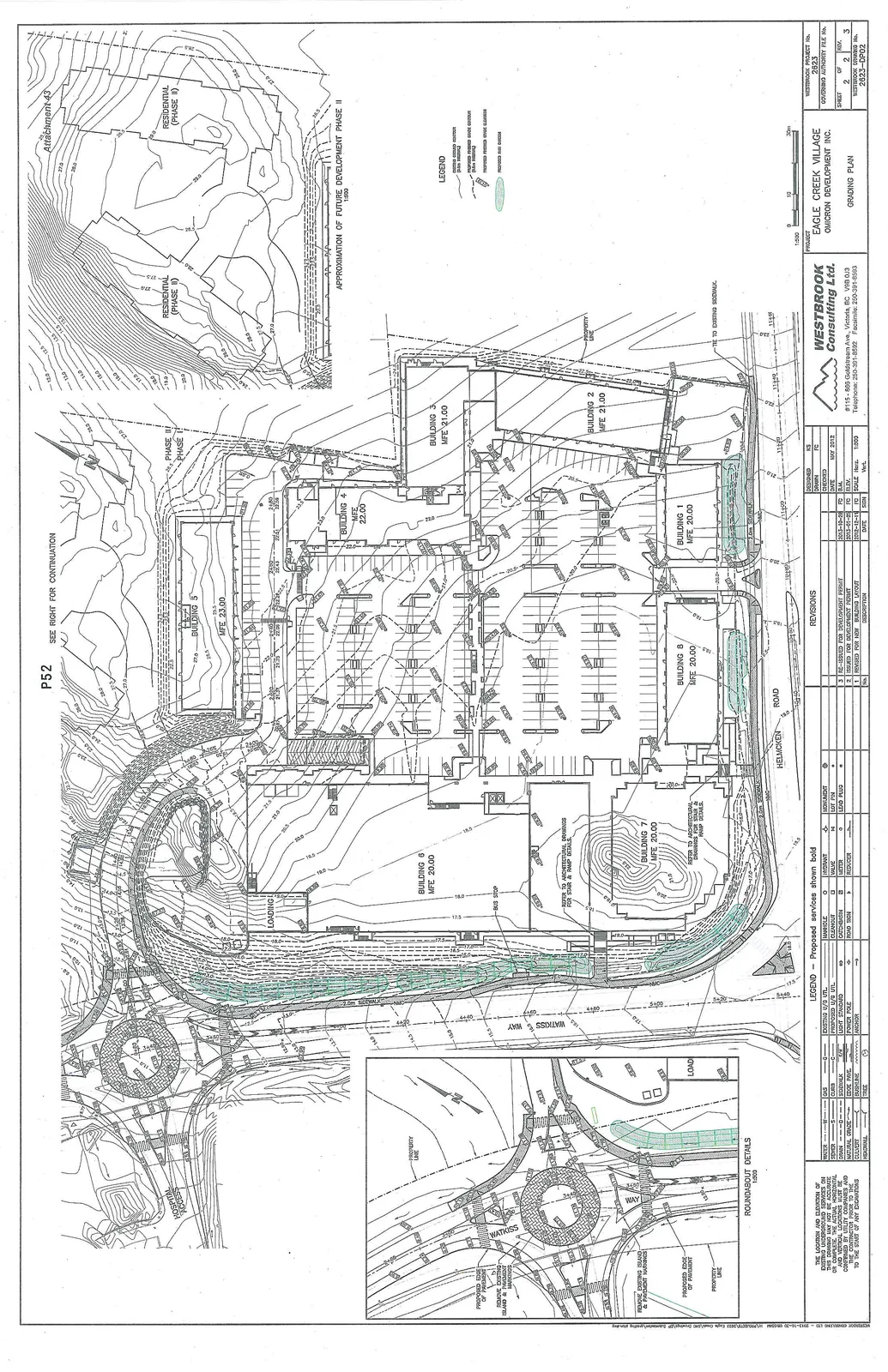
Eagle Creek Village Grading Plan (Attachment 43)
December 10, 2013Page 571 section
Engineering plan detailing site contours, proposed grades, and building elevations for the Phase I development.
Drawing 2823-DP02Building 1 through 8 elevations
EAGLE CREEK VILLAGE - GRADING PLAN
Project Information
- Project: EAGLE CREEK VILLAGE
- Developer: OMICRON DEVELOPMENT INC.
- Consulting Firm: WESTBROOK Consulting Ltd.
- Address: #115 - 555 Goldstream Ave., Victoria, BC V8B 0J3
- Telephone: 250-391-8592 | Facsimile: 250-391-8593
- Project No.: 2823
- Sheet: 2 of 3
- Drawing No.: 2823-DP02
- Date: MAY 2012
- Scale Horz.: 1:500
Revisions
| No. | Description | Date | Sign |
|---|---|---|---|
| 1 | REVISED FOR NEW BUILDING LAYOUT | 2012-10-18 | FC |
| 2 | ISSUED FOR DEVELOPMENT PERMIT | 2013-01-25 | FC |
| 3 | RE-ISSUED FOR DEVELOPMENT PERMIT | 2013-10-25 | FC |
Legend
Proposed services shown bold
- WATER: Solid line
- SEWER: Dashed line with "S"
- DRAIN: Dashed line with "D"
- NATURAL GRADE: Dotted line
- CULVERT: Double parallel lines
- HEADWALL: Rectangular symbol at pipe end
- GAS: Line with "G"
- CURB: Double line
- SIDEWALK: Stippled/hatched area
- EDGE PAVE.: Dashed line
- BUSHLINE: Scalloped line
- TREE: Circular foliage symbol
- EXISTING U/S UTIL.: Thin line
- PROPOSED U/S UTIL.: Bold line
- LIGHT STANDARD: Circle with four rays
- POWER POLE: Circle with cross
- ANCHOR: Arrow symbol
- MANHOLE: Circle
- CLEANOUT: Square
- CATCHBASIN: Grated rectangle
- ROAD SIGN: Square on post symbol
- HYDRANT: Circle with internal cross
- VALVE: Bowtie symbol
- METER: Square with "M"
- REDUCER: Triangular symbol
- MONUMENT: Diamond symbol
- LOT PIN: Circle with dot
- LEAD PLUG: Small square
Grading Legend
- Existing ground contour (0.5m interval): Light dashed line
- Proposed finished grade contour (0.2m interval): Bold dashed line
- Proposed finished grade elevation: Numerical value (e.g., +20.00)
- Proposed park contour: Green dashed line
General Notes
THE LOCATION AND ELEVATION OF EXISTING UNDERGROUND SERVICES ON THIS DRAWING MAY NOT BE ACCURATE OR COMPLETE. THE ACTUAL HORIZONTAL AND VERTICAL LOCATIONS MUST BE CONFIRMED BY UTILITY COMPANIES AND THE CONTRACTOR PRIOR TO THE TO THE START OF ANY EXCAVATIONS.
Site Details
Building Finished Elevations (MFE)
- Building 1: MFE 20.00
- Building 2: MFE 21.00
- Building 3: MFE 21.00
- Building 4: MFE 22.00
- Building 5: MFE 23.00
- Building 6: MFE 20.00
- Building 7: MFE 20.00 (Refer to architectural drawings for stair & ramp details)
- Building 8: MFE 20.00 (Refer to architectural drawings for stair & ramp details)
Infrastructure and Features
- Watkiss Way: Access road running north-south on the west side of the site.
- Helmcken Road: Access road running east-west on the south side of the site.
- Hospital Access: Located at the northwest corner of the site.
- Loading Area: Located behind Building 6.
- Bus Stop: Located on Watkiss Way.
Page 57
Extracted from: 2013 12 10 Council Agenda