Staff Report: Development Permit Application 2013/16 – 138 St. Giles Street
Recommendation to approve a development permit and subdivision at 138 St. Giles Street, including variances for lot width and road frontage.
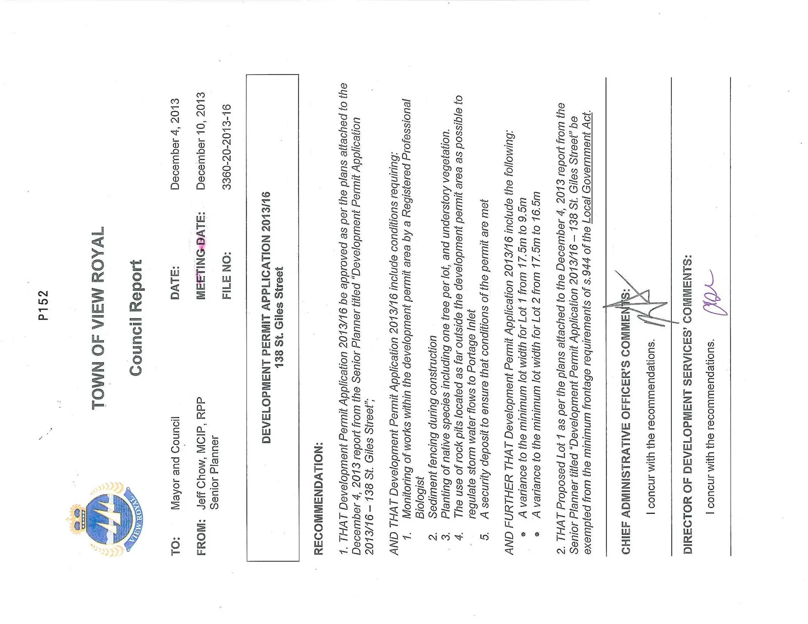
TOWN OF VIEW ROYAL Council Report
TO: Mayor and Council DATE: December 4, 2013 FROM: Jeff Chow, MCIP, RPP, Senior Planner MEETING DATE: December 10, 2013 FILE NO: 3360-20-2013-16
DEVELOPMENT PERMIT APPLICATION 2013/16
138 St. Giles Street
RECOMMENDATION:
- THAT Development Permit Application 2013/16 be approved as per the plans attached to the December 4, 2013 report from the Senior Planner titled "Development Permit Application 2013/16 – 138 St. Giles Street";
AND THAT Development Permit Application 2013/16 include conditions requiring:
- Monitoring of works within the development permit area by a Registered Professional Biologist
- Sediment fencing during construction
- Planting of native species including one tree per lot, and understory vegetation.
- The use of rock pits located as far outside the development permit area as possible to regulate storm water flows to Portage Inlet
- A security deposit to ensure that conditions of the permit are met
AND FURTHER THAT Development Permit Application 2013/16 include the following:
- A variance to the minimum lot width for Lot 1 from 17.5m to 9.5m
- A variance to the minimum lot width for Lot 2 from 17.5m to 16.5m
- THAT Proposed Lot 1 as per the plans attached to the December 4, 2013 report from the Senior Planner titled "Development Permit Application 2013/16 – 138 St. Giles Street" be exempted from the minimum frontage requirements of s.944 of the Local Government Act.
CHIEF ADMINISTRATIVE OFFICER'S COMMENTS:
I concur with the recommendations.
DIRECTOR OF DEVELOPMENT SERVICES' COMMENTS:
I concur with the recommendations.
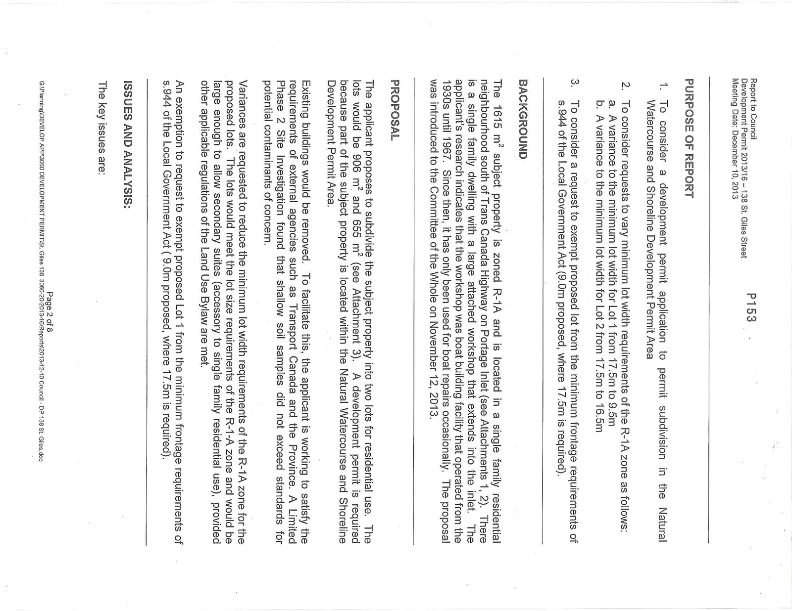
PURPOSE OF REPORT
- To consider a development permit application to permit subdivision in the Natural Watercourse and Shoreline Development Permit Area
- To consider requests to vary minimum lot width requirements of the R-1A zone as follows: a. A variance to the minimum lot width for Lot 1 from 17.5m to 9.5m b. A variance to the minimum lot width for Lot 2 from 17.5m to 16.5m
- To consider a request to exempt proposed lot from the minimum frontage requirements of s.944 of the Local Government Act (9.0m proposed, where 17.5m is required).
BACKGROUND
The 1615 m² subject property is zoned R-1A and is located in a single family residential neighbourhood south of Trans Canada Highway on Portage Inlet (see Attachments 1, 2). There is a single family dwelling with a large attached workshop that extends into the inlet. The applicant’s research indicates that the workshop was boat building facility that operated from the 1930s until 1967. Since then, it has only been used for boat repairs occasionally. The proposal was introduced to the Committee of the Whole on November 12, 2013.
PROPOSAL
The applicant proposes to subdivide the subject property into two lots for residential use. The lots would be 906 m² and 655 m² (see Attachment 3). A development permit is required because part of the subject property is located within the Natural Watercourse and Shoreline Development Permit Area.
Existing buildings would be removed. To facilitate this, the applicant is working to satisfy the requirements of external agencies such as Transport Canada and the Province. A Limited Phase 2 Site Investigation found that shallow soil samples did not exceed standards for potential contaminants of concern.
Variances are requested to reduce the minimum lot width requirements of the R-1A zone for the proposed lots. The lots would meet the lot size requirements of the R-1A zone and would be large enough to allow secondary suites (accessory to single family residential use), provided other applicable regulations of the Land Use Bylaw are met.
An exemption to request to exempt proposed Lot 1 from the minimum frontage requirements of s.944 of the Local Government Act (9.0m proposed, where 17.5m is required).
ISSUES AND ANALYSIS:
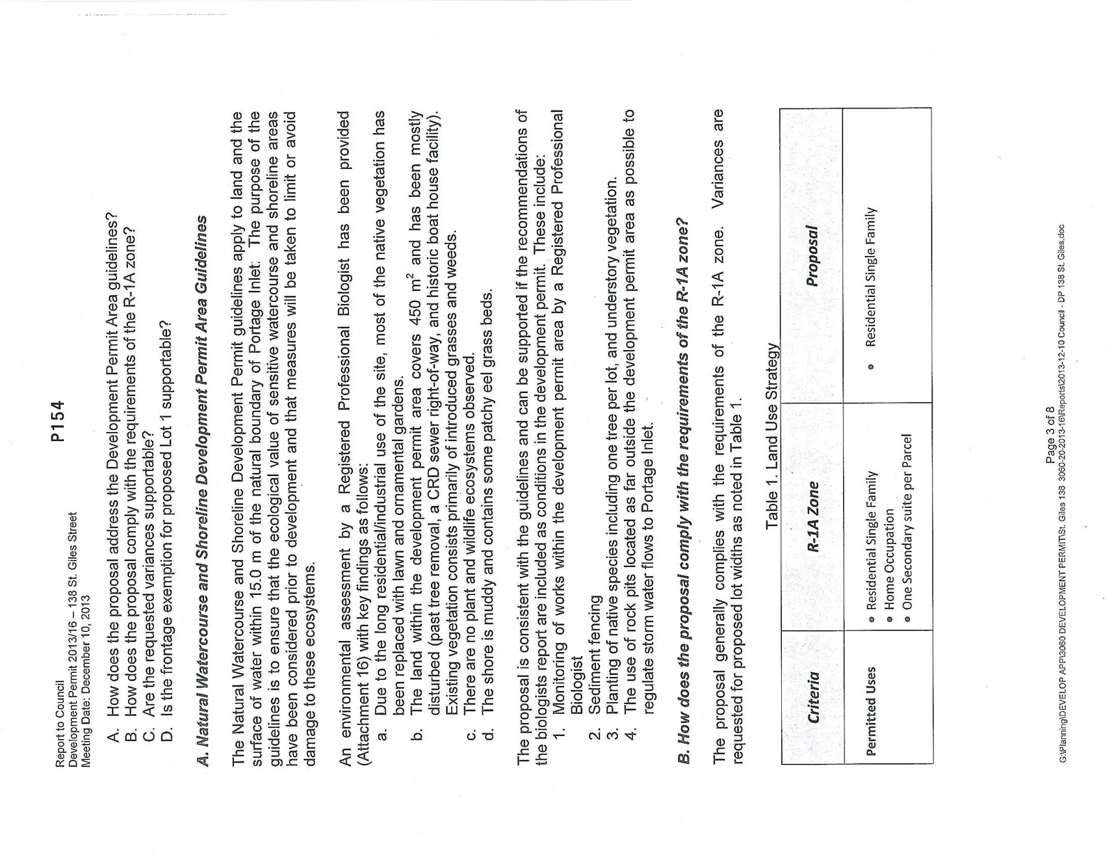
The key issues are: A. How does the proposal address the Development Permit Area guidelines? B. How does the proposal comply with the requirements of the R-1A zone? C. Are the requested variances supportable? D. Is the frontage exemption for proposed Lot 1 supportable?
A. Natural Watercourse and Shoreline Development Permit Area Guidelines
The Natural Watercourse and Shoreline Development Permit guidelines apply to land and the surface of water within 15.0 m of the natural boundary of Portage Inlet. The purpose of the guidelines is to ensure that the ecological value of sensitive watercourse and shoreline areas have been considered prior to development and that measures will be taken to limit or avoid damage to these ecosystems.
An environmental assessment by a Registered Professional Biologist has been provided (Attachment 16) with key findings as follows: a. Due to the long residential/industrial use of the site, most of the native vegetation has been replaced with lawn and ornamental gardens. b. The land within the development permit area covers 450 m² and has been mostly disturbed (past tree removal, a CRD sewer right-of-way, and historic boat house facility). Existing vegetation consists primarily of introduced grasses and weeds. c. There are no plant and wildlife ecosystems observed. d. The shore is muddy and contains some patchy eel grass beds.
The proposal is consistent with the guidelines and can be supported if the recommendations of the biologists report are included as conditions in the development permit. These include:
- Monitoring of works within the development permit area by a Registered Professional Biologist
- Sediment fencing
- Planting of native species including one tree per lot, and understory vegetation.
- The use of rock pits located as far outside the development permit area as possible to regulate storm water flows to Portage Inlet.
B. How does the proposal comply with the requirements of the R-1A zone?
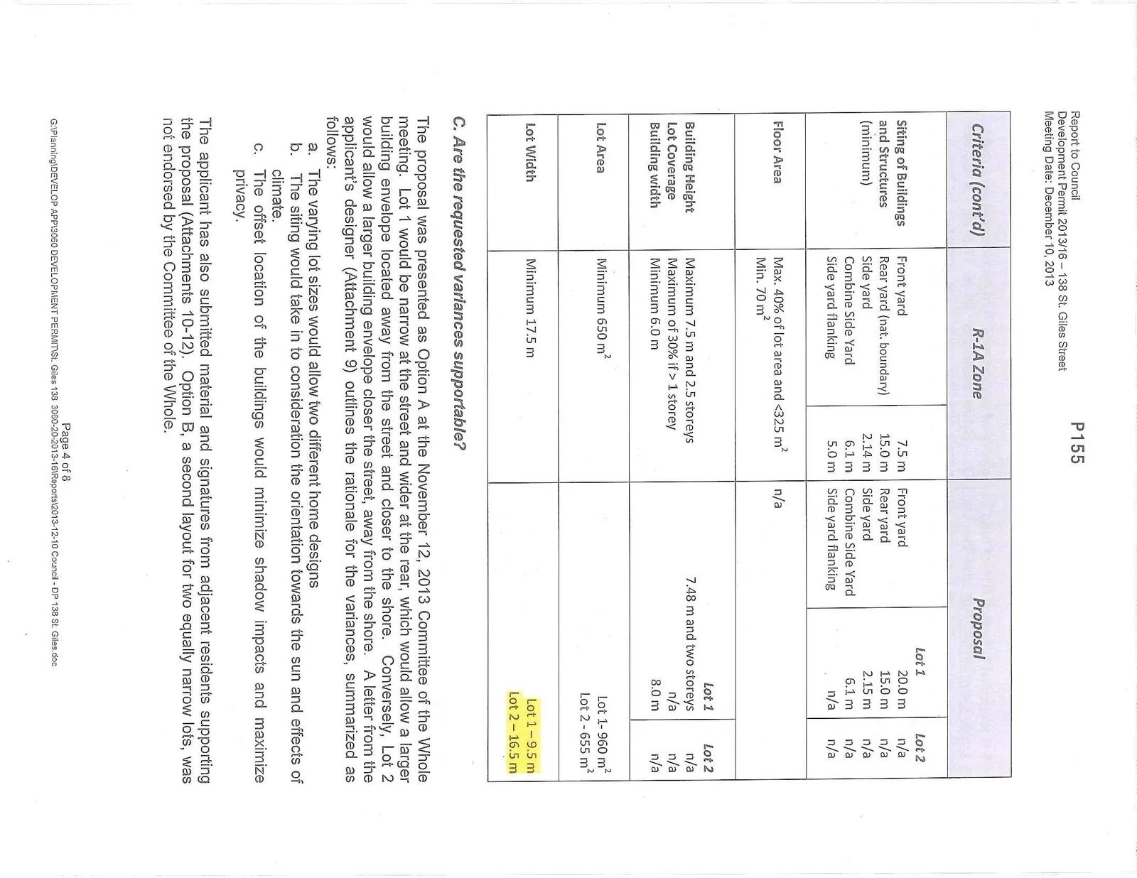
The proposal generally complies with the requirements of the R-1A zone. Variances are requested for proposed lot widths as noted in Table 1.
Table 1. Land Use Strategy
| Criteria | R-1A Zone | Proposal |
|---|---|---|
| Permitted Uses | • Residential Single Family • Home Occupation • One Secondary suite per Parcel |
• Residential Single Family |
| Siting of Buildings and Structures (minimum) | Front yard: 7.5 m Rear yard (nat. boundary): 15.0 m Side yard: 2.14 m Combine Side Yard: 6.1 m Side yard flanking: 5.0 m |
Lot 1 Front yard: 20.0 m Rear yard: 15.0 m Side yard: 2.15 m Combine Side Yard: 6.1 m Side yard flanking: n/a Lot 2 Front yard: n/a Rear yard: n/a Side yard: n/a Combine Side Yard: n/a Side yard flanking: n/a |
| Floor Area | Max. 40% of lot area and <325 m² Min. 70 m² |
n/a |
| Building Height | Maximum 7.5 m and 2.5 storeys | Lot 1: 7.48 m and two storeys Lot 2: n/a |
| Lot Coverage | Maximum of 30% if > 1 storey | Lot 1: n/a Lot 2: n/a |
| Building width | Minimum 6.0 m | Lot 1: 8.0 m Lot 2: n/a |
| Lot Area | Minimum 650 m² | Lot 1: 960 m² Lot 2: 655 m² |
| Lot Width | Minimum 17.5 m | Lot 1: 9.5 m Lot 2: 16.5 m |
C. Are the requested variances supportable?
The proposal was presented as Option A at the November 12, 2013 Committee of the Whole meeting. Lot 1 would be narrow at the street and wider at the rear, which would allow a larger building envelope located away from the street and closer to the shore. Conversely, Lot 2 would allow a larger building envelope closer the street, away from the shore. A letter from the applicant’s designer (Attachment 9) outlines the rationale for the variances, summarized as follows: a. The varying lot sizes would allow two different home designs b. The siting would take in to consideration the orientation towards the sun and effects of climate. c. The offset location of the buildings would minimize shadow impacts and maximize privacy.
The applicant has also submitted material and signatures from adjacent residents supporting the proposal (Attachments 10-12). Option B, a second layout for two equally narrow lots, was not endorsed by the Committee of the Whole.
D. Frontage Exemption for proposed Lot 1
Lot 1 is proposed to have 9.0 m of road frontage of where the minimum requirement pursuant to the Local Government Act and the Land Use Bylaw 1990, No. 35 is 17.5 m. A Council resolution to exempt the lot from this requirement must be made if the proposed lot layout is supported. Lot 2 would have over 21 m of road frontage, which exceeds the minimum requirement.
RECOMMENDATION:
- THAT Development Permit Application 2013/16 be approved as per the plans attached to the December 4, 2013 report from the Senior Planner titled "Development Permit Application 2013/16 – 138 St. Giles Street";
AND THAT Development Permit Application 2013/16 include conditions requiring:
- Monitoring of works within the development permit area by a Registered Professional Biologist
- Sediment fencing during construction
- Planting of native species including one tree per lot, and understory vegetation.
- The use of rock pits located as far outside the development permit area as possible to regulate storm water flows to Portage Inlet
- A security deposit to ensure that conditions of the permit are met
AND FURTHER THAT Development Permit Application 2013/16 include the following:
- A variance to the minimum lot width for Lot 1 from 17.5m to 9.5m
- A variance to the minimum lot width for Lot 2 from 17.5m to 16.5m
- THAT Proposed Lot 1 as per the plans attached to the December 4, 2013 report from the Senior Planner titled "Development Permit Application 2013/16 – 138 St. Giles Street" be exempted from the minimum frontage requirements of s.944 of the Local Government Act.
SUBMITTED BY: Jeff Chow, MCIP, RPP, Senior Planner
REVIEWED BY: Lindsay Chase, MCIP, RPP, Director of Development Services
ATTACHMENTS
- Subject Property Map
- Subject Property Orthophoto
- Proposed Subdivision Plan ("Option A")
- Letter to Committee of the Whole from applicant Whitney Garside dated October 30, 2013
- Email correspondence between staff and applicant dated October 21, 2013
- Subdivision Layout - Option A
- Subdivision Layout - Option B
Document Images
(5)