Attachment 17. Natural Watercourse and Shoreline Memo
Technical memo assessing the environmental impact of the proposed development on the Millstream Creek estuary.
MEMO
To: Dean Paterson, Architect AIBC, MRAIC From: Wm. Patrick Lucey, Sr. Aquatic Ecologist, R.P. Bio. Sarah Karkanis, Aquatic Technical Specialist, M.Sc. Re: Six Mile Furniture Natural Watercourse and Shoreline DP Date: May 2, 2014 File: Working Files:Projects (server):Six Mile Furniture:FINALSixMile_shorelineareaDP_140502.docx
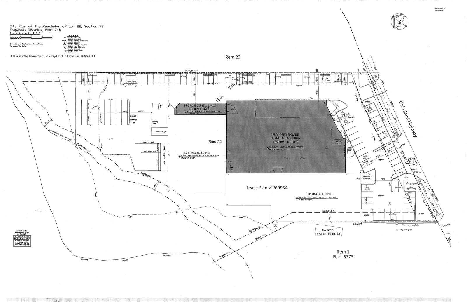
Thank you for contacting us regarding the proposed changes at the Six Mile Furniture View Royal site (1644 & 1652 Old Island Highway). It is my understanding that the current proposal on the property includes the construction of an extension to an existing commercial building toward Old Island Highway and the development of additional parking on the north end of the lot (site plan appended). This technical memorandum is designed to provide technical advice on meeting, or exceeding the standard of care as defined in the View Royal OCP for a Natural Watercourse and Shoreline Permit Area.
I have reviewed the View Royal OCP guidelines related to your property location with the proposed lot alterations in mind. Based upon Schedule Q, along with a site visit to confirm existing landscape features, the subject property falls within the Natural Watercourse and Shoreline Areas Development Permit Area. This DP area is triggered by the presence of Millstream Creek along the north and west property boundary and the fact that the proposed works do not fall under a permit exemption.
A field site visit was conducted by Tracy Motyer (Field Technician) on May 1, 2014 to assess the type of watercourse along with any other pertinent features on this subject site. The Millstream Creek estuary is present beyond the north and western property boundary. The site is relatively flat with a steep bank leading down to the estuary with slopes in excess of 30%. The majority of the site has been previously cleared with the exception of the slope and an asphalt and gravel parking area extends to the top of bank. The lower portion of the slope (roughly ¾ of the slope) is well vegetated with young and middle-aged conifers with a dense shrub understorey. The upper portion of the slope (roughly ¼ of the slope) appears to be constructed out of large riprap boulders now covered in blackberry brambles; it is likely backfilled to create the flat parking site above. The vegetation on the slope appears to be in good health and there were no obvious signs of instability (i.e. buttress wood or slumps).
DP Area General Guidelines
Below is a list of the DP area General Guidelines provided by View Royal (in italics) followed by a statement on how it applies to the subject property based on the site visit and plan review.
i. Development in freshwater riparian areas – e.g. adjacent to streams, lakes, wetlands and other freshwater watercourses –must comply with the requirements of the Riparian Area Regulations.
During the site assessment silverweed (Potentilla anserina ssp. pacifica) which typically occur near the sea, and tidal mud flats were observed (Figure 1 & 2). Furthermore, the area had a distinctly marine smell. According to the Riparian Area Regulation, the “Regulation does not apply to marine or estuarine shorelines… The boundary between freshwater habitats and estuarine habitats is considered to be the upstream extent of tidal influence (Riparian Area Regulation Schedule Assessment Methods. Version 3.3. April 2006. Page 11).” Due to the tidal influence upstream and downstream of the site, the Riparian Area Regulation does not apply; however, this area is considered to be tidal shoreline (Figure 3).
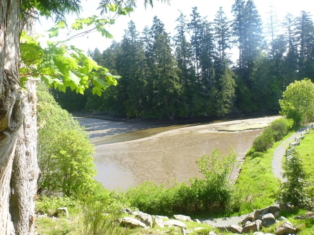
Figure 1. Photograph taken from across Millstream Creek at Duffus Trail Park looking toward the subject property. The tidally influenced mud flats are apparent at low tide. Note also the fully vegetated shoreline and slope on the subject property.
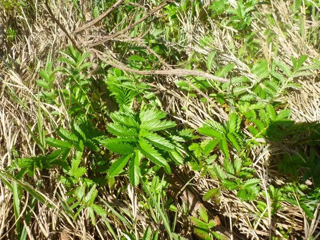
Figure 2. A photograph of the silverweed observed along the shoreline on the opposite bank of Millstream Creek from the subject property. Further evidence that this area of Millstream Creek is tidally influenced.
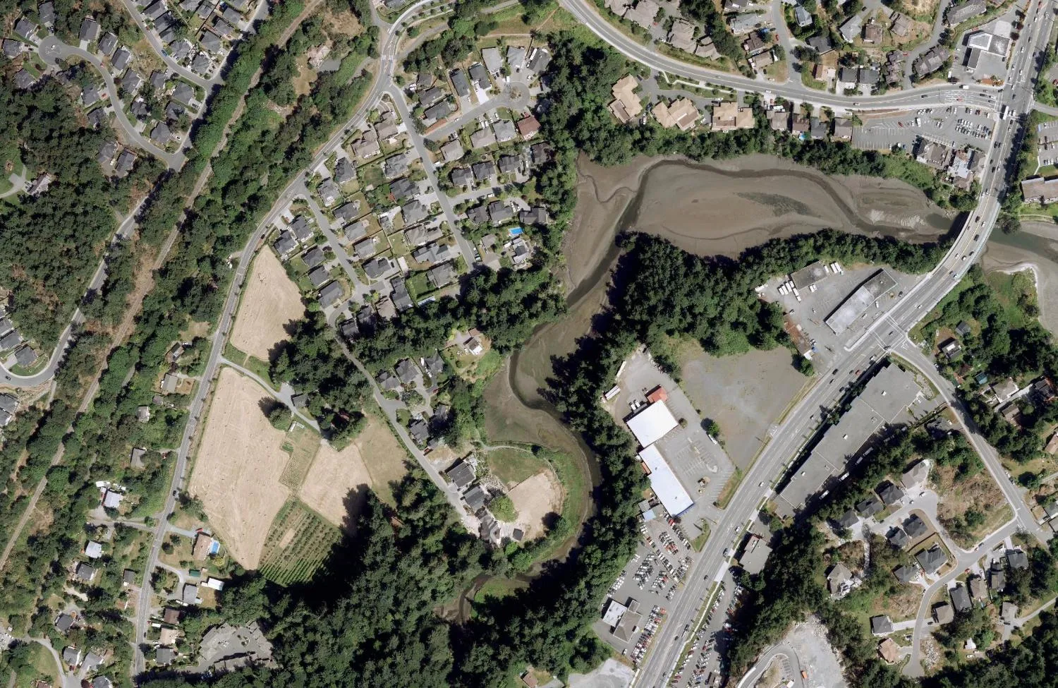
Figure 3. Location of subject property (red polygon). Note the presence of tidally influenced mud flats (yellow arrows) along Millstream Creek upstream and downstream of the property. This tidal influence means the Riparian Area Regulation does not apply. The photographs in Figures 1 and 2 were taken at Duffus Trail Park. (Image Source: CRD Regional Community Atlas).
ii. Development of riparian and shoreline areas should be limited and not negatively impact the ecological health of the immediate area or impede public access.
Public access to the shoreline is not proposed at this location. The slope to the estuary on this side is extremely steep. A geotechnical assessment of the slope is recommended.
iii. Retention of existing healthy riparian and shoreline vegetation should be maximized with any paths, structures or other constructed areas sited to minimize impact on trees and sensitive areas.
This site has been previously cleared and consists of paved surfaces and buildings to the top of the bank (Figure 4). The top of the bank and slope down to the estuary are currently well vegetated with a conifer canopy of young and medium aged trees, with a shrub understory. It is recommended that this vegetation be retained and unaltered. Any disturbance of this marine estuarine foreshore vegetation would require authorization from Federal Fisheries.
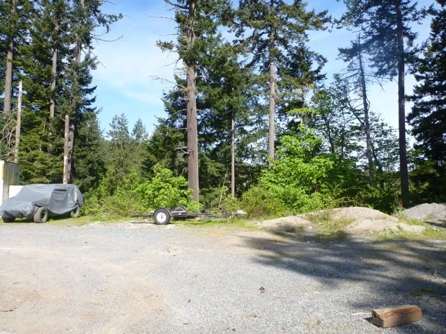
Figure 4. Photograph from the current edge of pavement on the north end of the subject property. The proponents propose to pave the cleared area for additional parking. The vegetated top of bank and slope will be retained.
iv. Restoration of riparian and shoreline vegetation and habitat, including removal of invasive species, is encouraged for all properties within this Development Permit Area. Development should result in a net increase in native vegetation in almost all circumstances including trees, shrubs and grasses.
Removal of the vegetation at the top of the bank and on the slope is not proposed as part of this project. Himalayan blackberry at the edge of the paved surfaces should be removed if there is no risk to slope stability. It should be noted that the edge of the foreshore vegetation, adjacent to the existing gravel parking surface, is a transition zone and typically subject to invasive species dominating the transition edge. Long-term management of such invasives is a difficult task. Our initial assessment of the north-facing foreshore slope plant community revealed low invasive species numbers.
Previous development of this site has resulted in paved and cleared surfaces to the top of the bank. These areas are upslope of the top of bank and do not appear to have impacted the shoreline which is well below the top of the bank. Site changes are not proposed to extend beyond the previously cleared area nor beyond the top of the bank. The 15m zone from the natural boundary to the top of the bank is fully vegetated and no restoration is required (Figure 5). However, care should be taken to not negatively impact the vegetated slope by clearing, compacting, or stormwater mis-management. Given the proposed parking will cover the existing disturbed landscape and is intended for use by the general public, construction of a low fence, to a standard acceptable to View Royal is recommended to address programed non-access to the steep slope beyond the parking surface.
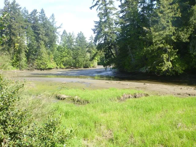
Figure 5. The shoreline of the subject property (right top corner of photograph) is fully vegetated with healthy, native plant species.
vi. Riparian and shoreline area development should sensitively manage storm water, focusing on infiltration and release of storm water in ways and quantities that mimics natural patterns, avoids scouring and erosion and results in storm water free from pollutants.
Storm water could put the stability of the slope at risk if it is not managed appropriately. Stormwater should not be allowed to flow freely over the top of the bank. If possible, existing stormwater drainage facilities should be used to convey treated parking lot stormwater into the estuary, if that is the preferred alignment as prescribed by View Royal engineering staff.
Consideration should be given to separating all existing and future run-off collected from the roofs of the commercial buildings on this site from parking surface run-off. The clean, non-polluted roof run-off can be discharged directly into the estuary, using existing drainage facilities, providing the roof membranes do not contribute pollutants or other toxic materials that would otherwise require treatment.
vii. Shoreline protection measures should be limited to those necessary to prevent damage to existing structures or established uses on adjacent upland.
Shoreline protection measures are not required nor proposed.
viii. In the design of new developments or re-development, the use of soft engineered and innovative alternatives to stabilizing shorelines and preventing erosion, such as bioengineering rather than traditional hard engineered measures should be used.
Shoreline stabilization is not required nor proposed.
ix. Where hard measures can conclusively be shown to be the only means of effectively preventing erosion, they should be designed in consultation with a registered professional biologist, qualified environmental professionals and professional engineers, as appropriate.
Hard measures are not proposed.
x. The preservation and enhancement of native trees and shrub clusters that overhang the waters edge is strongly encouraged as these provide shade, protection and feeding habitat for fish and wildlife.
This site is fully vegetated between the shoreline and the top of bank. Removal of vegetation is not proposed. Parking lot expansion will occur within the already cleared area at the back of the lot.
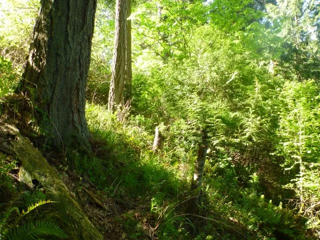
Figure 6. Photograph of the vegetated slope on the subject property.
xi. Any new public pathways or public access should be designed and constructed in consultation with a registered professional biologist or qualified environmental professional, as appropriate, and the Town of View Royal Parks Department.
Public access is not part of this proposal given the steep slopes. It is recommended that a fence be constructed along the top of bank to protect the vegetated slope and reduce any safety risks.
Required Mitigation and Management Plans
As laid out in the Development Permit guidelines (italics), the following items are required as part of the DP for this site :
- Where development is within this Development Permit Area, design details of proposed mitigating measures are to be provided in an environmental management plan prepared by qualified project consultants with the assistance of a registered professional biologist. Minimizing sedimentation and erosion, stabilizing and re-vegetating impacted areas, and monitoring requirements must also be addressed in the management plan.
Based on the current site design, the proponent intends to utilize previously cleared and disturbed areas for the parking lot realignment at the north end of the property. The existing top of bank and slope down to the Millstream Creek estuary shoreline are fully vegetated and no alterations are proposed to this area. Given there are no plans to disturb this vegetation there will likely be no negative impact to the natural conditions of the area as long as erosion is managed during construction and stormwater on-site is managed appropriately. An erosion and sediment control plan must be developed to protect the top of the bank to prevent any movement of sediment down the slope into Millstream Creek for slope stability and water quality purposes. During construction, an environmental monitoring plan must be implemented to document the protection of the top of bank along with erosion and sediment control. One option for streamlining monitoring is to use a mobile application like EnviroCheck. The EnviroCheck App is intended to provide a simple, quick means of conducting a compliance monitoring inspection on your mobile device while at a work site and transmit completed inspection reports via wifi or the cellular phone network. We recommend that the EnviroCheck Mobile App be considered as an appropriate erosion and sediment control monitoring method to meet the standard of care defined by the Department of Fisheries and Oceans to protect the salmonid, and other, fisheries within the highly sensitive Millstream estuary.
No vegetation should be removed from the top of the bank unless required by a Qualified Professional for safety reasons.
- Where development is within this Development Permit Area, a storm water management plan must be prepared by a qualified engineer in consultation with a registered professional biologist.
The stormwater management plan must be designed with the steepness and composition of the slope in mind. If stormwater were to be directly released via surface flow onto the slope, it could result in slope instability and subsequent loss of vegetation. The loss of vegetation could lead to shoreline damage. Furthermore, stormwater is known to be of poor water quality and requires treatment before being released into natural environment such as Millstream Creek. To mitigate these concerns, a stormwater management plan must be developed that does not result in surface run-off directly onto the slope at the north end of the property nor allow for any untreated stormwater to enter Millstream Creek. One option for treating stormwater runoff for from the asphalt parking surfaces would be the construction of bioswales and raingardens.
- Where steep or unstable slopes exist or there is risk of flooding, a report from a geotechnical engineer must be provided.
Given the steep slope on the north side of the property, it is highly recommended that a geotechnical assessment be undertaken if one has not already been done.
THIS PAGE INTENTIONALLY LEFT BLANK
Document Images
(4)