TOWN OF VIEW ROYAL COUNCIL REPORT: ACTIVE TRANSPORTATION NETWORK PLAN UPDATE
Staff report providing an update on the progress of the Active Transportation Network Plan and summarizing findings from the second round of community engagement.
TOWN OF VIEW ROYAL COUNCIL REPORT
TO: Council DATE: February 1, 2023 FROM: Ivan Leung, P.Eng, Director of Engineering & Parks MEETING DATE: February 7, 2023
ACTIVE TRANSPORTATION NETWORK PLAN UPDATE
RECOMMENDATION:
THAT the February 1, 2023 report titled “Active Transportation Network Plan Update” be received for information.
PURPOSE:
The purpose of this report is to update Council on the progress of the Active Transportation Network Plan (“ATNP”) and to summarize the project’s second round of public engagement.
EXECUTIVE SUMMARY:
A second round of public engagement was conducted between early November to mid-December. Its purpose was to invite the public to share feedback on the preliminary network strategies. These strategies were built on the foundation of the Town’s Background Report and the first round of public engagement. This allowed the public to further dial in comments with more focus on key transportation network corridors.
The key takeaways from the second round of engagement were:
- There is a general level of support for the draft vision and goals for the Active Transportation Network Plan, which revolves around providing a connected, compact, and safe network of active transportation facilities that reduces GHG emissions and supports the local economy.
- Of the critical road corridors in the Town, Admirals Road was ranked as the highest priority to improve.
- Of the additional corridor improvements proposed, the top priorities were Helmcken Road north, Watkiss Way east, and Burnside Road west.
- The highest ranked intersections to prioritize were identified as the Admirals Road / Island Hwy intersection and the E&N Trail / Island Hwy / Colwood Interchange intersection.
BACKGROUND AND DISCUSSION:
Council was last apprised of this project at the September 6, 2022 regular Council meeting. The project had just completed Phase 2 at the time and was in the midst of commencing Phase 3.
To date, the Town has completed Phase 3 of the ATNP process and are commencing work on Phase 4:
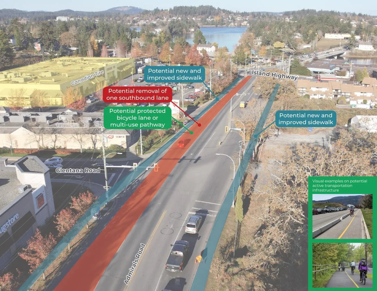
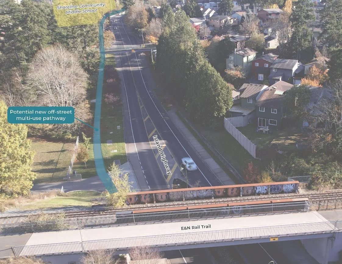
Figure 1: ATNP Progress
The network analysis and preliminary strategies and solutions phase involved identifying potential key improvements and detailing the future network and design recommendations. These strategies and solutions were built on the findings of the Baseline Conditions Report and the first round of public engagement (see What We Heard Report #1).
To confirm and shape the ATNP’s overall network vision, direction and goals, a second round of public engagement was provided. This stage of engagement was important to reaffirm the initial findings and to make adjustments based on comments heard from the community.
It should be highlighted that the purpose of the second round of engagement was to provide more focus on the issues and opportunities for the key corridors identified in previous engagement events. This is not to say that other road corridors were ignored: while roads such as Six Mile Road were not widely identified in the What We Heard Report #2, the actual Active Transportation Network Plan will take a holistic look at the transportation network and will provide guidance to the Town in how to move forward with a cohesive network, including roads such as these.
The What We Heard Report #2 is attached in full. Below are some highlights of the report findings.
Engagement by the Numbers
Two (2) engagement events were provided for this phase:
- Community Bikeshop, an in-person event where members of the public explored the state of all transportation infrastructure across View Royal on bikes.
- Three events took place on the weekend from Nov. 5 to Nov. 6, 2022
- A total of 29 participants engaged in this activity.
- Online Survey #2, targeted towards View Royal residents and those who work in the Town.
- The survey took place between Nov. 24, 2022, to Dec. 15, 2022
- A total of 337 responses were received, mostly from residents of View Royal (73%)
- Among the View Royal residents, the top three neighbourhoods that responded were Helmcken (33%), Thetis (22%) and Craigflower (16%)
- Approximately 71% of respondents were between 30-59 years of age.
Vision and Goals
The survey indicated that most respondents were supportive of the draft vision statement for active transportation in View Royal (83%). The vision statement aligned with the Town’s overarching Vision, Mission and Values, Strategic Plan and the 2018 Official Community Plan Update.
The survey also indicated strong support of the draft goals for active transportation in View Royal (86%). These goals were derived from past OCP update reviews and themes from the first round of engagement. These goals are found in Section 4.1.2 of What We Heard Report #2.
Short Term Priority Projects and Critical Corridor Improvements (1-7 years)
Three (3) corridors were flagged from the first round of public engagement as needing the most safety improvements for active transportation users: Admirals Road, Island Highway, and the Helmcken Road Interchange:
Admirals Road – from Hallowell Road to Admirals Road (Highest Ranked)
The proposed improvements for this segment included the removal of a southbound lane to provide space for a bi-directional cycling facility or multi-use path:
Figure 2: Admirals Road Potential Improvements
While a preliminary desktop study was completed to determine the feasibility of reducing a southbound travel lane, additional traffic impact studies will be required at detail design to better inform on the final design. Additional consultation with the Ministry of Transportation and Infrastructure (MoTI) will also be required at the detail design stage.
Most respondents were supportive of the proposed improvements (72% support or strongly support while 19% either somewhat or strongly opposed). Feedback from the bikeshop also reiterated the need to improve safety for people walking, cycling and rolling on this corridor.
Island Highway – from Admirals Road to the E&N Regional Trail
The proposed critical improvements to this corridor included an off street multi use pathway on the north side of the road and a new ramp to improve access to the E&N Rail Trail for pedestrians and cyclists.
Figure 3: Island Highway Potential Improvements
Most respondents were supportive of the proposed improvements (84% support or strongly support while 7% either somewhat or strongly opposed).
Bikeshop participants were enthusiastic to hear of proposed improvements along the Island Highway to enhance connectivity to the E&N Rail Trail.
Additional consultation with Island Rail will be required at the detail design stage.
Helmcken Road Interchange
The proposed critical improvements to this corridor included the removal of a southbound travel lane to provide space for a bi-directional cycling facility or multi-use path.
While a preliminary desktop study was completed to determine the feasibility of reducing a southbound travel lane, additional traffic impact studies will be required at detail design to better inform on the final design. Additional consultation with MoTI will also be required at the detail design stage.
More respondents were supportive of the proposed improvements (65% support or strongly support while 23% either somewhat or strongly opposed).
Document Images
(6)

Bar chart and graph icon representing Phase 1: Project Initiation & Baseline Conditions

Microphone icon representing Phase 2: Initial Stakeholder & Public Engagement

Sliders icon representing Phase 3: Network Analysis, Preliminary Strategies & Solutions

Clipboard and pencil icon representing Phase 4: Draft Plan

Checklist icon representing Phase 5: Plan Finalization