Appendix
Schedule 1: Map (Repeat)
November 18, 2025Page 631 section
SCHEDULE 1
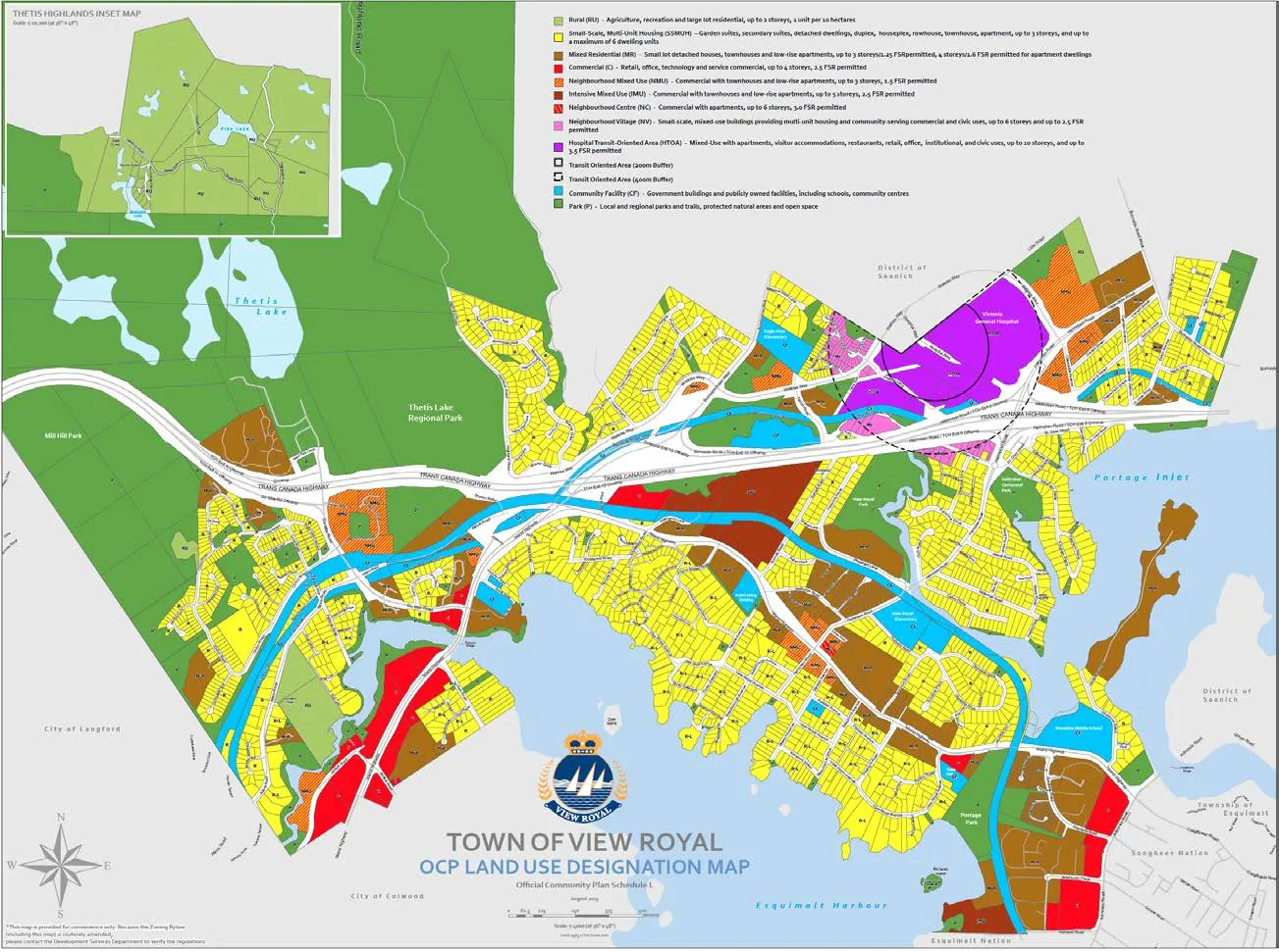
TOWN OF VIEW ROYAL OCP LAND USE DESIGNATION MAP
Official Community Plan Schedule 1 August 2024
Legend
- Rural (RU) – Agriculture, recreation and large lot residential; up to 1 storey, 1 unit per 10 hectares
- Small-Scale, Multi-Unit Housing (SSMUH) – Garden suites, secondary suites, detached dwellings, duplex, houseplex, rowhouse, townhouse, apartment, up to 3 storeys, and up to a maximum of 6 dwelling units
- Mixed Residential (MR) – Small lot detached houses, townhouses and low-rise apartments, up to 3 storeys/1.25 FSR permitted; 4 storeys/1.6 FSR permitted for apartment dwellings
- Commercial (C) – Retail, office, technology and service commercial; up to 4 storeys, 2.5 FSR permitted
- Neighbourhood Mixed Use (NMU) – Commercial with townhouses and low-rise apartments, up to 3 storeys, 1.5 FSR permitted
- Intensive Mixed Use (IMU) – Commercial with townhouses and low-rise apartments, up to 5 storeys, 2.5 FSR permitted
- Neighbourhood Centre (NC) – Commercial with apartments, up to 6 storeys, 3.0 FSR permitted
- Neighbourhood Village (NV) – Small-scale, mixed-use buildings providing multi-unit housing and community-serving commercial and civic uses, up to 4 storeys and up to 1.1 FSR permitted
- Hospital Transit Oriented Area (HTOA) – Mixed Use with apartments, visitor accommodations, restaurants, retail, office, institutional, and civic uses, up to 10 storeys, and up to 3.5 FSR permitted
- Transit Oriented Area (200m Buffer)
- Transit Oriented Area (400m Buffer)
- Community Facility (CF) – Government buildings and publicly owned facilities, including schools, community centres
- Park (P) – Local and regional parks and trails, protected natural areas and open space
Page 63
Extracted from: 2025 11 18 Council Agenda - Agenda - Pdf