Appendix
Schedule 1 Map (Item 4.b.2 Attachment)
November 18, 2025Page 901 section
Updated OCP Land Use Designation Map.
SCHEDULE 1
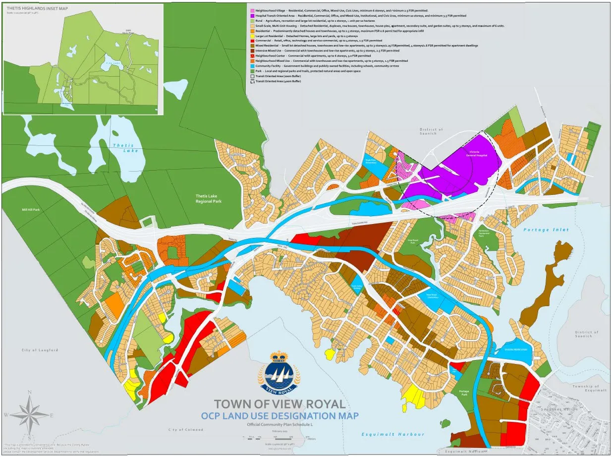
TOWN OF VIEW ROYAL OCP LAND USE DESIGNATION MAP
Official Community Plan Schedule L
Legend
- Neighbourhood Village – Residential, Commercial, Office, Mixed-Use, Civic Uses, minimum 6 storeys, and minimum 2.5 FSR permitted.
- Hospital Transit-Oriented Area – Residential, Commercial, Office, and Mixed-Use, Institutional, and Civic Uses, minimum six storeys, and minimum 3.5 FSR permitted
- Rural – Agriculture, recreation and large lot residential, up to 2 storeys, 1 unit per 0.4 hectares
- Small-Scale, Multi-Unit Housing – Detached Residential, duplexes, row houses, townhouses, house-plex, apartment, secondary suite, and garden suites, up to 3 storeys, and maximum of 6 units.
- Residential – Predominantly detached houses and townhouses, up to 3 storeys, maximum FSR 0.8 permitted for appropriate infill
- Large Lot Residential – Detached Homes, large lots and yards, up to 2.5 storeys
- Commercial – Retail, office, technology and service commercial, up to 4 storeys, 2.5 FSR permitted
- Mixed Residential – Small lot detached houses, townhouses and low-rise apartments, up to 3 storeys, 1.5 FSR permitted, 4 storeys, 2 FSR permitted for apartment dwellings
- Intensive Mixed Use – Commercial with townhouses and low-rise apartments, up to 5 storeys, 2.5 FSR permitted
- Neighbourhood Center – Commercial with apartments, up to 6 storeys, 3.0 FSR permitted
- Neighbourhood Mixed Use – Commercial with townhouses and low-rise apartments, up to 3 storeys, 1.5 FSR permitted
- Community Facility – Government buildings and publicly owned facilities, including schools, community centres
- Park – Local and regional parks and trails, protected natural areas and open space
- Transit Oriented Area (400m Buffer)
- Transit Oriented Area (800m Buffer)
Map Insets and Labels
- THETIS HIGHLANDS INSET MAP
- Thetis Lake
- Thetis Lake Regional Park
- Mill Hill Park
- Portage Inlet
- Esquimalt Harbour
- Victoria General Hospital
- District of Saanich
- City of Langford
- City of Colwood
- Township of Esquimalt
Page 90
Extracted from: 2025 11 18 Council Agenda - Agenda - Pdf