Attachment 17. Servicing Plan
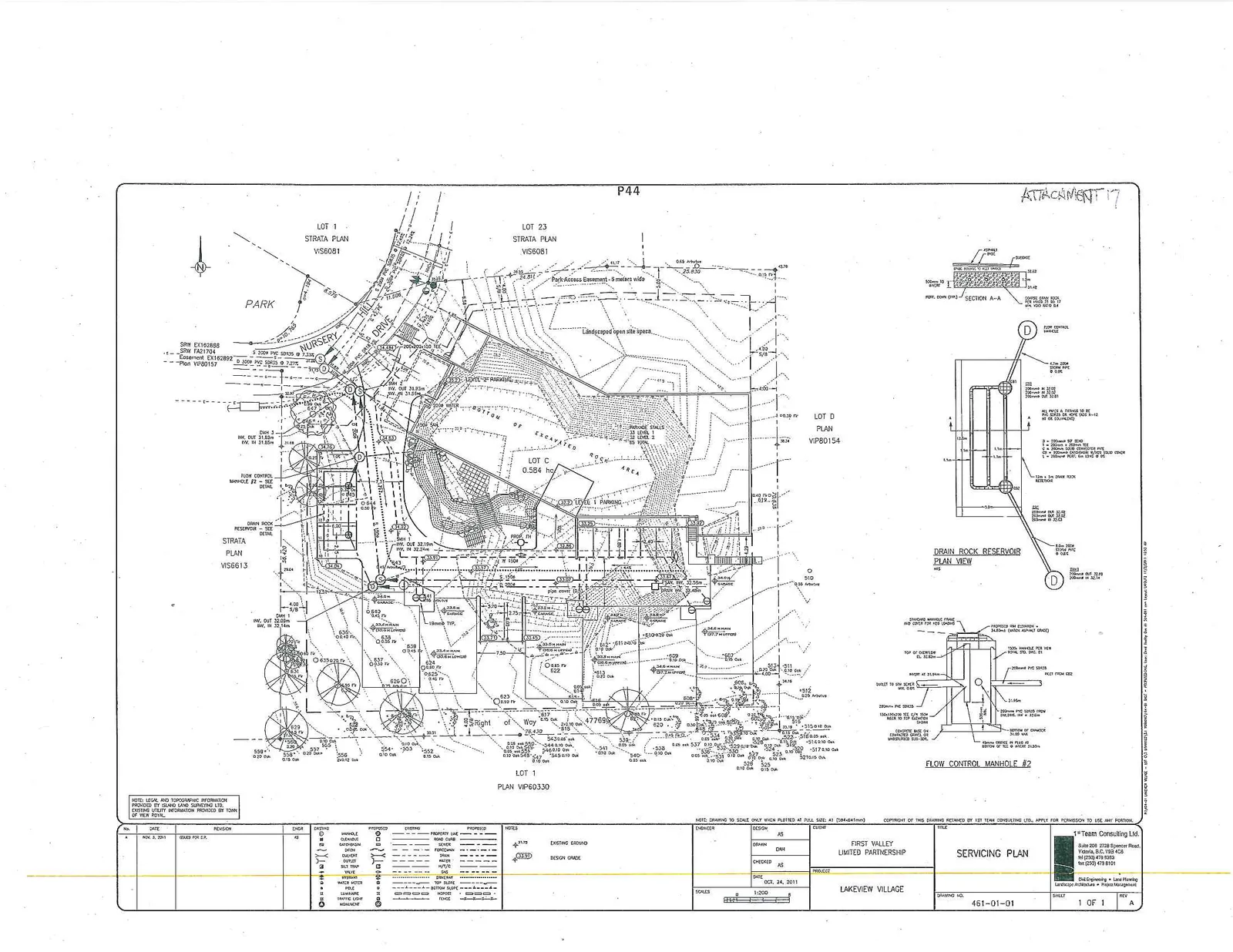
Engineering drawing detailing the underground utilities and stormwater retention reservoir for the site.
SERVICING PLAN: LAKEVIEW VILLAGE
Project Information
| Field | Value |
|---|---|
| Project | FIRST VALLEY LIMITED PARTNERSHIP |
| Project Location | LAKEVIEW VILLAGE |
| Drawing Title | SERVICING PLAN |
| Drawing No. | 461-01-01 |
| Sheet | 1 OF 1 |
| Date | OCT. 24, 2011 |
| Scale | 1:200 |
| Revision | A - NOV 8, 2011 (ISSUED FOR D.P.) |
| Designed By | AS |
| Drawn By | DH |
| Checked By | AS |
Consultant Information
1st Team Consulting Ltd. Suite 203 - 3738 Shelbourne Street Victoria, B.C., V8P 4H4 Tel: (250) 472-6101 Fax: (250) 472-6103 Civil Engineering • Land Planning • Landscape Architecture • Project Management
General Notes
NOTE: LEGAL AND TOPOGRAPHIC INFORMATION PROVIDED BY JEUNE-GREG SURVEYING LTD. EXISTING UTILITY INFORMATION PROVIDED BY TOWN OF VIEW ROYAL.
Legend
| Symbol | Description | Symbol | Description |
|---|---|---|---|
| (Manhole symbol) | SANITARY MANHOLE | (Dashed line) | PROPERTY LINE |
| (Small circle) | CLEANOUT | (Solid/dashed lines) | ROAD CURB |
| (Box w/ cross) | WATER VALVE | (Dotted line) | SIDEWALK |
| (Box w/ M) | WATER METER | (Line w/ ticks) | FENCE |
| (Circle w/ dots) | HYDRANT | (Thick line) | RETAINING WALL |
| (Square) | CATCH BASIN (CB) | (Line w/ triangles) | TOP OF SLOPE |
| (Circle w/ I) | INSPECTION CHAMBER (IC) | (Line w/ inverted triangles) | BOTTOM OF SLOPE |
| (Dot w/ rays) | LIGHT POLE | (Treeline symbol) | TREELINE |
| (ST symbol) | SILT TRAP | (Irregular shape) | ROCK OUTCROP |
| (Double line) | DRAINAGE CULVERT | ||
| (Small box) | SERVICE BOX | ||
| (Anchor symbol) | ROCK ANCHOR | ||
| (Solid contour) | PROPOSED CONTOUR | ||
| (Dashed contour) | EXISTING CONTOUR |
Site Details and Infrastructure
The main plan displays the layout for Lakeview Village, identifying several land parcels and features:
- Lot 1, Strata Plan VIS6081: Designated as "NURSERY" and "PARK".
- Lot 23, Strata Plan VIS6081: Identified as "Landscaped open site space".
- Lot C: Noted as "0.584 ha" and "BOTTOM OF EXCAVATED ROCK AREA".
- Lot D, Plan VIP80154
- Lot 1, Plan VIP60330
- Strata Plan VIS6613
The plan shows detailed grading, roadway alignments (including "NURSERY DRIVE"), and extensive storm drainage infrastructure including catch basins, manholes, and a large central drainage feature.
Engineering Details
The document includes several detailed technical diagrams:
Drain Rock Reservoir Plan View Notes:
- 150mm PVC STORM @ 1.0%
- 150mm PVC PERFORATED PIPE @ 0.5% (STAGGERED SLOTS IN PIPE BOTTOM)
- TOP ELEV. 31.02m
- BOTTOM ELEV. 29.52m
- Total storage for 10yr 1hr storm = 33 m³
Flow Control Manhole #2 Annotations:
- TOP OF CAST-IRON RIM ELEV. 31.52m
- 200mm PVC INLET FROM CB2
- 200mm PVC OUTLET
- 75mm ORIFICE IN 6mm STAINLESS STEEL PLATE MOUNTED ON 150mm TEE (INV. 29.52m)
- 40mm ORIFICE IN 6mm STAINLESS STEEL PLATE MOUNTED ON 150mm TEE (INV. 29.52m)
- 150mm PVC STORM FROM CB1
- 150mm PVC OVERFLOW FROM ROCK RESERVOIR (INV. 31.02m)