Project Summary: Coastal Adaptation Plan
Technical attachment detailing the scope, objectives, and costs for the Coastal Adaptation Plan.
Project Summary
Priority: Strategic Project Name: Coastal Adaptation Plan 1-2-05100-615 CC510-28 Submitted by: Jeff Chow, Senior Planner
Executive Summary To prepare for climate change impacts such as sea level rise, storm surge, and extreme weather events (Strategic Plan Goal C4), the Coastal Adaptation Plan would identify the extent of flood hazards to public and private property and develop policies that will enhance long term community resiliency to these risks.
Business problem and opportunity Land along the coast faces potential flooding hazards from sea level rise, tsunamis, etc. Regional mapping was recently conducted but at a rough scale; for example, one sample cross section was used to develop flood levels for Portage Inlet and Gorge Waterway all the way to the Johnson Street Bridge. The Town’s neighbour City of Colwood has developed finer grain data from the same consultant and is working on policies with similar goals.
Proposed project objectives
- Map the potential extent of flood hazards along the coast
- Develop policies to address the risks to existing properties and public infrastructure
- Provide policy guidance for new development and infrastructure in coastal areas
Business risks The BC Flood Hazard Area Land Use Management Guidelines support planning for sea level rise. Without this plan, there would be no systematic approach for retreating from, reinforcing, or building up land (and public infrastructure such as roads, parks, pump stations and bridges) susceptible to rising sea levels, tsunamis, and other coastal risks.
Proposed sources of funding Casino revenue Note: staff will monitor availability of grant opportunities, which if approved would replace casino revenue funding.
Costs and benefits
| Costs | FY1 | FY2 | FY3 | FY4 | FY5 | 5-year Total |
|---|---|---|---|---|---|---|
| Capital | 0 | |||||
| Operational | 60,000 | 30,000 | 90,000 | |||
| Total | 0 | 0 | 60,000 | 30,000 | 0 | 90,000 |
| Benefits | |
|---|---|
| Tangible | Knowledge of the extent of risks to public and private property along the coast. |
| Intangible | Coordinated strategy to achieve long term community resiliency to flood hazards |
Recommendation THAT the Committee recommend the 2022-2026 Financial Plan include coastal adaptation plan in 2024-2025 to be funded by Casino revenue.
Additional Information
BC Flood Hazard Area Land Use Management Guidelines -2018 Amendment (see Sections 3.5 and 3.6) - framework for sea level rise planning https://www2.gov.bc.ca/assets/gov/environment/air-land-water/water/integrated-flood-hazard-mgmt/flood_hazard_area_land_use_guidelines_2017.pdf
Example: August 2020 City of Colwood initial briefing on Coastal Flood Inundation Mapping Project https://colwood.civicweb.net/document/165664
Example: May 2021 City of Colwood – Coastal Flood Inundation Mapping and Tsunami Risk Assessment (162 pages) https://colwood.civicweb.net/FileStorage/EDE7F0DF3B2C4484B27004681AF4B96D-USE%20THIS%20ONE.pdf
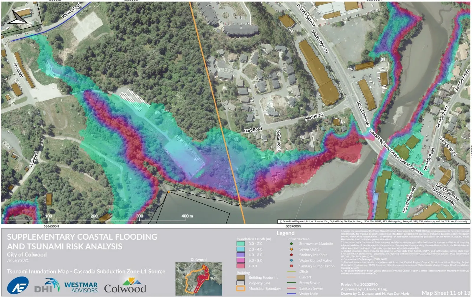
Excerpt: Heat map of potential inundation of Esqumalt Harbour at View Royal border – Millstream Estuary and Parsons Bridge
- Example: July 2016 City of Colwood Pump Station Relocation Plan RFP - example of sea level rise considerations for management of infrastructure https://www.colwood.ca/sites/default/files/RFP/RFP-2016-03%20Ocean%20Blvd%20Pump%20Station%20Relocation%20Plan.pdf