Advisory Committee/Documents/Attachment D: Table 1. Land use classification scheme and associated setback distances
Appendix
Attachment D: Table 1. Land use classification scheme and associated setback distances
April 25, 2017Page 102 sections
Regulatory setback standards from Fisheries and Oceans Canada for various land uses.
High Density Residential (50 to 80 units/ha) requires 30 metres from the High-high Water Line
Attachment D
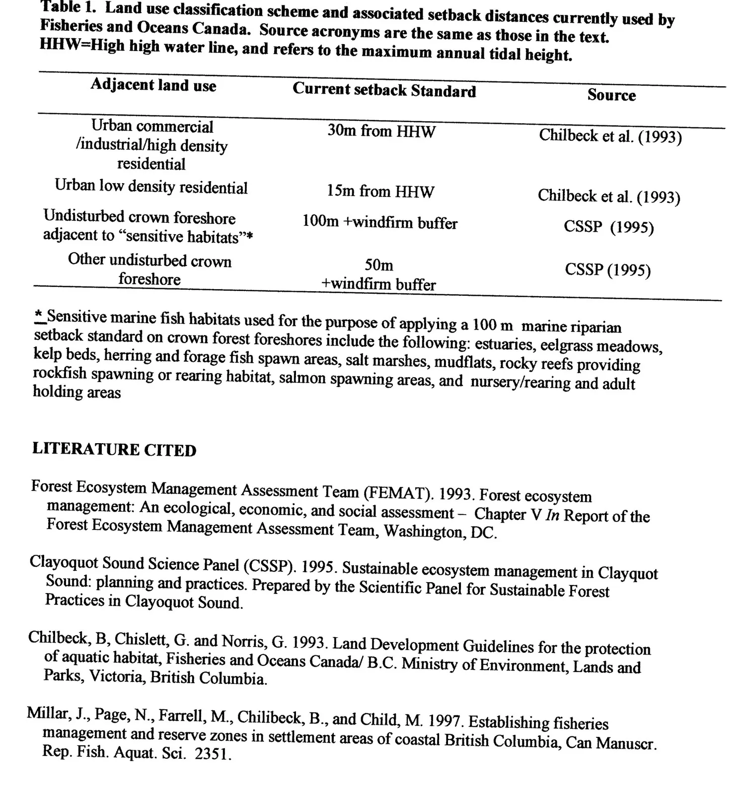
Table 1. Land use classification scheme and associated setback distances currently used by Fisheries and Oceans Canada. Source acronyms are the same as those in the text. HHW=High high water line, and refers to the maximum annual tidal height.
| Adjacent land use | Current setback Standard | Source |
|---|---|---|
| Urban commercial /industrial/high density residential *** | 30m from HHW | Chilbeck et al. (1993) |
| Urban low density residential | 15m from HHW | Chilbeck et al. (1993) |
| Undisturbed crown foreshore adjacent to "sensitive habitats"* | 100m +windfirm buffer | CSSP (1995) |
| Other undisturbed crown foreshore | 50m +windfirm buffer | CSSP (1995) |
- Sensitive marine fish habitats used for the purpose of applying a 100 m marine riparian setback standard on crown forest foreshores include the following: estuaries, eelgrass meadows, kelp beds, herring and forage fish spawn areas, salt marshes, mudflats, rocky reefs providing rockfish spawning or rearing habitat, salmon spawning areas, and nursery/rearing and adult holding areas
Page 10
LITERATURE CITED
- Forest Ecosystem Management Assessment Team (FEMAT). 1993. Forest ecosystem management: An ecological, economic, and social assessment – Chapter V In Report of the Forest Ecosystem Management Assessment Team, Washington, DC.
- Clayoquot Sound Science Panel (CSSP). 1995. Sustainable ecosystem management in Clayoquot Sound: planning and practices. Prepared by the Scientific Panel for Sustainable Forest Practices in Clayoquot Sound.
- Chilbeck, B, Chislett, G. and Norris, G. 1993. Land Development Guidelines for the protection of aquatic habitat, Fisheries and Oceans Canada/ B.C. Ministry of Environment, Lands and Parks, Victoria, British Columbia.
- Millar, J., Page, N., Farrell, M., Chilibeck, B., and Child, M. 1997. Establishing fisheries management and reserve zones in settlement areas of coastal British Columbia, Can Manuscr. Rep. Fish. Aquat. Sci. 2351.
*** NB: High Density Residential - 50 to 80 units/ha would require 30 metres from the High-high Water Line
Page 10
Extracted from: 2017 04 25 Joint Advisory Committee Meeting Agenda - Agenda - Pdf