Appendix
Attachment G: CHRISTIE POINT | LANDSCAPE MASTERPLAN
April 25, 2017Page 132 sections
The proposed landscape master plan map showing restoration zones, community gardens, and trails.
Includes view points, split-rail fences, and native vegetation restoration areas
Attachment G
Page 13
CHRISTIE POINT | LANDSCAPE MASTERPLAN
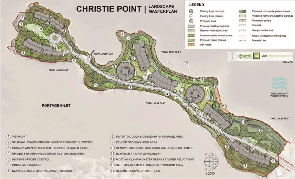
Legend
- Existing trees removed
- Existing trees retained
- Proposed trees
- Proposed building footprints
- Riparian restoration zones
- Invasive species control zones
- Proposed native grasses
- Salt marsh
- Proposed community garden spaces
- Proposed native and adaptive plantings
- Permeable pavers
- Sidewalk
- New permeable trail
- NWSA Development Permit Area
- Property Line
Map Key
- VIEWPOINT
- SPLIT-RAIL FENCES PREVENT ACCESS TO ROCKY OUTCROPS
- COMMON AMENITY AREA WITH ACCESS TO WATER VIEWS
- UPLAND & RIPARIAN VEGETATION RESTORATION AREA
- INVASIVE SPECIES CONTROL
- COMMUNITY GARDEN
- NATIVE GRASSES OVER PARKING STRUCTURE
- POTENTIAL DOCK & CANOE/KAYAK STORAGE AREA
- FENCED OFF-LEASH DOG AREA
- REMOVED INFORMAL TRAILS AND WATER ACCESS POINTS
- BIOSWALE AT EDGE OF ROADWAY
- EXISTING OLYMPIA OYSTER REEFS & OYSTER RELOCATION
- SALT MARSH & BEACH GRASS RESTORATION AREA
- RETAINED GROVE OF OAK TREES
Tidal Mud Flat Portage Inlet Predominant Winter Winds
1:2000 Dec 2-16
Page 13
Extracted from: 2017 04 25 Joint Advisory Committee Meeting Agenda - Agenda - Pdf