CRD BICYCLE WAYFINDING PILOT PROGRAM
Update on grant funding and implementation plan for regional bicycle wayfinding signage.
CRD BICYCLE WAYFINDING PILOT PROGRAM
TO: Committee of the Whole DATE: March 4, 2015 FROM: James Davison MCIP RPP, Planner MEETING DATE: March 10, 2015
RECOMMENDATION
THAT Committee receive this report for information.
CHIEF ADMINISTRATIVE OFFICER'S COMMENTS
I concur with the recommendation.
DIRECTOR OF DEVELOPMENT SERVICES' COMMENTS
I concur with the recommendation.
DIRECTOR OF ENGINEERING'S COMMENTS
I concur with the recommendation.
PURPOSE OF REPORT
To provide an update regarding the CRD Bicycle Wayfinding Pilot Program funding requirements, staff progress and desired outcomes.
BACKGROUND
On April 1, 2014 staff presented to Council a report describing the draft CRD Bicycle Wayfinding Guidelines and the potential for funding. Staff notes that at the time Council's concern was that pedestrians were not adequately addressed in the plan. Staff's discussions with the CRD reveal that the terms of the program are quite specific regarding addressing active bicycle transportation.
Since then, staff successfully applied for a grant in the amount of $8,571.00 exceeding initial estimates and removing the need for the Town to provide a partial fund of the wayfinding project. Invoices for work must be generated by March 31, 2015 to qualify for funding.
ISSUES AND ANALYSIS
Staff has $8,571.00 available in grant money to address bicycle wayfinding. Based on a rough estimate of $200 per sign (including installation costs) and the cost of ordering duplicate replacement signs, a target of 32 signs has been set for the project.
Staff is working internally and with CRD Parks in determining an appropriate sign plan. The signs will focus on wayfinding for the Galloping Goose and E&N Regional Trails, both in terms of finding the trails and navigating to destinations when on the trails (both within View Royal and to major regional destinations).
These signs are based on the TAC (Transportation Association of Canada) standard, are immediately recognizable as wayfinding signs and are designed to be easily read. Having sign templates supplied to staff in this high standard is a large benefit to the project.
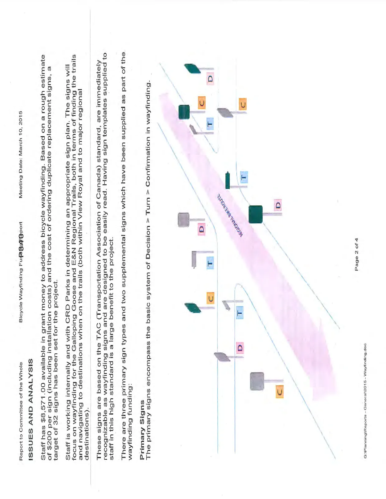
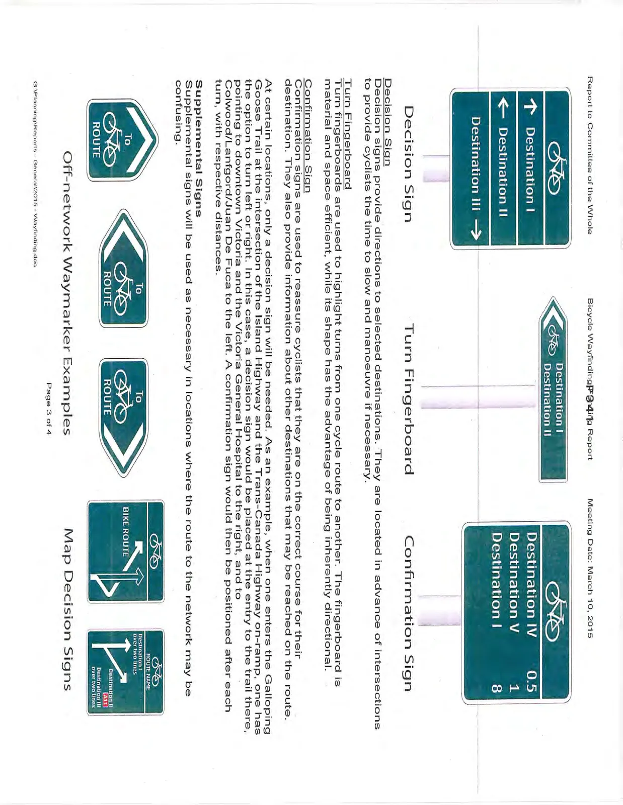
There are three primary sign types and two supplemental signs which have been supplied as part of the wayfinding funding:
Primary Signs
The primary signs encompass the basic system of Decision > Turn > Confirmation in wayfinding.
Decision Sign
Decision signs provide directions to selected destinations. They are located in advance of intersections to provide cyclists the time to slow and manoeuvre if necessary.
Turn Fingerboard
Turn fingerboards are used to highlight turns from one cycle route to another. The fingerboard is material and space efficient, while its shape has the advantage of being inherently directional.
Confirmation Sign
Confirmation signs are used to reassure cyclists that they are on the correct course for their destination. They also provide information about other destinations that may be reached on the route.
At certain locations, only a decision sign will be needed. As an example, when one enters the Galloping Goose Trail at the intersection of the Island Highway and the Trans-Canada Highway on-ramp, one has the option to turn left or right. In this case, a decision sign would be placed at the entry to the trail there, pointing to downtown Victoria and the Victoria General Hospital to the right, and to Colwood/Langford/Juan De Fuca to the left. A confirmation sign would then be positioned after each turn, with respective distances.
Supplemental Signs
Supplemental signs will be used as necessary in locations where the route to the network may be confusing.
Off-network Waymarker
Off-network waymarkers are optional signs with the specific purpose of indicating short links to designated bike routes from other streets or paths. To avoid confusing the meaning of the sign across the network, they should not be used for marking the route of designated bikeways.
Map Decision Sign
Map decision signs are unique to the circumstances they depict.
The sign templates area attached to the report.
TIMELINE
If Committee wishes, Staff can provide an update at the March 17, 2015 meeting of Council to detail the sign locations and content. The content will include identified destinations for wayfinding. Otherwise, staff will finalize the sign plan, order signs and arrange for an installation contract by the end of March to take full advantage of the funding available.
RECOMMENDATION
THAT Committee receive this report for information.
SUBMITTED BY
James Davison MCIP RPP, Planner
REVIEWED BY
Lindsay Chase, MCIP RPP, Director of Development Services
ATTACHMENTS
- Sign Templates
Document Images
(2)