Appendix
Subject Property Map and Site Plan - Lot 21
May 12, 2015Pages 135–1372 sections
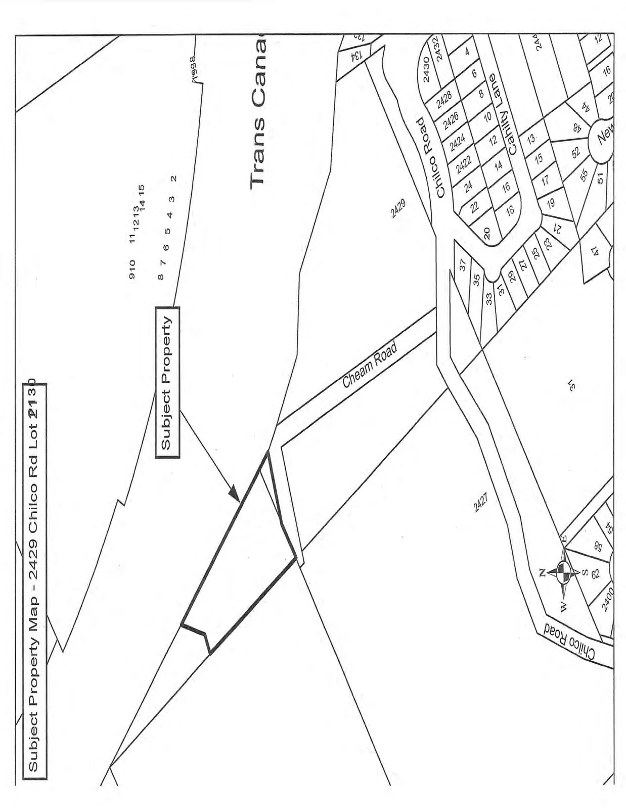
Location map and general site plan for the 6-unit North Townhomes development area.
Site area = 3952 m²
Subject Property Map - 2429 Chilco Rd Lot 2130
Page 135–137
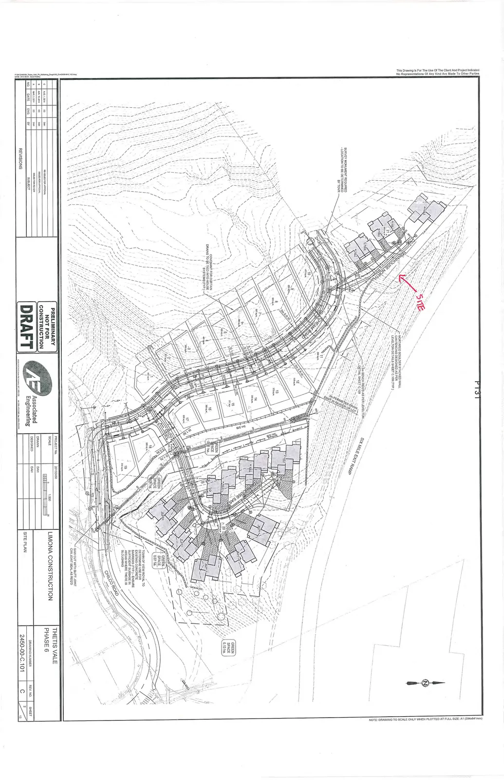
Thetis Vale Phase 6 - Site Plan
Project Information
| Project No. | Scale | Project | Subject | Drawing Number | Rev. No. |
|---|---|---|---|---|---|
| 20132450 | 1:500 | THETIS VALE PHASE 6 | SITE PLAN | 2450-00-C.101 | C |
Revision History
| No. | Date | Eng. | By | Subject |
|---|---|---|---|---|
| 0 | AUG 1, 2014 | SD | DAH | RE-ISSUED FOR APPROVAL |
| B | JUN 13, 2014 | SD | DAH | ISSUED FOR APPROVAL |
| A | MAR 3, 2014 | SD | DAH | ISSUED FOR REVIEW |
Site Plan Notes and Annotations
- SITE: Indicated by a red arrow near the northern townhouse cluster.
- Residential Areas:
- TOWNHOUSE NORTH
- TOWNHOUSE EAST
- Lots 1 through 19
- Green Spaces:
- GREEN SPACE (0.11 ha)
- GREEN SPACE (0.07 ha)
- GREEN SPACE (0.13 ha)
- Roadways:
- CHEAM ROAD
- CHILCO ROAD
- SIX MILE EXIT RAMP
- Technical and Construction Notes:
- MORTARED BOULDER STACKED WALL C/W FENCING DESIGNED AS PER LEVELTON DETAILS SHEET C.109 (TYP.)
- 1.5m BENCH REQD AS PER LEVELTON DETAIL SHEET C.109
- SURVEY MONUMENT REQUIRED - LOCATION TO BE DETERMINED BY TOVR
- COVENANT FOR CERTAIN DRAINS TO BE TIED INTO HOUSE SYSTEMS (TYP.)
- TOWN OF VIEW ROYAL TO DETERMINE USE FOR EXISTING CONCRETE BARRIERS (TYP.) - ENSURE SUFFICIENT SUBBASE IN AREAS WHERE THERE IS SLOUGHING
- SAW CUT WITH BUTT JOINT C/W JOINT SEAL AS REQ'D
THIS PAGE INTENTIONALLY LEFT BLANK
Page 135–137
Document Images
(1)
Extracted from: 2015 05 12 Committee of the Whole Agenda