Appendix
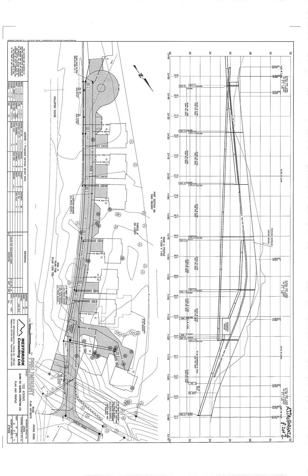
PROPOSED SUBDIVISION OF LOT 6... 102 ATKINS (Plan and Profile)
September 8, 2015Page 791 section
Engineering profile of the proposed internal road 'Road A'.
June 2015
102 ATKINS ROAD
PLAN AND PROFILE
Project Information
- Client: ENVIRO TEC GENERAL CONTRACTING LTD.
- Project No: 2794
- Drawing No: 2794
- Sheet: 2 OF 2
- Date: JUNE 2015
- Scale: H 1:250 V 1:50
- Consultant: Westbrook Consulting Ltd., #110 - 585 Goldstream Ave., Victoria, BC V9B 2W4 (Tel: 250-391-8593)
Legend - Proposed services shown bold
| Symbol | Proposed | Existing | Description | Symbol | Proposed | Existing | Description |
|---|---|---|---|---|---|---|---|
| SD | SD | SD | STORM SEWER | RS | RS | — | ROAD SIGN |
| SS | SS | SS | SANITARY SEWER | RED | RED | — | REDUCER |
| W | W | W | WATER | LP | — | LP | LIGHT POLE |
| IC | IC | — | INSPECTION CHAMBER | PP | — | PP | POWER POLE |
| MH | MH | MH | MANHOLE | AN | — | AN | ANCHOR |
| CB | CB | CB | CATCH BASIN | TR | — | TR | TREE |
| HYD | HYD | — | HYDRANT | LOT PIN | — | [Square Symbol] | LOT PIN |
| GV | GV | — | GATE VALVE | LEAD PLUG | — | [Cross Symbol] | LEAD PLUG |
| CO | CO | — | CLEANOUT | EL | — | EL | HYDRO / TEL / GAS |
| RL | RL | — | ROAD LAMP |
Profile Data (ROAD A)
- Vertical Curves:
- 10.776m VERT. CURVE, PVI STA = 0+81.11, PVI ELEV = 23.853
- 30.000m VERT. CURVE, PVI STA = 1+48.33, PVI ELEV = 26.830
- 8.000m VERT. CURVE, PVI STA = 2+53.60, PVI ELEV = 24.803
- Grades: 2.00%, 0.75%, 2.00%, 4.41%
- Key Infrastructure Labels: SDO 5, SDO 4, SDO 3, SDO 2, SDO 1, SMH 4, SMH 3, SMH 2, CB 6, CB 7, FIELD INLET.
Plan Notes and Labels
- Property and Boundary Labels:
- PART SECTION 98 E&N RAILWAY
- PARCEL A DD L2563
- REM. 6 PLAN 748 (PLAN 1205 OS)
- GALLOPING GOOSE
- CHILCO ROAD
- ATKINS ROAD
- Construction Notes:
- EXISTING BUILDINGS TO BE REMOVED.
- FLUSH VALVE AS PER EXD. STD. DWG. 5.9.
- 1'-0"X3'X3' CONC. THRUST BLOCKS.
- 11 1/4° BEND (100x100) C/W "DENSO" WRAP & 1'-0"X1'-0"X1'-0" C.W. THRUST BLOCKS.
- TO BE DETERMINED IN FIELD.
- FIELD INLET 100mm PVC INV. = 22.80.
- RETAINING WALL AS REQUIRED.
- General Disclaimer: The location and elevation of all existing utilities must be verified on site before construction commences. For complete and actual horizontal or vertical offsets, contact the appropriate utility companies. The contractor is responsible to confirm the depth of each connection to the main at any point to the satisfaction of the engineer.
Revisions
| No. | Description | Date |
|---|---|---|
| 1 | ISSUED FOR DEVELOPMENT PERMIT | 2015-07-02 |
Page 79
Extracted from: 2015 09 08 Committee of the Whole Agenda