Development Variance Permit No. 2014/05 – Glenairlie Drive
Report on a request to increase maximum fence height to 2.5m for 12 lots bordering the E&N Rail Trail.
TOWN OF VIEW ROYAL PLANNING & DEVELOPMENT REPORT
TO: Committee of the Whole DATE: January 7, 2015 FROM: Jeff Chow, MCIP RPP, Senior Planner MEETING DATE: January 13, 2015 FILE NO.: 3090-20-2014/05
DEVELOPMENT VARIANCE PERMIT 2014/05 – 305/309/313/317/319/325/329/333/337/341/345/349 Glenairlie Drive
RECOMMENDATION
THAT the Committee of the Whole receive the January 6, 2015 report from the Senior Planner titled "Development Variance Permit 2014/05 – 305/309/313/317/319/325/329/333/337/341/345/349 Glenairlie Drive" for information.
CHIEF ADMINISTRATIVE OFFICER'S COMMENTS
I concur with the recommendation.
DIRECTOR OF DEVELOPMENT SERVICES' COMMENTS
I concur with the recommendation.
PURPOSE OF REPORT
To present an application for a Development Variance Permit to permit a maximum fence height of 2.5m along the rear property line where 2.0m is the maximum permitted.
BACKGROUND
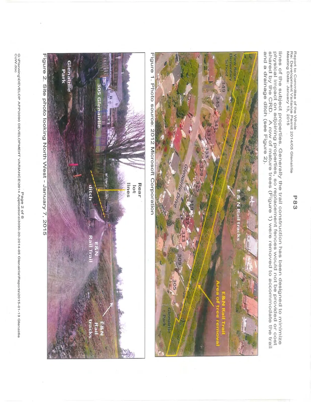
The subject properties are comprised of 12 single family residential lots that border the E&N Rail corridor (see Attachment 1).
Construction of Phase 2 of the E&N Rail Trail between Four Mile Bridge and the Island Highway / Burnside Road West intersection began in the summer of 2014. The trail is being built by the Capital Regional District within the E&N rail right-of-way between the rail line and the rear lot lines of the subject properties. Generally the trail construction has been designed to minimize physical impact on adjoining properties, so replacement fences would not be provided or cost shared by the CRD. A row of mature trees (Figure 1) were removed to accommodate the trail and a drainage ditch (see Figure 2).
Following the removal of nearly all the trees buffering the subject properties from the E&N corridor, a delegation of the subject property owners presented a request to permit increased fence heights at the October 7, 2014 Council meeting. Council passed a motion that the property owners submit a development variance permit application (Attachment 2). In the meantime, staff is working with CRD and homeowners to mitigate screening impacts within the scope of the Tree Protection Bylaw No. 695, 2009.
Other properties on Glenairlie Drive that border the E&N Rail right-of-way are not included in this proposal because they are elevated above the level of the railway tracks and the new trail.
PROPOSAL
The applicant requests a Development Variance Permit to permit a maximum fence height of 2.5m (2.0m maximum permitted) along the rear property line of 12 single family residential properties that border the E&N Rail Trail.
ANALYSIS
A high privacy fence adjacent to a trail is typically not encouraged because the blank wall effect would create an unfriendly pedestrian streetscape and could compromise the safety of trail users through the loss of oversight. In this case there are several reasons in support of the requested variance in this location:
- The railway tracks are higher than the elevation of the subject properties
- There is no space to plant replacement trees within the right-of-way
- No adjacent properties would be affected.
The following should also be noted:
a. If the permit is approved, individual owners of the subject properties are not obliged to construct a new fence, so there may be variations in fence heights. b. If the permit is approved and a property owner does not substantially construct a fence by the time the permit expires (24 months), any fence must comply with applicable Zoning Bylaw requirements. A new development variance permit application can be submitted. c. Section 5.6.1 of Property Maintenance Bylaw No. 512, 2003 requires property owners to remove graffiti.
No specific design is proposed, which is acceptable given the number of individual properties and the context adjacent to the trail.
If no significant issues arise at the Committee of the Whole meeting, staff can carry out notification of the Council meeting to consider this application as per the requirements of the Local Government Act and Development Procedures Bylaw No. 730, 2009.
RECOMMENDATION
THAT the Committee of the Whole receive the January 6, 2015 report from the Senior Planner titled "Development Variance Permit 2014/05 – 305/309/313/317/319/325/329/333/337/341/345/349 Glenairlie Drive" for information.
SUBMITTED BY: J. Chow MCIP RPP, Senior Planner
REVIEWED BY: L. Chase MCIP RPP, Director of Development Services
ATTACHMENTS:
- Subject Property Map
- Oct. 7, 2014 Council Minutes excerpt
Document Images
(3)