Appendix
Site Plan - Prince Robert Ridge
April 10, 2012Page 1082 sections
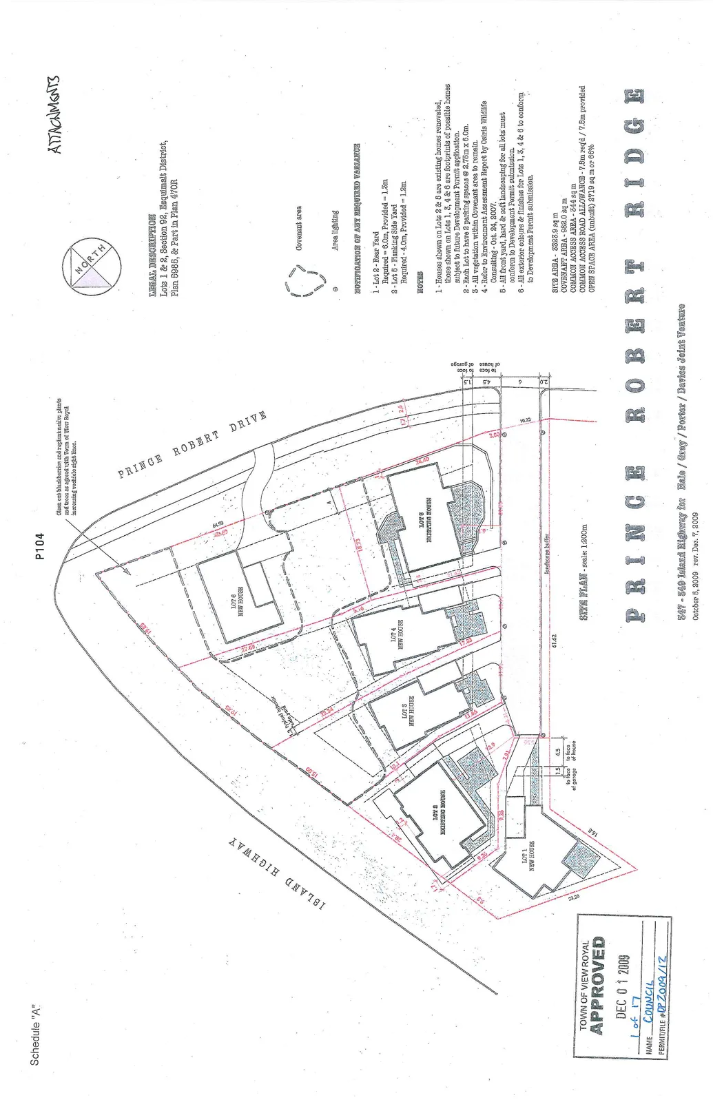
Detailed site plan showing footprint of new and existing homes.
3323.9 sq m site areaDecember 7, 2009
Page 108
PRINCE ROBERT RIDGE
547 - 549 Island Highway for Hale / Gray / Porter / Davies Joint Venture October 5, 2009 rev. Dec. 7, 2009
LEGAL DESCRIPTION
Lots 1 & 2, Section 92, Esquimalt District, Plan 5986, & Part in Plan 470R
NOTIFICATION OF ANY REQUIRED VARIANCE
- Lot 2 - Rear Yard Required = 8.0m, Provided = 1.3m
- Lot 6 - Flanking Side Yard Required = 4.0m, Provided = 1.3m
NOTES
- Houses shown on Lots 2 & 5 are existing homes renovated, those shown on Lots 1, 3, 4 & 6 are footprints of possible homes subject to future Development Permit application.
- Each Lot to have 2 parking spaces @ 2.75m x 6.0m.
- All vegetation within Covenant area to remain.
- Refer to Environment Assessment Report by Osiris Wildlife Consulting - Oct. 24, 2007.
- All front yard, hard & soft landscaping for all lots must conform to Development Permit submission.
- All exterior colours & finishes for Lots 1, 3, 4 & 6 to conform to Development Permit submission.
SITE AREA
- SITE AREA - 3323.9 sq m
- COVENANT AREA - 952.0 sq m
- COMMON ACCESS AREA - 344 sq m
- COMMON ACCESS ROAD ALLOWANCE - 7.5m req'd / 7.5m provided
- OPEN SPACE AREA (unbuilt) - 2719 sq m or 66%
SITE PLAN - scale: 1:200m
Site Plan Annotations:
- Clean out blackberries and replant native plants and trees as agreed with Town of View Royal increasing vehicle sight lines.
- Legend:
- Covenant area (indicated by dashed line)
- Area lighting (indicated by circle symbol)
- Lot Labels:
- Lot 1: New House
- Lot 2: Existing House
- Lot 3: New House
- Lot 4: New House
- Lot 5: Existing House
- Lot 6: New House
Page 108
Extracted from: 2012 04 10 Committee of the Whole Agenda