Staff Report: ENVIRONMENTAL DEVELOPMENT PERMIT WITH VARIANCES - 265 View Royal Avenue
A report regarding a development permit application for a house and accessory building at 265 View Royal Avenue, requiring several variances.
TOWN OF VIEW ROYAL
COMMITTEE OF THE WHOLE REPORT
TO: Committee of the Whole DATE: July 5, 2017 FROM: J. Chow, Senior Planner MEETING DATE: July 11, 2017 FILE NO.: 3060-20-2017/02
ENVIRONMENTAL DEVELOPMENT PERMIT WITH VARIANCES - 265 View Royal Avenue
RECOMMENDATION
THAT the July 5, 2017 report from the Senior Planner titled “Environmental Development Permit With Variances - 265 View Royal Avenue” be received.
CHIEF ADMINISTRATIVE OFFICER’S COMMENTS
I concur with the recommendation.
DIRECTOR OF DEVELOPMENT SERVICES’ COMMENTS
I concur with the recommendation.
PURPOSE OF REPORT
To present an Environmental Development Permit application with variances for the construction of a house and accessory building and to permit works within the Natural Watercourse and Shoreline Environmental Development Permit area. Variances are requested for the length or width of an accessory building, the siting of an accessory building to be located within the front yard, lot coverage of an accessory building, and total building floor area.
BACKGROUND
The approximately 1974m² property is zoned R-1: Detached Residential (Large Lot) and backs on to Esquimalt Harbour. Development Permit 2010/21 was approved by Council on December 7, 2010 to permit the construction of a house with variances to allow the siting of an accessory garage in the front yard, increased length/width of an accessory building, and increased fence height. The property has been vacant since a pre-existing dwelling and cottage were removed in 2010 and a foundation was partially constructed.
In 2006 a number of structures were built without permits. The structures that were permitted to remain include wood stairs at the rear of the property leading to a set of concrete steps below the seawall, and a landscape tie retaining wall that stabilizes the slope against the stairs. These wooden structures have weathered and now need replacement.
PROJECT INFORMATION
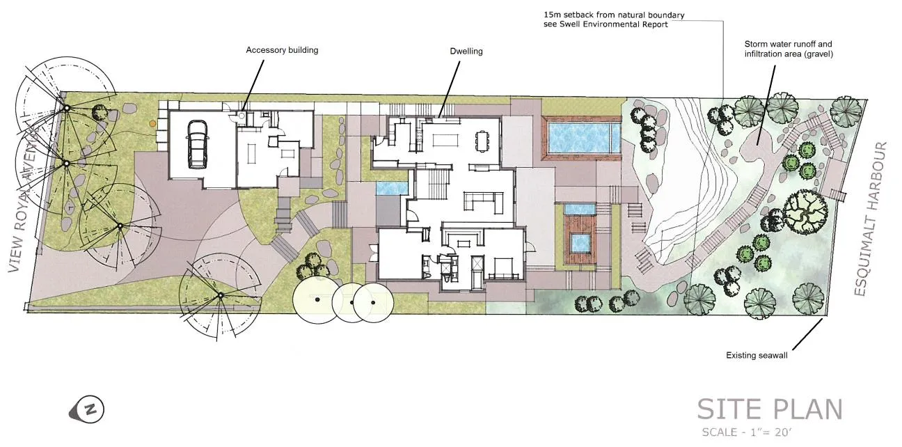
The new property owner proposes to construct a 369 m² detached dwelling with a 123m² garage/office accessory building in the front yard as shown in Figure 1 and Attachment 4. Some trees within the building envelope would be removed to accommodate the development. The applicant has provided letters of support from several neighbours.
The development permit area covers land within 15m of the natural boundary. This part of the property is steep and primarily vegetated with invasive species. Within this area, the applicant proposes the following:
- Replacement of existing retaining wall, walkway and stairs with a wider landing near the seawall
- 5m² surface runoff collection and infiltration area that can also be used for seating
- Placement of boulders to stabilize soils, as needed
- Removal of non-native, invasive species
- Planting of native species
Variances are also requested for the following:
| Description | Required | Proposed |
|---|---|---|
| Length or width of an accessory building | 7.5m | 15.9 m |
| Siting of an accessory building | Not within the front yard | Within the front yard |
| Lot coverage of an accessory building | 60m² | 123m² |
| Total building floor area | 372m² | 438 m² |
The applicant has submitted the following information in support of their application:
- Applicant’s Statement
- Neighbourhood Plan Review Petition
- Renderings – Christopher Developments
- Biologist’s Report – Swell Environmental Consulting Ltd
- Review of Proposed Drainage Plan – MGE Services
ISSUES AND ANALYSIS:
The key issues are:
- How does the proposal address the development permit area guidelines?
- Are the requested variances supportable?
- Next steps to Council consideration
1. Development Permit Area Guidelines
The proposal meets the objectives of the guidelines and can be supported for the following reasons:
a. Development of the shoreline area is minimal – the storm water detention and infiltration area (see Figure 1) is located on the previous cottage site and the drainage pipes would located under the walkway and stairs to minimize ground disturbance.
b. Construction of the 5m² storm water detention and infiltration area would be mitigated by restoring 10m² within the leave strip through removal invasive species and replanting as specified in the biologists report (Attachment 5) for a net increase in native vegetation.
c. Areas to be disturbed in rebuilding the stairs and retaining wall are primarily vegetated with invasive plant species and would be replanted with native species.
d. The storm water that will be channelled towards the sea will have high velocity from running down the steep slope and a splash pad or other device will be required to meet servicing standards at the building permit stage to prevent scouring of the beach.
e. The biologist’s report (Attachment 5) recommends best management practices for timing, erosion and sediment control measures, machinery leak and spill prevention, marking off native plant areas during construction, and monitoring that would be incorporated into the development permit conditions.
2. Requested variances
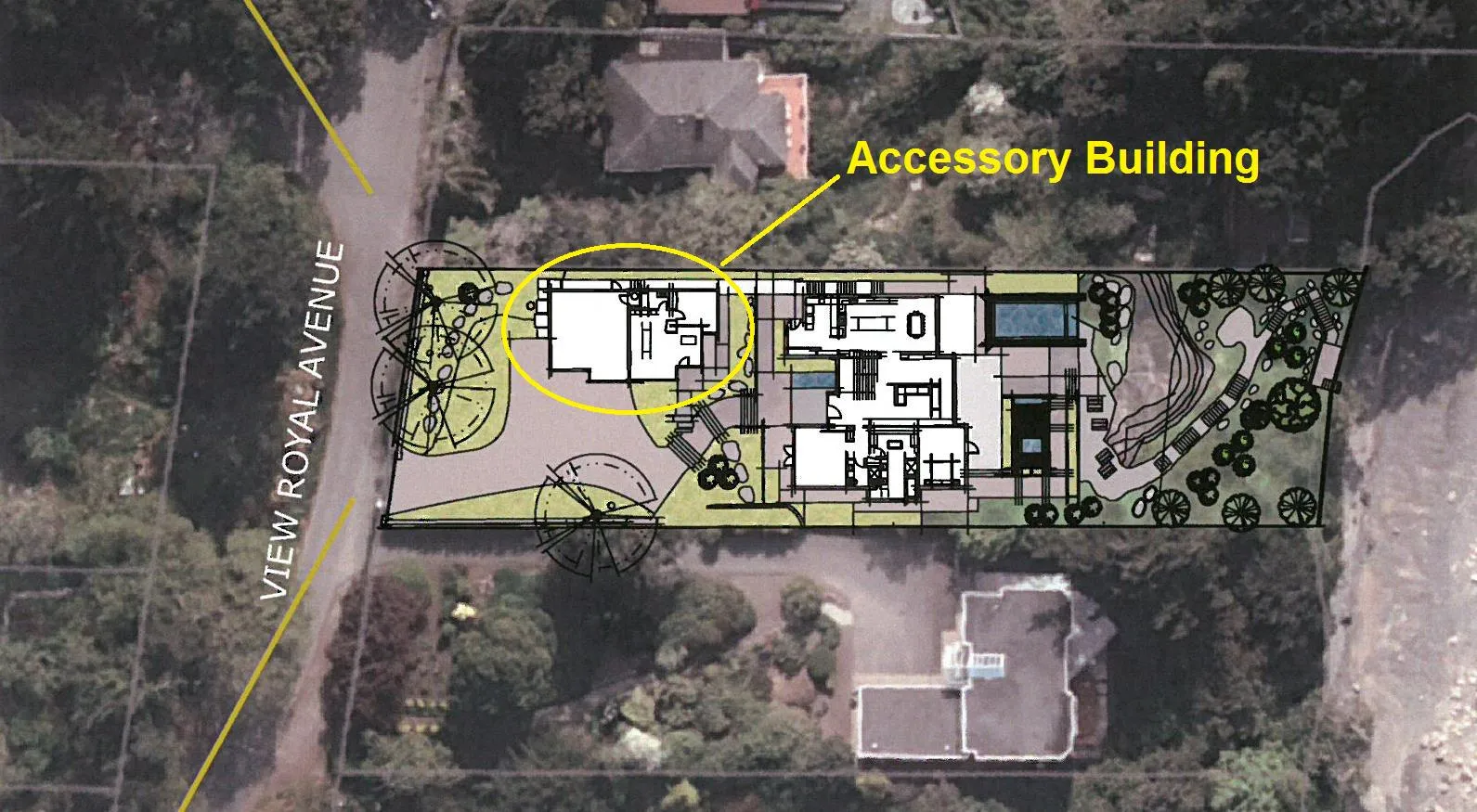
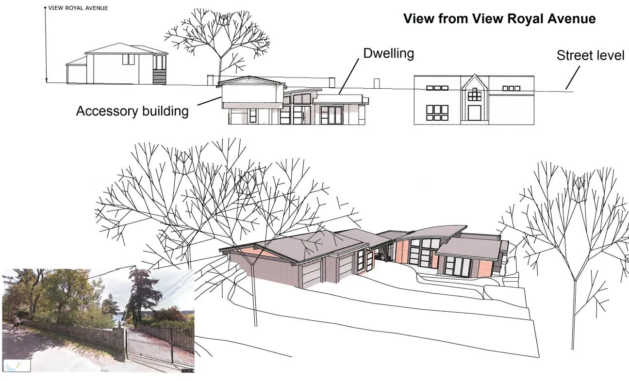
a. Length or width of an accessory building The request to vary the length or with of an accessory building from 7.5m 15.9 m can be supported because the lot is large and the building would not have a visual impact from the street and adjacent properties as shown in Figure 2.
b. Siting of an accessory building The property is narrow and deep with the dwelling proposed to be located in the middle of the lot as shown in Figure 1. The accessory building is proposed to be 12 metres from the front lot, which exceeds the minimum setback for 7.5m for a dwelling. The site also slopes as shown in Figure 3. The proposal can be supported because the accessory building would not be visually obtrusive.
c. Lot coverage of an accessory building The proposed lot coverage is 123m² where the Zoning Bylaw requires 10% maximum lot coverage, up to 60m². The proposal to increase the 60m² cap can be supported because the 6% lot coverage would be small relative to the size of the lot.
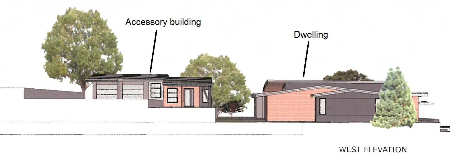
d. Total building floor area The R-1 Zone permits Floor Space Ratio of 0.42:1 with building floor area capped at 372m². The proposed building floor area of 438m² is comprised of the 369m² dwelling and the 69m² accessory building (garage area is excluded). The variance to increase the building floor area cap be supported because the Floor Space Ratio is only 0.24:1; i.e. the building floor area is small relative the size of the lot. Also, the proposed site layout is not visually obtrusive: the dwelling is set into the slope so that it one storey facing the street and two storeys at the rear. The rooftop of the dwelling would actually be below street level as shown in Figure 4.
3. Next steps
The variance notification has been mailed to residents and the application will come forward to Council for consideration July 18, 2017.
RECOMMENDATION
THAT the July 5, 2017 report from the Senior Planner titled “Environmental Development Permit With Variances - 265 View Royal Avenue” be received.
SUBMITTED BY: Jeff Chow, MCIP RPP, Senior Planner
Document Images
(3)