Price Shoreline Access Report
Assessment and recommendations for the Price shoreline access point.
Price Shoreline Access
General
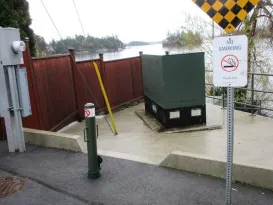
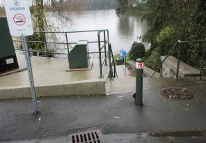
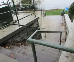
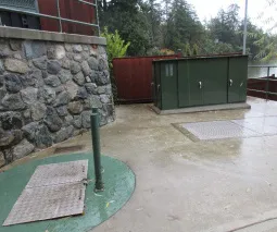
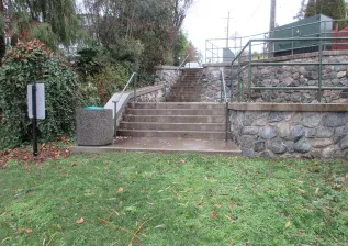
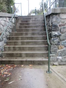
Price Shoreline Access is an unidentified (no signage) water access to Price Bay at the south end of Price Road. TOVR pump station equipment is located on the upper level and a secondary terrace (both hardscaped). Access to the shoreline is via a substantial 17 riser/1 landing concrete staircase on the west side. The vertical drop from top to bottom of the staircase is approximately 2.9m. The upper level, secondary terrace and stair/retaining walls are stone-faced and are topped with green painted metal guardrails for safety. Neither the secondary terrace nor the shoreline is universally accessible. A garbage receptacle and Tsunami warning sign are located at the bottom of the staircase. The staircase is slightly wider at the top than bottom, with width ranging from approximately 2m to 1.6m.The horizontal distance between the concrete stairs/lower retaining wall and top of bank (HWM) is approximately 6m.
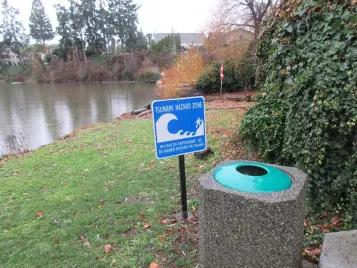
The shore is in a Tsunami danger area and a warning sign is posted.
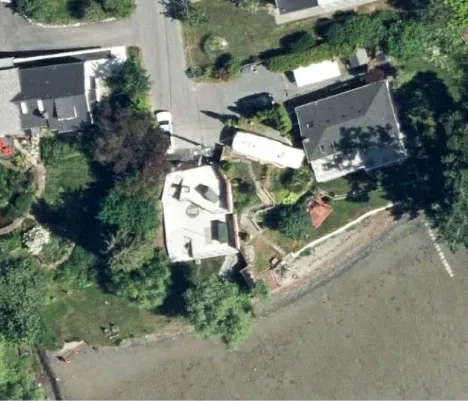
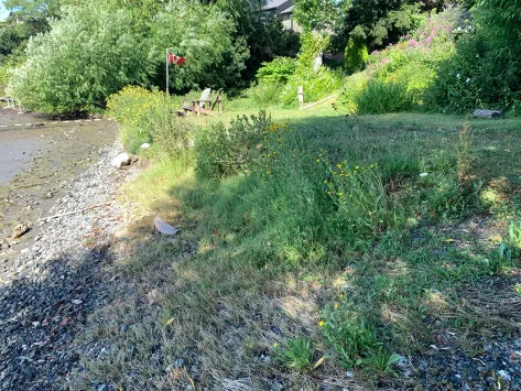
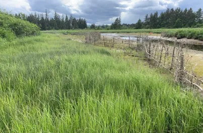
The beach is gently sloped towards the water and includes a patchy, weedy, grass lawn with a saltmarsh fringe along the water; the salt marsh includes seashore saltgrass, sea asparagus, entire leaved gumweed, silverweed, and orache. See photo below.
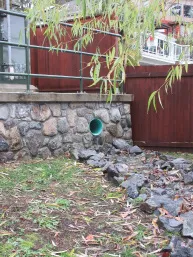
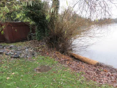
A constructed rock channel that directs drainage from a discharge pipe in the lower retaining wall to Price Bay is located on the east side. The neighbour’s 1.8m ht. solid wood panel fence defines the full extent of the east property line (see photo page 17). The upper west property line is defined by the staircase but undefined between the stair and water’s edge. Common snowberry mixed with invasive species is growing on the west side, adjacent the stair.
There is an English ivy-covered willow tree, (potentially non-native Golden Willow or native Pacific willow) and poplar tree at the water’s edge, east side.
During the highest tides of the year, the grass shoreline (Crown land) is flooded up to the garbage can. As can be seen in the photo on page 17, neighbours to the west are using the foreshore as private property, and there is no separation between the TOVR water access and that portion of foreshore. Neighbours to the east have built a fence on Crown land to create privacy, and are also using the foreshore as private property.
The CRD tested the water at Price Shoreline for quality and sediments in 2011. No concerns were noted. In 2012 the CRD tested the water at the property immediately west of Price Shoreline Access and found it to be of good quality; in 2012 the CRD found moderate levels of sediments. It is due to be resampled in 2022.
Challenges
- The upper pump station pad is tight to Price Road leaving no opportunity for planting at road level, or for seating off the pad, and the staircase does not support universal access. On the water side, the shoreline is in a Tsunami danger area and floods during high tides several times a year.
- The south end of the west property line is unknown, and the area around the bottom of the stair on the west side is full of English ivy.
- TOVR does not support the use of raised planters due to maintenance issues.
Price Road is a very narrow road with little to no parking opportunities; two ‘no parking’ signs are posted at the road end to ensure access to neighbouring properties is maintained.
The shore is in a Tsunami danger area.
Geese enjoy this foreshore!
Opportunities and Recommendations
- Install a sign identifying this public shore access.
- Install decorative wrap on the pump station/kiosks.
- Apply an anti-graffiti coating on all exposed retaining walls.
- To provide a viewing opportunity and respite for someone who can’t get down the stairs, install a bench on the upper concrete pad parallel to and adjacent the curb. Ensure there is adequate circulation space to get to the bench and that bench is oriented for best view. (see marked-up photos page 19)
- Provide a second viewing opportunity on the lower concrete pad parallel to and near the railing, allowing for adequate circulation to and around the bench. Orient bench for best view. (see marked-up photos page 20)
- Relocate garbage can from foreshore to street level, tight to west property line.
- Following ‘Green Shores’ principles and guidelines for shoreline restoration is recommended. https://stewardshipcentrebc.ca/green-shores-home/
- As part of the restoration maintain willow for aesthetic purposes (even if non-native) and fully remove English ivy from it. Also retain native poplar and fully remove English ivy from it.
- Surveying (or approximating) the west property line, and fully removing all invasive species on TOVR land, is recommended. Work with west neighbour (lot #9) to encourage removal of invasive species on their property as well, and to cooperatively manage geese on the foreshore (more on geese management below). To deter the public from using the foreshore immediately adjacent lot #9, identify the limit of the public access with appropriate native species plantings on the foreshore.
- In addition to following ‘Green Shores’ guidelines, incorporate a shoreline habitat design that will deter geese by reducing food sources, preferred nesting and brood-rearing areas, and increase the sense of insecurity from predators. The main actions are:
- Stop public from feeding the geese (signage)
- Reduce total amount of lawn area and the amount of young shoots geese prefer within lawns
- Plant trees and taller shrubs to interfere with flight lines and limit access to open water
- Create dense shoreline shrub plantings of various heights to discourage nesting and to create a barrier between the land and water
- Install temporary protective fencing while vegetation becomes established. See photo below for example of natural willow fencing by Guardians of Mid-Island Estuaries
- Determine where archaeological sites are, if any, on Price Shore water access, and acknowledge them in accordance with the wishes of the local First Nations.
- Extend planting at bottom of stairs to create visual cue regarding limit of TOVR maintained shoreline access. See photo on page 20. Recommended plant selection is on page 21.

Shrubs & Ferns Suitable for Defining West Limit of Public Access at Beach
| Common Name | Botanical Name | Notes |
|---|---|---|
| Baldhip Rose aka Woods Rose | Rosa gymnocarpa | 0.5 -2m tall, full sun to shade, pink flowers followed by small red hips, soft weak prickles on stems, spreading, drought and salt spray tolerant, deciduous |
| Evergreen Huckleberry | Vaccinium ovatum | 1-2m tall in sun / 4m+ in shade, sun or shade, slow grower, pinkish white flowers followed by edible blue-black berries, drought tolerant, salt spray and wind tolerant, evergreen |
| Oceanspray | Holodiscus discolor | 1-3m tall, flowers turn brown & persist over winter, saltwater/sea spray tolerant, deciduous |
| Red-flowering Currant | Ribes sanguineum | 1-3m tall, deciduous, sun to light shade |
| Saskatoon Berry | Amelanchier alnifolia | To 1.5m tall, deciduous, not shade tolerant |
| Snowberry | Symphoricarpos albus | 0.5-2m tall, saltwater/sea spray tolerant, light shade, deciduous |
| Sword Fern | Polystichum munitum | To 1.5m tall, saltwater/sea spray tolerant, sun to part shade, evergreen |