DEVELOPMENT OF ROAD ENDS BACKGROUND REPORT
A background report detailing the history, vision, and implementation of the Road Ends Project (C-114) from 2009 to 2023.
TOWN OF VIEW ROYAL PARKS & RECREATION REPORT
TO: Committee of the Whole DATE: March 8, 2023 FROM: Ivan Leung, P.Eng, Director of Engineering MEETING DATE: March 14, 2023
DEVELOPMENT OF ROAD ENDS BACKGROUND REPORT
RECOMMENDATION:
THAT the report titled “Development of Road ends Background Report” be received for information.
PURPOSE:
The purpose of this report is to provide the Committee with a ‘road map’ to how the Development of Road Ends Project was created (C-114). This information may be beneficial to the Committee as part of their discussions regarding a requested postponement of this project.
SUMMARY:
The timeline from project idea to program vision, followed by program approval and implementation, are summarized as follows:
Project Idea – Crane Place and Other Potential Accesses (2009-2017)
The idea for utilizing road ends for public use was initially requested at the September 22, 2009 PREAC meeting, where the motion was carried:
THAT the Committee recommends to Council that staff be directed to review areas of undeveloped lands throughout View Royal, starting with Crane Access, for the possibility of public recreational use.
Staff subsequently reviewed these opportunities, starting with Crane Place. What resulted were discussions spanning until 2017 when it was decided to incorporate the findings in the holistically based Parks Master Plan.
After the September 22, 2009 PREAC meeting and up until the adoptions of the Parks Master Plan in 2017, records indicate the following resolutions and discussion items with respect to Crane Place and other road ends:
| Meeting Type | Date | Resolution / Discussion |
|---|---|---|
| PREAC | Apr. 7, 2010 | PREAC identified the Crane Place access as one of ten priorities for implementation from the Town’s Parks Master Plan of the day |
| Budget | 2010 | As a result of the April 7 PREAC meeting, Council approved a $25,000 budget for improvements to the Crane Place road allowance |
| Council | Jul. 6, 2010 | Council carried three readings to the road closure bylaw on Crane Place to remove the highway dedication necessary to install a path access to the shore area |
| Council | Nov. 16, 2010 | After the public voiced concerns regarding the Crane Place access, Council tabled the road closure bylaw until staff review alternative options for creating a park in this area, and to conduct further discussions with the neighbouring property owners |
| PREAC | Nov. 23, 2010 | PREAC discussed with staff alternative options for creating a park in the Crane Place area, and it was mentioned that Town Council was in discussions with the property owners regarding the access concerns |
| PREAC | Sept. 24, 2013 | PREAC was informed that the development of a Crane Place right-of-way park would not be proceeding at this time |
| PREAC | Mar. 24, 2015 | PREAC discussed a number of water accesses in View Royal (Polly Place, Parkcrest Drive, Crane Place, Stillwater Road). PREAC carried a motion recommending to Council that staff be directed to mark the #49 Polly Place water access, off of Kingham Place, with signage and marking posts delineating the right-of-way |
| Committee of the Whole | Jul. 21, 2015 | It was carried that two foreshore accesses (Crane Place and Tidewater Road) be considered as priority for infrastructure preservation; and that staff be authorized to proceed to contact neighbours adjacent to Crane Place and Tidewater Road to determine the configuration and costs to establish infrastructure access |
| PREAC | Nov. 24, 2015 | PREAC investigated possible future public accesses and carried that the Committee recommend that Council consider linear park connections between Duffus Trail, Parsons Road and Kelvin Grove Park in the Parks Master Plan |
| PREAC | Nov. 24, 2015 | PREAC also discussed the concept for the Inter-Municipal Marine Trail that runs through five municipalities. PREAC carried a motion supporting the dock installation at the Shoreline Drive water access |
| PREAC | Sept. 27, 2016 | PREAC was updated on the Parks Master Plan which included discussions and findings on water access opportunities |
| PREAC | Oct. 20, 2016 | PREAC special meeting (engagement workshop) relating to the Parks Master Plan (and water accesses as a result) |
| PREAC | Mar. 28, 2017 | PREAC and staff discussed water accesses which would be addressed as part of the ongoing Parks Master Plan project. The priority locations of these water accesses would be based on best community benefit while also balancing funding to ensure that the environmental issues could be addressed |
| Committee of the Whole | Apr. 11, 2017 | The Parks Master Plan was brought forward to the Committee. Regarding the road ends, the sites were generally described to be quiet contemplative spaces primarily intended for local use |
| Council | Jun. 20, 2017 | The Parks Master Plan was adopted by Council |
Table 1: Water Access Discussions (2009-2017)
Project Vision – Parks Master Plan (June 2017)
The Parks Master Plan was shaped by community consultation and guided by the Official Community Plan and Council’s Strategic Plan. The purpose of the Master Plan is to inform on short and mid term actions to the Town’s parks to ensure that these actions align with the values of the Official Community Plan and Strategic Plan.
The Master Plan identifies road ends or “shoreline accesses” as a type of park in View Royal. Section 6.0 of the Master Plan outlines the goal of connecting people to water by:
- Developing a range of waterfront road end opportunities including viewpoints, launch sites for non-motorized boats, and public access to the waterfront
- Balance the use of the waterfront with the protection of environmentally sensitive areas
These are further identified as mid term / ongoing priorities for the Town (Strategy 17 and Strategy 18 of the Action Plan). Strategy 17 prioritized a list of road ends to improve as follows:
- Crane Place
- Beaumont Road
- Polly Place
- Thomas Park Road
- Stillwater Road
- Heddle Road
- Dukrill Road
- Midwood Road
- Price Road
Per Table 1 above, the Parks Master Plan was adopted at the June 20, 2017 regular council meeting.
¹ Town of View Royal, Vancouver Island University, 2017, Town of View Royal Parks Master Plan (June 2017), accessed March 8, 2023, https://www.viewroyal.ca/assets/Town~Hall/Documents-Forms/Parks/TVR%20Parks%20Master%20Plan%20Final%203.pdf
Project Approval – Development of Road Ends Project N-12 (2019)
The original Development of Road Ends project was presented and subsequently approved by Council as part of the 2019 budget deliberations. The project laid the foundation for road ends improvements for the next five years, with the priority road ends matching those identified in the Parks Master Plan. The associated cost estimate ($40,000 per road end) was also drawn from the Parks Master Plan. Approximately 22% of the capital budget is funded through DCC’s, the remainder by Casino revenue.
Project #1 – Beaumont Road Access Improvements
This road end project was approved in the 2019-2023 Financial Plan (C-41). The project was brought forward in 2019 to align with the drainage improvements in the same area, thus mitigating disturbance to the public and the environment. The project commenced in late 2019 and was completed in 2020.
The road end improvement works included landscaping, picnic tables and garbage cans, and an upgraded concrete pathway complete with stairs and railings leading to the shore.
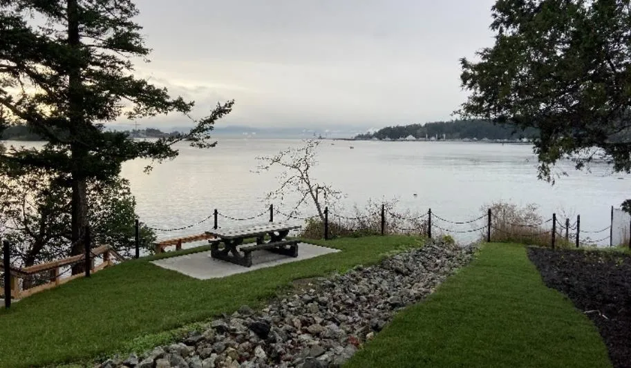
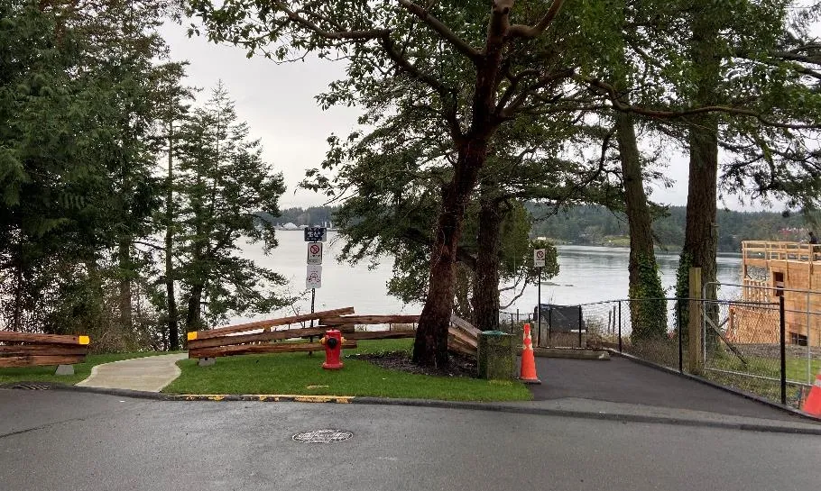
Figure 1: Beaumont Improvements
Project #2 – Crane Place Access Improvements
This road end project was approved in the 2021-2025 Financial Plan (N-12). Crane Place was supposed to be the first project in the program but was subsequently delayed to 2021 due to the COVID pandemic.
The improvements were very minor in nature after consultations with the neighbouring properties. The works included a small mulch path towards a small viewing area at the shore, complete with garbage can. The works also provide an important element of access to the Town’s assets, as this path is only one of a few important access points to the sanitary sewer system that serves many properties on Kingham Place.
Project #3 – Road Ends Design Guidelines
Following the Beaumont Road and Crane Place Access Improvements, staff retained a Landscape Architect and Registered Professional Biologist to complete design guidelines for the remaining road end improvements. This was generally done to alleviate staff workload, as these professionals could provide informed and catered designs for staff to follow, given the uniqueness of each site. They also provided guidance on the more challenging sites such as the Polly Place road end.
The design guidelines for the remaining road ends were completed in late 2022.
Project #4 – Polly Place Access Improvements
The Polly Place road end initially commenced in 2015 through a motion at the March 24, 2015 PREAC meeting (per Table 1).
Staff subsequently conducted a neighbourhood survey regarding a potential water access at this location. The survey identified significant resident opposition at that time.
The road end opportunity was reinitialized as a result of the 2017 Parks Master Plan, followed by Council direction during subsequent budget deliberations. Staff worked diligently with the neighbouring properties in 2022 to create a design that would be acceptable to these residents. The neighbouring residents were included in the design process at every possible step until final design.
At the November 15, 2022 regular Council meeting, the motion to remove Polly Place from the road ends improvement program was carried. All works associated with this road end project has ceased as a result.
FINANCIAL IMPLICATIONS:
Each road end project is funded by Casino Revenue and DCC’s. The removal of road end projects from the program will provide relief to Casino Revenue. However, the DCC funds are solely allocated to this project through Bylaw and cannot be transferred without a major DCC amendment.
CONCLUSION:
At this time, two of the eight road end projects have been completed. Staff are able to turnaround the other road end projects fairly quickly as the design guidelines have been completed. Commencement of these projects are subject to Council approval as part of budget deliberations.
| CONCURRENCE: | Initials | Comments |
|---|---|---|
| Chief Administrative Officer | KA | Recommend Approval |
| REVIEWED BY: | Initials |
|---|---|
| Director of Corporate Administration | N/A |
| Director of Finance | N/A |
| Director of Development Services | N/A |
| Director of Engineering and Parks | IL |
| Director of Protective Services | N/A |
Document Images
(1)