339 / 341 / 345 Island Highway Traffic Impact Assessment
A comprehensive traffic impact assessment conducted by Watt Consulting Group for a proposed 238-unit residential development.
1.0 INTRODUCTION
Watt Consulting Group was retained by Boardwalk REIT to conduct a traffic impact assessment for a proposed residential development at 339, 341, and 345 Island Highway in the Town of View Royal. This study assesses traffic impacts of the proposed multi-family residential buildings, reviews the site access, and assesses the need for any mitigation measures. The study reviews the existing traffic operations along with the post development and long-term conditions for all modes of transportation.
1.1 STUDY AREA
See Figure 1 for the study area and location. The study area includes the following intersections:
- Island Highway / Prince Robert Drive
- Island Highway / Burnett Road
- Island Highway / Jedburgh Road
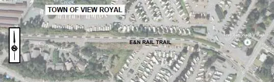
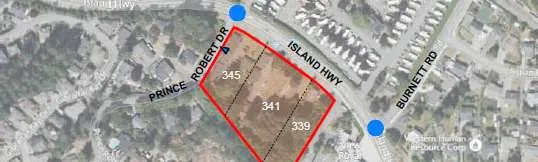
Figure 1: Study Area and Site Location
2.0 EXISTING CONDITIONS
2.1 LAND USE
The proposed development site is composed of three residential lots (339 / 341 / 345 Island Highway) and the existing land use is multi-family residential rental units. The surrounding area of the development is mostly residential along Island Highway and Prince Robert Drive. The View Royal Fire Department buildings were recently constructed just east of the proposed site on Island Highway. To the north, across from the development, there is the Fort Victoria RV Park.
2.2 ROAD NETWORK
The proposed development is located on the south side of Island Highway between Prince Robert Drive and View Royal Fire Department. Island Highway is under the jurisdiction of the Ministry of Transportation and Infrastructure. Burnett Road and Jedburgh Road are under the jurisdiction of the Town of View Royal. All roads within the study area have a maximum speed limit of 50 km/h. A description of all relevant roads in the area is provided below.
Island Highway is a two-lane highway with a functional classification as a Major Road. There are many private property accesses present, and the turning movements associated with them cause conflict and delay along the corridor. There are bike lanes on both sides, but limited sidewalks along most of the roadway (new sidewalk installed along the View Royal Fire Department frontage).
Prince Robert Drive is a two-lane local road (site access road), which faces the west side of the development. There is no sidewalk and limited shoulders provided along the roadway.
The intersection of Island Highway / Prince Robert Drive is stop-controlled with no separate turn lanes. Sight distance for northbound left turning traffic (looking to the left along the highway) from Prince Robert Drive is limited due to the horizontal curvature and vegetation.
Burnett Road is a two-lane local road connecting to Island Highway from just south of Highway 1 and the Fort Victoria RV Park. At the intersection of Island Highway / Burnett Road, there is a separate eastbound left turn lane in front of the Fire Department. During the AM peak period left turning vehicles (turning from Burnett Road onto Island Highway) were observed finding refuge in the painted median area before merging into the extensive eastbound queues. A new pedestrian activated signal was installed at the Fire Department frontage on Island Highway and the previous pedestrian signal at the bus stops east of Prince Robert Drive was removed.
Jedburgh Road is a two-lane local road providing a connection between Island Highway and Helmcken Road. The intersection at Island Highway is a right-in / right-out access and is spaced just 60m from the Burnett Road intersection.
2.3 TRAFFIC VOLUMES
Traffic counts were undertaken during the AM and PM peak hours on Tuesday November 15, 2022, at three study intersections on Island Highway: Prince Robert Drive, Burnett Road, and Jedburgh Road. 2022 counts were compared to 2021 counts which were undertaken during the COVID-19 pandemic (measured in April 2021), results showed that 2022 measured volumes are 11 % higher for the AM peak hour than 2021 volumes and 4.7% higher for the PM peak hour. The 2022 measured volumes are considered as the normal level before the COVID-19 pandemic. 2022 measured volumes were used for the existing conditions analysis without applying a scaling factor due to the pandemic. However, turning volumes at the side streets were chosen with higher values of 2021 and 2022 counts for a conservative analysis. Figure 2 shows the existing volumes used in this study.
Figure 2: 2022 Existing Volumes
2.4 TRAFFIC MODELLING – BACKGROUND INFORMATION
Analysis of the traffic conditions at the intersections within the study area were undertaken using Synchro traffic analysis software.
Synchro / SimTraffic is a two-part traffic modelling software that provides analysis of traffic conditions based on traffic-control, geometry, volumes, and traffic operations. Synchro software (Synchro 9/10) provides analysis using the Highway Capacity Manual (2010) methodology, while SimTraffic integrates established driver behaviors and characteristics to simulate actual conditions by randomly “seeding” vehicles travelling throughout the network. Outputs of the Synchro software include Level Of Service (LOS), delay (seconds per vehicle), and 95th percentile queue length (in vehicles, assuming 7.5m per vehicle).
LOS is broken down into six letter grades, with LOS A being excellent operations, and LOS F being unstable / failure operations. LOS C is generally considered to be an acceptable LOS by most municipalities. LOS D is generally considered to be on the threshold between acceptable and unacceptable operations. A description of LOS and Synchro is provided in Appendix A.
Volume-to-Capacity ratios are also considered in assessing the roadway network or determining required traffic control improvements. According to the city’s guidelines, for individual movements, the minimum acceptable V/C ratio is 0.95 used as a general threshold for mitigation.
2.5 2022 EXISTING TRAFFIC CONDITIONS
The existing traffic conditions were analyzed at the three study intersections. It was observed that significant congestion occurred, particularly for the Island Highway eastbound in the AM peak hour. At Island Highway / Prince Robert Drive, the stop-controlled northbound movement operates at LOS D in the AM / PM peak hour while movements along Island Highway operate at LOS A/B. The westbound left 95th percentile queue length was estimated at 12m during the AM / PM peak hour. It was observed that the eastbound through traffic (moving slow due to congestion) on Island Highway mostly stopped to yield to westbound left turn vehicles at Prince Robert Drive in the AM peak hour.
At Island Highway / Burnett Road, the stop-controlled southbound movement operates at LOS D in the AM and PM peak hours. The estimated eastbound left queues (15m or less) stay within the existing storage length (20m).
The intersection of Island Highway / Jedburgh Road operates at LOS C or better for all movements in the AM and PM peak hours. See Table 1 for the results of the analysis.
TABLE 1: 2022 EXISTING CONDITIONS
| INTERSECTION | MOVEMENT | AM Peak Hour | AM Peak Hour | AM Peak Hour | AM Peak Hour | PM Peak Hour | PM Peak Hour | PM Peak Hour | PM Peak Hour |
|---|---|---|---|---|---|---|---|---|---|
| LOS | Delay (s) | v/c Ratio | Queue (m)* | LOS | Delay (s) | v/c Ratio | Queue (m)* | ||
| ISLAND HWY / PRINCE ROBERT DR (EB/WB=ISLAND HWY) | EBTR | A | 0.0 | - | 5.3 | A | 0.0 | - | 2.4 |
| WBLT | B | 10.3 | 0.02 | 11.5 | A | 9.1 | 0.01 | 12.0 | |
| NBLR | D | 29.8 | 0.16 | 12.1 | D | 31.6 | 0.15 | 8.9 | |
| ISLAND HWY / BURNETT RD (EB/WB=ISLAND HWY) | EBL | A | 8.8 | 0.04 | 10.8 (20) | B | 10.5 | 0.07 | 15.2 (20) |
| EBT | A | 0.0 | - | 7.9 | A | 0.0 | - | 4.6 | |
| WBTR | A | 0.0 | - | 4.6 | A | 0.0 | - | 8.3 | |
| SBLR | D | 29.5 | 0.29 | 13.4 | D | 32.7 | 0.28 | 15.8 | |
| ISLAND HWY / JEDBURGH RD (EB/WB=ISLAND HWY) | EBT | A | 0.0 | - | 5.5 | A | 0.0 | - | 9.8 |
| WBTR | A | 0.0 | - | 3.6 | A | 0.0 | - | 11.0 | |
| SBR | B | 12.5 | 0.05 | - | C | 17.9 | 0.04 | - |
*Note: 95th Queues based on SimTraffic results (averaged from five simulation runs); (##) = Existing Storage Length
3.0 POST DEVELOPMENT
3.1 PROPOSED LAND USE
The proposed development is three multi-family residential buildings (mid-rise) with 238 dwelling units. See Figure 3 for the site plan and access.
3.2 SITE ACCESS
The existing site (3 lots) currently has driveways that connect to Island Highway. For the new development, the proposed access is located on Prince Robert Drive, 40 m south of Island Highway, while the current accesses onto Island Highway would be closed. The proposed access satisfies the Transportation Association of Canada (TAC) suggested minimum corner clearance (15m) to an access at stop-controlled major intersections for local roads. It is assumed that all site trips use the intersection of Island Highway / Prince Robert Drive for entering / exiting.
Figure 3: Site Plan and Access
3.3 TRIP GENERATION
The proposed development consists of two six-storey buildings with 238 residential rental units. For the purposes of this study, a previous site plan consisting of 260 residential units was analyzed. This represents the worst case scenario.
Trip generation rates were estimated using the 11th Edition of the ITE Trip Generation Manual. Trip generation rates for the weekday AM and PM peak hours are shown in Table 2.
Table 3 shows the estimated trips generated by the proposed development of multi-family residential use (mid-rise buildings). The development is expected to generate a net 96 weekday AM peak hour trips, and 101 weekday PM peak hour trips. These estimated vehicle trips are considered conservative, as the existing site trips were not deducted from the opening day background volumes.
TABLE 2: PEAK HOUR TRIP GENERATION RATES
| ITE Land Use | Weekday AM | Weekday AM | Weekday AM | Weekday PM | Weekday PM | Weekday PM | |
|---|---|---|---|---|---|---|---|
| Code | Description | Rate | In | Out | Rate | In | Out |
| 221 | Multi-Family Housing (Mid-Rise) | 0.37 | 23% | 77% | 0.39 | 61% | 39% |
TABLE 3: ESTIMATED DEVELOPMENT TRIPS
| Description | Units | Weekday AM | Weekday AM | Weekday AM | Weekday PM | Weekday PM | Weekday PM |
|---|---|---|---|---|---|---|---|
| In | Out | Total | In | Out | Total | ||
| Multi-family (Mid-Rise) | 260 | 22 | 74 | 96 | 62 | 39 | 101 |
3.4 TRIP ASSIGNMENT
The trip assignment was based on existing trip distributions for traffic in the area and key destinations / origins. Table 4 summarizes the distribution percentages of the site trips at the study intersections, while trip assignments are shown in Figure 4.
TABLE 4: DISTRIBUTION PERCENTAGES OF SITE TRIPS
| AM Peak Hour | PM Peak Hour |
|---|---|
| • 65% of trips to Island Hwy East | • 35% of trips to Island Hwy East |
| • 35% of trips to Island Hwy West | • 65% of trips to Island Hwy West |
| • 80% of trips from Island Hwy East | • 30% of trips from Island Hwy East |
| • 20% of trips from Island Hwy West | • 70% of trips from Island Hwy West |
Figure 4: Trip Assignment
3.5 2025 OPENING DAY BACKGROUND CONDITIONS
It is assumed that the opening day is in 2025. 2025 base volumes were projected using a 1.2% annual growth rate scaled up from the 2022 volumes. The 1.2% annual growth rate was estimated based on the 2018 counts at Island Highway / Helmcken Road and the Crown Regional District’s (CRD) historical data in the area. 2025 background conditions for the opening day were analyzed for the three key intersections based on the estimated 2025 volumes and current traffic control / laning.
At Island Highway / Prince Robert Drive, the stop-controlled northbound movement will continue to operate at LOS D in the AM / PM peak hour. The westbound left queues on Island Highway will increase slightly to 13m / 16m in the AM / PM peak hour.
At Island Highway / Burnett Road, the stop-controlled southbound movement will continue to operate at LOS D in the AM peak hour but drop to LOS E in the PM peak hour. The estimated eastbound left queues (14m or less) stay within the existing storage length (20m).
The intersection of Island Highway / Jedburgh Road will continue to operate at LOS C or better for all movements in the AM and PM peak hours. See Table 5 for the results of the analysis. See Figure 5 for 2025 opening day background volumes.
TABLE 5: 2025 OPENING DAY BACKGROUND CONDITIONS
| INTERSECTION | MOVEMENT | AM Peak Hour | AM Peak Hour | AM Peak Hour | AM Peak Hour | PM Peak Hour | PM Peak Hour | PM Peak Hour | PM Peak Hour |
|---|---|---|---|---|---|---|---|---|---|
| LOS | Delay (s) | v/c Ratio | Queue (m)* | LOS | Delay (s) | v/c Ratio | Queue (m)* | ||
| ISLAND HWY / PRINCE ROBERT DR (EB/WB=ISLAND HWY) | EBTR | A | 0.0 | - | 6.0 | A | 0.0 | - | 1.8 |
| WBLT | B | 10.4 | 0.02 | 12.7 | A | 9.2 | 0.01 | 15.9 | |
| NBLR | D | 32.0 | 0.18 | 12.4 | D | 34.2 | 0.17 | 9.6 | |
| ISLAND HWY / BURNETT RD (EB/WB=ISLAND HWY) | EBL | A | 8.9 | 0.04 | 11.4 (20) | B | 10.5 | 0.07 | 13.9 (20) |
| EBT | A | 0.0 | - | 5.0 | A | 0.0 | - | 3.8 | |
| WBTR | A | 0.0 | - | 4.4 | A | 0.0 | - | 9.7 | |
| SBLR | D | 33.4 | 0.34 | 13.6 | E | 35.5 | 0.31 | 14.8 | |
| ISLAND HWY / JEDBURGH RD (EB/WB=ISLAND HWY) | EBT | A | 0.0 | - | 4.1 | A | 0.0 | - | 10.3 |
| WBTR | A | 0.0 | - | 4.3 | A | 0.0 | - | 16.1 | |
| SBR | B | 12.7 | 0.05 | - | C | 18.6 | 0.04 | - |
*Note: 95th Queues based on SimTraffic results (averaged from five simulation runs); (##) = Existing Storage Length
Figure 5: 2025 Opening Day Background Volumes
3.6 OPENING DAY POST DEVELOPMENT CONDITIONS
The opening day post-development conditions were analyzed by adding the development trips to background traffic volumes.
At Island Highway / Prince Robert Drive, the northbound movement drops to LOS F in the AM / PM peak hour with the development. A maximum V/C ratio remains at 0.82 for the northbound movement, which does not exceed a general threshold (0.95) for mitigation. The westbound left turn volumes were estimated at 25 / 26 vehicles in the AM / PM peak hour with the development. The estimated westbound left queues increase to unacceptable lengths of 26m / 29m during the AM / PM peak hour; a westbound left turn lane should be considered. The northbound queue length on Prince Robert Drive was estimated at 30m in the AM peak hour which does not block the proposed access (35m spaced from Island Highway).
Based on the 2025 AM / PM post development volumes, a westbound left turn lane is warranted (BC MOTI Warrant manual). A dedicated westbound left turn lane should be installed for safety with the development. Implementation of a westbound left turn lane makes delays at the side street slightly less based on the Synchro result. As an alternative traffic control for Island Highway / Prince Robert Drive, the warrant analysis for a traffic signal is described in Section 5.3.
The proposed development will have little impact on traffic operations at the other two study intersections. At Island Highway / Burnett Road, the stop-controlled southbound movement will drop to LOS E (average delay: 37.4 seconds) with 2-4 seconds of additional delays in the AM and PM peak hours with no queuing issue. The intersection of Island Highway / Jedburgh Road will continue to operate at LOS C or better for all movements in the AM and PM peak hours.
See Table 6 for the results of the analysis. See Figure 6 for the Opening Day post development volumes.
TABLE 6: 2025 OPENING DAY POST DEVELOPMENT CONDITIONS
| INTERSECTION | MOVEMENT | AM Peak Hour | AM Peak Hour | AM Peak Hour | AM Peak Hour | PM Peak Hour | PM Peak Hour | PM Peak Hour | PM Peak Hour |
|---|---|---|---|---|---|---|---|---|---|
| LOS | Delay (s) | v/c Ratio | Queue (m)* | LOS | Delay (s) | v/c Ratio | Queue (m)* | ||
| ISLAND HWY / PRINCE ROBERT DR (EB/WB=ISLAND HWY) | EBTR | A | 0.0 | - | 5.0 | A | 0.0 | - | 3.1 |
| WBLT | B | 10.7 | 0.06 | 26.4 | A | 9.6 | 0.04 | 29.2 | |
| NBLR | F | 86.7 | 0.82 | 29.6 | F | 102 | 0.74 | 21.5 | |
| ISLAND HWY / BURNETT RD (EB/WB=ISLAND HWY) | EBL | A | 9.0 | 0.05 | 10.5 (20) | B | 10.8 | 0.07 | 13.4 (20) |
| EBT | A | 0.0 | - | 9.6 | A | 0.0 | - | 8.3 | |
| WBTR | A | 0.0 | - | 4.6 | A | 0.0 | - | 7.8 | |
| SBLR | E | 37.4 | 0.37 | 13.3 | E | 37.4 | 0.32 | 15.4 | |
| ISLAND HWY / JEDBURGH RD (EB/WB=ISLAND HWY) | EBT | A | 0.0 | - | 6.3 | A | 0.0 | - | 10.9 |
| WBTR | A | 0.0 | - | 2.1 | A | 0.0 | - | 19.9 | |
| SBR | B | 12.9 | 0.05 | 2.3 | C | 19.0 | 0.05 | 3.5 |
*Note: 95th Queues based on SimTraffic results (averaged from five simulation runs); (##) = Existing Storage Length
Figure 6: Opening Day Post Development Volumes
4.0 2035 10-YEAR HORIZON TRAFFIC CONDITIONS
For the ten-year horizon analysis, 2035 background volumes were obtained using an annual growth rate of 1.2% from 2022 measured volumes. See Figure 7 for 2035 peak hour background volumes.
Figure 7: 2035 Ten-year Horizon Background Volumes
4.1 2035 BACKGROUND CONDITIONS
2035 background conditions were analyzed for the three study intersections. At Island Highway / Prince Robert Drive, the northbound movement is expected to operate at LOS E in the AM / PM peak hour due to high through volumes on Island Highway.
At Island Highway / Burnett Road, the southbound movement will drop to LOS E / F due to high through volumes on Island Highway in the AM / PM peak hour. This degradation in LOS is based on general Island Highway volume increases with little direct impact from the development.
The intersection of Island Highway / Jedburgh Road will continue to operate at LOS C or better for all movements in the AM and PM peak hours. See Table 7 for the results of the 2035 background analysis.
TABLE 7: 2035 BACKGROUND CONDITIONS
| INTERSECTION | MOVEMENT | AM Peak Hour | AM Peak Hour | AM Peak Hour | AM Peak Hour | PM Peak Hour | PM Peak Hour | PM Peak Hour | PM Peak Hour |
|---|---|---|---|---|---|---|---|---|---|
| LOS | Delay (s) | v/c Ratio | Queue (m)* | LOS | Delay (s) | v/c Ratio | Queue (m)* | ||
| ISLAND HWY / PRINCE ROBERT DR (EB/WB=ISLAND HWY) | EBTR | A | 0.0 | - | 1.3 | A | 0.0 | - | 4.3 |
| WBLT | B | 10.9 | 0.02 | 25.3 | A | 9.6 | 0.01 | 25.0 | |
| NBLR | E | 40.9 | 0.24 | 13.9 | E | 48.6 | 0.26 | 11.4 | |
| ISLAND HWY / BURNETT RD (EB/WB=ISLAND HWY) | EBL | A | 9.1 | 0.05 | 11.8 (20) | B | 11.5 | 0.09 | 15.1 (20) |
| EBT | A | 0.0 | - | 5.9 | A | 0.0 | - | 10.9 | |
| WBTR | A | 0.0 | - | 4.5 | A | 0.0 | - | 11.9 | |
| SBLR | E | 46.3 | 0.46 | 16.5 | F | 55.5 | 0.46 | 18.0 | |
| ISLAND HWY / JEDBURGH RD (EB/WB=ISLAND HWY) | EBT | A | 0.0 | - | 6.2 | A | 0.0 | - | 16.9 |
| WBTR | A | 0.0 | - | 6.2 | A | 0.0 | - | 25.5 | |
| SBR | B | 13.6 | 0.06 | - | C | 21.5 | 0.06 | - |
*Note: 95th Queues based on SimTraffic results (averaged from five simulation runs); (##) = Existing Storage Length
4.2 2035 POST DEVELOPMENT ANALYSIS RESULTS
2035 post development conditions were analyzed by adding the development trips to 2035 background traffic volumes.
At Island Highway / Prince Robert Drive, the northbound movement drops to LOS F in the AM and PM peak hours with the development. The estimated westbound left queues are unacceptable with 48m / 56m in the AM / PM peak hours under the current laning (no left turn lane). A westbound left turn lane should be installed with the development for safety. If a westbound left turn lane was added on Island Highway at Prince Robert Drive, the estimated left queues reduce to 12-13m in the peak hours. At the intersection, the maximum V/C ratio was estimated at 1.02 / 1.09 for the northbound movement in the AM / PM peak hour, which exceeds the general mitigation threshold of 0.95. The northbound delay was estimated at 151 / 227 seconds in the AM / PM peak hour.
At Island Highway / Burnett Road, the southbound movement will operate at LOS F in the AM/PM peak hours. However, additional delays caused by the development will be marginal with 6 seconds in the AM peak hour and 3 seconds in the PM peak hour. The intersection of Island Highway / Jedburgh Road will continue to operate at LOS C or better for all movements in the AM and PM peak hours with the development.
See Table 8 for the results of the 2035 post development analysis. See Figure 8 for 2035 post development volumes.
TABLE 8: 2035 POST DEVELOPMENT CONDITIONS
| INTERSECTION | MOVEMENT | AM Peak Hour | AM Peak Hour | AM Peak Hour | AM Peak Hour | PM Peak Hour | PM Peak Hour | PM Peak Hour | PM Peak Hour |
|---|---|---|---|---|---|---|---|---|---|
| LOS | Delay (s) | v/c Ratio | Queue (m)* | LOS | Delay (s) | v/c Ratio | Queue (m)* | ||
| ISLAND HWY / PRINCE ROBERT DR (EB/WB=ISLAND HWY) | EBTR | A | 0.0 | - | 6.5 | A | 0.0 | - | 3.7 |
| WBLT | B | 11.2 | 0.07 | 48.1 (12) | B | 10.0 | 0.05 | 56.3 (13) | |
| NBLR | F | 151 | 1.02 | 34.5 | F | 227 | 1.09 | 27.6 | |
| ISLAND HWY / BURNETT RD (EB/WB=ISLAND HWY) | EBL | A | 9.2 | 0.05 | 12.2 (20) | B | 11.7 | 0.09 | 15.0 (20) |
| EBT | A | 0.0 | - | 10.5 | A | 0.0 | - | 10.5 | |
| WBTR | A | 0.0 | - | 6.5 | A | 0.0 | - | 9.7 | |
| SBLR | F | 52.5 | 0.50 | 15.9 | F | 58.4 | 0.47 | 20.2 | |
| ISLAND HWY / JEDBURGH RD (EB/WB=ISLAND HWY) | EBT | A | 0.0 | - | 4.9 | A | 0.0 | - | 12.6 |
| WBTR | A | 0.0 | - | 2.6 | A | 0.0 | - | 18.4 | |
| SBR | B | 13.9 | 0.06 | - | C | 21.9 | 0.06 | 1.9 |
*Note: 95th Queues based on SimTraffic results (averaged from five simulation runs); (##) = Existing Storage Length (##) = Estimated queue length with a dedicated left turn lane
Figure 8: 2035 Post Development Volumes
5.0 OPERATIONAL CONSIDERATIONS
5.1 IMPROVEMENTS FOR ISLAND HIGHWAY / PRINCE ROBERT DRIVE
According to ICBC crash data, at Island Highway / Prince Robert Drive, five (6) crashes (2 injury type) were reported from 2017-2021. At Island Highway / Burnett Road, there was one (1) crashes reported in the same period even though the Burnett intersection currently has 2.5 times more turning volumes (148 vs 60 during the AM & PM peak hours) than the Prince Robert intersection.
At Island Highway / Prince Robert Drive, the crashes observed are likely the result of roadway geometry issues. The stopping location for traffic turning from Prince Robert Drive has poor sight distance looking to the left (along Island Highway) due to the horizontal curvature and vegetation. The available sight distance was measured at 65m, which just meets TAC minimum stopping sight distance for 50 km/h roadways. The available sight distance does not meet the required intersection sight distance (105m) for left turning vehicles starting from a stop on a 50 km/h, two lane road.
A westbound left turn lane should be considered on Island Highway at Prince Robert Drive. Based on the 2035 post development volumes the MOTI warrant chart recommends a 25-35m storage length, however the SimTraffic results show a 15m storage length is needed. Current right of way on Island Highway appears sufficient to implement roadway improvements including a new left turn lane and corresponding realignment. See Section 5.2 for more detail and see Appendix B for preliminary design.
On Island Highway, traffic conditions for the two intersections (Prince Robert Drive and Burnett Road) are similar; movements from the side streets will be worse (LOS F during peak hours) as the highway through-traffic increases. Signalization for the Prince Robert Drive intersection should be considered if volumes at the side street approach a threshold volume level (75 vph) as the highway through volumes on Island Highway are already high enough with over 1,500 vph (both directions) in the peak hours.
5.2 LEFT TURN LANE
At the Island Highway / Prince Robert Drive intersection, a left turn lane is warranted for the westbound movement based on 2025 opening day AM & PM peak hour volumes with or without the development. The need for the turn lane increases with the development, but the lane is warranted without it. A 25m westbound left turn lane is required based on the 2025 and 2035 post development analysis results. See Figure 9 for the left turn lane warrant review.
It should be noted that making left turns into / out of the RV park/housing on Island Highway is difficult today due to the background traffic. One remedy would be to add not only the dedicated left turn lane, but to extend that turn lane from Prince Robert Drive to the eastbound left turn lane at Burnett Road using a Two-Way-Left-Turn-Lane (TWLTL). This would give the RV park and the residences on Island Highway a safer turn situation and would tie into the existing painted median and turn lanes. It would also aid westbound Fire dispatch by giving the Fire trucks / passenger vehicles a space to travel / move into.
Figure 9: Left Turn Lane Warrant Review
5.3 SIGNAL WARRANT REVIEW FOR 4-LEG ISLAND HWY / PRINCE ROBERT DRIVE
At Island Highway / Prince Robert Drive, there is an access on Island Highway to the existing RV Park across the development site. The RV Park access is located slightly offset (approximately 7m) from Prince Robert Drive (south leg). During traffic counts it was observed there were very few vehicles that made left turns (4 vph AM Peak and 2 vph PM peak) from Island Highway into the RV Park site. No exiting vehicle was observed from the RV Park access and the RV park traffic can (and clearly prefers to) use Burnett Road to exit to the east. Because of these low volumes the leg was excluded from the above analysis.
As a worst-case scenario, the intersection operations were analyzed with a 4-leg option (north leg added) rather than 3-legs. Table 9 summarizes Synchro results for the northbound movement at Island Highway / Prince Robert Drive with 3-leg and 4-leg options. Comparing delays for the northbound movement (already over capacity conditions with 3-legs), the 4-leg option will have roughly double the delay compared to the 3-leg due to very high through volumes on Island Highway. This dramatic increase is due to a small number of vehicles which have the option of turning into the access at Burnett Road, which has a dedicated turn lane. Further, the addition on the proposed turn lane will address most of the delays seen in Table 9.
TABLE 9: DELAY COMPARISON BETWEEN 3-LEG AND 4-LEG OPTIONS
| Peak Hour | NB Average Delay – 3 Legs | NB Average Delay – 4 Legs |
|---|---|---|
| Opening Day Post Development AM | LOS F: 87 sec | LOS F: 159 sec |
| Opening Day Post Development PM | LOS F: 102 sec | LOS F: 208 sec |
| 10-Year Horizon Post Development AM | LOS F: 151 sec | LOS F: 279 sec |
| 10-Year Horizon Post Development PM | LOS F: 227 sec | LOS F: 443 sec |
5.3.1 SIGNAL WARRANT ANALYSIS
A full signal warrant review was undertaken with a 4-leg option at the Island Highway / Prince Robert Drive intersection, See Appendix C: Traffic Signal Warrant Results. The signal warrant review is based on the BC MoTI’s Electrical & Traffic Engineering Design Guidelines (Section 400, Signal Design). The warrant assessment includes nine (9) warrant requirements. Three of the nine warrants were non-applicable due lack of data. Appendix C: Traffic Signal Warrant Results shows the results, which are discussed below.
- Warrant 1: Minimum Vehicular Volume is not met as side street volume of the intersection is lower than the required threshold (150 vph).
- Warrant 2: Interruption of Continuous Traffic is met for the AM Opening Day and 2035 Post-Development scenarios.
- Warrant 3: Progressive Movement is not applicable.
- Warrant 4: Collision Experience does not satisfy the conditions (minimum five collisions experienced within one year) with 6 collisions over five years.
- Warrant 5: System Warrant has been met for the AM Opening Day and 2035 Post-Development scenarios.
- Warrant 6: Combination Warrant is not applicable.
- Warrant 7: Four Hour Volume Warrant cannot be fully analyzed because 4-hour count data was not obtained, however the peak hour results alone mean the warrant is likely met, mainly due to the 80vph minor street volumes.
- Warrant 8: Peak Hour Delay is not met as all three conditions must be met, and the highest minor leg does not exceed 100vph.
- Warrant 9: Peak Hour Volume is not warranted based on estimated 2035 post development peak hour volume due to side street volumes being less than 100 vph.
At Island Highway / Prince Robert Drive, addition of the north leg increases delays significantly for the northbound movement (Prince Robert Drive with stop control). For 10-year horizon post development peak hours, the intersection will experience extremely long delays for the northbound movement with the north leg under stop control. For the opening day post development AM peak hour, total delay from the northbound movement exceeds 4 vehicle-hours of delay required for Warrant 8, although the warrant fails to be met. See Table 10 for the total delay result of the post development peak hour analysis (Synchro HCM 2010) at Island Highway / Prince Robert Drive with a new north leg.
TABLE 10: NORTHBOUND DELAYS AT ISLAND HWY / PRINCE ROBERT DR
| Peak Hour | Total Delay | Warrant Condition Met? |
|---|---|---|
| Opening Day Post Development AM | 4.02 vehicle-hours | Yes |
| Opening Day Post Development PM | 2.95 vehicle-hours | No |
| 10-Year Horizon Post Development AM | 7.21 vehicle-hours | Yes |
| 10-Year Horizon Post Development PM | 6.51 vehicle-hours | Yes |
5.3.2 TRAFFIC SIGNAL WARRANT RESULT
The warrant results are somewhat marginal as only two warrants are met. As the MoTI manual notes, the determination of whether a signal is to be installed is not based solely on meeting of any one (or more) warrants. Additional factors must be considered in the final determination, including local plans and regulations, general safety, etc. Additional factors that should be considered are as follows:
- Is this the best location for a signal on the corridor?
- Burnett Road could benefit from signalization.
- Will future Fort Victoria changes dictate a better placement?
- The curve in the road affects the signal visibility.
- Increase in signal related crashes especially for eastbound traffic due to the curve in the roadway are highly likely.
- Primarily rear end collisions, but also side crashes.
- Visibility of signal heads eastbound may be an issue and advance signal heads, and possibly other measures, may be required.
- Only 2 Warrants are met, and only met for AM condition, and then not by much.
- ITE 11th Ed. trip generation does not capture post-pandemic change in work patterns and therefore may not be an accurate description of actual conditions when the development is fully occupied. A slight drop in the assumed trip generation rate in the AM peak hour (caused by a change to work from home) increases the marginality of the warrants.
- An alternate route to Helmcken is available, but is quite far (1.1km detour).
- On Island Highway at Prince Robert Drive, existing volumes are in the highest range (1600 – 1800 vph) of the peak hour MoTI manual signal warrant volume chart.
- For the 10-year horizon post development peak hour, the estimated v/c ratio for the northbound movement exceeds 1.5, which is much higher than a general threshold (0.95) for mitigation.
Based on the above results and discussion with the municipality a traffic signal is recommended at the intersection.
5.4 FEASIBILITY REVIEW OF ON-STREET PARKING
The feasibility of on-street parking along Island Highway was reviewed. Currently there is no on-street parking provided on Island Highway adjacent to the site. On-street parking typically can lead to reduce road capacity and decrease traffic performance of the certain roads based on related parameters. The feasibility of on-street parking is directly related to the existing road conditions. Traffic volumes and capacity of road are considered key parameters to determine the feasibility of implementation of on-street parking.
Existing traffic volumes along Island Highway are nearly at saturated a condition with 1,500-1,600 vehicles during the peak hours. Particularly for the eastbound movement, significant traffic congestion occurs along the corridor in the AM peak hours. The implementation of on-street parking (parallel parking) could negatively impact road capacity and flow efficiency by increasing side friction under the current congested conditions. Furthermore, on-street parking along the Island Highway frontage would be not suitable due to the limited right-of-way. Significant road cross section improvements are required. A westbound left turn lane should be required on Island Highway and a traffic signal should also be considered at the Price Robert Drive intersection as an alternative traffic control. There is a transit bus stop to be upgraded at the development frontage. The frontage improvements also require a new paved shoulder and wide sidewalk with boulevards to connect to the existing sidewalk network to the east.
These safety/operational changes far outweigh the need for a small number of parking spaces and the friction they will create with the adjacent traffic stream will negatively impact general flow; taken together the parking should not built.
6.0 ACTIVE TRANSPORTATION
6.1 PEDESTRIANS AND CYCLING FACILITIES
The E&N Rail Trail passes close to the north side of Island Highway within a 300m distance from the site. There are sidewalks along the east side of Burnett Road and along the Fire Department frontage of Island Highway. There are no sidewalks along the development frontage of Island Highway. Based on the ITE Trip Generation Manual, the development (260 multi-family units) will generate 4-5 pedestrian trips during the peak hour. According to the TMP a 2.0m sidewalk with landscaped boulevards is recommended along the development frontage of Island Highway from Prince Robert Drive to the existing sidewalk at the Fire Department. Connection to the pathway could be completed by constructing the sidewalk along Island Highway.
There are bike lanes along both sides of Island Highway. If a left turn lane is installed on Island Highway the bike lanes should be preserved. Prince Robert Drive is currently just 6m wide with no paved shoulders along the development frontage. With the development, the cross section for Prince Robert Drive would be upgraded with a paved shoulder along the development frontage for pedestrian / cyclist safety.
6.2 TRANSIT
The bus route No. 46 passes in front of the proposed site on Island Highway providing service from Langford (Westhills Exchange) to Esquimalt (HMC Dockyard) via the Colwood Exchange two times per peak hours on weekdays. Currently, there is a bus stop at the development frontage on Island Highway. The existing bus stops should be upgraded when the development frontage improvements are made along Island Highway.
7.0 PARKING FACILITY REVIEW
The site is currently subject to the parking requirements outlined in Zoning Bylaw 2014 No. 900. The vehicular parking requirements applicable to the site are outlined in Table 11.
TABLE 11: ON-SITE PARKING REQUIREMENTS
| Use | Unit Count | Minimum Rate | Minimum Requirement |
|---|---|---|---|
| Studio + 1 Bedroom | 119 units | 1 space per unit | 119 spaces |
| 2 Bedroom | 114 units | 1.5 spaces per unit | 171 spaces |
| 3 Bedroom | 5 units | 2 spaces per unit | 10 spaces |
| Total | 238 units | 300 spaces |
A total of 300 parking spaces are required to be provided on the site.
A total of 300 parking spaces, distributed across two underground parking levels, are proposed to be provided. The proposed parking supply meets the requirements of Zoning Bylaw 2014 No. 900.
8.0 TRANSPORTATION DEMAND MANAGEMENT
Transportation Demand Management (TDM) is the application of strategies and policies to influence the travel choice of an individual, most commonly to reduce single-occupant vehicle travel. TDM measures typically aim to encourage sustainable travel, enhance travel options, and decrease parking demand.
As the proposed development is currently meeting the parking requirements outlined in Zoning Bylaw 2014 No. 900, there is limited need to apply transportation demand management measures to reduce parking demand for the proposed development. As such, no transportation demand management measures are currently being sought.
9.0 CONCLUSION
The proposed development will generate 96 vehicle trips in the AM peak hour and 101 vehicle trips in the PM peak hour. The development will have little impact on the traffic operations at the two adjacent intersections of Island Highway / Burnett Road, and Island Highway / Jedburgh Road, as the development adds only a small amount of through volume on Island Highway.
The development will impact traffic operations at Island Highway / Prince Robert Drive as significant turning volumes are added to the intersection. With the development the stop-controlled northbound movement will drop to LOS F (2025 opening day background LOS D) in the AM and PM peak hours in the short term. In the long term, the northbound movement will operate at LOS F with additional delays in both the AM and PM hours due to projected increase in through volumes on Island Highway. However, a traffic signal is not warranted based on 2035 post development peak hour volumes and delays, although signalization (or other traffic control) of the intersection should still be considered.
At Island Highway / Prince Robert Drive, a westbound left turn lane is warranted based on 2025 background traffic volumes and is strongly recommended. Additionally, this turn lane should be extended to the Burnett Road left turn lane using a TWLTL.
Prince Robert Drive should be upgraded with a paved shoulder along the development frontage. A sidewalk with landscaped boulevards is required along the development frontage of Island Highway to the existing sidewalk at the Municipal Fire Department. Construction of the sidewalk would also complete a connection to the E&N pathway.
On Island Highway, the existing bus stops in front of the site should be upgraded. On street parking along the Island Highway frontage is not recommended. The site access proposed on Prince Robert Drive is appropriately located from a safety perspective.
A traffic signal warrant process was undertaken for the 4-leg Prince Robert Drive intersection layout. Results show a marginally warranted signal with only two warrants being met. Additional considerations, including and expected increase in rear end crashes and whether the location is the correct one for the corridor as a whole must be weighed by the road authority before a final determination is made.
10.0 RECOMMENDED IMPROVEMENTS
The following improvements are recommended of the developer:
- Upgrade the cross section of Prince Robert Drive with a paved shoulder along the development frontage.
- Install a sidewalk with landscaped boulevards along the development frontage of Island Highway.
- Upgrade the existing bus stops as per BC Transit and View Royal direction.
The following improvements are recommended of the road authority:
- Install a 25m westbound left turn lane on Island Highway at Prince Robert Drive.
- Convert the painted median on Island Highway into a TWLTL.
- Install a traffic signal at the Prince Robert Drive intersection.