Official Community Plan Review and Update: What We Heard Report #4 – Western Gateway Community Corridor Engagement
A detailed summary of public feedback gathered regarding three land use concepts for the Western Gateway Corridor, highlighting community preferences for growth and development.
WHAT WE HEARD: ENGAGEMENT TOUCHPOINT 4
WESTERN GATEWAY COMMUNITY CORRIDOR SURVEY
The Western Gateway Community Corridor Survey was launched on October 7, 2025, and closed on November 12, 2025. The survey invited participants to provide feedback on three land use concepts for the Western Gateway Corridor, to determine the long-term land use and development of this area.
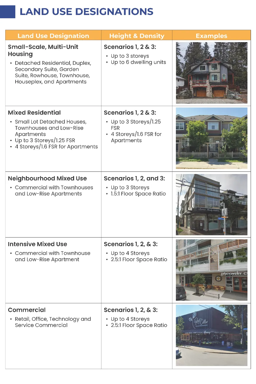
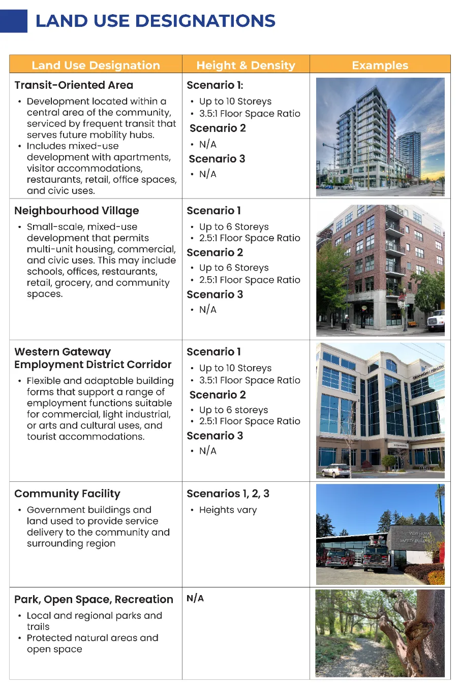
Participants were provided with a land use designation summary, which includes the permitted uses, heights, and densities for each land use designation. The table below includes both existing and proposed designations. The new draft land use designations considered for this engagement include the Transit-Oriented Area, Neighbourhood Village, and Western Gateway Employment District Corridor.
LAND USE DESIGNATIONS
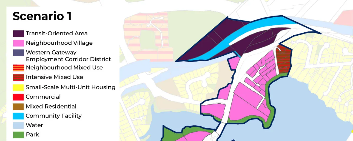
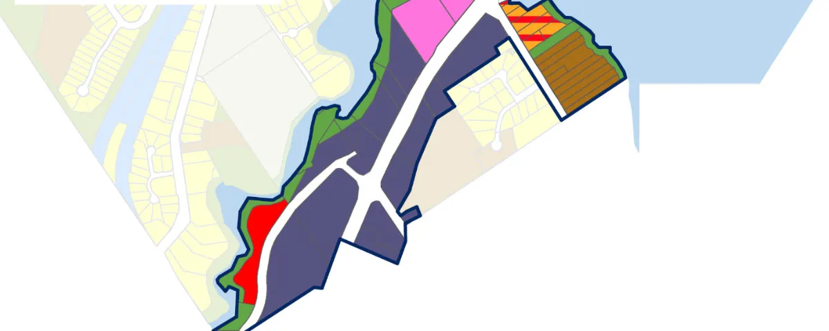
Scenario 1: High Growth
This scenario focuses on creating a high-density employment hub with a mix of commercial, light industrial, and community uses.
Key Features:
- Establishes a new Employment Corridor District supporting commercial, light industrial, civic, and arts and culture uses
- Introduces two mixed-use growth areas: Transit-Oriented Area and Neighbourhood Village
- Includes public gathering spaces and improved connections to transit and active transportation
- Waterfront park land designated for long-term parks and trails planning and flood protection
Potential Growth and Development:
- Residential units: 2200
- Population: 5100
- Commercial floor area: 238,500 m²
- Light industrial floor area: 160,400 m²
Figure 6: Scenario 1 - High Growth
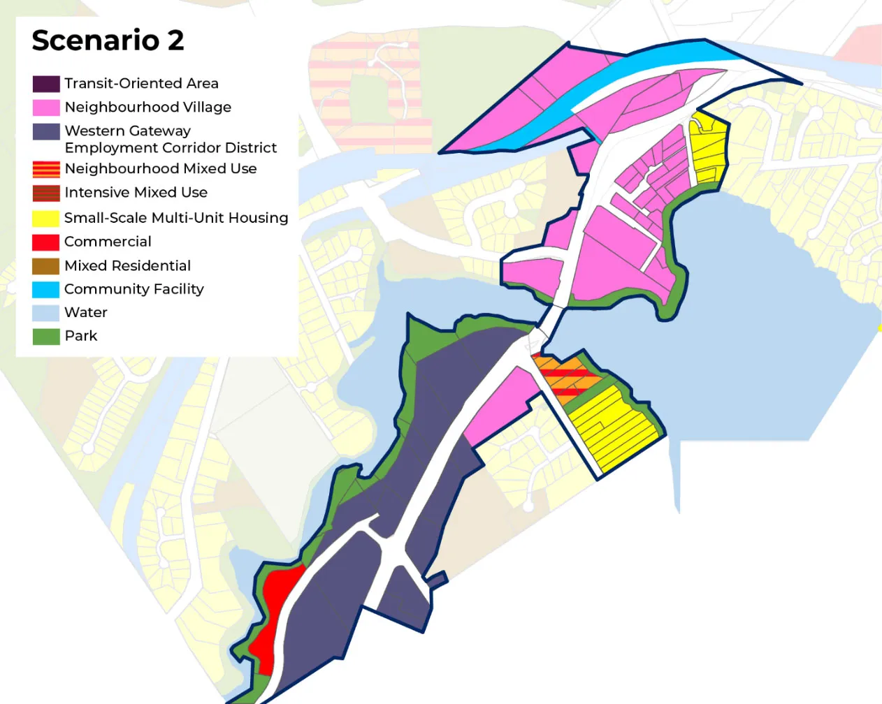
Scenario 2: Medium Growth
This scenario focuses on creating a medium-density employment hub with a mix of commercial, light industrial, and community uses.
Key Features:
- Establishes a new Employment Corridor District supporting commercial, light industrial, civic, and arts and culture uses
- Introduces a new growth area: Neighbourhood Village
- Introduces public gathering spaces and improved connections to transit and active transportation
- Waterfront park land designated for long-term parks and trails planning and flood protection
Potential Growth and Development:
- Residential units: 1700
- Population: 3900
- Commercial floor area: 204,200 m²
- Light industrial floor area: 155,500 m²
Figure 7: Scenario 2 - Medium Growth
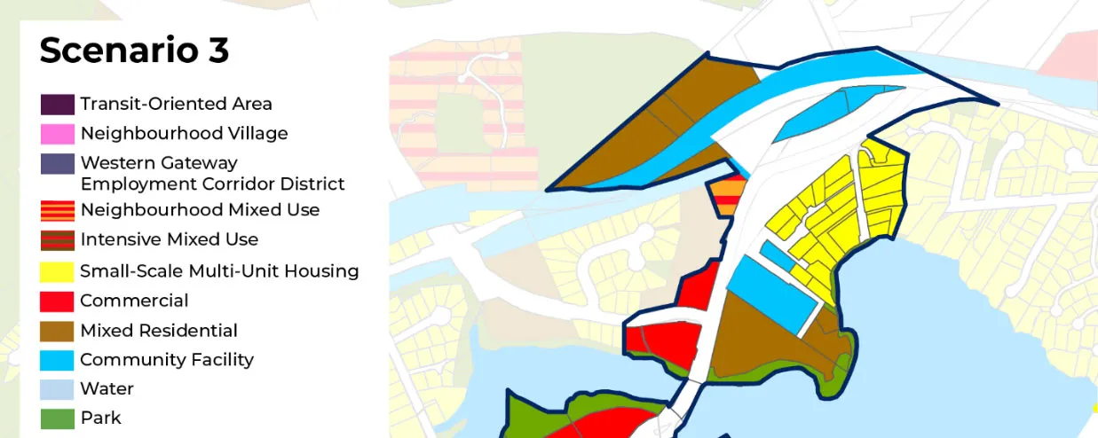
Scenario 3: Low Growth
This scenario is unchanged from the 2011 Official Community Plan and continues to focus on providing a mix of commercial uses along Island Highway with some low-density housing around the Atkins Interchange.
Key Features:
- Continues to permit a mix of commercial uses including general retail and service commercial
- Would not permit new land uses, such as light industry and civic uses, and would have limited potential to permit higher density mixed-use and residential development
- Does not include designated park land along the waterfront in all areas of the Western Gateway Community Corridor
Potential Growth and Development:
- Residential units: 1400
- Population: 3300
- Commercial floor area: 311,600 m²
- Light industrial floor area: 0 m²
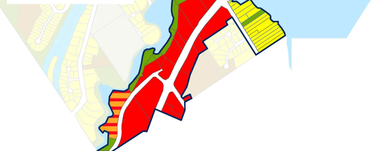
Figure 8: Scenario 3 - Low Growth
The display panels used at the open houses include additional information on these scenarios and can be found in Appendix A.
The survey also asked visioning questions to determine what values, challenges, and opportunities may exist in the area. In total, 59 survey responses were received.
OVERALL THEMES
Preferred Land Use Scenario
- The majority of respondents prefer Scenario 2: Medium growth (41%), followed closely by Scenario 1: High growth (34%). The responses indicate that 75% of respondents would prefer to see growth in the Western Gateway Community Corridor, as opposed to the 17% of respondents that would prefer to see no change from the existing land use (Scenario 3: Low Growth – status quo/no change).
Relationship to the Western Gateway Community Corridor
- 59% of respondents visit the area for shopping and services, recreation, or to commute through the area.
- 41% of respondents live in the Western Gateway Community Corridor
- 55% of respondents travel through the Western Gateway Community Corridor daily
- 36% of respondents stop a few times a week for a business or service, less than 5% of respondents said they stop daily, and 19% of respondents said they stop only once a week, a few times a month, or only a couple times per year.
- The majority of respondents said their primary purpose for visiting or traveling through the Western Gateway Corridor is for shopping, dining, or personal services (64%).
- Approximately 61% of respondents indicated that they travel through the Western Gateway to reach another destination.
Values and Priorities
- The majority of respondents indicated that the greatest value the Western Gateway provides is its role as a gateway between communities (54%).
- 80% of respondents said that the existing drawback for the Western Gateway Community Corridor today is the heavy traffic.
- 93% of respondents said that traffic and congestion is a challenge when thinking about this area in the future.
- 67% of respondents said that in the future, priority should be given to improving transit, cycling, and walking infrastructure.
- 46% of respondents are not sure of the employment diversity of the area
- 47% of respondents state that the greatest priority for mobility and connectivity improvements is to upgrade sidewalks
- Respondents felt strongly both about the quality of landscaping and sidewalks in the area. 55% of respondents said the priority should be in providing landscaping and street trees that provide shade, beauty and comfort. Whereas 53% of respondents said that sidewalks should be wide, continuous and accessible for all abilities.
WHO PARTICIPATED
- 86% of respondents are residents of View Royal
- 30% of respondents live in the Wilfert neighbourhood
- 61% of respondents live in a single detached house
- 94% of respondents own their home
- 18% of respondents are between the ages of 35 and 39, and 14% of respondents are between the ages of 65 and 69.
- 42% of respondents are new to View Royal within the last five years.
- 32% of respondents indicated they found out about the Western Gateway Community Corridor engagement process by both the Town of View Royal website and social media.
- 58% of respondents indicated that this was their first time engaging on the View Royal 2050: Our Future View Official Community Plan Review and Update.
SURVEY RESULTS
The following section provides a summary of results for questions 1 to 23 in the Western Gateway Community Corridor Survey, including the verbatim comments received.
Question 1: What is your connection to the Western Gateway Community Corridor?
Findings:
59% of respondents indicated that they either own, live, or commute within the Western Gateway Community Corridor, whereas 41% say they have no direct connection, and 36% say they visit the area for dining.
[Chart: Question 1: Connection to Western Gateway Community Corridor]
Other (Please Specify):
- Frequent use of the Galloping Goose and the trail intersection with the E&N trail. Enhancing the access to and the connection between those two major trail systems should be a key objective of the Western Gateway plan. And don't just tell people it will be taken care of in a transportation plan.
- I live next to the area.
Question 2: How often do you typically travel through the Western Gateway Community Corridor?
Findings:
The majority of respondents (55%) say they travel through the Western Gateway Community Corridor daily, whereas 31% of respondents say they travel a few times a week. Of all respondents, 14% say they travel less than or the equivalent of once a week.
[Chart: Question 2: Frequency of travel through the corridor]
Question 3: How often do you typically stop at a business or service along the Western Gateway Community Corridor?
Findings:
55% of respondents stop at a business in the Western Gateway Community Corridor at least once a week.
[Chart: Question 3: Frequency of stopping at businesses]
Question 4: What is your primary purpose for visiting or traveling through the Western Gateway Community Corridor?
Findings:
The majority of respondents indicated that their primary purpose for visiting or travelling through the Western Gateway Community Corridor is for shopping, dining, or personal services (64%). Nearly an equal number of respondents also indicated that passing through to reach another destination (60%) or recreation (59%) were also reasons.
[Chart: Question 4: Primary purpose for visiting or traveling through the corridor]
Other (Please Specify):
- Using transit. Accessing community services (Juan de Fuca rec centre). Visiting friends. Passing through to reach another destination. The fact is, if you live in View Royal you will travel through this area to other communities all the time. The Western Gateway has very few facilities that people visit frequently - car lots, a warehouse, a storage facility. It is unlikely that the commercial area SW of Parsons bridge will handle businesses with high traffic volumes without an access road on the north side of the current road - so plan accordingly.
- I live within the boundary
Question 5: What do you think is the best name for the northern border of the Western Gateway Community Corridor?
Findings:
The majority of respondents (39%) indicated that the “Atkins Interchange” should be used for the area of the Western Gateway Corridor that is located on the northern border.
[Chart: Question 5: Best name for northern border]
Other (Please Specify):
- Six Mile Interchange
- Burnside Island Hwy Y
- Do not use the word interchange, it dooms the area to being viewed as a concrete jungle. The area is already part of the Atkins neighbourhood in our OCP so perhaps Atkins Hub or Atkins East. Just avoid "interchange" because that is a place you travel through, it is not a place you want to live.
- Six Mile Interchange
- This would be a perfect opportunity for the Town of View Royal to demonstrate its reconciliatory efforts and consult with the lək̓ʷəŋən People around the traditional place name(s) for this area.
- How about a name that honours the Indigenous History in the area?
- Byron rd
Question 6: What do you currently value about the Western Gateway Community Corridor?
Findings:
The majority of respondents indicated that the role of the Western Gateway Community Corridor is a gateway between communities (53%) and to provide multi-modal transportation connections (52%). Approximately one third (36%) of respondents also felt that access to parks and green spaces, and access to transit were valuable qualities of the Corridor. Only 2% of respondents felt that the employment opportunities in this area provide value, and only 14% of respondents indicated that they believe the types of businesses and services in the area provide value.
[Chart: Question 6: What is currently valued about the corridor]
Other (Please Specify):
- The Western Gateway as mapped for this survey is largely residential, 37% of the land area mapped is already designated for residential use in the OCP. The land north of the railway and Atkins/Brydon that backs onto Nursery Hill Park seems like an area that will eventually be developed, it is currently designated Mixed Residential so it already supports some fairly significant growth – considering increasing the LUD to 6 storeys/2.5 FSR. The remaining residential areas are already developed and for the most part are in the Frequent Transit Area of SSMUH (6 units per lot) – SSMUH is enough density increase on those lots. I value the right of these landowners to be heard and their voices should be significant weight in deciding if their neighbourhoods are even part of the Western Gateway densification. Proximity to housing and residential areas.
- That’s it’s not a super busy thru way (only four lanes)
Question 7: What are the main issues or drawbacks of the Western Gateway Community Corridor?
Findings:
The majority of respondents identified that heavy traffic (79%) is the main issue or drawback for the Western Gateway Community Corridor. Respondents also indicated that unattractive or underutilized lands and buildings (45%), a lack of pedestrian or cycling safety (38%), and limited commercial services or amenities (33%) are factors.
[Chart: Question 7: Main issues or drawbacks]
Other (Please Specify):
- Inability to access tch at Burnside, Isl Hwy to go W/N at all or E/S from Isl Hwy E bound
- All of the above. That’s why it is time to focus on planning for this area. Unfortunately the largely commercial area SW of Parson bridge is now being lumped with the largely residential land NE of the bridge. This survey is not designed to parse out the difference between what people want those two completely different areas.
- No right turn heading south from the Old Island Highway on to the Trans Canada Highway
Question 8: What challenges do you think this area will face in the future?
Findings:
The majority of respondents (93%) indicated that traffic and congestion are the biggest challenge the area will face in the future. Respondents also indicated that balancing residential, commercial, and industrial land use (50%) and managing growth and development pressures (48%) would also be challenges in the future.
[Chart: Question 8: Future challenges]
Other (Please Specify):
- All of the above. The first challenge is to create a bit of a vision for land use in this area that recognizes that Parson bridge splits this area into two completely different land use zones and start focusing on the future of the commercial areas and the residential areas as two different sets of goals.
- Rowdy activity around Psrsons Bridge Park and environmental concerns of spill off into the estuary
Question 9: Looking ahead 20 years, what should be the priorities for the Western Gateway Community Corridor?
Findings:
The majority of respondents indicated that improving transit, cycling, and walking infrastructure (67%) is a priority for the Western Gateway Community Corridor. A similar number of responses indicated that expanding commercial and retail services (38%) and preserving and enhancing natural green space (36%) are also important. Only 16% of responses indicated support for light industrial and innovation-based businesses.
[Chart: Question 9: Priorities for the next 20 years]
Other (Please Specify):
- All of those goals should be considered. Employment SW of Parsons Bridge. Some additional residential with some small commercial improvements on the NE side of the bridge – try to plan for additional residents rather than investigating what the absolute maximum number of dwellings might be. Improve transit, green space, amenities and appearance throughout.
- Improving vehicular traffic flow while maintaining good access to businesses in the area
- Improving traffic congestion
Question 10: How would you rate the current conditions of the following in the Western Gateway Community Corridor?
Findings:
The majority of respondents indicated that access to parks in the area was good (49%). Respondents also felt that the Corridor’s public transit access and frequency (35%) and vehicle access (35%) for the area are good. Respondents indicated negative sentiment around the quality of retail service, where 39% said that the condition of current retail and services was poor.
[Chart: Question 10: Rating of current conditions]
Question 11: Which of the following mobility and connectivity improvements should be prioritized in the Western Gateway Community Corridor?
Findings:
Respondents identified multiple high and medium priorities. Respondents’ high priorities identified included: upgrades to sidewalks and pedestrian crossing to improve safety (47%), improvements to public transit service, such as increased frequency or extended hours (45%), accessibility upgrades to improve useability for all abilities (32%), road design improvements to improve pedestrian safety (32%), additional bicycle lanes (32%), and upgrades to public transit infrastructure such as covered bus stops or seating (32%). Some respondents also felt strongly opposed to some improvements. 36% of respondents said that reducing parking for alternative transportation options was not a priority, and 32% of respondents said increased availability of parking was not a priority.
[Chart: Question 11: Priority of mobility and connectivity improvements]
Question 12: Are there other mobility and connectivity improvements you would like to see prioritized?
Findings:
A common theme identified was the need to improve active transportation infrastructure for bicycles to improve safety and provide alternative means of transportation to alleviate traffic congestion.
- E&n t bone into gg should be made safer; assuming the plan is to increase residential in this area with murbs with all thecquestions about pedestrians
- The two lists above are premature. At this point in the survey you have not shown the maps of proposed changes. Cycling is excellent NE of the bridge and bad to the SW - but judging what is needed without knowing the land use is a red herring.
- Regional mobility services (funded by regional partners) utilizing the E&N Rail Corridor.
- Re: Increased availability of parking - Ensure new builds get equitable access to parking.
- More traffic lanes
- A community bus serving the corridor would be helpful and reduce traffic congestion.
- We need to move cars through these areas. Stop with the busses and bikes. People are commuting by car because they have to pick up kids and run errands.
- Better bike lanes so people not riding on sidewalks
- It’s a busy area with high traffic congestion so anything to alleviate that would be great.
- I like to see a sidewalk with more street lights on Atkins Road. There is a lot of traffic on this road now and it is challenging for dog walkers, etc.
- Cars speed up to 70-80km along the corridor, enforcing the speed limit would be a huge pedestrian and bicycle safety improvement.
- Safer and more protected bike lanes! Also a connection to the Goose from the middle of the corridor- maybe near the Casino- so that cyclists don’t have to stay on the old island highway for so long.
- Is there a way to improve traffic? Taking transit, biking, walking is not an option for many and traffic continues to get worse and this spot in particular is very busy. One day there may be less cars on the road but trends suggest it's increasing
- Provision for a future LRT system
- The current bike lane along island hwy by the new bus lane heading into town is super unsafe. There is no safe way to get from the bike lane to the enn or goose trails without having to stop in the bike lane to cross the street. Which is unsafe to do
- Improvements to reduce traffic/congestion during peak commute hours
- This is a high frequency transit corridor. Bike lanes aren't great, but need to think how other areas connect to this area.
- Welcoming walking and cycling areas
- Restorationof the E&N rail line.
- Traffic needs to be improved, residents in the area taking 20 min for a 5 min drive during rush hour is the problem that needs to be fixed
- Wider sidewalks and improved lighting and landscaping on six mile rd
Question 13: Which of the following design features should be prioritized in the Western Gateway Community Corridor?
Findings:
The majority of respondents identified that landscaping and street trees to beautify the area (54%) and sidewalk design that improves safe walkability of the area (53%) are the design features that should be prioritized, followed closely by bicycle parking (45%), ground-oriented buildings (42%), and green infrastructure to manage stormwater (40%).
[Chart: Question 13: Priority of design features]
Question 14: Are there other design features you would like to see prioritized?
Findings:
Respondents indicated an interest in having improved traffic flow, expansion of the Parson’s Bridge, and providing a more walkable and pedestrian friendly streetscape to attract business and support walkability of the area.
- More than one reason to stop so we get out and walk!
- Canopies and awnings? Public art? How on earth do we get to specific design features when we don't know if we are talking about industrial facilities or apartments or SSMUH?
- Bike Lane away from the traffic lanes
- It’s such an ugly gateway, we should do as much as we can to beautify it.
- Traffic congestion reduction
- Connecting to reconciliation - finding ways to honour the traditional territory
- Increase travel lanes for vehicles. A reversible lane would alleviate congestion during rush hour
- Shift away from industrial and large scale commercial uses.
- A large and comfortable E&N rail train station.
- The galloping goose and sidewalks here are quite good already. Maybe more pedestrian lights and road lights to make it easier to do left turns from businesses.
- Walkability… pedestrians should have connecting, walkable access to everything
- widening the parson's street bridge to ease traffic congestion would be beneficial.
- Sound reducing barriers
- Get rid of graffiti on eN bridge structures , six mile , island highway byron
Question 15: Which scenario do you prefer?
Findings:
The majority of respondents prefer Scenario 2: Medium growth (41%), followed closely by Scenario 1: High growth (34%). The responses indicate that 75% of respondents would prefer to see growth in the Western Gateway Community Corridor, as opposed to the 17% of respondents that would prefer to see no change from the existing land use (Scenario 3: Low Growth – status quo/no change).
[Chart: Question 15: Preferred growth scenario]
Other (Please Specify):
- Come up with another choice. Look at Scenario 3 and then address the real 20 year growth possibilities SW of Parsons bridge. Designate 6 storeys 2.5 FSR on the Atkins/Brydon road properties – but first come up with a plan to access those areas if the rail corridor is reactivated. Rethink the use of the tire shop lands for a bit of a commercial amenity hub. Then bring that plan back for some focused comment on the other current residential land along with some capacity estimates to guide the planning.
- Scenario 1 = Tall buildings OK Employment Corridor mixed with Commercial OK
Demographic Questions
Question 16: What is your relationship with the Town of View Royal? (Select all that apply)
Findings:
The majority of respondents (86%) indicated that they are residents of View Royal.
[Chart: Question 16: Relationship with the Town of View Royal]
Question 17: What neighbourhood to do you live in?
Findings:
The majority of respondents (30%) indicated that they live within the Wilfert neighbourhood, which is where the Western Gateway Community Corridor is located.
[Chart: Question 17: Neighbourhood of residence]
Question 18: What type of housing do you live in?
Findings:
The majority of respondents (61%) live within a single detached house.
[Chart: Question 18: Housing type]
Other (Please Specify):
- Intro said answers optional. I accidentaly clicked on one here but could not unclick it so chose Other.
Question 19: Does your household own or rent your home?
Findings:
The majority of respondents (94%) own their home.
[Chart: Question 19: Home ownership vs rental]
Other (Please Specify):
- Intro said answers optional. I accidentaly click on one here but could not unclick it so chose Other.
Question 20: Please indicate your age group?
Findings:
Respondents were asked to identify which age cohort they belonged to, of those that responded the most popular cohort was persons aged 35 to 39 (18%), and the second most popular cohort was for people aged 65 to 69 (14%). The survey results indicate that no one below the age of 24 participated in the survey. The survey results also indicate that persons between 25 and 49 make up 54% of the responses, despite making up approximately 25% of all cohorts.
[Chart: Question 20: Age groups]
Question 21: Please indicate if you self-identify with any of the groups below. (Select all that apply)
Findings:
The majority of respondents (42%) said that they are new residents that have moved to View Royal within the last five years. Nearly one fifth of respondents are caregivers and/or someone that is born outside of Canada.
[Chart: Question 21: Self-identification with groups]
Other (Please Specify):
- choose not to reply
Question 22: How did you find about this public engagement process? (Select all that apply)
Findings:
The majority of respondents (32%) indicated that social media and the Town’s website are the most popular sources for finding out about the engagement process.
[Chart: Question 22: How participants found out about engagement]
Other (Please Specify):
- Poster in my condo building!
- Hand delivered mail
- VRCC
- a letter was dropped off at my door today.
- letter from town
- Email from the Town of View Royal
- Letter in mail
- Rss feed to my inbox
- letter slipped under my front door
Question 23: Have you participated in any previous engagement activities for View Royal 2050? (Select all that apply)
Findings:
The majority of respondents (58%) said that this was their first time participating in the View Royal 2050: Our Future View Official Community Plan review and update. Fewer than 20% of participants have been involved since the first engagement touchpoint, Vision and Guiding Principles Survey.
[Chart: Question 23: Participation in previous engagement activities]
COMMUNITY WORKSHOP
On Saturday October 18, 2025, the Town hosted a community workshop, open to all members of the public. The workshop was held from 9:30 to 10:30am at the Juan de Fuca 55+ Activity Centre, Room 202 (1767 Island Highway). A total of 11 participants attended the workshop.
At the beginning of the workshop, participants were asked to consider three questions and discuss amongst themselves. Following this, the same groups were asked to review the three draft land use scenarios and discuss the pros and cons. Each participant in the workshop was provided with a marble to vote in the marble voting exercise to determine their preferred land use scenario.
Participants were provided with a background sheet, which detailed the existing and proposed land uses for the area, and the different uses and densities that would be permitted under each land use scenario. Participants were also provided with a map, outlining the area of study.
A come-and-go open house immediately followed the workshop, allowing those who attended the workshop the opportunity to continue to discuss idea and provide feedback.
RESULTS
What do you like about the Western Gateway Community Corridor as it is today?
- Restoration @ Handy Dart Site + share knowledge Watkiss (Creek) Way – Goose same as above
- Recreation Nature Walking Biking with kids Millstream
- Density at capacity (not over capacity)
- By car like the accessibility to many areas from VR
- Easy access not great to walk wide road
- I like the proximity to water I like the major road going through VR + beyond
- Like a lot of businesses clustered
What are the challenges facing this area now and in the future?
- To much traffic regional traffic + local Not enough space for recreation if region continues to grow at rapid rate
- Need to plan to expand recreation / parks
- Congestion (traffic) loss of trees – climate issues Maintain restoration of wild areas “Colwood crawl” Not fully cycling “ready” (e.g., at night)
- Too much traffic
- UHI Urban Heat Island Air conditioning only good for indoors – need to control outside – trees
- Traffic Jams
- Deforestation
- Turning safely out of any property developed here
- Traffic issues such as turning left from Price or anywhere without light Cost of land – need to pressure waterfront for people public + private residents
- Open public spaces
- Tax exempt buildings
- Gaining access to the water front that is being proposed How do we plan toget the land out of private hands to public hands?
- Pinch point at Parsons Bridge
- Rebuild bridge larger
- Parsons bridge needs to be adjusted to match the service Use space in height (i.e. car dealers build up rather than out) to create density
- Pinch points at Parsons Bridge potential turn right or left
- Bike connection? Transit
- Wildfire interface issue
- Railway presents future access issues
- Issue – no access to proposed park
- Issue – there is no connection to galloping goose
- No public space in this area – need to add
What is important for you and future generations when thinking about how this area may grow and develop?
- Green-certified commercial / residential building across the board
- Rapid bus corridor success
- Do not want any industrial zoned-uses
- Clean air, no high, medium, or low industrial
- Separate bike lanes for electric vehicles
- Tsunami Zone protection CRD facilities now + future (parks + public yards) Realestate protected for future for public (e.g., schools, public works) Climate resilience Protect water, fish habitat Ocean access
- Environmental wins + values Highlight the value to community signage – plaques
- Ensure ground water can permeate surfaces watershed health
- View Royal becomes a spongie city Water retention
- Preserved parks + ecosystems Well, regularly maintained public restrooms Safe bike routs Lots of vibrant small business, accessible by bike, walking Walkable!
- Trees Low density housing thoughtful housing Transportation options
- Wilfert to remain closed as park protect watershed
- Retain 40% tree canopy (or plant to atain)
- Wilfert Road remains closed to Colwood traffic protect ecosystems New park established – riparian zones protected both sides
- Traffic “flow” max 8 stories “6” Retail, office, parking Restaurants Some charm! Sea wall / walkability think uptown
- More services, restaurant, retail, small business Hotel When building keep it like uptown mall feel
- Traffic flow; as it is an inter change for many areas, Colwood, sooks, Langford, etc.
- Trait hub; with parking (with parking level not flat) connection to Galloping Goose + E+N
- No tax exempt properties
- I would like to see 6 – 8 storey buildings with 2 levels of retail + office on the bottom I would like to see 2 parkings spaces for every residential unit. Can repurpose in 2060 if we no longer have cars
- Would like to see beautification along the Island Highway. Need tree shade to prevent heat islands
- Must protect 1720 wilfert road for park land to protect millstream creek ecosystem and biodiversity need an EDPA
General Feedback
Comments 1 – 6, see Appendix B
- Price-uturn concern why not allow uturns to reduce people pulling into houses.
- Public access to enjoy waterfront would be very nice.
- This strip is our best opportunity to develop higher tax revenue, offer commercial/industrial locations and bring more business development to the town with little negative impact on residential neighbourhoods.
- Interesting idea. Might be a chance to allow more people to enjoy waterfront, hae some commercial space for public.
- Decent transit hub for high density buildings.
- Public access might be nice not sure if that waterfront is walkable however.
Scenario 1 Feedback
Comment 1, see Appendix B
- Over built exceeds needed capacity (don’t like)
Scenario 2 Feedback (N/A)
Scenario 3 Feedback
Comments 1 – 2, see Appendix B
- Prefer low growth with a park that protects riparian zones both sides millstream
- Don’t see a need for “pinchpoint” View Royal to have any light industrial area (like commercial component)
Additional Comments on Handouts
Comments 1 – 5, see Appendix B
- Like the idea (Neighbourhood Village)
- Has been lacking in VR (Western Gateway Employment District permitting arts and cultural uses)
- Critical to protect for climate resiliency, mental wellbeing (Parks, Open Space, Recreation)
- Like creates more community, better for families (Small- Scale, Multi-Unit Housing)
- Okay (Mixed Residential)
OPEN HOUSES
The Town hosted two open houses to provide residents with opportunities to learn more about the Western Gateway Community Corridor and share their feedback in person on their preferred land use for this area. The first open house was held on Saturday, October 18, between 10:45 am and 2:30 pm at the Juan de Fuca 55+ Activity Centre, Room 202 (1767 Island Highway). The second open house was held on Wednesday, October 22, between 5:00 and 8:00 pm at View Royal Town Hall (45 View Royal Avenue).
A total of 34 community members attended the open house on October 18, 2025, and a total of 9 community members attended the open house on October 22, 2025. The project team observed that some individuals attended multiple events and have provided similar input more than once.
Open house participants were encouraged to share the information with their friends, family and neighbours, and to complete the online Western Gateway Community Corridor survey.. Staff provided physical copies of the survey and business cards to participants; a total of 9 physical copies of the survey were completed and approximately 10 business cards were handed out.
INTERACTIVE BOARD INPUT: OCTOBER 18 & 22 (COMBINED)
For this activity, participants were asked to provide dots and sticky notes on interactive panel boards that were displayed throughout the room.
Photos of the poster boards where participants provided feedback are included in Appendix C. The verbatim comments are summarized below.
WHAT WE HEARD:
What is your connection to the Western Gateway?
| Options | Number of Responses |
|---|---|
| I live within the boundaries of the Western Gateway | 8 |
| I work or run a business within the boundaries of the Western Gateway | 0 |
| I own land within the boundaries of the Western Gateway | 0 |
| I commute through this area | 9 |
| I visit the area for shopping | 10 |
| I visit the area for recreation | 9 |
| I have no direct connection to the area | 1 |
| Other (Verbatim Comments) | • We pass through it • Live in View Royal |
How often do you travel through the WGCC? (Blue Dots)
| Options | Number of Responses |
|---|---|
| Daily | 11 |
| A few times a week | 11 |
| About once per week | 1 |
| A few times a month | 0 |
| A few times a year | 0 |
| Never | 0 |
How often do you stop at a business or service along the Western Gateway Community Corridor? (Green Dots)
| Options | Number of Responses |
|---|---|
| Daily | 4 Comment: • We live just off the highway so in area all the time |
| A few time a week | 7 |
| About once per week | 2 |
| A few times a month | 2 |
| A few times a year | 2 |
| Never | 0 |
What is your primary purpose for visiting or travelling through the Western Gateway Community Corridor?
| Options | Number of Responses |
|---|---|
| Commuting to work or school | 6 |
| Using transit | 2 |
| Shopping, dining, or personal services | 17 |
| Recreation | 16 |
| Accessing community services | 8 |
| Visiting friends or family | 3 |
| Passing through to reach another destination | 22 |
| Work/business purposes | 0 |
| Other | 0 |
What do you like about the Western Gateway Community Corridor as it is today? (Sticky Note Responses)
- Area from Colwood to Parsons Bridge offers good employment zone
- Easy access to everywhere and good bus service East 95 blink
- Bike trails: E&N ang galloping goose
- Easy access to the business plus rec centre from Island Highway
- Lots of Shoreline access
- Easy access to the Westshore
- Kathy Mutz cuts is reasonable priced service for low-income seniors. Fennel RV repair is important for RV residence in Fort Victoria RV park.
- Mix of services
- The Millstream Creek + Estuary ecosystem
What is not working well today? (Sticky Note Responses)
- Traffic, congestion; much improvement needed
- Heart Road properties should not be part of this OCP project
- Active transportation from Colwood to 6 mile is
- No connection if going west to Craigflower Road
- Traffic Jam
- Save 1720 Wilfert not suitable for development. Essential for Millstream health.
- Rag tag development. No charm. No character.
- Way too much traffic now. Needs big improvement.
- We need far more Parkland and recreation facilities to accommodate not only those already here but also all the new residence arriving at Burnside plus Helmcken, Island Highway and Helican next to the 4 mile and top of 4 mile Hill
- Traffic congestion
- Only secondary access to the Westshore. We need alternate routes urgently as event events of October 2 show.
- Missing sidewalk from 6 Mile – JDF Rec Centre on one side
- Disjointed streetscape
- Congested (vehicle)
- Missing bike trail connections
- Not pet friendly
- Very dangerous to left out of service road now
- Concern re accidents, etc
- Congestion
- Lack of walks/trails safe esp along water
- Traffic!!!
- Lack of sidewalk from Wilfert to Westshore parks on East side
- Lack of walkable shopping services in Atkins interchange area
What’s your big idea for the next 20 years? (Sticky Note Responses)
- I am concerned that we have enough park/public space to accommodate increased density.
- Active community with biking and transit hub
- No bike lanes we have the trails and need the vehicle access
- Increase vehicular traffic flow to support downtown Victoria/Langford
- Would like to see LRT on E&N rails
- To encourage View Royal as a go to destination, the Colwood/Atkins area should be developed as restaurants and outdoor cafés along with specialty boutiques. Please make this happen in the very new future, not 20 years.
- Get the railway running ASAP – more people absolutely require more fast transit
- Invest is buying parkland along Millstream
- Dominance of car dealerships
Do you have any additional comments to share with the Town about the Western Gateway Community Corridor? (Sticky Note Responses)
- Open workshops need to allow more time to give feedback
- Green useable space
- The difference between Scenario 1 (2200 units), 2 (1700 units), 3 (1400 units) – How many are tax paying? To support the inevitable infrastructure upgrades (water, sewer, etc.)?
- Whats Colwood doing on the other side of the border?
- Infrastructure – JDF already no space in programs for families, Langford talks about pulling out, can VR afford this? This is the main community space
- There is already a substantial transit hub at JDF – does another one so close make sense?
- I really like walking paths
Additional Comments (Unstructured/No Question)
Scenario 1 – Board 5
- Dog park
- Community garden plots
- Turn Wilfert land into path and extend along shore to Island Highway
- Like: neighbourhood village and community village
- Don’t like: Intensive industrial use
Scenario 2 – Board 6
- Like park if continuous and accessible for public – can one easily park and walk?
- Like: neighbourhood village – keeps density low
- Like transit oriented to hopefully reduce congestion
- Is park area walkable start to finish? Easily accessible park car and walk
Scenario 3 – Board 7
- Like love this one
- Like: community facility
- Like: location of commercial
- Like: Low population growth due to poor traffic congestion
- Like: family neighbourhood focus
INTERACTIVE MARBLE VOTING: OCTOBER 18 & 22 (COMBINED)
The final exercise at the open houses was a marble voting activity. Upon arrival, participants received a single marble to place with their preferred land use scenario.
During the Saturday October 18, 2025, workshop, participants had asked if one of the options provided for the marble exercise could be altered from “Indifferent” to “Hybrid of the Scenarios”. The project team obliged, and made the change, with the request that a comment be provided to indicate which aspects of the scenarios were liked or disliked. The project team continued to use the same marble voting options for the open house on October 22, 2025. Not all participants that chose the “Hybrid of the Scenarios” option left a comment to detail which aspect of their preferred scenarios they liked.
Results
| Option | Number of Responses | Total % Of Vote |
|---|---|---|
| Scenario 1 (High Growth) | 2 | 6% |
| Scenario 2 (Medium Growth) | 14 | 40% |
| Scenario 3 (Low Growth – No Change) | 4 | 11% |
| Hybrid of the Scenarios | 13 | 37% |
| Hybrid of the Scenarios (Comments) | • Prefer Low Growth + New PARKS • Scenario 2 or 3 are fine except for the Western Employment district. Keep it commercial. We cannot accommodate the additional traffic. • I would vote scenario 3 for population, but add more parks + some expanded commercial. • Coordinate Scenario 2 with Colwood on the other side! |
|
| Don’t Like Any Scenario | 2 | 6% |
FOCUS GROUP: BUSINESS & LAND OWNER WORKSHOP
The project team held a workshop for business and land owners on October 21, 2025, between 1:00 and 3:00 pm, at the Lower Clubhouse at the Juan de Fuca Recreation Centre. A total of 7 participants in attended. The focus group included land owners, business owners, and representatives of businesses and land in the Western Gateway Community Corridor. Invitations were distributed by email and, where possible, hand delivered, as mail delivery was not available due to the Canada Post strike. Approximately 50 invitations were provided to businesses directly.
WHAT WE HEARD:
The workshop format was informal and focused more on conversation and reflection to understand the interests, challenges, and wants of participants now and in the future. To guide discussion, the Town asked participants three visioning questions to understand what participants liked about the area, what challenges were present, and what was important to consider in the future.
Following reflection on these questions, participants were asked to provide feedback on each of the three draft land use scenarios. The workshop ended with an exit survey and an opportunity for participants to anonymously provide feedback on the workshop, as well as indicate which land use scenario they preferred.
Feedback on each question was recorded by staff on a flipchart, while another member of staff facilitated discussions. The feedback is summarized below.
Questions and Feedback
What do you like about the Western Gateway Community Corridor as it is today?
- Great visibility and access to Trans-Canada Highway and Island Highway
- No competition for storage facilities
- Main line to Westshore, E&N, but not capitalizing on these features
- Make more livable and the corridor as a recreation hub, increase access to recreation
- Island Highway is wide to accommodate traffic and turning land into properties
- Access to services
What are the challenges facing this area now and in the future?
- Not a walkable community, not pedestrian-friendly, people don’t feel as safe
- Parsons Bridge is a bottleneck. It should be twice as wide. This may be an impediment to change and growth.
- A lot of commercial and light industrial land coming on the market (market saturation in Langford)
- People drive too fast through the Corridor
- Nothing interesting or to walk along and stop for (i.e. Cook Street Village or Oak Bay Village)
- Pedestrian and streetscape design
- Area needs an identity – what is the identity
What is important for you and future generations when thinking about how this area may grow and develop?
- Access to public transit
- Access to a workforce. Is there a workforce nearby or coming from somewhere else.
- Designating land all one-way, struggle to have absorption and updtake.
- Mix of uses, buildings up to street.
- Fix Island Highway to improve walkability
- If you put all lands as employment, it will take a while for the area to build out.
- Develop a walkway along the waterway
- Kayakers come up to six-mile pub and have to scramble up the hill to the pub. Formal green space would be nice to take advantage of the area.
- Public access (docks) along waterway. (i.e. Railyards by Bay Street)
- The area is a drive-through, doesn’t encourage stopping.
- Linear green space along the Millstream Creek.
- Take advantage of water and park assets.
- More creational areas and green space
- Business was closed on Saturdays to address noise complaints from immediate residential uses. How to appease these neighbours? The business was there first, residents move in around the business and noise complaints increase.
- Planning policies that don’t push out existing businesses. Designations still support the existing uses.
Scenario Review and Discussion
Feedback
- IMU Designation – permits up to 4 storeys, mixed use not commercial, up to 6 storeys is more viable.
- Up to 10 storeys – concrete construction not economical. Need 15+ storeys to make concrete construction viable. Seismic changes will make construction more expensive.
- Underground parking can be an issue with Geotech constraints
- Scenario 1 is most balanced with a mix of use and density. It provides all pieces to be successful.
- Policy – if amenities are being provided on-site (i.e. heritage buildings, parks, etc.) still support density (FSR). Not impact amount of density supported on a site.
Exit Survey Responses
1. Which growth scenario do you prefer for the Western Gateway Community Corridor?
| Option | Number of Responses |
|---|---|
| I prefer Scenario 1: High Growth | 5 |
| I prefer Scenario 2: Medium Growth | 1 |
| I prefer Scenario 3: Low Growth (No change) | 0 |
| I am not sure | 0 |
| I don’t like any of the scenarios | 0 |
| Other, please specify below | 0 |
2. How satisfied were you with the workshop overall?
| Option | Number of Responses |
|---|---|
| Very Satisfied | 4 |
| Satisfied | 2 |
| Neither Satisfied not Dissatisfied | 0 |
| Somewhat Dissatisfied | 0 |
| Very Dissatisfied | 0 |
3. Was there enough opportunity for your to share your thoughts?
| Option | Number of Responses |
|---|---|
| Yes | 6 |
| Somewhat | 0 |
| No | 0 |
4. What did you find most valuable about the workshop?
- Open dialogue with other members of the business community.
- How the area is looking to the future.
- The discussion of the three scenarios + the explanation of all of them.
- Open, honest discussions.
- Discussion on rationale and intent between land use considerations.
- Ability to dialogue + share ideas.
- Communicating with neighbouring business and landowners.
- Conversation, rather than Q+A.
5. What could we improve for future workshops?
- More members of public attending. (not under your control.)
- Try to get more people to attend.
- Perhaps provide some material ahead of session to allow participants to better prepare.
- Map showing existing buildings on sites.
- Well done.
6. Do you have any additional comments or suggestions?
- Continued communication moving forward.
- Happy that the town is inviting feedback from stakeholders.
- Would appreciate policy framework to create flexible uses between residential and commercial within Western Gateway.
- N/A.
Next Steps
With completion of the Western Gateway Community Corridor engagement, the project team will shift its focus to the Policy Review engagement in preparation for the first draft of the OCP. This engagement is scheduled for completion between November and December 2025.