DEVELOPMENT PERMIT 2021/06 9 Erskine Lane (Staff Presentation)
A staff presentation deck introducing the Mixed Residential Form and Character Development Permit application for 9 Erskine Lane.
DEVELOPMENT PERMIT 2021/06
9 Erskine Lane
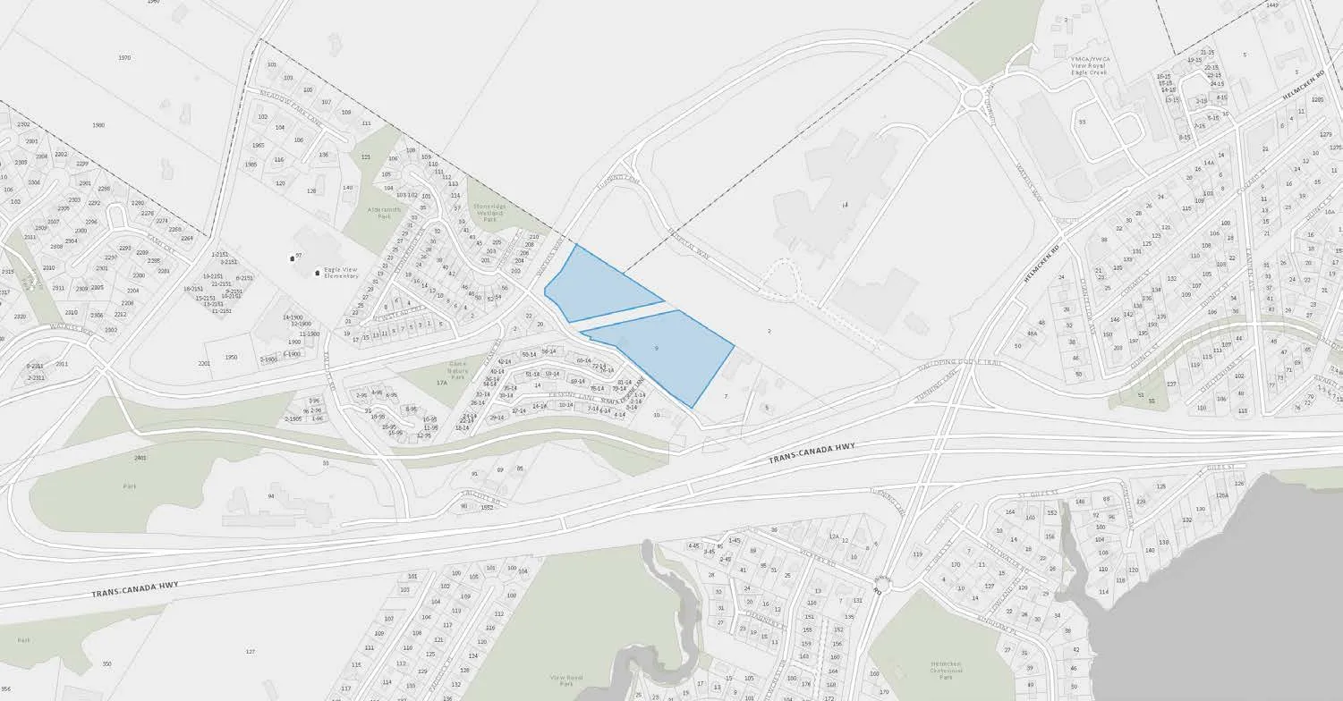
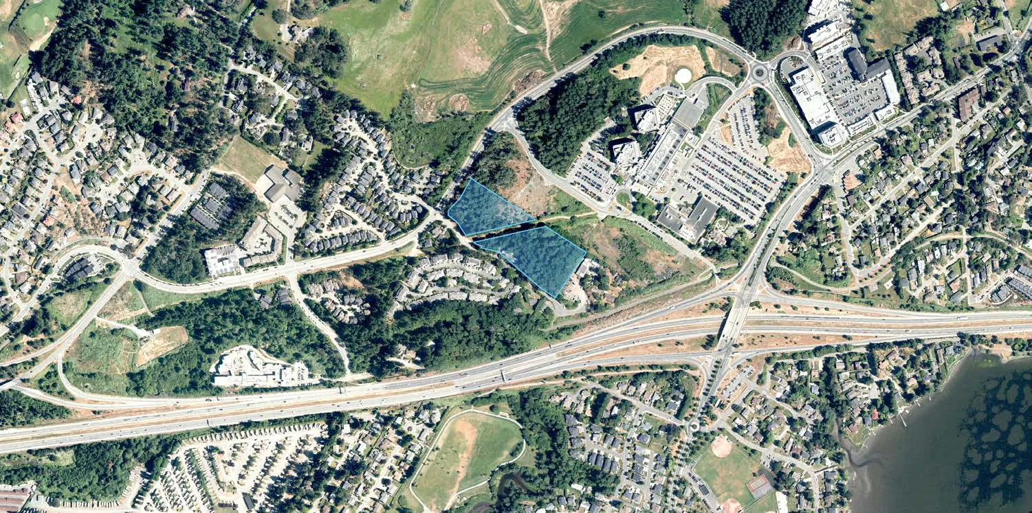
PURPOSE OF REPORT
The purpose of this report is to introduce the Mixed Residential Form and Character Development Permit application for 9 Erskine Lane to Committee.
The property was rezoned to CD-25 Erskine Lane Residential in January of 2021. A Development Agreement and Housing Agreement were part of that rezoning to secure the following:
- $1,176,000 in Community Amenity Contributions
- Construction of a roundabout at the intersection of Watkiss and Erskine Lane
- 100% purpose-built rental
- 10% of the units are Affordable Housing Units (maximum $74,150 household income for units under two bedrooms and maximum $113,040 household income for two or more bedrooms)
- Level 2 charging pre-wiring for every parking space, plus five parking spaces per building with installed wired conduit Level 2 charging stations
- 12 monthly transit passes for one occupant of each dwelling unit
- One carshare vehicle (and parking space) and one bikeshare bicycle per building for at least two years
PROJECT INFORMATION
The application has not changed in any significant way since the rezoning application. Additional information or changes include:
- The façade designs for the building have changed very slightly, mainly to the areas of wood cladding
- More specific site detail in the drawings has been provided
- Planting plan within the landscape plan
- Detailed building height information is included
- A complete summary of how the proposal addresses the Mixed Residential Form and Character Guidelines has been provided by the applicant
VARIANCES REQUESTED
- Variances for height of two of the four buildings (0.73m and 1.43m for buildings A and D, respectively, from the 15.5m permitted)
- Variances to height of retaining walls, tentatively from 1.2m to 1.8m
- Cash in Lieu of parking and/or variances to parking spaces from 436 to 342 spaces provided (note the correction from the report – 342 not 324) which is the same as that mentioned at the time of rezoning.
Proposed Development Statistics
| PROPOSED LOT A | PROPOSED LOT B | |
|---|---|---|
| Lot Size | 8,575m2 | 11,955m2 |
| Floor Area | 12,360m2 | 13,650m2 |
| Density | 1.44 FSR | 1.14 FSR |
| Units/Hectare | 184 | 149 |
| Units/Acre | 75 | 56 |
| Building Heights | 5 storeys | 5 storeys |
| *Site Coverage | 30% | 22% |
| Units Proposed | 158 | 178 |
| Vehicle Parking | 164 | 178 |
Unit Mix
- 16 studio units
- 160 one-bedroom units
- 120 two-bedroom units
- 40 three-bedroom units
CD-25: Erskine Lane Residential
| Lot Size | |
| Lot Size, minimum (Subzone A) | 8,400m2 |
| Lot Size, minimum (Subzone B) | 12,000 m2 |
| Lot Density | |
| Floor Space Ratio (Subzone A) | 1.5 |
| Floor Space Ratio (Subzone B) | 1.15 |
| Lot Coverage | |
| Lot Coverage, Maximum (Subzone A) | 30% |
| Lot Coverage, Maximum (Subzone B) | 22% |
| Impermeable Surface Coverage, Maximum | 40% |
| Size of Principal Buildings and Other Structures | |
| Building Height | 15.5m and 5 storeys |
| Building Width, Maximum | 6m |
| Siting of Buildings and Other Structures (Principal and Accessory) | |
| Northwest Lot Line – Watkiss Way Frontage (Subzone A) | 7.5m |
| Northeast Lot Line (Subzone A) | 7m |
| Southwest Lot Line – Erskine Lane Frontage (Subzone A) | 7.5m |
| South Lot Line – CRD Property Frontage (Subzone A) | 4m |
| North Lot Line – CRD Property Frontage (Subzone B) | 4m |
| Northeast Lot Line (Subzone B) | 7m |
| Southeast Lot Line (Subzone B) | 19m |
| Southwest Lot Line – Erskine Lane Frontage (Subzone B) | 7m |
ISSUES AND ANALYSIS
Design Character
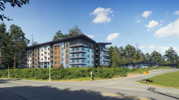
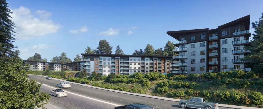
- The design is of the ‘west coast contemporary’ style identified in the Mixed Residential Form and Character guidelines, similar to that of recent developments in the community.
- The proposed materials are dark, natural tones of slate, cedar, concrete, grey and asphalt shingle roofing.
- The strong butterfly roof lines on each building are drawn down into the façade and break the face of the building up into less imposing quadrants. It is a very strong design.
- Decks and windows address all open spaces and accesses on the property and provide ‘eyes on the street’ for residents and visitors.
- Garbage and recycling are located centrally and appropriately screened, with a space for each lot and a dedicated loading space adjacent.
Siting, Height and Massing
The buildings are pulled back from Erskine Lane and do not present a long façade. The façade is broken up extremely effectively with strong roof line elements extending into the façade. Much of the mass of the buildings will be softened by the retained trees on the site.
The proposed siting, height and massing has not changed since the rezoning proposal, but there remains a small disparity in the finished grade compared to the surveyor’s calculated grade (as attached).
Analysis of adjacent 7 Erskine heights will be done in advance of Council.
| Permitted building height | Proposed building height | |
|---|---|---|
| Building A | 15.5 | 16.23* |
| Building B | 15.5 | 14.23 |
| Building C | 15.5 | 11.93 |
| Building D | 15.5 | 16.93* |
Retaining Wall Heights
To support the buildings there are some stacked boulder retaining walls on-site which will measure between 1.3 and 1.8 metres in height. Anything over 1.2m will require a variance; staff will work with the applicant to determine the exact heights of these retaining walls on-site in advance of bringing the file back to Council.
Stacked boulder could be replaced with other options should Council prefer.
Landscaping and Tree Retention
Retaining trees where possible.
The applicant is proposing that 40% of the current tree coverage will be retained and is proposing to plant 178 additional trees on site as per the landscaping plan. This is less than the 250 stated at time of rezoning; the Landscape Architect has indicated that the 178 trees is the most that can be planted on site to maintain tree health and to avoid planting in existing natural areas.
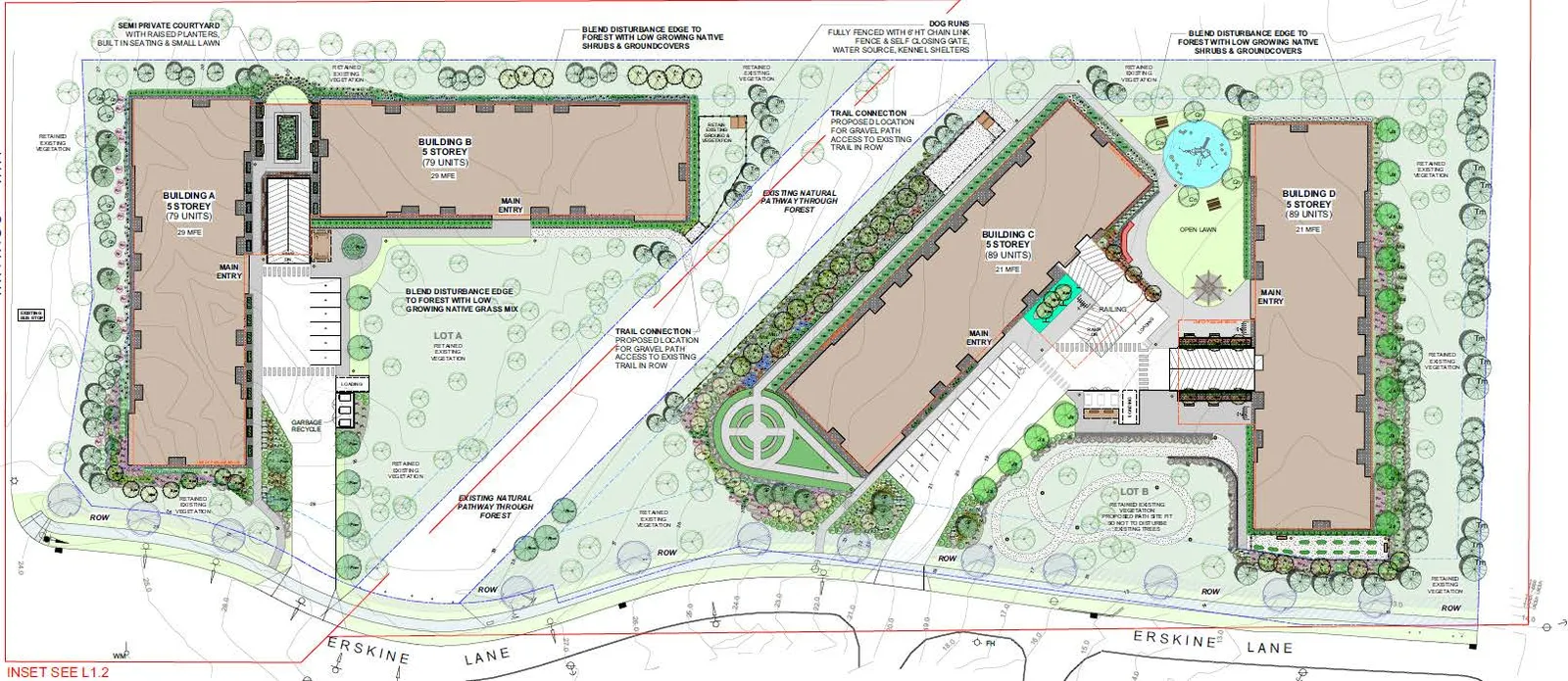
The site will be heavily treed regardless, and the site has a good mix of natural and active open space with included dog runs, a play structure, a section of open lawn for informal gathering and play, small walking path loop, herb garden, and covered bicycle parking.
Landscape Plan
Parking
The applicant has provided the bulk of the parking in underground stalls, with 100% of the proposed vehicle parking on-site having Level 2 charging outlets, and 100% of the proposed secured bicycle parking with Level 1 charging outlets.
There are proposed 6 surface parking spaces for Buildings A and B and 12 surface parking spaces for Buildings C and D. Buildings A and B do not have a proposed accessible parking stall; staff would prefer one, and ideally one per building.
The applicant requires 436 parking spaces and is proposing to supply 342 (324 underground and 18 above ground). The applicant may use cash in lieu of parking provisions in the zoning bylaw for up to 15% of the required parking (65 spaces) but would still need a variance of 29 spaces. This is the same as what was proposed for the rezoning.
A parking variance is not uncommon for purpose-built rental buildings with an affordability component. Staff is supportive of this in the context of affordability. That said, Council can require a parking study to reach a level of confidence with the parking supplied.
Lighting
A lighting plan has not been provided but the applicant’s provided guidelines state LED lighting with a focus on ‘dark skies friendly’ design. Staff will request a lighting plan in advance of the application coming forward to Council.
Access, Circulation
The site is well designed with short-run driveways to the underground parking, easy pedestrian access and surface parking to serve the buildings. The entrances to the buildings face the central parking and common areas with safety and visibility in mind.
Staff would prefer that there were a better balance between the surface parking and accessible parking between Lot A and Lot B. Staff will work with the applicant in that regard.
Stormwater Management
A Stormwater Management Plan must be submitted to the Town’s Engineering Department for review and acceptance prior to the issuance of the Development Permit, as some onsite landscaping elements may contribute to the site’s SWM.
The plan must address all drainage entering and exiting the proposed development to maintain post development flows to predevelopment levels and to incorporate water quality treatment provisions to meet the performance targets specified in the Town’s Storm Water Regulation Bylaw. It must attempt to mimic or recreate the natural, pre-development balance or mix of interception, evapotranspiration, infiltration, and runoff on the development site.
Road Dedication
A strip of property must be dedicated to the Town to achieve the required 18 m wide road right-of-way on Erskine Lane. The width and location of this strip of land is detailed in the attached Servicing Requirements.
CONCLUSION AND NEXT STEPS
Staff is supportive of the application.
Staff will continue to work with the applicant to refine some information provided, including:
- Ways to potentially reduce requested variances
- A lighting plan for the site focusing on dark skies friendly design.
- More even distribution of surface parking between Lot A and Lot B.
- An illustration of the relative building heights between the subject site and the adjacent proposed at 7 Erskine Lane.
- Determine if the site is to be subdivided. If it is, the proposed subdivision needs to be included as part of the consideration of the Development Permit.
RECOMMENDATION
THAT Committee receive the report from the Community Planner entitled “Mixed Residential Form and Character Development Permit 9 Erskine Lane” and dated April 7, 2021 for information.
Document Images
(3)