AMENDMENT Section 3.5 and 3.6 – Flood Hazard Area Land Use Management Guidelines
Attachment 1 to the Sea Level Rise report, containing provincial guideline amendments for managing land use in coastal flood hazard areas.
AMENDMENT: Section 3.5 and 3.6 – Flood Hazard Area Land Use Management Guidelines
3.5 The Sea
3.5.1 Background and Reference Documents
The content for this Amendment is drawn primarily from, “Climate Change Adaptation Guidelines for Sea Dikes and Coastal Flood Hazard Land Use – Guidelines for Management of Coastal Flood Hazard Land Use”, Ausenco Sandwell, report to BC Ministry of Environment, January 27, 2011 (AS (2011b)) and the companion reports, “Sea Dike Guidelines” and “Draft Policy Discussion Paper”, also dated January 27, 2011.
These 2011 reports, including terminology, definitions and explanatory figures, supplement this Amendment to the “Flood Hazard Area Land Use Management Guidelines”. Definitions for the terms used in this Amendment are provided in Appendix A of AS (2011b). Where there is any inconsistency between the Ausenco Sandwell (2011) reports and this Amendment document, the Amendment document shall govern. These reports are referenced in this Amendment as:
“Draft Policy Discussion Paper” - AS(2011a) “Guidelines for Management of Coastal Flood Hazard Land Use” - AS (2011b) “Sea Dike Guidelines” - AS (2011c)
These reports are available on the ministry web page: http://www.env.gov.bc.ca/wsd/public_safety/flood/fhm-2012/draw_report.html
The definition of and method(s) of determination of Flood Construction Level (FCL) for coastal areas has been modified for the purposes of this Amendment (also see definitions in AS 2011b). The FCL is used to establish the elevation of the underside of a wooden floor system or top of concrete slab for habitable buildings, but does not relate to the crest level of a sea dike.
The management of land use in coastal flood hazards may require flood hazard assessments to be completed by suitably qualified Professional Engineers, experienced in coastal engineering. The standards of practice that these Professionals should follow include those outlined in the most recent revision of the “Professional Practice Guidelines – Legislated Flood Assessments in a Changing Climate in BC”, first published by the Association of Professional Engineers and Geoscientists of BC (APEGBC) in 2012.
The APEGBC Professional Practice Guidelines describe and provide for use of risk assessment methodologies, however, this Amendment does not consider how risk based approaches might be incorporated into sea level rise area planning, determination of setbacks and FCLs, or long term flood protection strategies. Should local governments, land use managers and approving officers choose to base approval decisions on risk assessments prepared by Professional Engineers, the changes in risk over time due to sea level rise must be fully taken into account.
3.5.2 Design and Planning Time Frame
Requirements for buildings, subdivision, and zoning should allow for sea level rise (SLR) to the year 2100.
Land use adaptation strategies as set out in Official Community Plans (OCPs) and Regional Growth Strategies (RGSs) should allow for sea level rise to the year 2200 and beyond.
3.5.3 Recommended Sea Level Rise Scenario for BC
Allow for Global Sea Level Rise of 0.5 m by 2050, 1.0 m by 2100 and 2.0 m by 2200 relative to the year 2000 as per Figure 1.
Adjust for regional uplift and subsidence using the most recent and best information available. Where no information is available, assume neutral conditions (i.e. no uplift or subsidence).
The scenario in Figure 1 is intended to be reviewed every 10 years or sooner if there is significant new scientific information.
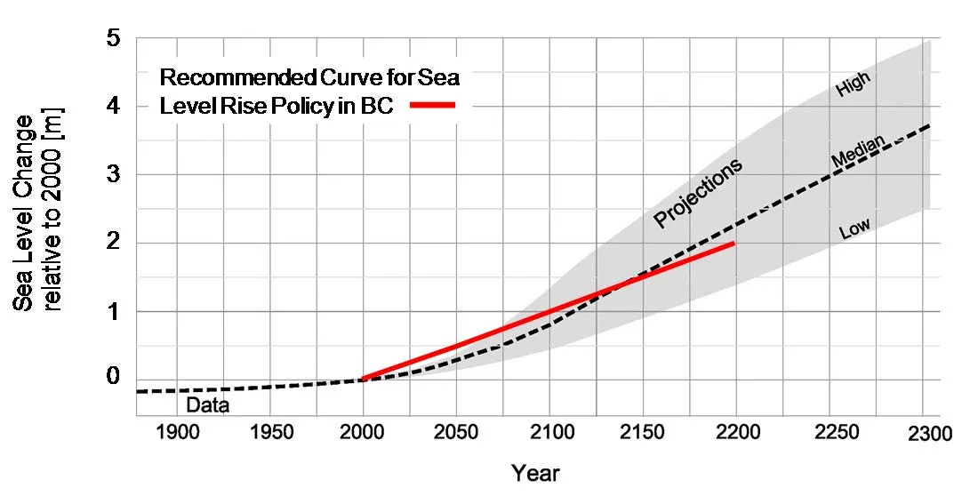
Figure 1. Recommended Global Sea Level Rise Curve for Planning and Design in BC
3.5.4 Sea Level Rise Planning Areas
Local Governments should consider defining SLR Planning Areas and developing land use planning strategies integrating both flood protection (sea dikes) and flood hazard management tools. These areas should include areas exposed to coastal flood hazards, diked areas and inland floodplains adjacent to tidally influenced rivers where potential flood levels will be increased by sea level rise.
As one possible management tool, lands included within SLR Planning areas may be designated by local governments as floodplains under Section 524 of the Local Government Act and if land is so designated, local governments may, by bylaw, specify flood levels and setbacks to address sea level rise.
3.5.5 Strait of Georgia - Areas Not Subject to Significant Tsunami Hazard¹
3.5.5.1 Standard FCLs and Setbacks
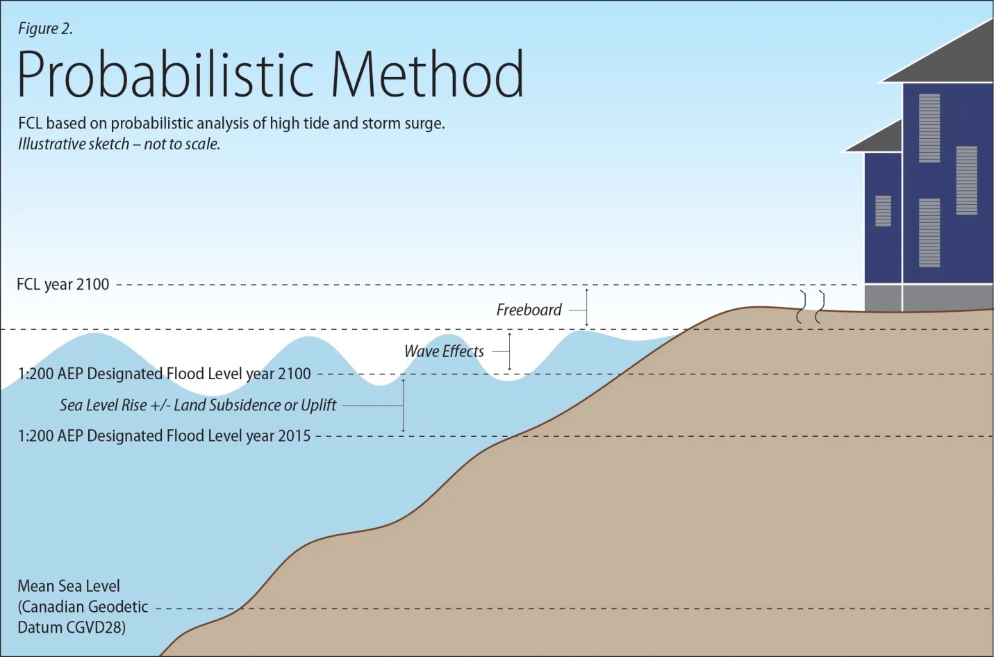
The Year 2100 FCL should be established for specific coastal areas by a suitably qualified Professional Engineer, experienced in coastal engineering. This work could be completed as part of regional floodplain mapping, SLR Planning Area studies, or as part of development approval processes. The Year 2100 FCL should be the minimum elevation for the underside of a wooden floor system or top of concrete slab for habitable buildings, and should be determined (see Figure 2) as the sum of:
- The 1:200, or 1:500² Annual Exceedance Probability (AEP) total water level as determined by probabilistic analyses³ of tides and storm surge;
- Allowance for future SLR to the year 2100;
- Allowance for regional uplift, or subsidence to the year 2100;
- Estimated wave effects associated with the Designated Storm with an AEP of 1:200, or 1:500; and
- A minimum freeboard of 0.6 metres.
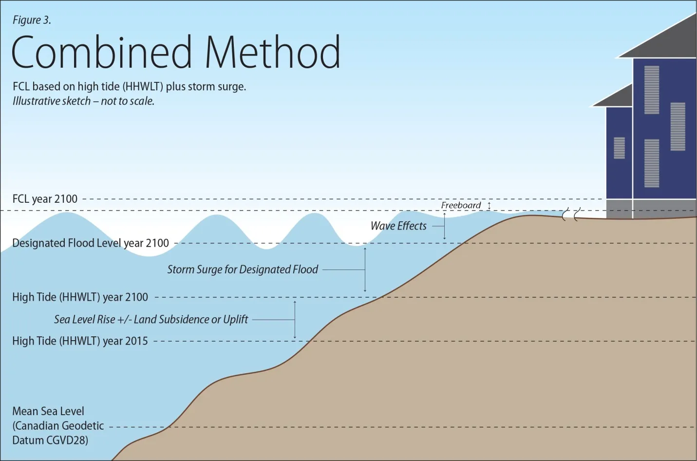
Alternatively, the Year 2100 FCL can be determined by a more conservative “Combined Method” as described in the Ausenco Sandwell (2011) reports (see Figure 3). Example calculations of FCLs for specific areas in coastal BC are provided in Table 3-2 AS(2011b) where the FCL is determined as the sum of:
- Allowance for future SLR to the year 2100;
- Allowance for regional uplift, or subsidence to the year 2100;
- Higher high water large tide (HHWLT);
- Estimated storm surge for the Designated Storm with an AEP of 1:200, or 1:500 as per Table 6-1 in AS(2011a);
- Estimated wave effects associated with the Designated Storm; and
- A minimum freeboard of 0.3 metres.⁴
¹ Refers to “Zone E” as shown on the “Tsunami Notification Zones for BC” map published by Emergency Management BC, November, 2015 and includes the Strait of Georgia, Gulf Islands, Greater Vancouver, Johnstone Strait but not including the east side of the Saanich Peninsula and Greater Victoria.
² While a 1:200 AEP is the minimum provincial standard, local governments may decide to adopt more stringent criteria for heavily populated and built-up areas.
³ Because of the variation along the BC Coast in the availability of reliable long term water level gauge data and site specific effects including uplift, subsidence and wave effects, the decision on selection of an appropriate methodology to determine the FCL is up to the local government jurisdiction based on recommendations from a suitably qualified Professional Engineer, experienced in coastal engineering. Where studies are required to determine sea dike design levels, the design level analyses and dike design must be reviewed and approved by the Inspector, or Deputy Inspector of Dikes, as part of the Dike Maintenance Act approval process.
⁴ Given that the “Combined Method” provides conservative values for Year 2100 Designated Flood Levels (because the method assumes the Designated Storm occurs in conjunction with a high tide) the freeboard may be reduced from 0.6 m to 0.3 m for this method for situations where the full FCL may be difficult to achieve.
The building setback should be at least the greater of 15 m from the future estimated Natural Boundary of the sea at Year 2100, or landward of the location where the natural ground elevation contour is equivalent to the Year 2100 FCL (refer to Figure 2-2 in AS (2011b) for a definition sketch – except that the Year 2100 Designated Flood Level and future FCL as shown in this sketch can be determined by either probabilistic analyses, or the “Combined Method”).
Where the sea frontage is protected from erosion by a natural bedrock formation, the development approving official may agree to modify setback requirements as recommended by a suitably qualified Professional Engineer experienced in coastal engineering. The Professional Engineer should fully consider all aspects of the coastal flood hazard associated with Year 2100 water levels including potential wave, debris and related splash impacts on buildings. This approval should be augmented through a restrictive covenant describing the hazard and building requirements, and including the Professional Engineer’s report and a liability disclaimer.
The setback may be increased on a site-specific basis such as for exposed erodible beaches and/or in areas of known erosion hazard.
3.5.5.2 Subdivision
All lots created through subdivision should have viable building sites on natural ground that is above the Year 2100 FCL and comply with the setback guidelines noted above.
To regulate redevelopment at the end of the building lifespan, the development approving officer should require a restrictive covenant stipulating that any future reconstruction must meet the FCL and setbacks requirements in force at the time of redevelopment.
Subdivision may be approved within a Sea Level Rise Planning Area in areas where the natural ground is lower than the Year 2100 FCL where the local government has developed and adopted a long term flood protection strategy completed by a suitably qualified Professional Engineer experienced in coastal engineering and referencing applicable professional practice (APEGBC) and provincial guidelines available at the time. The strategy should incorporate mitigation to address all relevant risks including flood risk due to sea level rise to the year 2200 and beyond⁵ and is to be comprised of both raising of ground elevations with fill and adequate provisions for future dike protection, including sufficient land and/or rights of way for the future dike (also see Appendix 1).
Subdivision may also be approved in areas where the natural ground is lower than the Year 2100 FCL where all of the following conditions have been met:
- The subdivision development involves a maximum of 2 lots;
- The site is located on the coastal floodplain fringe adjacent to high ground;
- The building site ground elevations have been raised to the Year 2100 FCL and the fill extends to and is contiguous with natural ground above the Year 2100 FCL;
- The fill is adequately protected from the sea by erosion protection works, with consideration of wave impacts associated with Year 2100 sea levels;
- The building setbacks comply with the setback guidelines noted above;
- A suitably qualified Professional Engineer, with experience in coastal engineering has prepared a detailed design for the fill and erosion protection works including a report considering all of the above and has concluded that the site may be suitable for the use intended;
- The Professional Engineers’ report forms part of the restrictive covenant registered on the title of each lot; and
- The restrictive covenant registered on title stipulates that the landowners are responsible for maintenance of the erosion protection works on their own land.
⁵ The long term flood protection strategy should be reviewed and updated as necessary every 10 years, or as a change to an OCP or RGS warrants. Updates should continue to consider flood risks a minimum of 100 years in the future.
3.5.5.3 Development on Existing Lots
Standard setbacks and elevations apply. To regulate redevelopment at the end of the building lifespan, the development approving official should require a restrictive covenant stipulating that any future reconstruction must meet the FCL and setbacks requirements in force at the time of redevelopment.
On existing lots, if meeting the setback guidelines noted above would sterilize the lot (i.e., not allow even one of the land uses or structures permitted under the current zoning), the development approving official may agree to modify setback requirements as recommended by a suitably qualified Professional Engineer experienced in coastal engineering, provided that this is augmented through a restrictive covenant stipulating the hazard, building requirements, and liability disclaimer.
The Year 2100 FCL requirements would still apply to new habitable building construction.
3.5.5.4 Lots with Coastal Bluffs
For lots containing coastal bluffs that are steeper than 3(H):1(V) and susceptible to erosion from the sea, setbacks should be determined as follows:
- If the future estimated Natural Boundary is located at least 15 m seaward of the toe of the bluff, then no action is required and the setback should conform with other guidelines that adequately address terrestrial cliff and slope stability hazards.
- If the future estimated Natural Boundary is located 15m or less seaward of the toe of the bluff, then the setback from the future estimated Natural Boundary should be located at a horizontal distance of at least 3 times the height of the bluff, measured from 15 m landwards from the location of the future estimated Natural Boundary.
In some conditions, setbacks may require site-specific interpretation and could result in the use of a minimum distance measured back from the crest of the bluff. The setback may be modified provided the modification is supported by a report, giving consideration to the coastal erosion that may occur over the life of the project, prepared by a suitably qualified Professional Engineer experienced in coastal engineering.
3.5.6 Outside the Strait of Georgia Area - Areas Subject to Significant Tsunami Hazard⁶
Tsunami setbacks and elevations should be required for new lots created through the subdivision approval process. Tsunami hazard requirements and regulations for existing lots may be determined by local governments on a site specific or regional basis.
The “standard” setbacks and elevations in sections 3.5.5.1 to 3.5.5.4 above apply to all coastal areas outside of the Strait of Georgia, except for new subdivisions subject to significant tsunami hazards, in which case the tsunami setbacks and elevations shall apply. Where the tsunami hazard is low, the greater FCLs and setbacks shall apply.
A subdivision application in a tsunami prone area must include a report by a suitably qualified Professional Engineer, experienced in coastal engineering who must formulate safe building conditions for each proposed lot based on a review of recent Tsunami hazard literature including the report, “Modelling of Potential Tsunami Inundation Limits and Run-Up”, by AECOM for the Capital Regional District, dated June 14, 2013, plus the historical report, “Evaluation of Tsunami Levels Along the British Columbia Coast”, by Seaconsult Marine Research Ltd., dated March 1988.
At a minimum, building conditions should protect improvements from damage from a tsunami of equal magnitude to the March 28, 1964 tsunami that resulted from the Prince William Sound, Alaska earthquake and a possible Cascadia Subduction Zone earthquake.
Setback – Setback requirements should be established on a site-specific basis and take into account tsunami hazards.
The setback must be sufficient to protect buildings and must be at least 30 metres from the Year 2100 estimated natural boundary.
FCL – FCL requirements should be established on a site-specific basis and take into account tsunami hazards.
Reductions to these requirements should only be considered where the building can be built to the Tsunami FCL on bedrock.
⁶ Refers to “Zones A, B, C and D” as shown on the “Tsunami Notification Zones for BC” map published by Emergency Management BC, November, 2015 and includes the North Coast, Central Coast, and Juan de Fuca Strait including Greater Victoria and the east side of the Saanich Peninsula.
3.6 Areas Protected by Dikes
Residential, commercial and institutional developments in areas protected by dikes are required to comply with full flood proofing requirements for their respective categories, with a possible exception for development within Sea Level Rise Planning Areas as noted below.
Setback – Buildings should be located a minimum of 7.5 metres away from any structure for flood protection or seepage control or any dike right-of-way used for protection works. In addition, fill for floodproofing should not be placed within 7.5 metres of the inboard toe of any structure for flood protection or seepage control or the inboard side of any dike right of-way used for protection works, unless approved by the Inspector of Dikes as part of a dike upgrading plan.
Additional dike right of way and building set back requirements should be defined for Sea Level Rise Planning Areas to accommodate the widening and raising of dikes for sea level rise.
Any change to these conditions requires the approval of the Inspector of Dikes.
FCL – Buildings and manufactured homes in areas protected by dikes should meet minimum FCLs prescribed for the primary stream, lake or sea adjacent to the dike and the FCL requirements for any internal drainage (minimum ponding elevations). FCLs for diked coastal areas may also be determined through a comprehensive, site-specific dike breach modeling study, completed by a suitably qualified Professional Engineer, and based on a minimum 1:200 AEP sea water level in the Year 2100, inclusion of a minimum 0.6 m freeboard above modelled water levels and conservative modelling assumptions.
Relaxation of FCL requirements for new development in coastal areas protected by dikes may be appropriate for Sea Level Rise Planning Areas where the local government has developed and adopted a long term flood protection strategy completed by a suitably qualified Professional Engineer experienced in coastal engineering and referencing applicable professional practice (APEGBC) and provincial guidelines available at the time (see Appendix 1). This relaxation should be augmented through a restrictive covenant stipulating the hazard and protection strategy, building requirements, and liability disclaimer.
3.6.1 Secondary sources of flooding
Where there are secondary sources of flooding within diked areas, the appropriate requirements as set out in Clauses 3.1 through 3.5 should be applied. These should include consideration of minimum ponding elevations behind the dike to protect against internal drainage.
Amended: October 1, 2016
APPENDIX 1 – LONG TERM FLOOD PROTECTION STRATEGY
Section 3.6 states that “Relaxation of FCL requirements for new development in coastal areas protected by dikes may be appropriate for Sea Level Rise Planning Areas where the local government has developed and adopted a long term flood protection strategy completed by a suitably qualified Professional Engineer experienced in coastal engineering and referencing applicable professional practice (APEGBC) and provincial guidelines available at the time.” Similarly section 3.5.2 provides for subdivision approvals in low lying coastal floodplain areas where the local government has developed a long term flood protection strategy. This appendix outlines the steps involved in developing a long-term flood protection strategy and the issues that should be addressed at the various stages of development of the strategy.
1. General
- Relaxation of FCL requirements for new development in the protected area and intensification of development through subdivision of land has significant long term implications. The future reliance on the sea dikes and consequences of dike failure will increase as development occurs and sea level rises. Therefore, the extent of work required to establish a successful long term dike upgrading program is demanding and costly. This approach should only be undertaken where the extent of community development in the floodplain justifies the high cost and level of effort.
- While additional site specific factors and flood hazards may be relevant for specific areas, the criteria and work outlined herein must generally be completed to justify relaxation of requirements.
2. Feasibility Study
The objective of the feasibility study is to help select a conceptual design option or options and to support a decision to proceed with preliminary design for Phase 1. The feasibility study should include the following steps:
- Collect background data and assess information needs including:
- Wind and wave
- Geotechnical (including seismic)
- Land ownership/rights of way
- Long term subsidence information for the site/area
- Environmental
- Proximity and availability of construction materials
- Review regulations and permits required
- Define design parameters
- Dike safety standards and guidelines
- Decision on minimum Annual Exceedance Probability (AEP) of design water level
- Sea level rise scenario(s) and planning horizons (i.e. year 2100 and 2200) based on the Recommended Sea Level Rise Planning Curve presented in Figure 1.
- Develop options and complete conceptual designs. Design options may include:
- Offshore breakwater, erosion protection and various overtopping designs
- Wide landfills (i.e.“superdike”concept)
- Conventional earth dike (minimal use of floodwall closure sections)
- Sea barrier/tide gate
- other
- Assess adaptability of option for very long term upgrading (i.e. year 2200)
- Assess environmental impact of options
- Assess social impact of options
- Develop cost estimates
- Develop recommendations for detailed engineering and environmental studies
- Prepare draft report
- Define key stakeholders and engage to get feedback
- Complete public consultation process
- Compare alternatives with respect to cost/ social acceptance/environment
- Develop draft short term and long term implementation plans
- Prepare final report
- Present to local government council/board and funding agencies (Province) for approval in principle
3. Preliminary Design for Phase 1
Preliminary design for a Phase 1 of the flood protection program is required to support funding commitments.⁷ The Phase 1 project scope would typically include at least 25% of the dike upgrading work required to meet the year 2100 flood protection requirements.
- Complete detailed engineering studies as recommended by the feasibility study (such as geotechnical, land acquisition, environmental etc.):
- Phasing should be planned so that the minimum design AEP is maintained or exceeded at all times, considering up to date SLR curve information.
- Complete preliminary design for Phase 1
- Prepare detailed cost estimates to support funding commitments by both local and senior governments
- Before any design work is initiated, local governments are encouraged to contact the regional Deputy Inspector of Dikes to discuss proposed design projects.
4. Long Term Flood Protection Strategy
- Outline construction phasing plan – while work can proceed incrementally, preliminary designs and major components (i.e. land assembly) should be completed in no more than 4 phases by 2100. (As previously noted, phasing should be planned so that the minimum design AEP is maintained or exceeded at all times, considering up to date SLR curve information.)
- Land Ownership and Legal Access – confirm detailed plans to acquire lands for at least Phase 1 as a minimum, and a strategy to acquire lands for Phases 2, 3 and 4 (if needed).
- Dike Operation and Maintenance – prepare detailed operation and maintenance plan.
- Dike Maintenance Act (DMA) Approval for Phase 1 – apply for and obtain approval from the regional Deputy Inspector of Dikes
- Financial Plan – confirm funding approval in place for Phase 1 through established cost share programs. Confirm political commitment by both local and senior governments to long term support for the Flood Protection Strategy.
⁷ Where subdivision development is being contemplated in areas where the natural ground is lower than the Year 2100 FCL, the long term flood protection strategy is to be comprised of both raising of ground elevations with fill and adequate provisions for future dike protection. Phasing of land filling and dike construction would be established on a site specific basis.
5. Governance
Local governments may wish to establish appropriate governance or committees to provide direction, technical input, and public consultation throughout the process. The province may participate in an advisory capacity, providing guidance and information on provincial policies, standards, regulations and design criteria. The province’s participation does not guarantee approval of applications required under the Dike Maintenance Act. Applications will be assessed on their own merit and the decision maker will consider the application within the context of the long term strategy.