Presentation: Sea Level Rise Update - 2020 CRD Coastal Flood Inundation Mapping Project
A presentation providing an update on local Sea Level Rise initiatives, regional mapping results, and implications for town policy.
Sea Level Rise Update
2020 CRD Coastal Flood Inundation Mapping Project
PURPOSE:
To provide an update on local Sea Level Rise initiatives prior to commencing a Sea Level Rise and storm surge mitigation and adaptation policy.
BACKGROUND:
- 2015 CRD Coastal Sea Level Rise Risk Assessment report on potential economic impacts on key public infrastructure and private assets in 24 focus areas including Portage Inlet. It found different levels of inundation may occur across the CRD because of varying topography, with principal impacts on network infrastructure for water and wastewater, and some road bridges.
- 2018 amendment to the 2004 Provincial Flood Hazard Area Land Use Management Guidelines to consider 1.0 m sea level rise by 2100 (an 2.0m by 2200) for establishing:
- Flood Construction Levels
- Flood Setbacks
- Sea Level Rise and storm surge mitigation and adaptation policy is identified in the Strategic Plan.
DISCUSSION:
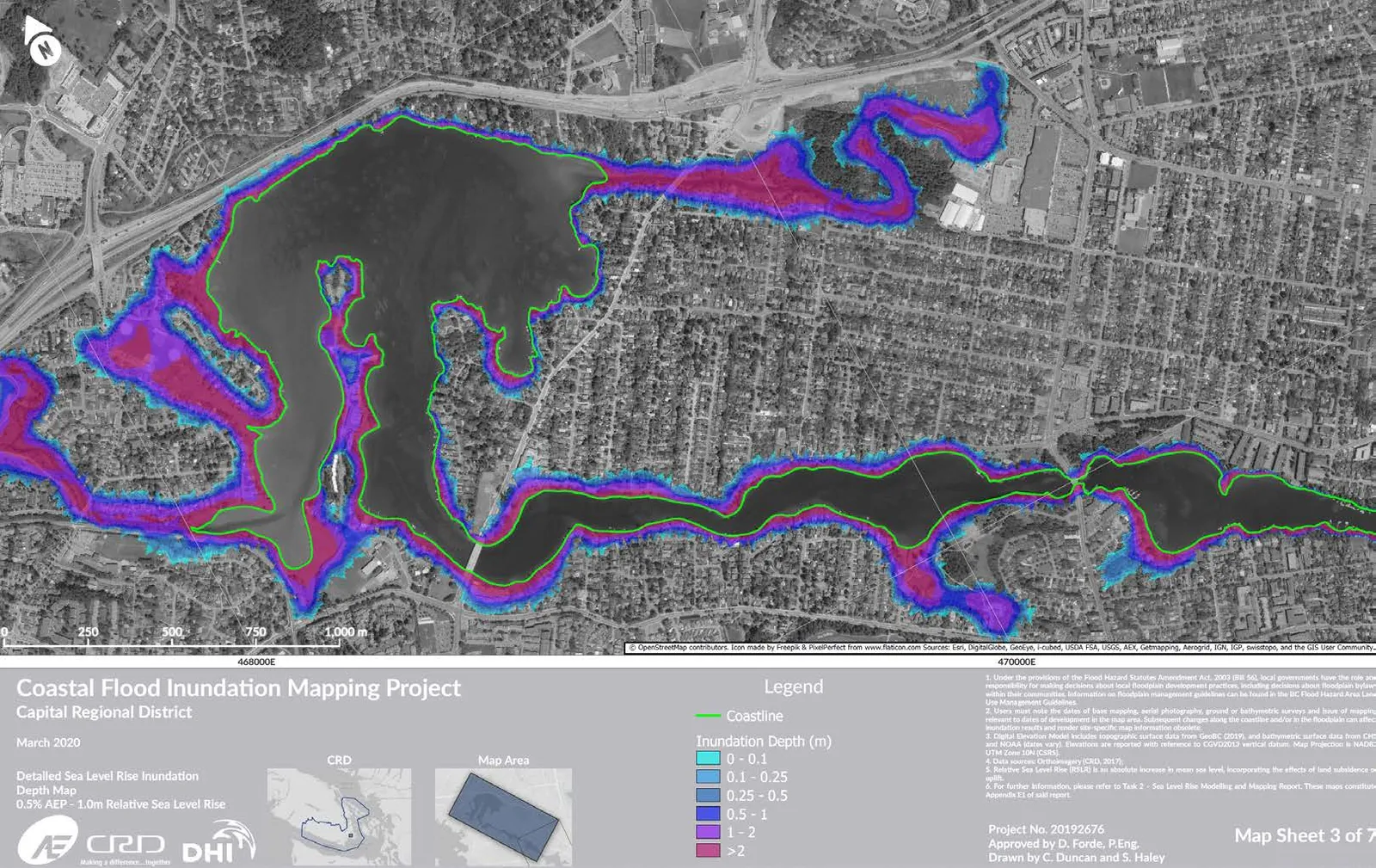
- 2020 CRD Coastal Flood Inundation Mapping Project
- Implications for the Town
- Regional response
- Next steps
1. 2020 CRD Coastal Flood Inundation Mapping Project
- Methodology involved dividing the shorelines into reaches, examining a sample transect within in each reach to
- project the extent of inundation
- mapping the potential extent under different scenarios (including tsunami risk)
- estimate general Flood Construction Levels
- There are differing professional interpretations of the methodology from the APEGBC Professional Practice Guidelines and staff is continuing to monitor this discussion of the underlying assumptions.
2. Implications for the Town
The full report estimates Flood Construction Levels along Esquimalt Harbour and Portage Inlet under different Sea Level Rise scenarios:
- no change
- 0.5m (Year 2050)
- 1.0m (Year 2100)
- 2.0m (Year 2200)
Long term impacts to a specific property will depend on physical shoreline characteristics, proximity to the sea edge, and elevation above sea level:
- Low-lying properties close to the sea may be subject to temporary (tidal) or permanent inundation.
- Properties on coastal bluffs may be subject to impacts from erosion
- Properties set back from the sea may be subject to effects from wind and waves
Issues to consider in policy
| Issue | Considerations |
|---|---|
| Flood Construction Level | How to address height variance requests when Flood Construction Levels result in challenges for compliance with Zoning Bylaw requirements. |
| Setbacks | How to address setback variance requests when Flood Setbacks result in challenges to site a building in accordance with Zoning Bylaw requirements. |
| Soil Deposit | How to address potential demand to alter or raise the grades in yards that could be affected by Sea Level Rise. |
| Development Permit Area guidelines | • Including Sea Level Rise and storm surge considerations for land along the shoreline. • Consider a guideline to replace existing sea walls and other hard armoring with natural restoration. |
| Existing Town infrastructure | Mitigation strategy for existing roads, parks, servicing, and other infrastructure vulnerable to Sea Level Rise and storm surge impacts. |
In the interim, the CRD report is a valuable reference for
- assessing subdivisions and building permits near the shore
- planning new infrastructure
3. Regional Responses
| Municipality | Response |
|---|---|
| Victoria | considering a policy for a Flood Construction Level. |
| Colwood | commissioned a more in-depth and site-specific study to consider a Flood Construction Level policy that considers both Sea Level Rise and tsunami risk. The report is expected to be published in a few months. |
| North Saanich | considered development permit areas before recently pivoting towards marine area Official Community Plan amendments and a Coastal Flooding Mitigation Bylaw – currently on hold while the CRD report is examined. |
| Esquimalt | currently following the Town practice, using the CRD report as a reference for development applications. |
4. Next Steps
- The CRD Coastal Flood Inundation Mapping Project will be a key reference for the Sea Level Rise and storm surge mitigation and adaptation policy.
- Staff proposes to follow up with options for policy development.
- At that time, staff can provide another update if any further information is received from the CRD Coastal Flood Inundation Mapping Project and if the Colwood report is available as an example of a comprehensive approach.
RECOMMENDATION:
THAT the April 7, 2021 report from the Senior Planner titled “Sea Level Rise Update - 2020 CRD Coastal Flood Inundation Mapping Project” be received for information.
Document Images
(1)