ENVIRONMENTAL DEVELOPMENT PERMIT NO. 2021/11 - NATURAL WATERCOURSE AND SHORELINE WITH VARIANCES - 315 STEWART AVE
A staff report evaluation for an application to construct new stacked boulder retaining walls, a patio, and a reconstructed pathway within a Development Permit Area.
TOWN OF VIEW ROYAL COMMITTEE OF THE WHOLE REPORT
TO: Committee DATE: June 3, 2021 FROM: J. Davison, MCIP RPP, Community Planner MEETING DATE: June 8, 2021 FILE NO.: 3060-20-2021-11
ENVIRONMENTAL DEVELOPMENT PERMIT NO. 2021/11 - NATURAL WATERCOURSE AND SHORELINE WITH VARIANCES - 315 STEWART AVE
RECOMMENDATION
THAT the report dated June 3, 2021 from the Community Planner titled “Environmental Development Permit No. 2021/11 – Natural Watercourse and Shoreline with Variances – 315 Stewart Avenue” be received for information.
CHIEF ADMINISTRATIVE OFFICER’S COMMENTS
I concur with the recommendation.
DIRECTOR OF DEVELOPMENT SERVICES’ COMMENTS
I concur with the recommendation.
PURPOSE OF REPORT
The purpose of this report is to introduce a new application for an Environmental Development Permit with variance to permit the construction of retaining walls within the Development Permit Area.
BACKGROUND
The property is 758m² and zoned R-1: Detached Residential (Large Lot). There is no dwelling on the property now, but one is planned. The property has a dock that was regularized as part of the 2012 process to document existing docks along the Esquimalt Harbour shorelines.
The owner wishes to address improvements in the Development Permit Area as it will be difficult to access after the house is built. The property is immediately adjacent to Esquimalt Harbour.
PROJECT INFORMATION
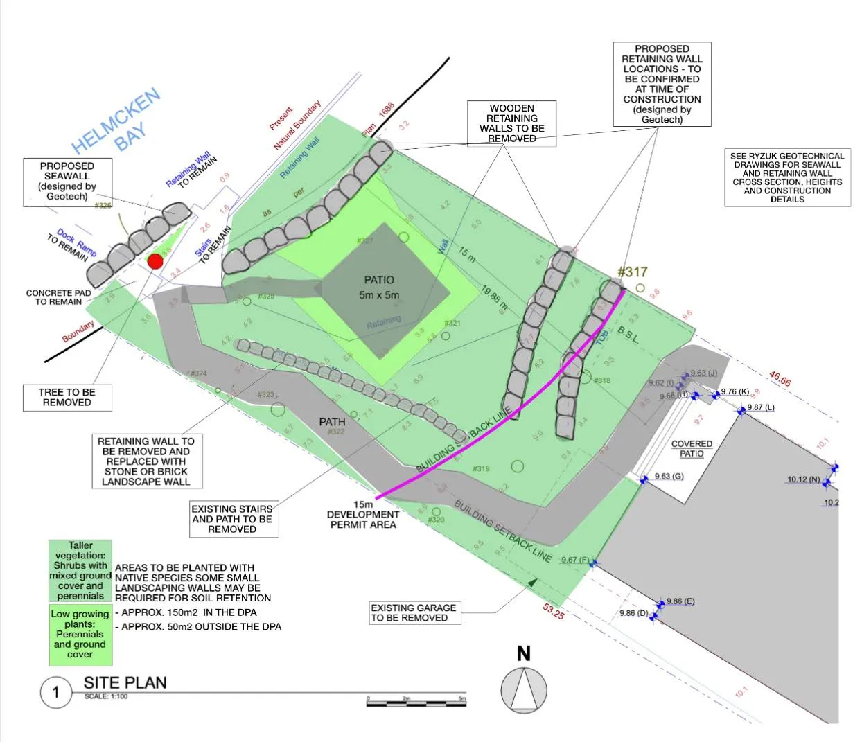
The applicant has made application to construct new stacked boulder retaining walls in the DP Area, along with a 5m x 5m patio area and a reconstruction of the pathway. The applicant has provided the following in support of their application:
- Site Survey – Summit Land Surveying – January 28, 2021
- Landscaping Plan – applicant - undated
- Geotechnical Plans and Report – Ryzuk Geotechnical – April 29, 2021
- Environmental Report – Swell Environmental – May 21, 2021
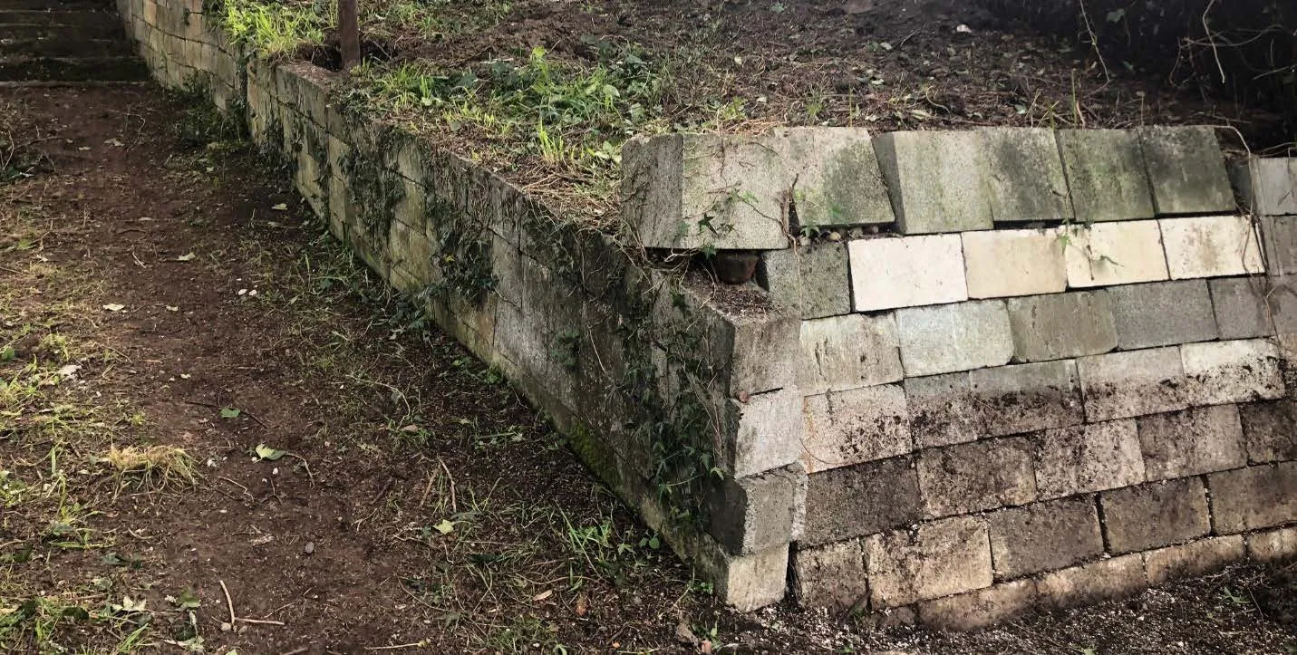
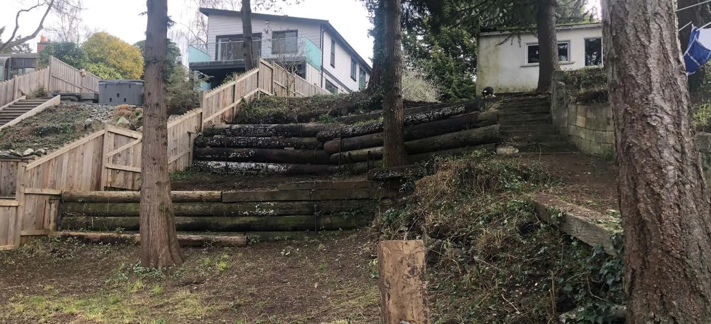
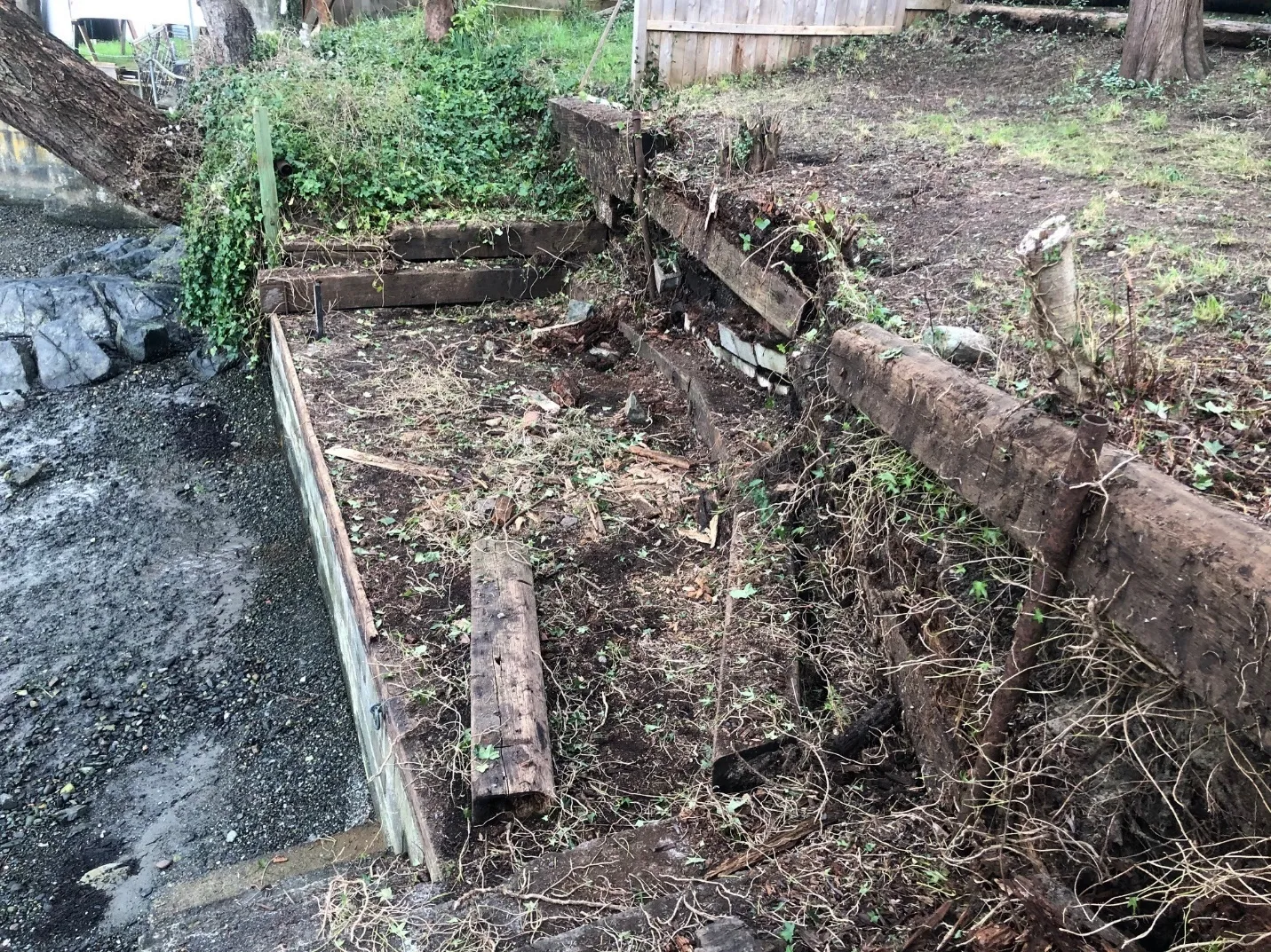
The site, being previously heavily disturbed and largely cleared of invasive species, is in a poor state of maintenance.
Proposal
The applicant’s Environmental Assessment offers the following proposal list for the site:
- Removal of existing creosote wood seawall and retaining walls, upper concrete pathway and stairs, and brick retaining wall
- Removal of invasive species will be conducted during removal of the wall materials
- Installation of a stacked boulder seawall, designed by Ryzuk Geotechnical, above the Present Natural Boundary
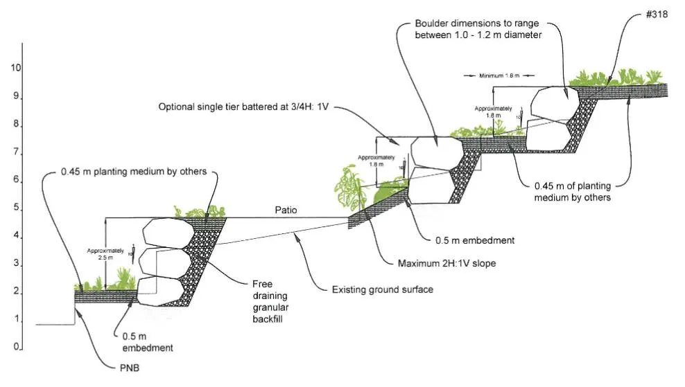
- Installation of 3 stacked boulder walls, designed by Ryzuk Geotechnical, on the slope in the DPA
- Path, Patio, Landscape wall, Invasive Species Removal, and Native Plantings Control invasive species in the DPA
- Retain all trees, except the one noted below
- Install path to replace existing shoreline access and 5m x 5m patio
- Replace existing brick wall with brick or stone wall landscape wall
- Plant the DPA area with native plants to meet the DP Guideline=approx..150m2
- DP Guideline: For shoreline areas heavily impacted by previous development, target the restoration of ecologically appropriate vegetation for an average 15m wide (minimum 5m) shoreline zone over 50% of the shore length.
- Additional approx..50m2 of native plantings outside, but adjacent to the DPA
- Removal of 1 Douglas fir tree for the seawall removal and construction
- 2 replacement Douglas-fir trees to be planted under the direction of the arborist
Requested Variances
The application requires the following variances:
- A variance to Section 3.8.2 of Zoning Bylaw No. 900, 2014 for the construction of retaining walls within the 15m setback to the natural boundary to the sea.
- A variance to Section 4.8.9 of Zoning Bylaw No. 900, 2014 for the height of a retaining wall in a residential zone from 1.2m to 2.5m.
Landscape Design
The applicant has included a 5m x 5m patio within the DP area – it appears that the 2.5m retaining wall has been constructed to allow for the construction of the patio area. It is likely that two smaller retaining walls could be built and the property could be tiered more evenly down the slope. This would, of course, remove some utility for the homeowner and would likely not improve the ecological condition of the property.
Staff would recommend that the patio and pathway be constructed with permeable pavers or other similar material to minimize stormwater runoff and encourage infiltration.
Geotechnical
The geotechnical report recommends the replacement of the existing retaining structures with those proposed, including three significant uplands retaining walls (two at 1.8m high and one at 2.5m high), a proposed seawall and a smaller landscape wall adjacent to the proposed path.
Environment
The Environmental Assessment from Swell Environmental concludes that it is not expected to cause negative impacts to the Development Permit Area:
The works within the DPA have been designed to address the slope stability issues identified by Ryzuk Geotechnical on the site. Provided the Environmental Protection Measures described are followed, I expect the proposed construction activities to have minimal negative impacts to the current ecological condition of the ecosystems of the 15m DPA setback or the marine environment. The restoration activities (invasive species removal and native plantings) will provide improvement over the current ecological conditions for the backshore ecosystem.
CFB Esquimalt
CFB Esquimalt will issue a License of Occupation for any foreshore structures after Town approval of the Development Permit.
DISCUSSION
There are two issues for Council to consider:
- The impact of the proposal on the environment.
- The impact of the variance on the use and enjoyment of adjacent properties.
Impact on Environment
While the Environmental Assessments have made it clear that the impact of the proposed development will not have negative impacts on the environment, the Town’s Official Community Plan is quite clear on the Town’s desire to maintain a natural state within the Natural Watercourse and Shoreline Environmental Development Permit Areas:
Riparian areas and shorelines are important for their ecological value and contribution to the physical and cultural identity of View Royal. These areas support a rich diversity of flora and fauna and are integral elements of greater local and regional environmental systems. Unnecessarily disturbing these sensitive environments may harm their vitality and the ecological services they provide. This Development Permit Area has been established to ensure that the ecological value of sensitive watercourse and shoreline areas have been considered prior to development, and that measures will be taken to limit or avoid damage to these ecosystems. To the fullest extent possible all shorelines and riparian zones should be kept in a natural state and restored if they have been disturbed by development intrusions or public activity.
Given the plant list provided in the Landscape Plan, the largely natural state of the proposal, the 2:1 replacement of the removed tree, the invasive species removal and the improvement of the condition of the site in general, this proposal is in keeping with other developments in the area and follows the lead of the OCP by restoring ecosystem function to the property and preventing erosion of the foreshore.
Staff will require a landscape deposit to cover damage to the environment and installation of the proposed landscape.
Impact on Use and Enjoyment of Neighbouring Properties
Given the size and location of these retaining walls, staff is of the opinion that the visual impacts on neighbouring properties will be low. That said, staff would prefer to see a lower retaining wall than 2.5m and will work with the applicant to see if that can be reduced in height or tiered in several walls in a more subtle way, and that, if possible, screening plants can be added to further break up the impact from the water side and the opposite side of Lime Kiln Cove.
Staff is supportive of the application.
NEXT STEPS
Staff will work with the applicant to do the following:
- Explore alternatives to the proposed retaining walls to reduce their height.
- Require that locations and pot sizes of plantings be provided on the Landscape Plan.
- Require that the patio pavers and pathway be of a permeable nature and be indicated on plans as such.
RECOMMENDATION
THAT the report dated June 3, 2021 from the Community Planner titled “Environmental Development Permit No. 2021/11 – Natural Watercourse and Shoreline with Variances – 315 Stewart Avenue” be received for information.
ATTACHMENTS
- Subject Property Map
- Site Survey – Summit Land Surveying – January 28, 2021
- Landscaping Plan – applicant - undated
- Geotechnical Plans and Report – Ryzuk Geotechnical – April 29, 2021
- Environmental Report – Swell Environmental – May 21, 2021
Document Images
(3)