Appendix
SITE PLAN OF LOT 7, BLOCK 6, SECTION 8 - 315 Stewart Avenue
June 8, 2021Page 2361 section
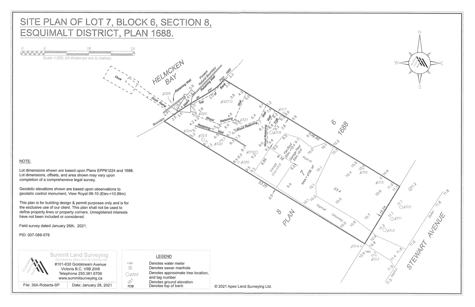
A legal survey site plan showing existing structures and topographical elevations for the development at 315 Stewart Ave.
Consultant: Summit Land SurveyingDate: January 28, 2021
SITE PLAN OF LOT 7, BLOCK 6, SECTION 8, ESQUIMALT DISTRICT, PLAN 1688.
Scale 1:250. All distances are in metres.
NOTE:
- Lot dimensions shown are based upon Plans EPP61224 and 1688. Lot dimensions, offsets, and area shown may vary upon completion of a comprehensive legal survey.
- Geodetic elevations shown are based upon observations to geodetic control monument, View Royal 06-10 (Elev.=10.99m)
- This plan is for building design & permit purposes only and is for the exclusive use of our client. This plan shall not be used to define property lines or property corners. Unregistered interests have not been included or considered.
- Field survey dated January 26th, 2021.
- PID: 007-088-078
LEGEND
- +WM: Denotes water meter
- (S): Denotes sewer manhole
- ○#322: Denotes approximate tree location, and tag number
- 10.1: Denotes ground elevation
- TOB: Denotes top of bank
Survey Information
- Surveyor: Summit Land Surveying (Operated by Apex Land Surveying Ltd.)
- Address: #101-630 Goldstream Avenue, Victoria B.C. V9B 2W8
- Telephone: 250.391.6708
- Website: www.summitsurveying.ca
- File: 36A-Roberts-SP
- Date: January 28, 2021
- Copyright: © 2021 Apex Land Surveying Ltd.
Site Details
- Lot Area: ±758 m²
- Civic Address: #315
- Structure Details:
- Garage
- Flat Roof Elev = 12.4
- Garage Floor Elev. = 9.8
- Site Features:
- Dock and Dock Ramp (Helmcken Bay)
- Retaining Walls (Wood and unspecified material)
- Stairs
- Driveway 5
- Stewart Avenue (Asphalt and Gutter)
- Adjoining Lots:
- Lot 6, Plan 1688
- Lot 8, Plan 1688
Page 236
Extracted from: 2021 06 08 Committee of the Whole Agenda - Agenda - Pdf