9 Erskine Lane Development Traffic Impact Assessment
A technical assessment of projected traffic volumes and intersection levels of service for the proposed residential development at 9 Erskine Lane.
4.4.1 HELMCKEN / WATKISS INTERSECTION
The following are the AM and PM peak hour post development traffic volumes at Helmcken Road / Watkiss Way.
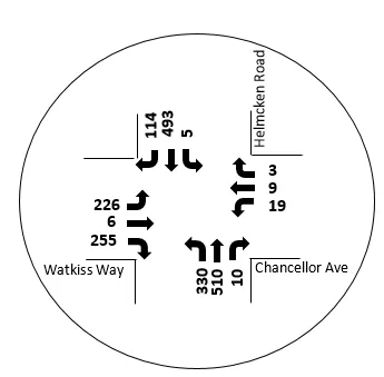
Figure 14: 2022 Post Development Helmcken Road/Watkiss Way Traffic
TABLE 10: 2022 POST DEVELOPMENT TRAFFIC CONDITIONS AT WATKISS/HELMCKEN
| Movement | 2022 AM Peak Hour | 2022 PM Peak Hour | ||||
|---|---|---|---|---|---|---|
| LOS | Delay (s) | 95th Queue (m) | LOS | Delay (s) | 95th Queue (m) | |
| EBL/T | D | 27.9 | 60 | E | 74.1 | 100 |
| EBR | A | 9.7 | 50 | C | 33.2 | 85 |
| WBL | C | 24.7 | 10 | D | 45.5 | 15 |
| WBT/R | B | 15.7 | 5 | C | 29.0 | 10 |
| NBL | E | 76.8 | 110 | F | 125.7 | 120 |
| NBT/R | B | 12.6 | 340 | B | 13.2 | 255 |
| SBL | D | 46.4 | 5 | E | 75.0 | 15 |
| SBT | C | 28.2 | 135 | C | 31.0 | 210 |
| SBR | A | 4.2 | 30 | A | 2.1 | 30 |
The addition of the 9 Erskine Lane development traffic does not change the LOS. The northbound left turn delays will increase due to the movement operating at a failing condition (under background and post development conditions). The northbound left queues, in the PM, will increase and extend beyond the available storage by several vehicles (similar to 2022 AM background conditions). The queue lengths could be mitigated by adjusting the signal timing; however, the change in signal timing would take green time from the heavily queued southbound movement. The northbound through queues are higher post development due to the minor spillback of the left turn lane. As volumes, overall, are expected to drop on the corridor with the completion of the McKenzie Interchange a change in signal timing due to the development is not recommended.
4.5 2032 POST DEVELOPMENT CONDITIONS
The 2032 AM and PM peak hour conditions are summarized in Table 11, and traffic volumes are shown in Figure 15. All intersections the Watkiss Way Corridor operate at LOS D or better in the AM and PM peak hours. The addition of site traffic adds on a few seconds of delay to some movements; however, the level of service for most movements are unchanged compared to background conditions. The northbound/southbound movements on Erskine Lane/Stoneridge Drive at Watkiss Way will drop to a LOS D in the long term (from LOS C). The eastbound queue at the roundabout will increase to 170m (from 110m); however, it will operate at a LOS C. Therefore this queue will be ‘rolling’.
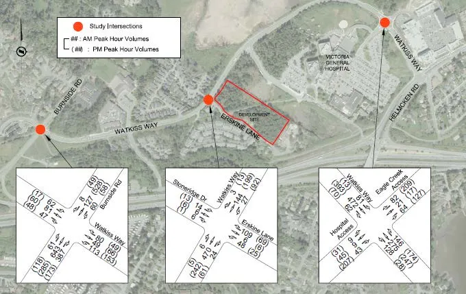
TABLE 11: 2032 POST DEVELOPMENT TRAFFIC CONDITIONS
| Intersection | Movement | 2032 AM Peak Hour | 2032 PM Peak Hour | ||||
|---|---|---|---|---|---|---|---|
| LOS | Delay (s) | 95th Queue (m) | LOS | Delay (s) | 95th Queue (m) | ||
| Burnside Rd W / Watkiss Way (Signalized) | EBLTR | C | 23 | 40 | B | 14 | 30 |
| WBLTR | D | 51 | 45 | D | 49 | 60 | |
| EB/WB=Watkiss Way | NBLT | C | 16 | 95 | B | 13 | 75 |
| NB/SB=Burnside Rd | NBR | A | 0 | 55 | A | 2 | 30 |
| SBLTR | B | 12 | 55 | B | 18 | 90 | |
| Watkiss Way / Erskine Ln | EBL | A | 8 | 10 | A | 8 | 5 |
| EBTR | A | 0 | 10 | A | 0 | 5 | |
| EB/WB=Watkiss Way | WBL | A | 9 | 15 | A | 9 | 20 |
| NB/SB=Stoneridge Dr-Erskine Ln | WBTR | A | 0 | 15 | A | 0 | 20 |
| NBLTR | D | 34 | 25 | C | 23 | 20 | |
| SBLTR | D | 29 | 15 | C | 24 | 10 | |
| Watkiss Way / Hospital - Mall Access | EBLTR | C | 30 | 170 | B | 15 | 55 |
| WBLT | B | 10 | 25 | A | 9 | 20 | |
| EB/WB=Watkiss Way | WBR | A | 0 | 0 | A | 1 | 20 |
| NB/SB=Hospital-Mall Access | NBLTR | A | 10 | 5 | C | 34 | 80 |
| SBLTR | B | 11 | 15 | B | 18 | 55 |
4.5.1 HELMCKEN / WATKISS INTERSECTION
Figure 15 [sic] is the 2032 post development traffic volumes.
Figure 16: 2032 Post Development Helmcken Road/Watkiss Way Traffic
TABLE 12: 2032 POST DEVELOPMENT TRAFFIC CONDITIONS AT WATKISS/HELMCKEN
| Movement | 2032 AM Peak Hour | 2032 PM Peak Hour | ||||
|---|---|---|---|---|---|---|
| LOS | Delay (s) | 95th Queue (m) | LOS | Delay (s) | 95th Queue (m) | |
| EBL/T | D | 39.3 | 70 | F | 96.0 | 100 |
| EBR | B | 16.3 | 65 | E | 66.9 | 80 |
| WBL | C | 24.6 | 10 | D | 49.4 | 20 |
| WBT/R | B | 14.3 | 5 | C | 27.4 | 15 |
| NBL | F | 149.4 | 115 | F | 188.4 | 110 |
| NBT/R | B | 14.9 | 295 | B | 14.3 | 345 |
| SBL | D | 48.3 | 10 | E | 76.5 | 15 |
| SBT | D | 42.8 | 415 | D | 43.2 | 305 |
| SBR | A | 6.2 | 30 | A | 3.3 | 30 |
In the long term, the addition of the development traffic does not change any of the LOS. However, if traffic volumes the worst case as projected the intersection should be reviewed to balance northbound left turn queues with southbound queues. Any adjustment in signal timing would require taking green time from one movement and moving it to another and any change in timing, even by 1 second may significantly impact the movement the time is taken from.
4.6 LEFT TURN LANE REVIEW
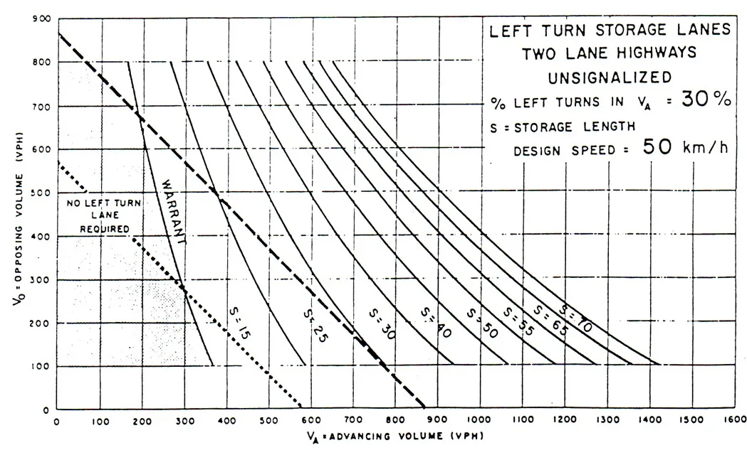
A left-turn lane warrant was conducted in the PM peak hour at Erskine Lane / Watkiss Way for the westbound-left turn movement at the intersection. Although there is no reported operational issue, the number of vehicles turning left is significant (92 vehicles) and is approximately 30% of westbound traffic on Watkiss Way in the PM peak hour. The left-turn warrant indicates that a 15m left turn lane is required, though the warrant is barely met as shown in Figure 17. It is recommended that a left turn lane be added on Watkiss Way with the development.
4.7 ERSKINE LANE / WATKISS ROAD
In 2032 during the AM peak hour the northbound (turning out of Erskine Lane) and southbound (turning out of Stoneridge Drive) will operate at a LOS D. This level of service will occur for one hour per day if traffic grows as projected. A review of three changes to traffic control were explored for this intersection to understand the potential impacts to changing the traffic control. Three options were reviewed: maintaining existing stop control on Erskine Lane/Stoneridge Drive, a roundabout, and a traffic signal. Tables 13 and 14 outline the LOS and queue lengths for each options.
TABLE 13: AM PEAK HOUR 2032 POST DEVELOPMENT OPTION COMPARISON
| Intersection | Movement | Existing Stop | Signal | Roundabout | |||
|---|---|---|---|---|---|---|---|
| LOS | Queue (m) | LOS | Queue (m) | LOS | Queue (m) | ||
| Watkiss Way / Erskine Ln / Stoneridge Dr | EBL | A | 0 | A | 5 | n/a | n/a |
| EBTR | A | 0 | B | 60 | A | 25 | |
| EB/WB=Watkiss Way | WBL | A | 5 | A | 5 | n/a | n/a |
| WBTR | A | 0 | A | 20 | A | 10 | |
| NB/SB=Erskine Ln / Stoneridge Dr | NB | D | 35 | B | 10 | A | 10 |
| SB | D | 10 | B | 10 | A | 5 |
TABLE 14: PM PEAK HOUR 2032 POST DEVELOPMENT OPTION COMPARISON
| Intersection | Movement | Existing Stop | Signal | Roundabout | |||
|---|---|---|---|---|---|---|---|
| LOS | Queue (m) | LOS | Queue (m) | LOS | Queue (m) | ||
| Watkiss Way / Erskine Ln / Stoneridge Dr | EBL | A | 10 | A | 5 | n/a | n/a |
| EBTR | A | 0 | A | 40 | A | 15 | |
| EB/WB=Watkiss Way | WBL | A | 10 | A | 15 | n/a | n/a |
| WBTR | A | 0 | A | 25 | A | 15 | |
| NB/SB=Erskine Ln / Stoneridge Dr | NB | C | 25 | A | 10 | A | 5 |
| SB | C | 25 | A | 5 | A | 5 |
The signal and roundabout option have similar traffic operations in terms of LOS/delay operating at a LOS A/B during the AM and PM peak hours in the long term with the development. The signal will operate with LOS B for the side street in the AM while the roundabout will operate at a LOS A. The introduction of a signal will increase the queues on Watkiss Road to up to 60m (approximately 8 vehicles stopped at the signal) while the roundabout queues will be up to 25m (3 vehicles). This is compared to no queues on Watkiss Road, as with the stop signs on the side streets, Watkiss Road traffic is not currently stopped. Both the signal and the roundabout improve the AM conditions on Erskine/Stoneridge from LOS D to LOS A/B and in the PM from LOS C to LOS A.
The roundabout has the least impact to traffic on Watkiss Road and provides the same or slightly better operations than a signal. Both the signal and the roundabout have the opportunity to provide crosswalks on all four legs. While a signal will provide for controlled crosswalks (with pedestrian signals), pedestrians at roundabout crosswalks only have to deal with one direction of traffic at a time and have a refuge area to wait in the middle of the roadway.
While there is available right-of-way for a roundabout it would require significant works to relocate sidewalks and utility poles as well as loss of mature vegetation that could expose residents’ backyards to Watkiss Way.
The adjacent development at 7 Erskine Lane was required to contribute to upgrading the intersection of Watkiss Way / Erskine Lane to a signal. Based on existing volume, the 7 Erskine volume, and the 9 Erskine volumes on the Erskine leg of the intersection each contributes the following percentage of traffic:
- Existing = 20%
- 7 Erskine = 15%
- 9 Erskine = 65%
4.8 REVISION TO SITE PLAN
In August 2020, a revision was made to the site plan which shows the reduced number of units for Lot B, effectively reducing two buildings by one floor (from six to five storeys). The development will now consist of 336 dwelling units in four mid-rise buildings (two of which remain six storeys and two of which are now reduced to five stories). Trip generation rates were re-estimated using the 10th Edition of the ITE Trip Generation Manual. Table 15 shows the updated estimated trips generated by the proposed development. They equate to 121 weekday AM peak hour trips and 148 weekday PM peak hour trips. Based on the revised site plan, the estimated site trips compared to Table 8 show 13 trips lower in the AM peak hour and 18 trips lower in the PM peak hour.
TABLE 15: PEAK HOUR DEVELOPMENT TRIPS
| Description | Units | Weekday AM | Weekday PM | ||||
|---|---|---|---|---|---|---|---|
| In | Out | Total | In | Out | Total | ||
| Multi-Family Housing (Mid-Rise) | 336 | 32 | 89 | 121 | 90 | 58 | 148 |
An analysis of the 2022 Post Development traffic was completed with the updated development trips and a comparison at the intersection of Watkiss/Helmcken was completed. The changes in LOS and Delay in the AM peak hour conditions are summarized in Table 16
TABLE 16: COMPARISON OF PEAK HOUR DEVELOPMENT TRIPS
| Movement | 2022 AM Peak Hour | 2022 AM Peak Hour (August 2020 Site Plan Update) | ||
|---|---|---|---|---|
| LOS | Delay (s) | LOS | Delay (s) | |
| EBL/T | D | 37.9 | D | 37.8 |
| EBR | A | 9.7 | A | 9.5 |
| WBL | C | 24.7 | C | 24.8 |
| WBT/R | B | 15.7 | B | 15.8 |
| NBL | E | 76.8 | E | 75.5 |
| NBT/R | B | 12.6 | B | 12.4 |
| SBL | D | 46.4 | D | 46.2 |
| SBT | C | 28.2 | C | 27.9 |
| SBR | A | 5.6 | A | 5.5 |
Upon review, the reduction in units (approximately 10%) will make a negligible difference as it pertains to traffic conditions previously analyzed.
5.0 TRAFFIC CALMING
Watkiss Way currently has approximately 5,000 vehicles per day on the corridor which by 2032 is projected to reach 8,000 vpd. At this level of volume the roadway is operating near an arterial road level (from a collector road) or as the Transportation Master Plan states a Major Roadway. The higher the road classification (arterial is the highest) the more the focus is on the mobility of traffic over access and calming traffic (by reducing volumes).
On an arterial roadway the main way to impact vehicle speeds and calm traffic is to change the road cross section to introduce more urban elements (such as sidewalks, medians, and landscaping) to visually narrow the roadway, along with physical narrowing of the lanes (to 3.3m) as well as added density (increased natural surveillance). The Town has DCC plans for this section of Watkiss Way that include narrowed lanes, medians with landscaping, and sidewalk. With the development adding a left turn lane for turning onto Erskine Lane there is an opportunity to narrow the lanes along the development frontage on Watkiss Way.
The short length of Erskine Road and the lack of connection to other roadways reduces the potential need for traffic calming since motorists on the street have limited distance speed. In addition any speeding issues that may occur would be due to residents of the street and would be better dealt with through education than traffic calming devices. The volume of traffic on the street would not be impacted by traffic calming devices and therefore should not be implemented.
6.0 ACCESS REVIEW
6.1 ACCESS SPACING
The proposed first site access is located on Erskine Lane 55m south of Watkiss Way. The provided 55m spacing exceeds the TAC’s minimum corner clearance of 15m for local roads from a stop-controlled major intersection. Therefore the location of the driveway access is appropriate. The spacing between the driveways exceeds 5m and therefore is also appropriate.
6.2 SIGHT DISTANCES
The sight distance at all the proposed accesses (on Erskine Lane) were reviewed to ensure sufficient sight distance is available for motorists turning into and out of the site. A 30 km/h speed limit sign is posted on Erskine Lane.
Sight distances are met for the access located south of the hospital trail. At the first access the measured sight distance to the right (north) is 50m which does not meet the required intersection sight distance (65m) for left turns from stop for 30 km/h. However, there is no reason for vehicles to turn left out of the site as a left turn would take drivers to a dead-end. If a rare vehicle turns left the approaching vehicle on Erskine Lane has sufficient sight distance to stop or slow for a turning vehicle. Table 17 provides a summary of sight distances at Access 1 for 30 km/h.
TABLE 17: SIGHT DISTANCES AT ACCESS 1 BASED ON 30KM/H
| Movement | Measured Sight Distance | Required Intersection Sight Distance | Sight Distance Met? |
|---|---|---|---|
| Left Turn from Stop | 100m (looking left) | 65m (looking left) | Yes |
| 50m (looking right) | 65m (looking right) | No | |
| Right Turn from Stop | 100m (looking left) | 55m (looking left) | Yes |
| Through Traffic (on Erskine Lane) | 50m+ (southbound) | 35m (SSD for 30 km/h) | Yes |
| 50m+ (northbound) | 50m (SSD for 40 km/h) | Yes |
7.0 ACTIVE TRANSPORTATION
7.1 PEDESTRIANS AND CYCLISTS
Currently, Erskine Lane does not have any pedestrian infrastructure, however the site benefits from proximity to two off-street multi-use pathways (i.e. Hospital trail & Galloping Goose Trail) that offer connections to all the key amenities in the neighbourhood, such as access to the Watkiss Way transit stops, the Victoria General Hospital and the Eagle Creek Village commercial area. The Hospital trail is a worn gravel pathway, over a CRD utility right-of-way that can be utilized by pedestrians, but is not fully accessible in its current condition. The developer should improve the trail to the Town’s trail standard. The Town will need to secure agreement from the CRD to allow for the improvement to the trail; however, having active surveillance along a utility right-of-way can benefit the CRD in the early detection of pipe breaks. The use of gravel allows for the CRD easily access and maintain their utilities with the right-of-way. The improvement should be along the right-of-way to the bus stop at Talcott.
There is a short section of sidewalk on the northwest side of Watkiss Way between the two sections of Stoneridge Drive and northeast to the bus stop. There is an additional shoulder (separate from the bicycle lanes) on the south side of Watkiss Way for pedestrians. A sidewalk is planned for the Watkiss Way frontage and together with the narrower lanes on Watkiss Way will support the traffic calming of this section of roadway. Pedestrians will be able to utilize this sidewalk to the existing bus stop along with the Hospital trail and Galloping Goose as safe, separated alternatives to walking along Watkiss Way. No cycling infrastructure is existing along Erskine Lane, but there are bicycle (painted) lanes on Watkiss Way in the Saanich and View Royal sections. There is a connection to the Galloping Goose Trail at the end of Erskine Lane.
The proposed development is expected to add pedestrians around the area due to the addition of the multi-family residential units. A sidewalk along the development’s Erskine Lane frontage would aid in linking the site to Watkiss Way, the Hospital trail, and the Galloping Goose Trail. The Hospital trail provides a parallel pedestrian pathway to using Watkiss Way, connecting Hospital Way, Game Road, and the intersection of Watkiss Way and Talcott Road. The Galloping Goose crosses Talcott Road, south of the Hospital trail, which allows pedestrians and cyclists to connect to the Galloping Goose as well as at the end of Erskine Lane.
Since Erskine Lane is a dead-end roadway less than 300m in length vehicle speeds and volumes are not expected to be significant enough to require separation between bicycles and vehicles. Bicycles will continue to share the roadway on Erskine Lane.
7.2 TRANSIT
There are three routes (# 14, 22 and 39) within walking distance (within 300m) from the subject site. For the transit route #14 and #22, the closest bus stop is on Hospital Way (Victoria General Hospital) north of the development site (via pedestrian trail) and provides service to Downtown Victoria several times per hour on weekdays. Transit users from the site can utilize the hospital trail (Game Road) between Erskine Lane and Victoria General Hospital to access the bus stops. For the transit route #39, the closest bus stop is on Watkiss Way east of Erskine Lane and provides service to the University of Victoria via Camosun College (Interurban Campus) one or two times per hour. The Galloping Goose connection at the end of Erskine Lane puts the transit stops at the Helmcken Road Interchange within 800m of the site. The stops at the Interchange include the #47, 48, 50, 51, 61, and 65 buses. The proximity to these transit routes will draw residents who want to utilize alternative modes of transportation.
8.0 TRANSPORTATION DEMAND MANAGEMENT
Transportation Demand Management (TDM) refers to policies, programs and services that influence whether, why, when, where and how people travel. TDM initiatives typically aim to reduce vehicle trips and parking demand while encouraging alternative travel options such as walking, cycling, public transit, and shared rides. This site is in an ideal location to implement TDM to support a reduction of single-occupant vehicle trips to and from the site and encourage use of alternative modes. The following outlines the TDM planned by the developer.
8.1 ELECTRIC BICYCLES
Electric Bikes (E-bikes) are an emerging transportation phenomenon that are gaining popularity worldwide. With supportive cycling infrastructure in place, E-bikes have the potential to substitute or completely replace almost all trips taken by combustion engine vehicles which can help to address congestion issues and mitigate parking challenges in urban areas. Two barriers facing prospective E-bike users is the lack of secure parking which is critical for minimizing E-bike theft and cost.
The Developer is providing two electrical bicycles to be shared by the complex. Access to electrical bicycles allows residents to experience an e-bicycle without having to outlay the costs which can be high. E-bicycles also support longer commuter trips as well as increase the ability to carry heavier grocery items or other goods. As part of a larger strategy to discourage vehicle ownership for future residents, the applicant should consider designing up to 10% of the long-term bicycle parking spaces to accommodate electric bikes.
8.2 SECURE BICYCLE PARKING
Research has reported that bicycle parking supply is a determinant of cycling for current and potential cyclists. A lack of bicycle parking and/or inadequate bicycle parking discourages cycling. Higher quality bicycle parking facilities are associated with more bicycle use. Further, more convenient bicycle parking is also associated with more cycling. Convenience includes easy access to bicycles, e.g. short distances between bicycle parking and actual trip origins or destinations. Secure bicycle parking could especially benefit the residents of this development, with direct access to the Galloping Goose trail.
8.3 CARPOOLING
An informal rideshare program could be implemented on site that will allow residents to identify if they require a ride or if they can provide a ride. This will be particularly useful for those residents who work in proximity to each other and have similar shifts. An informal program could be implemented internally, with a sign-up sheet in the lobby, or residents can be encouraged to sign up for carpool.ca.
8.4 CARSHARE
Carsharing is a form of car rental service for the sharing of vehicles for varying lengths of time. Carshares are usually co-operative and require users to register as a member to use vehicles and pay associated fees. An external carshare program could be considered for the site for those residents who may occasionally need access to a vehicle, but may not be able to pay the costs associated with vehicle ownership. External carshare programs such as Modo, would not be reserved exclusively for residents at the site, but shared with other Modo members in the area. Although, Modo is not currently operating in View Royal, the developer could facilitate a conversation with Modo Carshare Corporation (the current managing corporation of the carshare program in Victoria) and the Town of View Royal to encourage the program to be expanded to the area. Given the significant population growth in the area (e.g., 7 Erskine Lane, Eagle Creek Village, Eagle Creek Nest), there may be a growing user base that would benefit from carsharing.
Research has shown that carsharing programs have a significant impact on reducing vehicle ownership, thereby reducing site trips and lowering parking demand. Currently, there are no Modo vehicles near the site, but the developer is planning to provide two carshare vehicles. At this time it has not been confirmed if these are going to be shared vehicles for the development or part of Modo.
8.5 TDM IMPACT ON TRAFFIC
This study is based on standard ITE Trip Generation rates and does not account for the potential reduction in vehicle trips due to the planned TDM. The planned TDM along with the close proximity / easy access to the Galloping Goose, multiple transit routes heading in all directions, and the Eagle Creek commercial amenities is expected to reduce vehicle trips by at least 10% reduction in the trips generated by this development. This equates to a reduction of 16 vehicles during the peak hours and 55 vehicles per day.
At this time it is unknown if the demographics of this site will draw hospital workers; however, due to its close proximity to the hospital it is expected a portion of the residents will be employed at Victoria General. The close proximity of the site, along with the Hospital trail will allow hospital workers to walk to cycle to/from work which would further reduce the vehicle traffic generated by the site.
9.0 CONCLUSIONS
The development will not significantly impact the traffic operations at the three Town intersections. All movements will operate at LOS D or better in the long-term in both the background and post development conditions. A 15m left turn lane on Watkiss Way at Erskine Lane should be implemented with the development. A change in traffic control is not required in the short term; however, in the long term the side streets drop to a LOS D at Watkiss Way/Erskine Lane. Therefore this development should contribute funding for their portion of the traffic signal (65% of the Erskine Lane leg cost).
At the Watkiss Way / Helmcken Road intersection the addition of the development does not impact the levels of service. However, queues are an existing challenge on Helmcken Road and are expected to grow based on the existing traffic growing at 2% per year and this development. The opening of the McKenzie Interchange is expected to mitigate the existing volumes, and therefore reduce the projected background traffic, as traffic will shift to the free-flow conditions at the interchange over the stop and go traffic on Burnside Road, Helmcken Road, and Watkiss Way (due to the signals). Reduction in the background volumes will improve existing queues and mitigate queuing impacts due to development in the Watkiss-Helmcken-Burnside area. In addition, the proposed TDM program (two car share vehicles, two shared e-bikes, and secure bicycle parking) along with the proximity to the Galloping Goose, transit and amenities at Eagle Creek the projected traffic volumes for this site are conservative and are expected to be at least 10% less than utilized for this worst case analysis.
The proposed first site access location does not meet the TAC’s intersection sight distance for left turns from stop for a design speed of 30 km/h; however, since the road to the left does not connect to another road it is unlikely that any vehicles will turn left. If a vehicle is approaching from the south and a vehicle does turn left the approaching vehicle has sufficient sight distance to stop for a turning vehicle. The sight lines for a right turning vehicle are met. Therefore, the proposed access location is acceptable from a sight distance safety perspective.
A sidewalk should be provided along the Erskine Lane development frontage to provide a better connect to the Hospital trail, and Galloping Goose Trail. A sidewalk along the Watkiss Way frontage would upgrade this section of Watkiss to an urban (sidewalk) standard. Along with narrowing the lanes on Watkiss Way (due to the proposed left turn lane) the change in cross section will support traffic calming of this section of Watkiss Way. The developer should contribute to upgrading the Hospital trail to a gravel pathway, subject to the CRD’s agreement. No new bicycle facilities are required since there are bicycle lanes on Watkiss Way and the volume of traffic on Erskine Way does not necessitate the need for separate facilities on Erskine Way.
Traffic calming is not required on Erskine Lane due to the short length of the street and the lack of connectivity to other streets. Traffic calming on Erskine Lane would not reduce traffic (as all traffic would be due to land uses on the street) and there is limited ability to speed due to the length.
A review was completed with the reduction in proposed units (approximately ~10%) from 372 units to 336 units. Upon analysis review it has been determined that this reduction will make a negligible difference as it pertains to overall traffic impact and the recommendations made below are still valid.
10.0 RECOMMENDATIONS
- The developer will provide a sidewalk along the Erskine Lane and Watkiss Way development frontages.
- The developer to implement TDM strategies (car share vehicles (2) and electric bicycle share (2)) to reduce vehicle traffic and encourage active modes.
- The developer to provide a left turn lane on Watkiss Way at Erskine Lane.
- The developer to contribute towards the signalization of Erskine Lane / Watkiss Way.
- The developer to provide funds for upgrading the Hospital trail to at least a 3m gravel pathway.
The Town should work with the CRD to determine and acceptable arrangement for the implementation of the formal gravel trail on the CRD’s right-of-way (known as Hospital trail).
Document Images
(1)