REZONING 2020/05 9 Erskine Lane - Staff Presentation
A municipal staff presentation detailing a rezoning application for 9 Erskine Lane, comparing it to previous proposals and addressing transportation, environmental impact, and community amenity contributions.
REZONING 2020/05
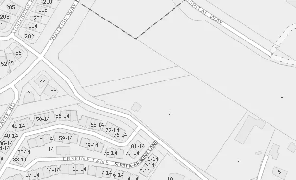
9 Erskine Lane
- The proposal is now for sidewalks on Erskine Lane and Watkiss Way, bus/pad stop, roundabout at Watkiss Way and Erskine Lane, widening Erskine Lane.
- Two storey underground parking (last application single storey).
- 20-year rental housing covenant instead of the previous 10 year.
- Pre-wiring for electric vehicle charging for all parking spaces and provision of four carshare cars (one per building).
- Provision of a play structure either on-site or at nearby Game Nature Park. Game Nature Park is primarily a natural park, and staff would prefer that the play structure be located on the subject property. This does mean that it would not be accessible to the public; only residents and guests.
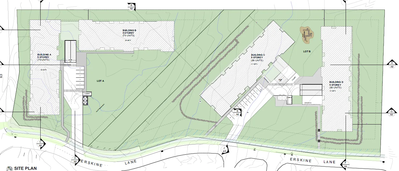
| PROPOSED LOT A | PROPOSED LOT B | PROPOSED COMBINED | PREVIOUSLY PROPOSED (COMBINED) | |
|---|---|---|---|---|
| Lot Size | 8,575m2 | 12,856m2 | 21,413m2 | 21,413m2 |
| Floor Area | 12,360m2 | 13,650m2 | 26,010m2 | 28,740m2 |
| Density | 1.45 FSR | 1.07 FSR | 1.22 FSR | 1.35 FSR |
| Units/Hectare | 184 | 138 | 157 | 174 |
| Units/Acre | 75 | 56 | 64 | 71 |
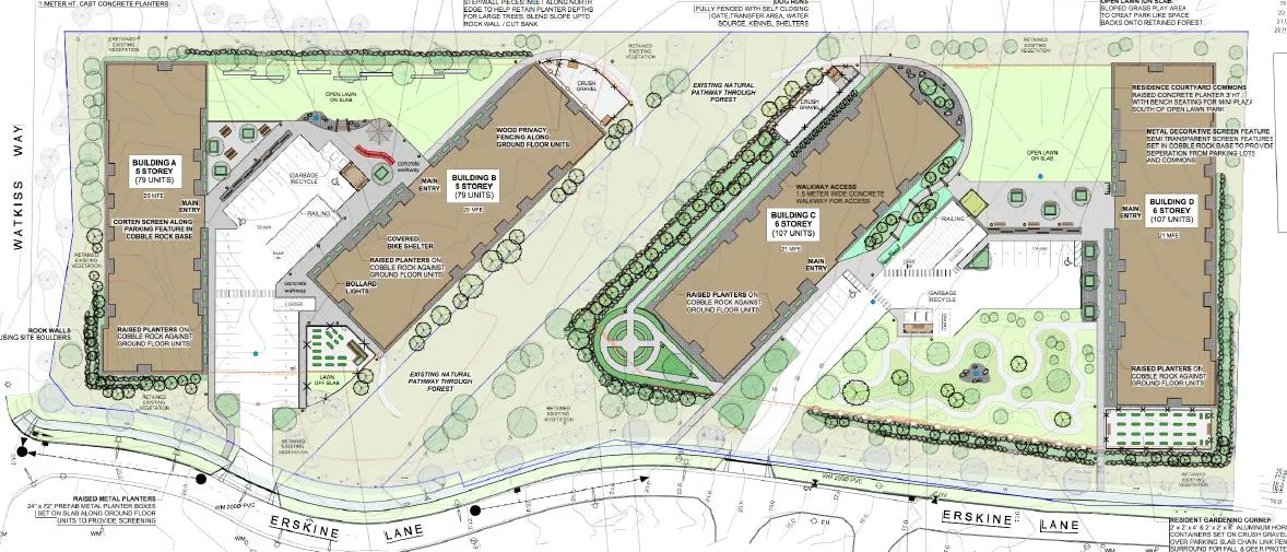
| Building Heights | 5 storeys | 5 storeys | 5 storeys | 5-6 storeys |
| Site Coverage | 30% | 22% | 25% | 25% |
| Units Proposed | 158 | 178 | 336 | 372 |
| Vehicle Parking | 164 | 178 | 342 | 485 |
Unit Mix
- 16 studio units
- 160 one-bedroom units
- 120 two-bedroom units
- 40 three-bedroom units
Building Height
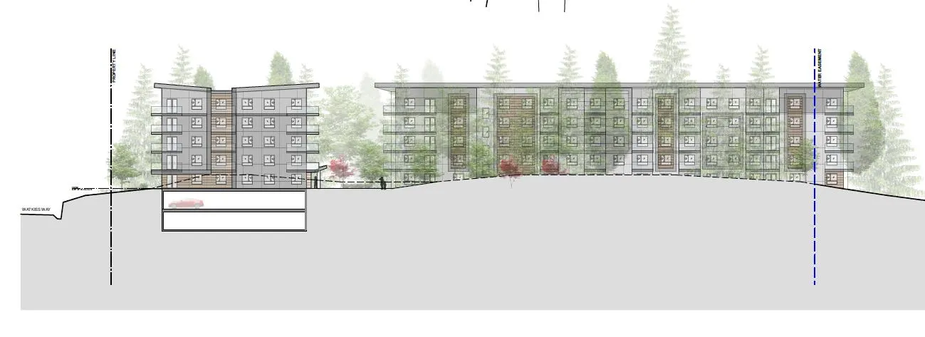
15.5m and 5 storeys tall, as measured from the base of the building. Final heights from (calculated) average grade would be finalized at time of Development Permit.
More refinement and detail could be done prior to readings to ensure certainty of the building heights during readings of the bylaw.
Two levels of underground parking proposed.
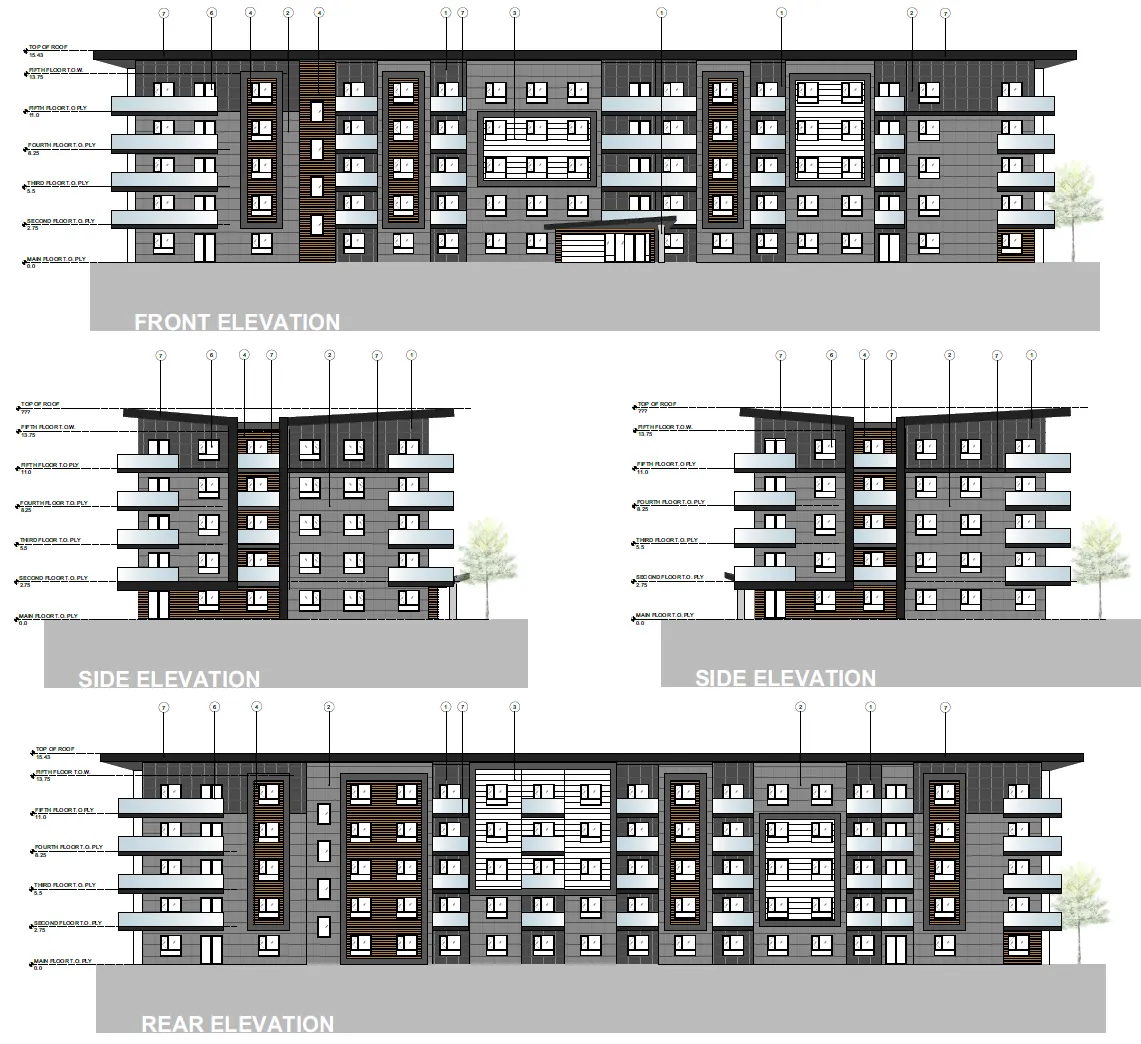
The proposed zoning can be supported because it would comply with the policies encouraging the growth of the Hospital Neighbourhood Centre as a complete community as follows:
- Higher density at a neighbourhood center would be provided in a location that will promote walkability, cycling and transit use by locating more residences closer to services and employment.
- Higher density rental residential uses can increase workforce housing to support the Hospital and local businesses in the neighbourhood center.
- Increasing the supply of rental housing can assist with housing affordability in the region.
- Community amenity contributions are proposed that can be used to fund local improvements to enhance pedestrian safety and neighbourhood quality of life.
Building Height
Transportation Impact
The updated transportation impact assessment concludes that the development would not significantly impact the Watkiss Way/Erskine Lane intersection’s current Level of Service (A/B) and recommends that:
- The developer will provide a sidewalk along the Erskine Lane and Watkiss Way development frontages.
- The developer to implement TDM (Traffic Demand Management) strategies (car share vehicles (2) and electric bicycle share (2)) to reduce vehicle traffic and encourage active modes.
- The developer to provide a roundabout at intersection of Watkiss Way and Erskine Lane.
- The developer to provide funds for upgrading the Hospital trail to at least a 3m gravel pathway.
Site Servicing
With the reduced density, Islander Engineering offers the following:
Because our captioned design brief was crafted for a higher density of the same usage, there are no concerns from an engineering site servicing or traffic perspective over and above what was identified in our Technical Design Brief dated October 9, 2019.
In our professional opinion, there is no need to update our technical report during this land usage stage. Once the land is rezoned for the proposed use and a DP/BP is being considered, we would recommend that you revisit the densities so that Islander can revise conceptual designs.
Tree Protection
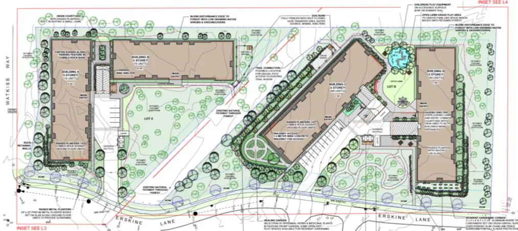
Due to the reconfiguration of the parking, the applicant is proposing that 40% of the current tree coverage will be retained and is proposing to replant ‘over 250’ trees. Additional consideration of tree protection and retention can be made by Council at time of Form and Character Development Permit.
Bird Habitat
Active bird nests are protected between March and August under the Wildlife Act. Only significant nest was potentially a Cooper’s Hawk or Common Raven nest. The Province’s 2005 Best Management Practices for Raptor Conservation during Urban and Rural Land Development in British Columbia report notes the following about the Cooper’s Hawk:
- Among the species that are relatively compatible with human activity and are most likely to benefit from BMPs [best management practices] in urban and rural environments.
- Can nest near human developments.
- Prefers an area of interlocking tree canopy for rearing young.
- Greater Victoria contains one of the highest nesting densities of this species in North America.
Riparian Areas
A report from a registered professional biologist confirms that the ditch along the Watkiss Way frontage is not a watercourse and therefore not subject to the Riparian Areas Regulation.
Geotechnical
A geotechnical overview concludes there are no preliminary indications of geotechnical issues, although it notes that “careful consideration will be required if it is desired to build in vicinity of the 8 to 10m rock cut along the north east property line.”
Electric Vehicle Charging Stations
For this development concept, the Zoning Bylaw requires one electric vehicle charging station on the lot in a location which is accessible to visitors or residents. The development concept would provide pre-wiring for every vehicle spot.
Public Engagement
In the previous application the applicant indicated that their public engagement initiatives included the following:
- January 2020 - door to door campaign in the Erskine Lane, Stoneridge and Eagle Creek Village areas
- January 27, 2020 - open house
- March 4, 2020 - open house
- July 2020 – Flyer distribution with link to the WestUrban website for information and opportunities for comment.
With COVID opportunities for further public input in-person would likely have been limited. The current application here is a result of the engagement with the Town and the public, and the associated changes to the plan.
Community Amenity Contribution
In accordance with the Community Amenity Contributions Policy, the policy rate is $3,500 per attached residential unit. For this proposal, the amount would be 336 x $3,500 = $1,176,000.
The OCP recommends that a contribution to the Regional Housing Trust Fund be made.
Other viable solutions discussed include Game Nature park improvements, pedestrian and cycling improvements to the Erskine/Watkiss intersection around the proposed roundabout.
ANALYSIS AND DISCUSSION
The applicant has responded to Council input from the last application by providing a proposal with less units, lower density, lower height, more underground parking, a revised site layout, and other small refinements.
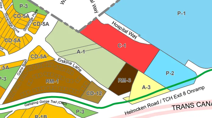
In comparison to the other recent rezoning immediately adjacent, 7 Erskine Lane is zoned RM-3 and proposed a higher maximum density (1.6 FSR) and similar building height (13.5m) than the proposed for 9 Erskine Lane.
Conclusion
The application is consistent with the OCP, offers a robust Community Amenity Contribution, meets the Hospital Neighbourhood Centre goals, and offers a sustainable approach to development.
Staff is supportive of this application.
RECOMMENDATION:
THAT Council receive the report from the Community Planner entitled “REZONING – 9 Erskine Lane 2020/05” and dated September 9, 2020 for information.
Document Images
(1)