Committee of the Whole/Documents/B.C. LAND SURVEYOR'S SITE PLAN OF: LOT 1-A, BLOCK 12, SECTION 27, ESQUIMALT DISTRICT, PLAN 1688
Appendix
B.C. LAND SURVEYOR'S SITE PLAN OF: LOT 1-A, BLOCK 12, SECTION 27, ESQUIMALT DISTRICT, PLAN 1688
September 15, 2020Page 5481 section
Detailed surveyor's site plan for 275 Kerwood Street showing property boundaries, elevations, and the natural boundary.
May 14, 2019275 Kerwood Street866+ square meters site area
B.C. LAND SURVEYOR'S SITE PLAN OF:
LOT 1-A, BLOCK 12, SECTION 27, ESQUIMALT DISTRICT, PLAN 1688
Property Identification
- Parcel Identification Number (PID): 001-622-161
- Site Area: 866± m²
- Municipality: TOWN OF VIEW ROYAL
- Civic Address: 275 KERWOOD STREET, VIEW ROYAL, BC
- Zoning: R-1
Legend
- Elevations are geodetic based on GPS measurements.
- Note: Only trees with Trunk greater than 0.20m are identified. Consult Arborist to verify tree species.
- Grade shots are taken at the point marked X.
- Contours are descriptive, and only accurate to +/- 0.5m interval.
- ● - denotes Iron Pin Found
- TRD - denotes Deciduous Tree Type
- TRC - denotes Coniferous Tree Type
- -O- - denotes Power pole
- Ⓤ - denotes unmarked manhole
- T:X.XX - Top of Wall
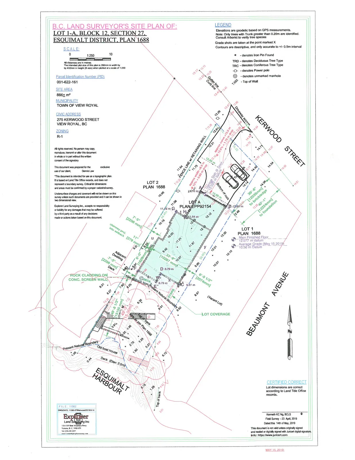
Survey Map Details
- Scale: 1:250
- Main Finished Floor: 12.077 m datum
- Average Grade (May 15, 2019): 10.56 m Datum
- Property Boundaries and Adjacent Lots:
- LOT 2 PLAN 1688
- LOT A PLAN EPP92154
- LOT 1 PLAN 1688
- Key Measurements and Setbacks:
- 15m setback from Present Natural Boundary
- 39'-6" [12035mm] to brickledge
- 40'-1" [12224mm] to foundation
- 6'-9 1/2" [2074mm]
- 7'-5" [2256mm]
- Chimney proj. into setback [279 mm] 11"
- Existing Features:
- Old boat house
- Deck (Elev: 2.5m)
- Rock cladding on conc. screen wall
- Lot coverage area
General Notes
- All rights reserved. No person may copy, reproduce, transmit or after this document in whole or in part without the written consent of the signatory.
- This document was prepared for the exclusive use of our client, Dennis Law.
- This document is intended for use as a topographic plan. It is based on Land Title Office records, and does not represent a boundary survey. Critical lot dimensions and areas must be confirmed by a proper cadastral survey.
- Undersurface charges and covenant will not be shown on this survey unless such documents are provided and it can be shown in two dimensional view.
- Explorer Land Surveying Inc., accepts no responsibility or liability for any damages that may be suffered by a third party as a result of any decisions made or actions taken based on this document.
- Lot dimensions are correct according to Land Title Office records.
Document Administration
- File: 11562
- DWG/DATE: 11562-275Kerwood2019-5-14
- Field Survey: 23 April, 2019
- Dated: 14th of May, 2019
- Surveyor: Kenneth KC Ng, BCLS
MAY 15, 2019.
Page 548
Extracted from: 2020 09 15 Committee of the Whole Agenda - Agenda - Pdf