PLANNING & DEVELOPMENT REPORT: OCP AMENDMENT 2020/01 and REZONING 2020/04 – 298 Island Highway
A staff report proposing the redevelopment of 298 Island Highway into a six-storey building with commercial use and 54 apartment units.
TOWN OF VIEW ROYAL PLANNING & DEVELOPMENT REPORT
TO: Committee of the Whole DATE: September 9, 2020 FROM: J. Chow, MCIP RPP, Senior Planner MEETING DATE: September 15, 2020 FILE NO.: 3440-20-2020/01, 3360-20-2020/04
OFFICIAL COMMUNITY PLAN AMENDMENT APPLICATION 2020/01 and REZONING APPLICATION 2020/04 – 298 Island Highway
RECOMMENDATION
THAT the September 9, 2020 report from the Senior Planner titled “Official Community Plan Amendment Application 2020/01 and Rezoning Application 2020/04 – 298 Island Highway” be received for information;
AND THAT Council requires early and ongoing consultation of the Official Community Plan amendment;
AND FURTHER THAT notification to BC Hydro, BC Ministry of Transportation and Infrastructure, BC Transit, Canada Post, Capital Regional District, Esquimalt First Nation, FortisBC, School District No.61, Shaw Cable, Songhees First Nation, and Telus be made of the public hearing for the proposed Official Community Plan amendment bylaw.
CHIEF ADMINISTRATIVE OFFICER’S COMMENTS
I concur with the recommendation.
DIRECTOR OF DEVELOPMENT SERVICES’ COMMENTS
I concur with the recommendation.
DIRECTOR OF ENGINEERING’S COMMENTS
I concur with the recommendation.
DIRECTOR OF PROTECTIVE SERVICE’S COMMENTS
I concur with the recommendation.
PURPOSE OF REPORT
- To introduce Official Community Plan Amendment Application 2020/01 and Rezoning Application 2020/04 to redevelop the property at 298 Island Highway for commercial and residential use.
BACKGROUND
The 1853 m² subject property is zoned C-1: Community Commercial and is located at the east corner of the Island Highway / Helmcken Road intersection. A single storey restaurant building with surface parking has occupied the lot since the early 1980s. Surrounding land uses include:
- To the north across Helmcken Road: George’s Corner Park and a detached residential neighbourhood.
- To the east, detached residential properties on Eltham Road (zoned C-1 Community Commercial) and the Lions Cove apartment building.
- To the south across the street: View Royal Square, a two and a half storey office/retail commercial building.
- To the west, across the intersection: Commercial uses including a former motel and the Salvation Army retail store.
A site profile has been submitted to the Province Contaminated Sites Branch noting the presence of an underground tank. The applicant’s environmental consultant is conducting a site investigation to support a release that would allow the development proposal to proceed through bylaw consideration.
PROJECT INFORMATION
The applications for this property are as follows:
- Official Community Plan amendment to change the land use designation from Neighbourhood Mixed Use (1.5:1 Floor Space Ratio) to a new Comprehensive Development Area that would permit commercial and residential use at 3.0:1 FSR.
- Rezoning from C-1: Community Commercial to a new zone permitting commercial and residential use. The rezoning application addresses zoning issues of land use, density, and standards for lot coverage, percentage of impervious surface, the height and siting of buildings in general.
The following attachments to this report provide more information on the proposal:
- Subject Property Map
- Subject Property Orthophoto
- Letter from Applicant
- Open House letters
- Design Rationale
- Architectural Drawings
- Landscape Plan
- Traffic Impact Assessment
- Water, Storm and Sanitary Review
Development Concept
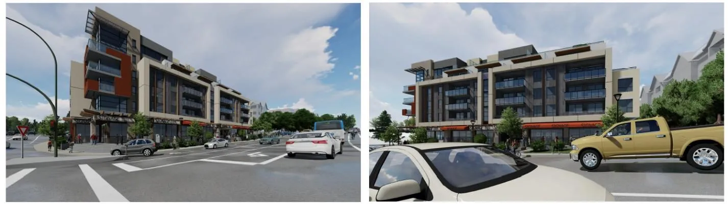
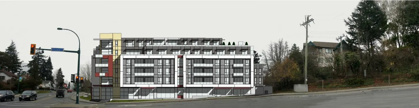
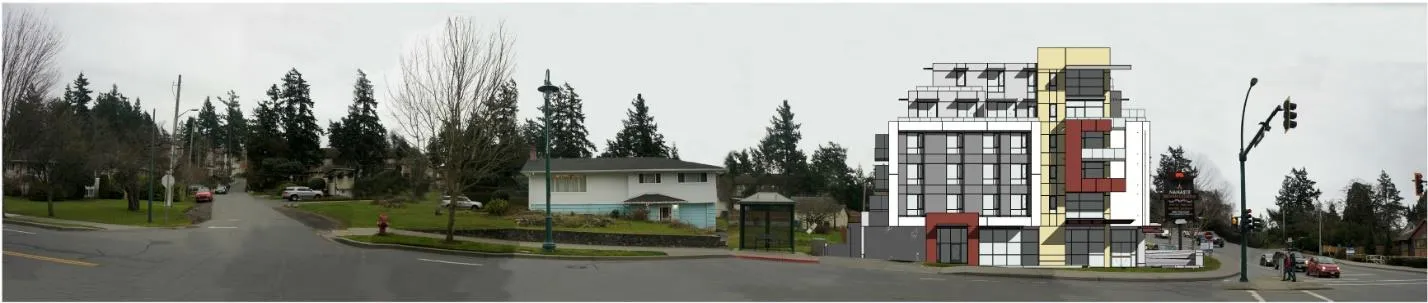
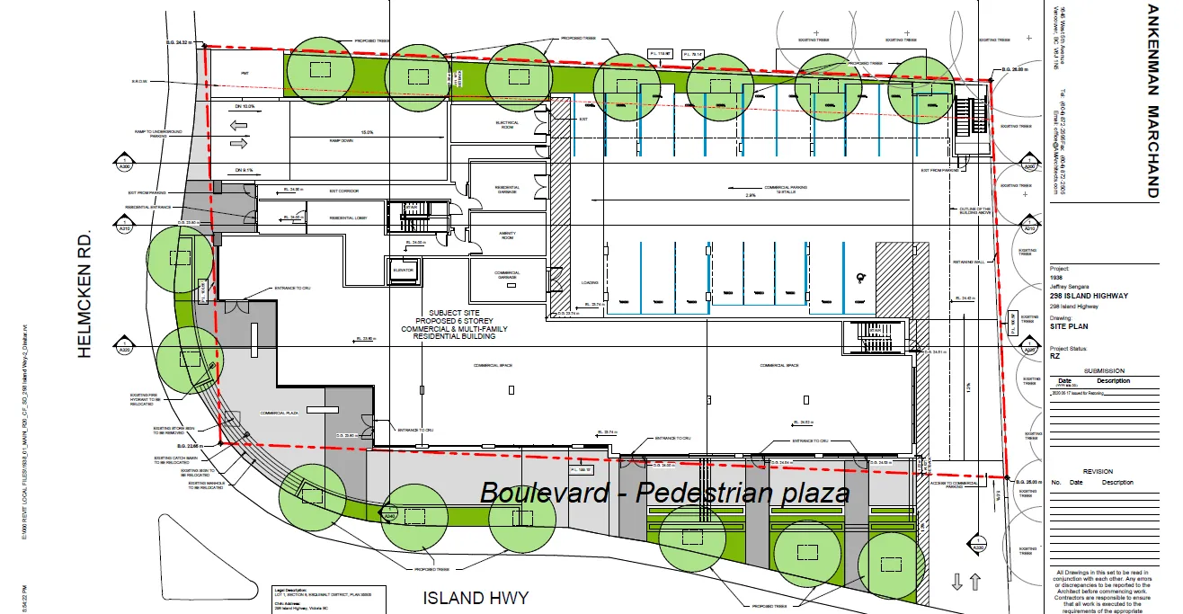
The development concept (Attachments 5-7) is for a six-storey building with the upper two storeys set back as shown in Figures 1-3. The ground floor would be 560m² commercial use with 54 apartment units on the five upper floors. Two levels of underground parking are proposed.
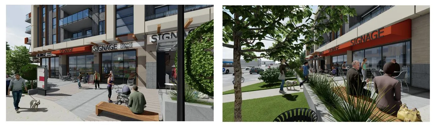
The average depth of the boulevard along Island Highway is over 6m, which would allow the creation of a pedestrian plaza as shown in Figures 4 and 5.
There are two small trees on the property and bushes along shared property lines. The landscape plan (Attachment 7) proposes more trees to screen adjacent Eltham Road properties.
Site Data Summary
| Lot Size | 1853m² |
|---|---|
| Floor Area | 5559 m² |
| Floor Space Ratio | 3.0:1 |
| Units/Hectare | 292 |
| Building Height | 20.3m |
| Storeys | 6 |
| Site Coverage | 75% |
| Units Proposed | 54 |
| Vehicle Parking | 104 (102 required) |
| Secure Bicycle Parking | 62 (56 required) |
Document Images
(2)