Planning & Development Report - Development Permit Application 2019/02 - 1938 West Park Lane
Report on a proposal to clear/grade land and facilitate a two-lot subdivision on a 5.18 ha parcel.
TOWN OF VIEW ROYAL
Planning & Development Report
| TO: | Committee of the Whole | DATE: | April 2, 2019 |
| FROM: | J. Chow, Senior Planner | MEETING: | April 9, 2019 |
| FILE NO.: | 3060-20-2019/02 |
DEVELOPMENT PERMIT APPLICATION 2019/02 - ENVIRONMENTAL - 1938 WEST PARK LANE
RECOMMENDATION:
That the April 2, 2019 report from the Senior Planner titled “Development Permit Application 2019/02 – Environmental - 1938 West Park Lane” be received for information.
CHIEF ADMINISTRATIVE OFFICER’S COMMENTS: I concur with the recommendation.
DIRECTOR OF DEVELOPMENT SERVICES’ COMMENTS: I concur with the recommendation.
DIRECTOR OF ENGINEERING’S COMMENTS: I concur with the recommendation.
A/DIRECTOR OF PROTECTIVE SERVICE’S COMMENTS: I concur with the recommendation.
PURPOSE:
- To introduce an environmental development permit application to clear/grade land and to facilitate a subdivision to create one additional lot.
- To seek comments and determine what additional information is needed for consideration of the application.
BACKGROUND:
The triangular 5.18 ha parcel is north of Trans Canada Highway and backs on to Thetis Lake Regional Park as shown in Attachment 1. Access is from West Park Lane at the southeast east corner. The west half of the site is primarily hilly, forested terrain with a rocky hilltop to the north. Thetis Lake Campground operated for decades on the east half of the property as shown in Attachment 2. The campground is closed and several buildings remain, including a house, office, washrooms, and sheds.
The following land use approvals were granted in 2017:
- Amendment of the Official Community Plan designation from “Parks Recreation and Open Space” to “Residential”.
- Inclusion in the Mixed Residential Development Permit Area to enable regulation of the form and character of multiple family residential development.
- Inclusion in the Sensitive Terrestrial Ecosystems Development Permit Area to address the natural environment, wildland/urban interface and steep slopes.
- Rezoning from C-6: Tourist Commercial (Campground) to CD-23 Comprehensive Development (Thetis Lake).
Community amenities secured in association with the rezoning included transfer to the Town of 5.12 ha adjacent to Mill Hill Regional Park (completed) and sidewalk improvements on Six Mile Road and West Park Lane (secured in a covenant).
PROPOSAL:
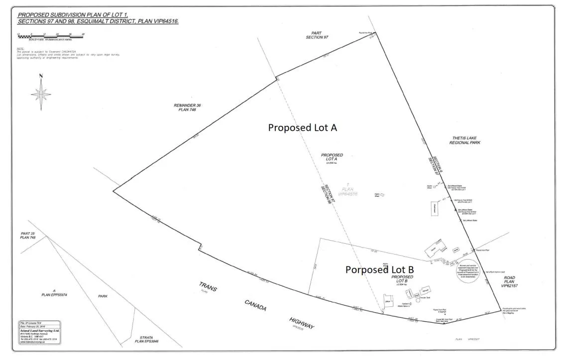
The applicant requests a development permit to clear/grade land and to facilitate subdivision of the 5.181ha parcel into two lots as shown in Figure 1. Lot A would be approximately 42,580m² and Lot B would be 9347m². Site access and offsite servicing will be addressed in the subdivision process by the Approving Officer.
The applicant’s development concept when rezoning in 2017 was for 306 multifamily units comprised of four apartment buildings and 46 townhouse/duplex units as shown in Attachment 5. The revised concept (Attachment 6) is for two apartment buildings plus attached/townhouse/duplex units on Lot A and 152 multifamily residential units in two apartment buildings on Lot B. Additional development permits for form & character of the development will be required.
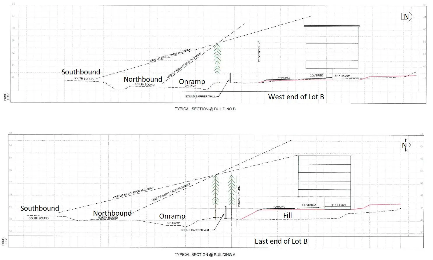
To prepare for construction on proposed Lot B, the applicant proposes to clear the land and grade it to create a level site. This would be achieved by cutting up to 9.2m into the slope on the west end of the proposed lot and filling in the low areas at the east end by up to 6.7m as shown in Attachment 7. A concurrent development permit application (DP2019/03) has been submitted for the form and character of development on proposed Lot B, which provides assurance that the project is moving forward. The grades relative to the Trans Canada Highway is illustrated in Figure 3. A retaining wall will be needed along the Trans Canada highway frontage and will be addressed in Development Permit 2019/03. Additional information should be provided on blasting protocols and controls (including notification for park users) and on site security and parking management (workers and park users).
The applicant has also indicated that they would like to alter land on proposed Lot A prior to submitting a form and character development permit for that lot. Proposed work includes depositing soil and rock on Lot B as fill. This is a highly visible and sensitive site, so disturbance should be minimized as there is no form and character development permit committing to a site layout. Further information should be provided on the extent of the proposed works on proposed on Lot A, including:
- Grading plan showing extent of clearing, blasting, grading, excavating or filling
- Tree protection measures
- Fencing of buffer areas abutting Thetis Lake Regional Park
- Blasting protocols and controls (including notification for park users)
- Extent of on-site servicing and road construction
- Site security and parking management (workers and park users)
DISCUSSION:
Key issues include the following:
- How does the proposal address the relevant development permit guidelines?
- How does the proposal comply with zoning requirements?
- What are the next steps toward Council consideration of the proposal?
1. Development Permit Area Guidelines
A biophysical assessment has been provided in Attachment 8 to address the guidelines of the Sensitive Terrestrial Ecosystems Development Permit Area. Additional information to be provided is listed in Section 3 (Next Steps). Key points are as follows:
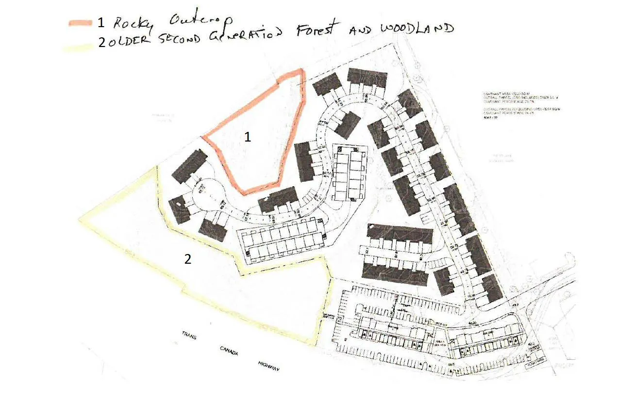
General i. Two sensitive ecosystem areas (“Rocky Outcrop” and “Older Second-Generation Forest and Woodland”) have been identified as shown in Figure 2 and in Appendix 2 of Attachment 8. viii. The two areas are contiguous to natural areas in Thetis Lake Regional Park to provide a contiguous green space. It should be noted that CRD Parks will not permit direct access from the site into the park.
Wildland/Urban Interface and Steep Slope Areas ii. A Fire Hazard Assessment was provided at the time of rezoning. The assessment is to be updated though Development Permit 2019/02 to consider the new site concept and advise if there are additional recommendations to meet BC FireSmart principles. iii. The Rocky Outcrop area is a steep area identified for protection from development.
Staff proposes that the following recommendations from the biophysical assessment be incorporated to the development permit:
- Monitoring of all construction activities during initial land clearing by a Registered Professional Biologist
- Removal of invasive plant species
- Restoration of unpaved/unbuilt areas with native trees and shrubs
- Implementation of a sediment control plan
- Minimize disturbances to vegetation outside of those areas needed to access soil deposit area, safely cut, haul, and transport timber
- Where possible, fall trees away from sensitive habitats except for those areas slated for development as determined by on-site biologist
- Minimize soil deposit within areas classified as sensitive except for those areas slated for development
- Areas classified as sensitive (to be protected) outside of those areas required for the development footprint are to be protected during the construction phase of the project when construction activities are within 30m. The preferred method of protection is snow fencing set back from the area requiring protection by at least 5m.
- Install "Tree Protection" signs.
- Take all measures necessary to prevent activities such as storage of materials or equipment, stockpiling of soil or excavated materials, burning, excavation or trenching or cutting of roots or branches within the tree protection areas.
- Restrict vehicle traffic to designated access routes and travel lanes to avoid soil compaction and vegetation disturbances.
- Avoid alterations to existing hydrological patterns to minimize impact on vegetation.
- Limiting clearing to the minimum area required for construction.
- Installing "Sensitive Ecosystem Protection" signs and any additional working space. These are for those areas outside of the proposed development footprint
- Take all measures necessary to prevent activities such as storage of materials or equipment, stockpiling of soil or excavated materials, burning, excavation or trenching or cutting of roots or branches within the sensitive ecosystem protection areas.
- The following guidelines, as outlined in the Sensitive Ecosystems Inventory Conservation Manual (MELP, 2000), should be followed after site development where possible:
- Control the introduction or spread of invasive species;
- Prevent wildlife disturbance (especially nesting or breeding areas);
- Locate developments where possible away from sensitive core areas;
- Establish a buffer zone between the core sensitive areas and the development area; and,
- Maintain hydrologic regime.
- Where sensitive polygons must be crossed [by a roadway], bridges and/or box culverts (open bottom) should be placed to allow for safe passage of wildlife as determine by on-site biologist. Proper signage and speed reduction should also be considered in areas where potential conflicts may exist at the wildland interface.
- Trail systems through protected areas (if required) as well as areas deemed sensitive should incorporate best management practices for viable trail design. Design considerations should include proper trail surfacing, proximity to protected/sensitive areas, recommendations for dogs and other pets as well as proper signage identifying the sensitive attributes of select areas.
- Nest box program to be developed for the proposed development. Nest box programs calculate the potential loss of nesting cavities based on calculations derived from existing conditions within the total proposed disturbed areas. The cavities are then replaced with nesting boxes at select sites in consultation with the designated biologist.
- Reptile/wildlife monitoring program to be developed with a monitoring program to assess overall reptile/wildlife response to disturbances associated with the proposed works as they progress. If required, recommendations identified by the biologist are forwarded to construction managers and municipal staff for review and implementation;
- Reptile basking/rearing platforms to be constructed at ratios equivalent to platform for every 1 acre disturbed. Basking platforms consist of a 100 square metre area (1m in height as a minimum) made of various rock including boulders, cobble and other material that allow for various sized voids. All platforms must face south and have less than 20% canopy closure to allow for maximum solar heating.
- No disturbances shall be allowed within the larger rocky outcrop ecosystem identified in Appendix B [of the biophysical assessment].
Staff proposes additional conditions in the development permit as follows: a. That prior to subdivision, the two natural areas identified in Appendix B of the biophysical assessment be fenced with split rail fencing and signed as environmentally sensitive areas. As an alternative to registering the natural areas in a covenant, in this instance the same objectives of preservation can be achieved through development permit legislation. Notation of this development permit would be registered on the property titles and the lands (including native vegetation) cannot be altered without a development permit – justification will be required. b. Requiring a security deposit for protection of the natural environment and for protection from unsafe conditions prior to the commence of works. c. Submission of monitoring reports from the project biologist to staff on a schedule agreed to by the Director of Development Services. d. Submission of the following prior to release of the security deposit i. A sealed report from the project Registered Professional Biologist confirming satisfactory completion of the works in accordance with the development permit and biophysical assessment. ii. Sealed reports from a Geotechnical Engineer certifying that site grading and retaining walls are safe for the uses intended on Lots A and B. e. 2m high black vinyl coated chain link fencing along the property line abutting Thetis Lake Regional Park, with locations to be marked by a BC Land Surveyor.
2. Zoning
The proposal complies with the relevant requirements of the CD-23: Comprehensive Development (Thetis Lake) zone, i.e. the two lots exceed the minimum lot size of 4000m².
3. Next Steps
The additional information to be provided includes the following: a. Information on the extent of the proposed works on proposed on Lot B, including:
- Blasting protocols and controls (including notification for park users)
- Extent of on-site servicing and road construction
- Site security and parking management (workers and park users) b. Information on the extent of the proposed works on proposed on Lot A, including:
- Grading plan showing extent of clearing, blasting, grading, excavating or filling
- Tree protection measures during all site work
- Fencing of buffer areas abutting Thetis Lake Regional Park
- Blasting protocols and controls (including notification for park users)
- Extent of servicing and road construction
- Site security and parking management (workers and park users) c. An update to the fire hazard assessment to reflect the current site concept and to determine if any additional measures are necessary to meet BC FireSmart principles. d. Information from the project engineer on the volume of soil to enter or leave the site to determine if a soil removal/deposit permit is required. e. Letter from a Geotechnical Engineer to confirm the general feasibility of the site grading plan for Lots A and B and if there are any special considerations that should be taken into account.
Staff will work with the applicant to resolve issues identified in this report and any comments from the Committee of the Whole so that Council may consider the permit.
RECOMMENDATION:
That the April 2, 2019 report from the Senior Planner titled “Development Permit Application 2019/02 – Environmental - 1938 West Park Lane” be received for information.
ATTACHMENTS
- Location plan – subject property
- Air Photo
- Applicant Letter, February 27, 2019
- Proposed Subdivision Plan – Island Land Survey, February 25, 2019
- 2017 Site Concept
- Current Site Concept
- Civil Cut/Fill Matrix (Site Grading) – Associated Engineering, March 1, 2019
- Biophysical Assessment, Cascadia Biological Services (52 pages)
Document Images
(3)