Density Measures Staff Report
Information report explaining Floor Space Ratio (FSR) and comparing it to other methods of measuring housing density.
TOWN OF VIEW ROYAL Planning & Development Report
TO: Committee of the Whole DATE: February 6, 2019 FROM: L. Chase MEETING DATE: February 12, 2019 FILE NO.:
DENSITY MEASURES
RECOMMENDATIONS:
That the report from the Director of Development Services titled “Density Measures” be received.
CHIEF ADMINISTRATIVE OFFICER’S COMMENTS:
I concur with the recommendation.
PURPOSE OF REPORT:
The purpose of this report is to provide information on the units of density that are used by the Town in the Zoning and Official Community Plan bylaws.
BACKGROUND:
Councilor Mattson requested that staff provide information on how density is measured and calculated and to explore how Floor Space Ratio differs from using units per hectare. The Town’s Official Community Plan and our Zoning Bylaw both use Floor Space Ratio as a means of controlling and setting a limit on density on a site.
ANALYSIS:
There are three main issues for this development variance permit application: a) What is Floor Space Ratio (FSR) and why do we use it? b) What other tools complement FSR? c) Why use FSR as opposed to Units per Hectare?
A. What is Floor Space Ratio (FSR) and why do we use it?
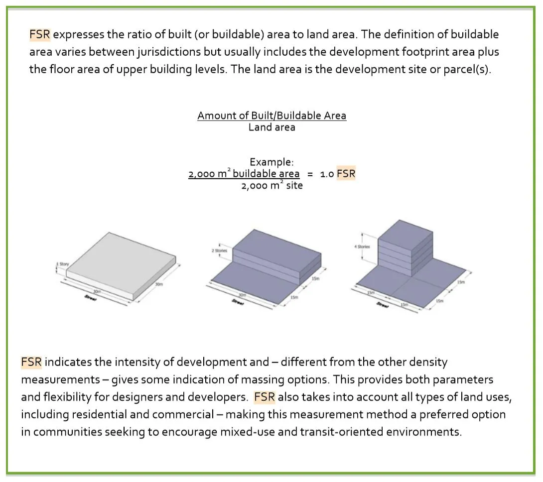
The following illustrations are from our Official Community Plan and Zoning Bylaw. Floor space ratio provide a direct connection between the size of the lot and the amount of floor area that can be built on that lot. It is expressed as a ratio between floor area and lot area. We use it because it allows buildings that are proportional to the size of the lot. It also provides flexibility in terms of the range of unit sizes that are possible on a site which results in developments that can accommodate a broad range of people who have different needs for space and different levels of affordability.
From the Official Community Plan:
From the Zoning Bylaw:
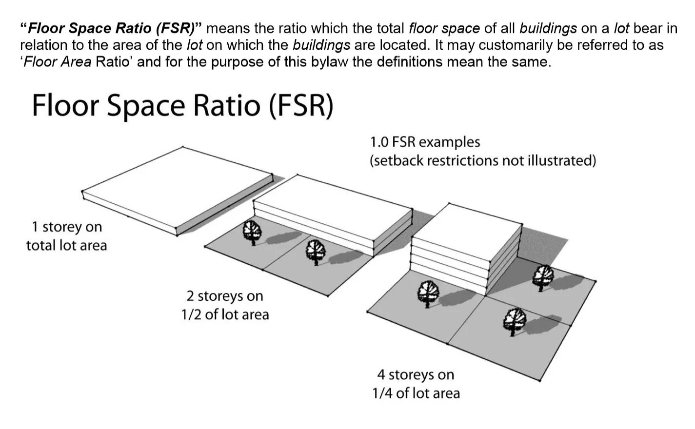
What these illustrations don’t show is the impact of setbacks and building height limits on the actual site. As an example, in an industrial area with large warehouse type uses, it is very likely that a FSR of 1:1 would result in large single storey buildings with minimal setbacks. But in a Town house development, we want to have yard space and perhaps space for surface or garage parking and driveways so the building increases in height and the footprint is reduced.
B. What other tools complement FSR?
From the zoning bylaw, one of the most significant determinants of how many residential units are built is the ability of a site to meet parking requirements. Assuming that having a range of unit sizes is of benefit to the Town, our parking requirements are tailored to require more parking where there are more bedrooms in attached residential units.
Setbacks and requirements for open site space also influence the development of land and help us meet multiple objectives such as access to outdoor space, recreation opportunities, social connection and cohesion, stormwater management and environmental interests to name a few.
C. Why use FSR as opposed to Units per hectare?
We use FSR as our expression of density because it is more precise and results in buildings that are proportional in size to a lot. It also allows the market to respond to changing family structure and needs by using other tools to help shape the form and character of development and to link land use to transportation through parking requirements.
Units per hectare as a density measure does not encourage mixed housing, with a range of unit sizes to accommodate different family structures and levels of affordability. An example of this is the Thetis Cove zoning that places a cap on the number of residential units in addition to a minimum unit size. As the market changed, larger units have become un-affordable and there is a limited market for them. The only option open to the developer to change this is to go through the rezoning process because density can’t be altered by a development variance permit. Instead of controlling the number of units on a site, FSR controls the amount of floor area. Interestingly, the mass of a building can be exactly the same under both ways of measuring density, however the result is that one building with a mix of large and small units is more likely to meet a range a community objectives under topics such as transportation, housing affordability and choice, and social cohesion.
RECOMMENDATIONS:
That the report from the Director of Development Services titled “Density Measures” be received.
SUBMITTED BY: Lindsay Chase, MCIP, RPP, Director of Development Services
REVIEWED BY: Kim Anema, Chief Administrative Officer
Document Images
(3)