Staff Report: Rezoning Application 2018/06 – 7 Erskine Lane
A comprehensive review of a rezoning application to allow a 70-unit apartment building, addressing density, traffic, and community amenities.
TOWN OF VIEW ROYAL
Planning & Development Report
TO: Committee of the Whole
DATE: September 30, 2019
FROM: J. Chow, Senior Planner
MEETING: October 8, 2019
FILE NO.: 3360-20-2018/06
REZONING APPLICATION 2018/06 – 7 Erskine Lane
RECOMMENDATION:
THAT the September 30, 2019 report from the Senior Planner titled “Rezoning Application 2018/06 - 7 Erskine Lane” be received for information;
AND THAT staff work with the applicant to finalize a suitable community amenity contribution package prior to preparing a rezoning bylaw for consideration.
CHIEF ADMINISTRATIVE OFFICER’S COMMENTS: I concur with the recommendation.
DIRECTOR OF DEVELOPMENT SERVICES’ COMMENTS: I concur with the recommendation.
DIRECTOR OF ENGINEERING’S COMMENTS: I concur with the recommendation.
DIRECTOR OF PROTECTIVE SERVICES’ COMMENTS: I concur with the recommendation.
PURPOSE:
This report follows up on an application to rezone the subject property from A-3: Rural Residential to RM-3 (Mixed Residential) for multifamily use. The proposal was introduced to the Committee of the Whole on July 10, 2018 and discussed further at the February 19, 2019 Council meeting. The outstanding issues relate to density, traffic, on-street parking, emergency vehicle access, and community amenities.
BACKGROUND:
The 5288m² subject property was the site of a boat yard for over 50 years and an abattoir for nine years before that. There is a rocky high point with a few trees near the midpoint of the east property line. Aside from a row of trees along the front lot line, the rest of the property has been highly disturbed and contains fill that requires remediation and removal. A Provincial Site Profile release has been issued for independent remediation under the Provincial Contaminated Sites Regulation.
Surrounding land uses include:
- A 2.1ha detached residential property zoned A-1 (Rural) at 9 Erskine Lane to the northwest that is largely treed.
- A 2.6ha vacant quarried property zoned C-1 (Community Commercial) and P-2 (Local Institutional) at 2 Hospital Way to the northeast. The property is eight metres lower and a boulder wall supports the subject property at the shared property line.
- A 4200m² detached residential property zoned A-1 (Rural) at 5 Erskine Lane to the southeast.
- A 3100m² detached residential property zoned CD-12 (Erskine Lane) for multifamily use at 10 Erskine Lane across the street to the west.
PROPOSAL:
The proposal is to rezone the subject property from R-1: Detached Residential (Large Lot) to RM-3 (Mixed Residential) to permit multifamily use. The issues to address in rezoning include land use, density, and standards for lot coverage, percentage of impervious surface, building height and building location.
The applicant’s development concept is a stepped four storey 70-unit strata-titled apartment building with underground parking as shown in Attachments 2. The applicant proposes to target BC Building Code Step 2, provide up to ten electric vehicle charging stations, and install a ~280m² rooftop garden. If the rezoning is approved, a development permit would be required to consider the form and character of the development and how it would address the zoning requirements, including building height, massing, and parking.
DISCUSSION:
Outstanding issues include the following:
- Density
- Traffic impacts
- On street parking and emergency vehicle access
- Community amenities
1. Density
The site is in the Hospital Neighbourhood Centre and is bordered by vacant and developable land an area where Official Community Plan policies specifically encourage higher density in order to create a transit-oriented community. The latest example of this evolution is late night bus service on Fridays and Saturdays on Transit Route 14 (Vic Gen / UVic) ending with 2 a.m. departures and 3 a.m. arrivals at the hospital. This extended service began in September 2019. In principle, the addition of more intensive mixed uses in this area can spur further transit improvements and help reduce automobile dependence for residents, workers, and hospital clientele. The key OCP policy to consider is the following:
Policy LU11.2 Hospital Neighbourhood Centre Explore possibilities for developing a transit-oriented Hospital Neighbourhood Centre on the land immediately west of the Victoria General Hospital and abutting the planned regional rapid transit stop.
Development in the Hospital Neighbourhood Centre should be carefully reviewed to consider the following:
- Uses and development forms that benefit from and support the Victoria General Hospital.
- Potential economic development opportunities that exist in proximity to the hospital.
- Appropriate land uses and densities for supporting transit use.
- Location and design of parking facilities to minimize surface parking and promote a safe and enjoyable pedestrian environment.
- Access and circulation.
- Logistical and engineering issues related to the transit stop and right-of-way.
- Quality of the built environment.
- Connections to planned hospital rapid transit stop, Galloping Goose Regional Trail, Trans-Canada Highway and established residential area east of Helmcken Road.
- Potential noise, light, smell and nuisance issues related to the site’s proximity to VGH, the laundry facility and the Trans-Canada Highway.
Other policy considerations that were presented in previous reports are found in Attachment 3. The property is one of several in this area within the ‘Intensive Mixed Use’ OCP land use designation. The designation supports commercial uses, townhouses and low rise apartments up to five storeys with a maximum floor space ratio of 2.5:1. The proposed RM-3 (Mixed Residential) zoning designation (Attachment 4) and the development concept would be in keeping with the objectives of the land use designation as follows:
| Intensive Mixed Use (Policy LU1.5) | Proposal | |
|---|---|---|
| Floor Space Ratio | 2.5:1 | 1.6:1 (RM-3 zone) 1.3:1 (Development concept) |
| Storeys | 5 | 4-5 (Development concept) |
The development concept to be finalized at the development permit stage is for 70 units on 5288m², which is 132.4 units per hectare. In comparison, the Maija London at 280 Island Highway (the former View Royal Fire Hall site) is also zoned RM-3 with a floor space ratio of 1.6:1 and is comprised of 37 units on 1677m², which is 220.6 units per hectare.
2. Traffic Impacts
The initial transportation impact assessment (Attachment 5) projects that the proposed development would maintain the Watkiss Way/Erskine Lane intersection’s current Level of Service (LOS) A and B as shown in Figures 1 and 2. LOS A and B are defined in Table 1, noting that Watkiss Way traffic has the right-of-way and there are stop signs for vehicles from Erskine Lane and Stoneridge Drive. No mitigation measures are required at the intersection resulting from this development.
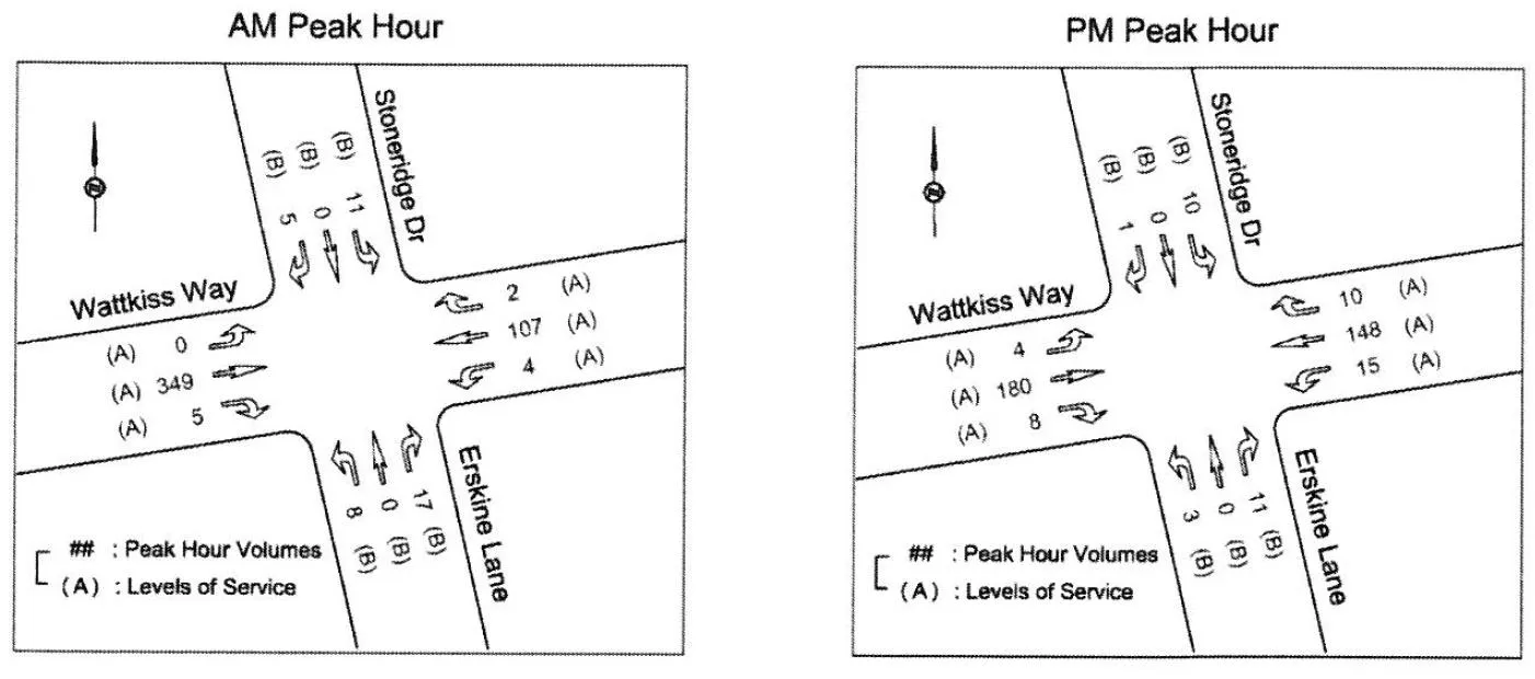
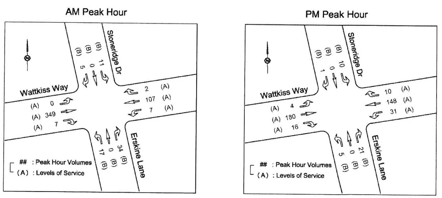
Table 1.
| Level of Service | Unsignalized Intersection |
|---|---|
| A | ≤10 sec |
| B | 10–15 sec |
| C | 15–25 sec |
| D | 25–35 sec |
| E | 35–50 sec |
| F | >50 sec |
| Source: Highway Capacity Manual (Transportation Research Board et al.) |
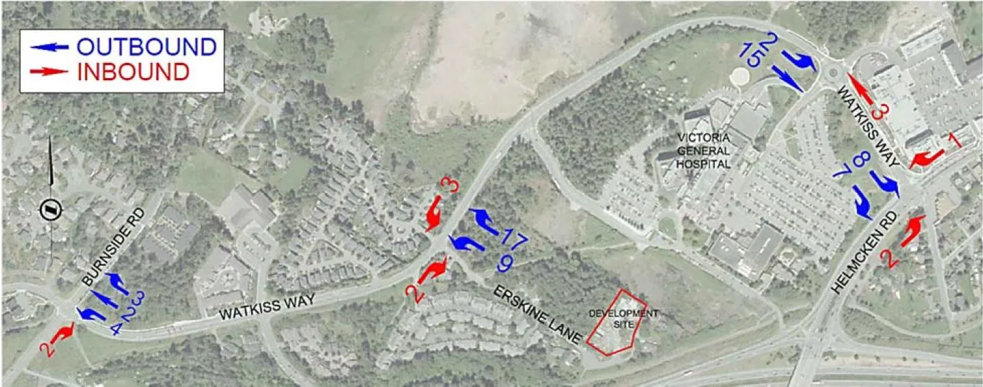
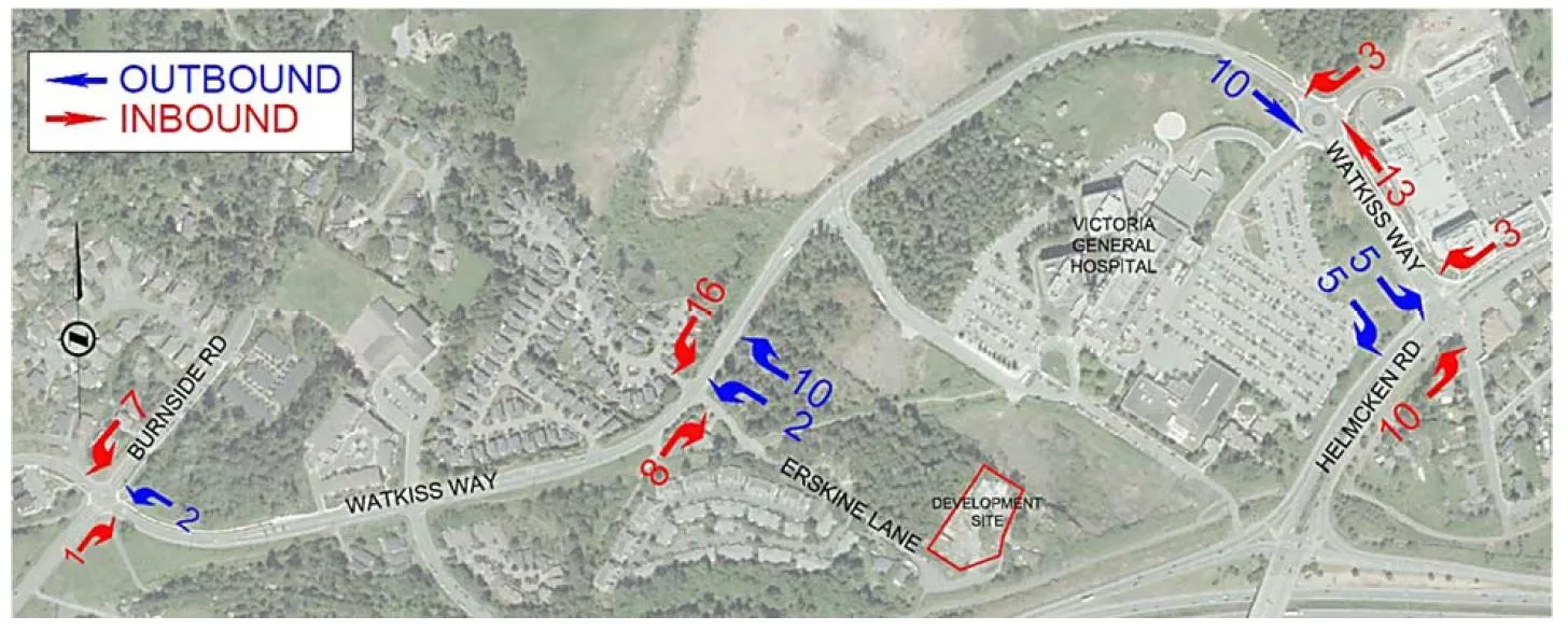
The applicant provided a wider ranging Traffic Impact Assessment Addendum (Attachment 6) that examines the additional traffic from this development at the following nearby intersections as shown in Figure 3 (AM peak hour) and 4 (PM peak hour):
- Watkiss Way/Burnside Road West (signalized 2018)
- Watkiss/VGH-Eagle Creek Village access
- Watkiss/Helmcken Road intersection.
Sections 2 and 3 of TIA Addendum (Attachment 6) project provide further details on long term impacts from the development. The additional traffic impact on congestion at those intersections is insignificant.
3. On Street Parking and Emergency Vehicle Access
There is currently space for four vehicles along the frontage of the subject property and the cul-de-sac currently meets emergency vehicle turning requirements. To address neighbourhood concerns about increased residential demand for on street parking, the applicant proposes a parking bulb at the end of Erskine Lane as shown in Figure 5. The bulb would provide eight parking spaces for a net increase of four spaces. The cul-de-sac radius would be expanded to meet emergency vehicle access requirements. The Engineering Department has reviewed Figure 5 and has no objection to the parking bulb concept.
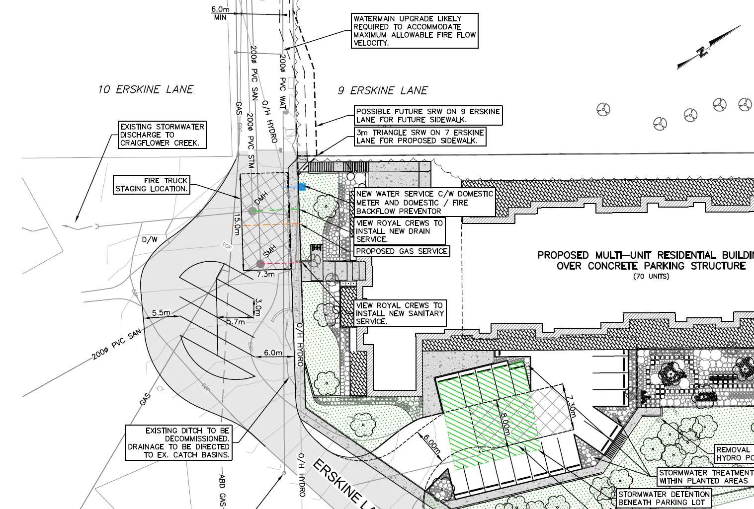
Dedication of a three-metre triangle is required to provide space for the sidewalk to tie into to the future sidewalk on the 9 Erskine frontage. Without the dedication the continuity of the sidewalk would be blocked by a BC Hydro kiosk.
4. Community Amenities
The principles of Official Community Plan Policy LU1.6 “Community Amenities” encourage the provision of community and neighbourhood amenities associated with new development. A revised offer has been presented.
Original offer The original offer of community amenities was for the following: a. A $98,000 260m asphalt walkway from the subject property to Watkiss Way b. A $37,600 cash contribution in support of affordable housing c. 50% of a $290,000 260m water main replacement
Staff does not regard the water main replacement as a community amenity because the Capital Regional District Integrated Water Services does not require replacement or additional capacity. The water main upgrade would be an alternative to constructing firewalls in the proposed building. Excluding the water main replacement, the value of the initial community amenity contribution is $134,899.20 / 70 units = $1,927.66 per unit.
May 2019 offer The current offer (Attachment 7) is for the following: a. A $98,000 cash amenity. Council can choose how to allocate the funds, however if improvements are desired at the Watkiss/Erskine intersection, funds could be directed towards things as crosswalks or something more comprehensive, noting that further improvements could be provided by the potential development of 9 Erskine Lane, depending on traffic impacts. The initial Transportation Impact Assessment identified bus stop shelters on Watkiss Way as a possible community amenity contribution. b. A $37,600 cash contribution in support of affordable housing. As the Town does not have it’s own affordable housing program, it is anticipated that these funds will be passed on to the Regional Housing Trust Fund as an additional contribution. c. A parking bulb with a net increase of four on-street parking spaces, which requires expansion of the current turning area. The additional on-street parking spaces are not a development requirement; however, they benefit both the neighbourhood and the subject property. Staff values the additional four parking spaces at $20,000 total.
The community amenity contribution would be $155,600 / 70 units = $2,222.86 per unit while the Community Amenity Contribution Policy target is $3,500 per multifamily residential unit. This rezoning application was submitted prior to adoption of the policy in June 2019; however, staff is trying to work towards a contribution closer to the target (there was no target previously) and seeks direction from Council for further negotiation with the applicant. The difference between the applicant’s offer and the policy is $89,400. Staff recommends that Council indicate to the applicant that the proposed contribution does not meet the policy. The target of $3500 per unit was established with regard to other municipalities in the region because community amenity contributions have been inconsistent in the past, as shown in Table 2.
Table 2. Community Amenity Contributions for Multifamily Development
| Project | Amenity | Total Units | Amount per Unit | Estimated amenity value |
|---|---|---|---|---|
| Christie Point 2861 Craigowan Road July 2017 |
CRD Regional 1. Affordable Housing Trust Fund 2.Tenant relocation support package 3. Transportation improvements |
~473 | $5,180 | 1. $750,000 2. $850,000 3.+$775,000 $2,375,000 |
| Thetis Lake Campground 1938 West Park Lane |
5.12 ha Mill Hill parcel | ~350 | $3,080- $7,142 | $1,078,000 Assessed value ($2,500,000 Purchase price) |
| Avanti townhouses 1342 Trans Canada Highway (St. Giles St.) |
Park improvement contribution 82m walkway Road and drainage improvements |
22 | $6,912 | $15,000 $22,000 +$115,070 $152,070 |
| 4 Mile Estates townhouses 235 Island Highway |
Park improvement contribution | 24 | $1,500 | $36,000 |
| “The Glen” 105-108 Glentana Rd |
260m trail with vehicle access and some fencing | 46 | $544 | $25,000 |
NEXT STEPS:
It is recommended that staff work further with the applicant to provide a suitable amenity contribution package that is more in keeping with the Community Amenity Contribution Policy. If there is no agreement, staff recommends that a land lift analysis be conducted.
The final amenity contribution package along with the road dedication would be secured in a covenant to be registered concurrently with fourth reading if not provided before. If the commitment to Building Code Step 2, provision of electric vehicle charging stations, and 280m² of rooftop gardens are essential to Council’s approval of the land use, those could also be included in the covenant.
Ministry of Transportation and Infrastructure approval will be required for a rezoning bylaw in this location.
RECOMMENDATION:
THAT the September 30, 2019 report from the Senior Planner titled “Rezoning Application 2018/06 - 7 Erskine Lane” be received for information;
AND THAT staff work with the applicant to finalize a suitable community amenity contribution package prior to preparing a rezoning bylaw for consideration.
ATTACHMENTS
- Location plan
- Development Concept excerpt – VDA Architecture Ltd., May 1, 2018 (6 pages)
- Official Community Plan review (2 pages)
- Zoning Bylaw No. 900, 2014 excerpt: RM-3 Zone: Mixed Residential (2 pages)
- Transportation Impact Assessment – Watt Consulting Group, January 3, 2018 (13 pages)
- Traffic Impact Assessment Addendum – Watt Consulting Group, November 23, 2018 (24 pages)
- Letter from Applicant, May 29, 2019 (4 pages)
Document Images
(4)