Phase I ESA: Helmcken Rd & Burnside Rd W, View Royal, BC
A Phase I Environmental Site Assessment conducted by McElhanney for several properties to identify potential environmental concerns prior to redevelopment.
Executive Summary
McElhanney Consulting Services Ltd. (McElhanney) was retained by the Highstreet Ventures Inc. (the Client) to conduct a Phase I Environmental Site Assessment (Phase I ESA) for several properties located near the intersection of Helmcken Road and Burnside Road West in View Royal, BC (the Site). A comprehensive review of historical records was completed for the Site and surrounding adjacent properties. Visual observations were made of land at and adjacent to the Site.
The Site was first developed in the 1940s and land use at the time included a single residential home and cattle pasture/agricultural land. The Site and neighbouring land to the north and east have been owned and occupied by the Henson family since the 1950s. Additional single-family residential homes were built in the 1950s and 1960s. The Henson family also constructed and managed a 12-unit apartment building on-Site in 1970. Members of the Henson family continue to reside in several homes in the area but primarily rent the residencies on the Site to various tenants.
The Henson family has also operated contracting businesses on the Site. The first was Henson W Building Contractors which owned by William Henson and operated out of the home at 1449 Burnside Rd W from around 1969 to the mid-1970s. The business then moved to a newly constructed home at 1480 Burnside Rd W (north of the Site) and was in operation until the early 1990s. The second contracting business is owned and operated by Julie and Robert Henson (J&R Henson Construction Ltd). For a period, they operated a plant nursery on the Site (circa 2005). The business also brought soil materials onto the northwest portion of the Site to be segregated and reused in landscaping (i.e. top soils, field stones and woody debris were separated on Site into various stockpiles).
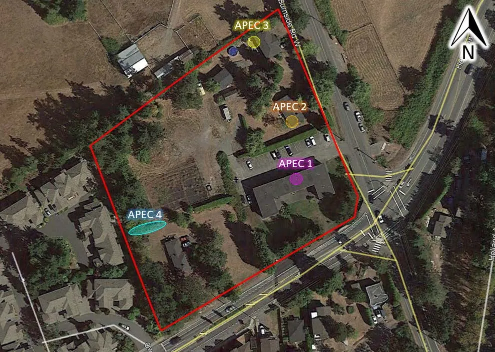
It is McElhanney’s opinion that, based on the findings of this Phase I ESA, historical and current activities present a potential risk of impacting environmental media at the Site and further environmental investigation is warranted. Based on our assessment of the Site, four areas of potential environmental concern (APEC) were identified that require further investigation and is presented in the below table and figure summarized from the text.
Table: Areas of potential environmental concern
| Area of Potential Environmental Concern | Description |
|---|---|
| APEC 1 | #3 Helmcken Rd Approximately 1000 L heating oil tank. Small stains noted under the tank, gravel floor is directly adjacent to the AST providing a pathway for potential contamination to enter the subsurface. |
| APEC 2 | 1445 Burnside Rd W abandoned home heating oil AST in the crawlspace on the southwest corner of the building (size could not be determined, but greater than 1000L) |
| APEC 3 | 1449 Burnside Rd W 1000 L heating oil tank located on the northwest corner of the building. The original tank was leaking as was replaced with the current tank. |
| APEC 4 | #5 Helmcken Rd poor housekeeping in the yard to the north of the house included disposal of a kerosene container, a 205 L steel drum of unknown contents and several other chemical containers inferred to be for lawn care and/or general home maintenance. |
Staff Recommendations: A limited Phase II Environmental Site Assessment (Limited Phase II ESA) is recommended to quantitatively assess surficial soils at the identified APEC locations. The collected soil samples would be analyzed by an accredited laboratory. Potential contaminants of concern will be determined during the planning stages of the Phase II ESA.
Table of Contents
- Introduction.................................................................................................................................................... 1
- Assessment Methodology........................................................................................................................... 4
- Records Review ........................................................................................................................................... 5 3.1 Environmental Setting .........................................................................................................................5 3.1.1 Precipitation ............................................................................................................................................ 5 3.1.2 Water Resources..................................................................................................................................... 5 3.1.3 Surficial Geology ..................................................................................................................................... 6 3.2 Previous Environmental Reports.........................................................................................................7 3.3 ERIS Ecolog Database Searches .......................................................................................................7 3.3.1 Database Results within 250 m of Site Boundaries................................................................................. 8 3.3.2 BC Ministry of Environment & Climate Change Strategy Site Registry Search....................................... 8 3.3.3 Fire Insurance Plans ............................................................................................................................... 8 3.4 Aerial Photograph Interpretation .........................................................................................................8 3.5 Civic Directories ................................................................................................................................10
- Site Visit.......................................................................................................................................................12 4.1 Property Description..........................................................................................................................12 4.1.1 Topography, Fill Areas, and Local Geology .......................................................................................... 12 4.1.2 Buildings and Structures ....................................................................................................................... 13 4.1.3 Services and Utilities ............................................................................................................................. 13 4.1.4 Heating and Cooling Systems ............................................................................................................... 14 4.1.5 Mechanical Equipment.......................................................................................................................... 14 4.1.6 Underground Storage Tanks ................................................................................................................. 14 4.1.7 Above Ground Storage Tanks............................................................................................................... 14 4.2 Exterior Observations........................................................................................................................15 4.2.1 Surface Staining and Site Vegetation.................................................................................................... 15 4.2.2 Pits, Lagoons, Waste Water and Liquid Discharges.............................................................................. 15 4.3 Hazardous Materials and Special Attention Items ............................................................................15 4.3.1 Radon.................................................................................................................................................... 16 4.3.2 Polychlorinated Biphenyls (PCBs)......................................................................................................... 16 4.3.3 Chemical Storage Containers ............................................................................................................... 16 4.4 Neighbouring Properties ...................................................................................................................16 4.5 BC CSR Schedule 2 Activities ..........................................................................................................17
- Interviews ....................................................................................................................................................17 5.1.1 Mr. Robert Henson................................................................................................................................ 17 5.1.2 Eddie Trembay...................................................................................................................................... 17 5.1.3 Tracy Bruno........................................................................................................................................... 18
- Summary and Conclusions.......................................................................................................................18
- Limitations of Report..................................................................................................................................19
- Professional Statement .............................................................................................................................21
Tables
Table 1. General Site Information............................................................................................................................3 Table 2. Aerial Photograph Interpretation................................................................................................................8 Table 3. Neighbouring Properties ..........................................................................................................................16 Table 4. Areas of potential environmental concern ...............................................................................................18
Figures
Figure 1. General Site Location (orange arrow) at Helmcken Road and Burnside Road W, View Royal, BC..1 Figure 2. Approximate Site Boundary (red outline) in View Royal, BC (ortho courtesy of Google Earth). Lots are outlined in yellow and civic addresses are bolded..............................................................................................2 Figure 3. BC ENV Water Resource Atlas 500 m radius search results (iMapBC 2018)...................................6 Figure 4. Excerpt from Relevant Soil Map of Vancouver Island – Victoria Saanich Sheet (BC6_map4) from Agriculture and Agri-Food Canada. ..........................................................................................................................7 Figure 5. Civic addresses at the Site and surrounding areas used in the public directory search .................11 Figure 6. Soil segregation activities historically occurring on the northwest portion of the Site.......................13 Figure 7. Areas of potential environmental concern.........................................................................................19
Appendices
A Select Site Photographs B Select Aerial Photographs C Land Titles D ERIS Ecolog Database Search Results E Opta Fire Insurance Records F Vancouver Public Library Civic Directories
1. Introduction
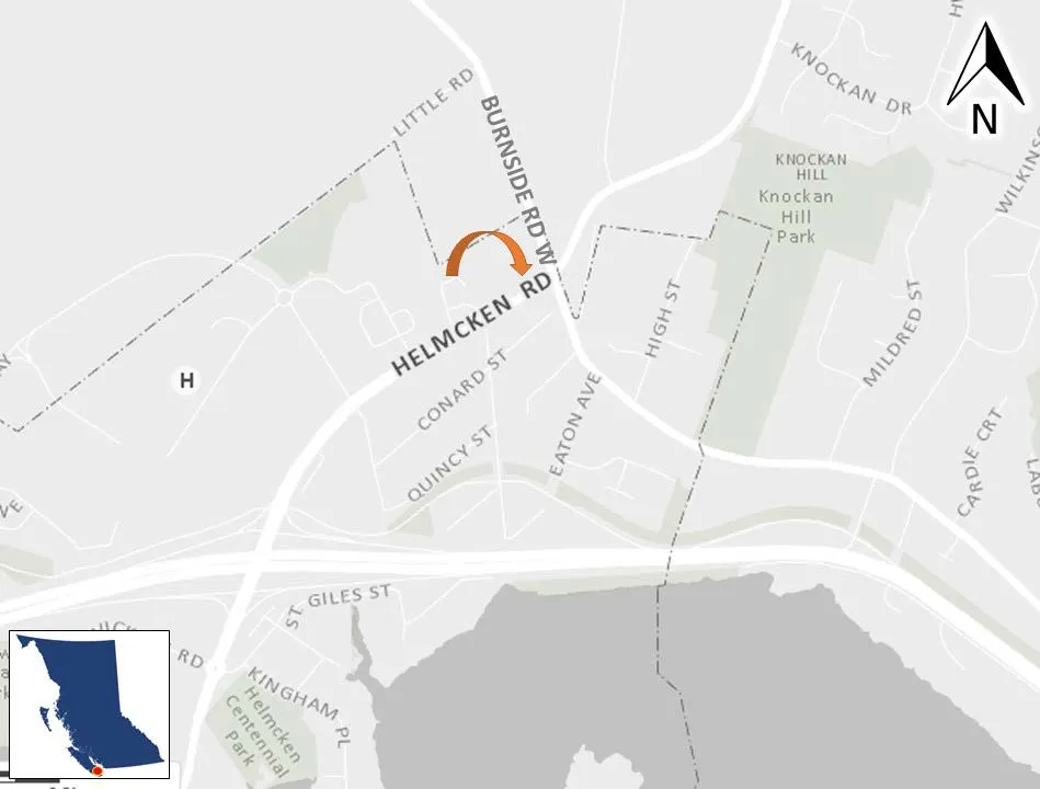
McElhanney Consulting Services Ltd. (McElhanney) was retained by Highstreet Ventures Inc. (the Client) to conduct a Phase I Environmental Site Assessment (Phase I ESA) for several properties located at the intersection of Helmcken Road and Burnside Road West in View Royal, BC (herein referred to as #3 Helmcken Rd or the Site) (Figure 1 & Figure 2). This report presents the findings of the Phase I ESA.
General Property Information
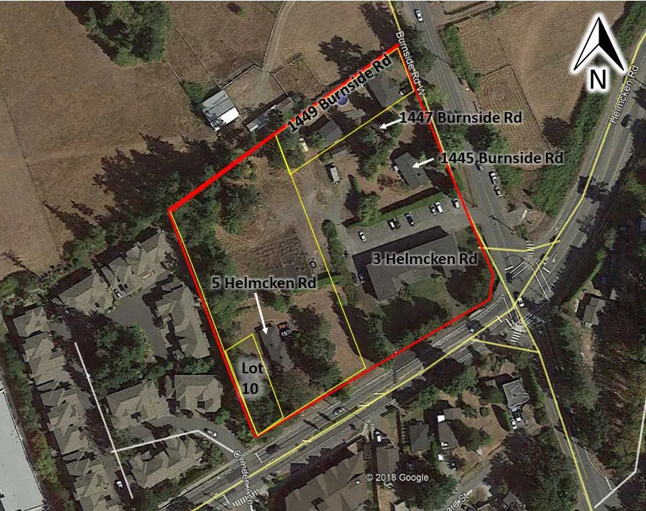
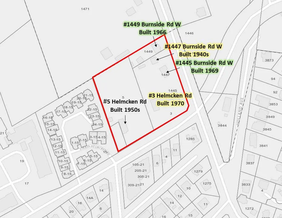
General Site information is summarized below in Table 1. Reconnaissance photographs of the Site and surrounding properties are included in Appendix A. Historical aerial photographs showing past land uses for the area are included in Appendix B. The Site is comprised of four single family residential homes, a twelve-unit apartment building and an area formerly used as a plant nursery. The Site is bounded by Helmcken Road to the south and Burnside Road W to the east. All lots on the Site are currently owned by the Henson family and have been so for multiple generations. Neighbouring properties to the north and east are also owned and occupied by the Henson family. The current land use proposal is to remove all existing buildings for Site redevelopment. Land title information and plans are provided in Appendix C.
Table 1. General Site Information
| Site Civic Address | 3 Helmcken Rd (includes homes with addresses 1445 & 1447 Burnside Rd W) |
|---|---|
| 5 Helmcken Rd | |
| Lot 10 Helmcken Rd | |
| 1449 Burnside Rd W | |
| Legal Description | Lot 1 Plan VIP3963 Section 9 Land District 21 Except Plan 18753 |
| Lot 2 Plan VIP3963 Section 9 Land District 21 | |
| Lot 10, Block 5, Section 9, Esquimalt District, Plan 1726 | |
| Lot 1 Plan VIP18753 Section 9 Land District 21 | |
| Parcel Identifier Number (PID) | 000-295-981 |
| 006-114-946 | |
| 007-028-156 | |
| 000-300-365 | |
| Registered Land Owner | 000-295-981 – Julie and Robert Henson |
| 006-114-946 (5 Helmcken Rd)– J&R Henson Construction Ltd. | |
| 007-028-156 (Lot 10) – J&R Henson Construction Ltd. | |
| 000-300-365 (1449 Burnside Rd W)– Julie and Robert Henson | |
| Occupant | All buildings/homes are currently occupied by tenants |
| Current Use | Residential |
| Area | 1.33 Hectares (3.3 Acres) |
| Zoning | RM-1 (Ground-Oriented Multiple-Unit Residential) R-1 (Detached Residential – Large Lot) |
The current property owner is listed as the Julie and Robert Henson on two of the titles and J&R Henson Construction Ltd. on the other two titles. The entire Site is owned by the Henson family. A copy of the current title search has been provided in Appendix C. All four of the titles were recently registered (between 2016 to 2017) but the Henson family has owned the land since approximately the 1950s, it has transferred ownership through several family members over time.
Site contamination issues, if listed on a title search, are most often found in Section 219 Covenants. A Section 219 covenant was not listed on the current title search for the Site. Leases, title transfers or easements related to site contamination issues were absent in the current title search results.
2. Assessment Methodology
The scope of this assignment was to conduct a Phase I ESA in accordance with CSA Standard Z768-01 (Reaffirmed 2016). The objective of this Phase I ESA was to determine whether Areas of Potential Environmental Concern (APECs) are present at the Site due to current and/or historical on and off-site activities. The study was completed to qualitatively identify the risk of actual or potential contamination of environmental media (soil, surface water, groundwater or soil vapour) on or adjacent to the Site.
The following rationale was applied throughout the assessment to determine whether current or historical activities represent a potential environmental concern for the Site:
- BC Contaminated Sites Regulations (CSR) Schedule 2 Activities for commercial or industrial sites identified on or adjacent to the Site;
- The presence of a hazardous substances (including waste) storage or use on-Site;
- Indication that substances were inadequately handled or contained and a pathway to the receiving environment may be present;
- The use, storage, or handling of a substance of potential concern occurred consistently over a long period of time, or in sufficient quantities to be considered a potential concern; and
- Are identified off-site land uses of concern located in close enough proximity and topographic orientation to present a potential for the migration of contamination onto the Site.
The following specific tasks were undertaken:
- Review of relevant records including: historical environmental reports; a search of relevant Provincial and Federal databases; available fire insurance maps; and available historic aerial photographs for the Site;
- Completion of a site visit to review and document existing conditions of the Site and surrounding area;
- Interviews with individuals knowledgeable of Site conditions;
- A review of the current land title for items related to site contamination issues (most often found in Section 219 Covenants, and certain lease, title, easement information); and
- Preparation of this report documenting the findings, summarizing recommendations (if any) and stating the limitations of this study.
The findings contained in this Phase I ESA are partly based on information provided by others. Where possible, information obtained through interviews was cross referenced through other sources.
Sampling and analysis of environmental media (soil, groundwater, surface water, or soil vapour) was not undertaken as part of this study. The assessment included a search of regulatory databases as defined in Section 4. Searches included properties bordering all extents of the Site.
3. Records Review
Several historical records were reviewed to assess the environmental conditions and current or historical land use activities at the Site. The following sections summarize the findings of this review.
3.1 ENVIRONMENTAL SETTING
3.1.1 Precipitation
Climatic conditions at the Site were inferred based on data provided by Environment Canada, Canadian Climate Normals 1981-2010. Recorded precipitation data for the Victoria Francis Park station were considered representative of the Site based on their proximity to that station. Annual precipitation was 1029.3 mm with monthly average lows of 19.3 mm in July and highs of 204.2 mm in November.
3.1.2 Water Resources
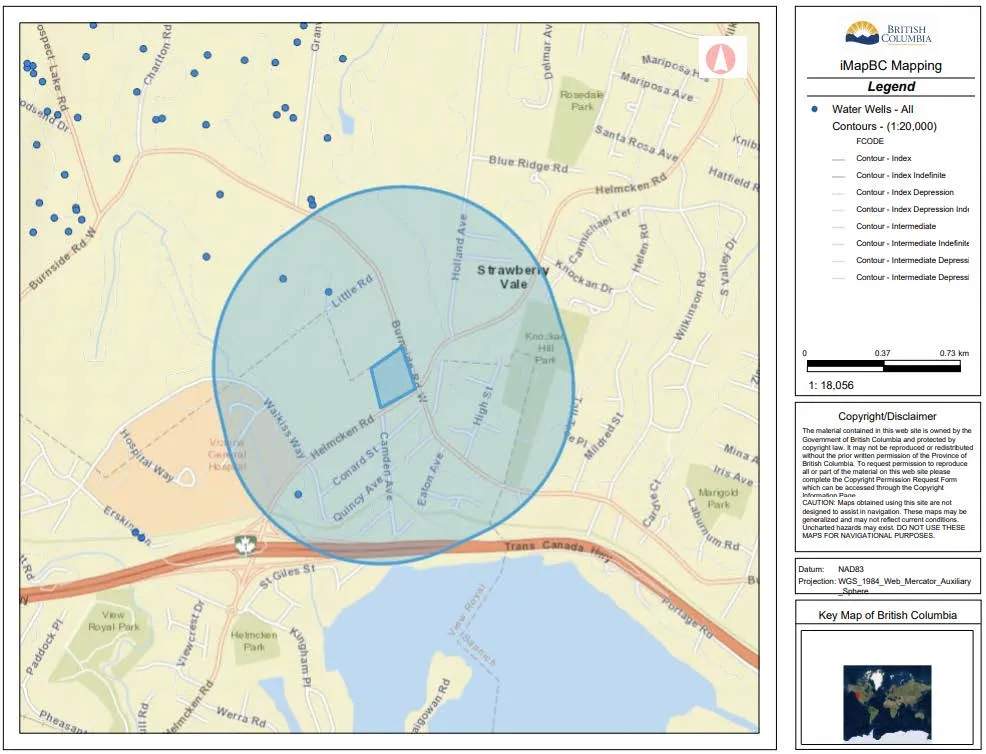
The iMapBC Water Resources layer, which is maintained by the Ministry of Environment & Climate Change Strategy (ENV), was used to create a map (Figure 3 below) depicting local topography, known water well locations, and surface water within a 500 m radius of the Site. This figure was used to infer groundwater flow direction.
Portage Inlet is located approximately 500 m south of the Site. Three water wells were identified within the 500 m search radius of the Site. The closest well (Well Tag # 34554) is 250 m north northwest of the Site and was constructed in 1976. Groundwater in this location was encountered at 41 meters below ground surface (mbgs).
Local topography suggests that the Site is on undulating ground which is approximately 30 m above sea level (masl). There is a hill to the east of the site in the area known as Strawberry Vale the summit of the hill is approximately 75 masl. There is a low point to the northwest of the Site with an elevation of approximately 14 masl. Based on the available information the groundwater flow direction is assumed to be south towards the Portage Inlet. Note that an intrusive Site-specific assessment of groundwater would be required to calculate actual groundwater flow direction.
3.1.3 Surficial Geology
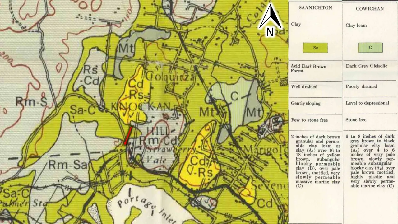
Soil Survey Reports for British Columbia are published by Agriculture and Agri-Food Canada. Available soil survey reports and maps for British Columbia were reviewed to determine surficial geology and soil types at the Site. Map 4-1959 Soil Map of Vancouver Island British Columbia – Victoria – Saanich Sheet was reviewed. The Site was classified as Saanichton-Cowichan soils which are clay to clay loam soils which are developed on fine-textured marine materials (Figure 4).

3.2 PREVIOUS ENVIRONMENTAL REPORTS
No previous environmental reports are known, and no reports were provided to McElhanney for review.
3.3 ERIS ECOLOG DATABASE SEARCHES
EcoLog Environmental Risk Information Services (ERIS) was retained to perform a 500 m search radius (from the edge of the Site) of the BC Ministry of Environment & Climate Change Strategy Site Registry (Site Registry) and a 250 m radius search of several additional environmental inventories and databases. The Site Registry is a data repository maintained by the BC ENV under the provisions of the Environmental Management Act (EMA) and Contaminated Sites Regulation (CSR) regarding information on activities with contamination causing potential.
It should be noted that ERIS provides a general database report which contains the most current information available for the databases reviewed. However, when registered sites are identified, an additional detailed site registry report is generated by ERIS which only provides information listed on the registry until 2012. To address the data gap between 2012 and the date of this assessment, BC Online was used (as necessary) to obtained detailed reports for relevant registered sites identified in the investigation.
3.3.1 Database Results within 250 m of Site Boundaries
There were no database listings for the Site property or the 250 m surrounding areas of the Site. There were no historical activities of concern identified through a review of historical databases. A copy of ERIS search results is provided in Appendix D.
3.3.2 BC Ministry of Environment & Climate Change Strategy Site Registry Search
There were no listings for the Site property or the surrounding area within the 500 m search radius.
3.3.3 Fire Insurance Plans
Historical fire insurance maps may provide insight into historical activities of a Site and they may document underground storage tanks or historical Site usage that may warrant environmental concern and/or further investigation. A search for available Fire Insurance Maps was conducted through ERIS/Opta. Fire insurance search results are provided in Appendix E. Results indicated that no fire insurance records were available for the Site area.
3.4 AERIAL PHOTOGRAPH INTERPRETATION
Historical aerial photographs were obtained from UBC’s Geographic Information Center and images from Google Earth. A selection of photographs available for review from the following years; 1932, 1946, 1956, 1968, 1974, 1980, 1986, 1997, 2005, 2010, 2014 and 2017. A summary of our review has been presented in Table 2 and copies of selected aerial photographs with a detailed review are provided in Appendix B.
Table 2. Aerial Photograph Interpretation
| Year | Photograph Reference | Site Area | Adjacent Properties |
|---|---|---|---|
| 1932 | A 4517 66 | The Site was primarily forested with the southern portion cleared along Helmcken Rd. | Helmcken Rd bound the Site and ended where it intersected with the Burnside Rd W at the southeast corner of the Site. Both roads appeared to be single lane gravel roads. There was agricultural land to the east, south and west. The property directly to the east had a single-family home and a dairy barn. |
| 1946 | BC 245 76 | Most of the forested vegetation had been removed and the Site converted to agricultural land. Near the northeast corner a single family home was visible which currently is at address 1447 Burnside Rd W. | A few rural residential homes were visible to the south and both Helmcken Rd and Burnside Rd W had been upgraded. Holland Ave had been constructed to the east of the neighbouring barn. |
| 1956 | BC 2042 63 | The property appeared to have been subdivided with a hedge or fence running through the center (north south). A second single family residential home was visible on the southwest corner (5 Helmcken Rd). | Conrad Street had been constructed to the south. Holland Ave had been paved. Residential development had increased to the south. |
| 1968 | BC 5284 153 | The residential home at 1449 Burnside Rd W. on the northeast corner had been built. The home at 1445 Burnside Rd W was under construction. | The lot to the north had a residential home and a building consistent with a barn directly adjacent to the northern boundary. |
| 1974 | BC 5568 0082 | The apartment building on the southeast corner of the Site was visible (#3 Helmcken Rd). A third residential home had been built along the east of the Site off Burnside Rd W (1445 Burnside Rd W). To the west of the houses was a building consistent with a shed. | Observations were like 1968. |
| 1980 | 15 BC 80005 272 | A structure consistent with a shed had been removed and a building had been constructed on the north central part of the Site. | Helmcken Rd and Burnside Rd W had been upgraded and widened. |
| 1986 | FF 8606 70 | Observations were like 1980. | Helmcken Rd had been extended to the east, cutting off Holland Ave. The barn to the east had been removed to allow the road expansion. |
| 1997 | 15 BCB 97005 14 | Observations were like 1986. | Observations were like 1986. |
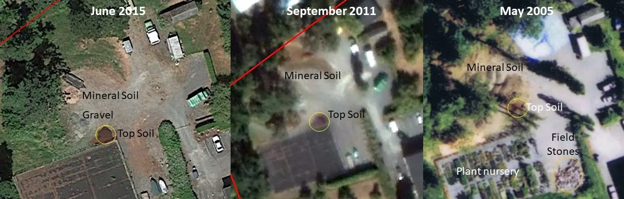
| 2005 | ME 05 439C 0093 | On the northwest quarter of the Site, stockpiles of soil were visible. To the south of the stockpiles there was a new paved pad which was consistent with a commercial garden center or nursery. Bounding the garden boxes was a new paved or graveled parking area in the center of the Site. There was a stockpile of debris in the center of the Site on the new parking lot. | The property to the west had been redeveloped to a high density residential development. |
| 2010 | Google Earth | The plant nursery was removed, and a geo synthetic lined fabric pad remained. | to the south of Helmcken single family residential homes had been demolished and were being redeveloped. |
| 2014 | Google Earth | Observations were like 2010. | To the west a large commercial development was under construction. |
| 2017 | Google Earth | Observations were like 2014. | The commercial development to the west was complete. |
Based on the review of available aerial photographs, the historical Site and surrounding property land usage is not considered an environmental concern at this time.
3.5 CIVIC DIRECTORIES
A search of historical local property uses was conducted by the City of Vancouver Public Archives, and available directories from the years 1910-1999 were reviewed. The City of Vancouver Public Archives civic directories search results are presented in Appendix F. Figure 5 below depicts the buildings on-Site and the in the surrounding areas. It should be noted that the CRD webmap tool (used to create the figure) had incorrectly plotted the civic addresses for the houses at 1447 & 1445 Burnside Rd W.
The following listings for the Site gives an approximate time frame for which the houses/residences were first constructed:
- 5 Helmcken Rd was first listed in the directories in 1954 and visible first in the 1956 aerial photograph which indicates it was constructed in the early 1950s,
- 3 Helmcken Rd (the Robalee Apartments) were first listed in the 1974 directories, anecdotal information indicates that the apartment building was constructed in 1970,
- 1445 Burnside Rd W the house was listed as a “new house” in the 1969 directory and anecdotal information indicated that it was constructed around 1969 to 1970. The 1968 aerial photograph shows that construction was underway on the house,
- 1447 Burnside Rd W is the original house on the property which was first listed in the 1959 directories. This home was first visible on the 1946 aerial photograph. It should be noted that the block numbers change in the directory in 1945, which makes interpreting the information from the directories prior to 1949 difficult,
- 1449 Burnside Rd W first shows up on the 1969 directory listed as Henson William Building Contractor. It is first visible in the 1968 aerial photograph and Robert Henson indicated that it was constructed around 1966. The house at this location was originally listed as the location of the family business until the mid-1970s. In 1979, Henson W building contractors moved to the residence to the north at 1480 Burnside Rd W where it remained until the last directory listing. The Robalee Apartments were constructed 1969-1970 by the Henson family, thus it is inferred that the business at 1449 Burnside Rd W was related to the construction of the apartment building.
McElhanney also reviewed the directories for the surrounding area. Primarily the listings were for residential properties and businesses associated with rural residential communities such as a plant nursery, a dairy farm, grocery and general stores, churches, and a few general contractors. No listings for the Site or surrounding areas were of environmental concern to the Site.
4. Site Visit
McElhanney personnel conducted a Site visit on February 24th, 2018. Field reconnaissance was limited to visual and olfactory observations. The following sections summarize observations. Select Site photographs captured during the Site visit are presented in Appendix A.
4.1 PROPERTY DESCRIPTION
The Site was first developed in the 1940s and land use at the time included a single residential home and cattle pasture/agricultural land. The Site and neighbouring land to the north and east are currently owned by the Henson family. Information obtained in a review of the public directories as well as anecdotal information provided by Robert Henson indicates that the Henson family has owned and occupied buildings on the Site and neighbouring properties since approximately the early 1950s.
Additional single-family residential homes were built in the 1950s and 1960s. The Henson family also constructed and managed a 12-unit apartment building on-Site in 1970. Members of the Henson family continue to reside in several homes in the area but primarily rent the residencies on the Site to various tenants.
The Site is bounded by Helmcken Rd to the south and Burnside Rd W to the east. The surrounding neighbouring property use was identified as mainly residential to the south and west. Land use to the north and east are agricultural. There was a dairy farm historically located to the east of the Site. Mr. Robert Henson now resides in a home to the east of the Site where he has some cattle which use the lot for grazing.
4.1.1 Topography, Fill Areas, and Local Geology
Imported fill presents environmental concern if the quality of fill is unknown. The general Site topography was undulating with a rocky outcrop on the west of the Site. On the southeast corner of the Site there is a retaining wall and the intersection of Helmcken Rd and Burnside Rd W is approximately 1 m higher than the yard at the Site. This indicates that when the road was upgraded in 1980, fill was brought in within the road right of way.
A large natural hill is located to the southeast of the Site. Despite the undulating and hilly local topography, the regional topography gradually slopes south towards Portage Inlet. According to Mr. Henson, the gravel fill observed in the center of the Site is road-based fill that was put in place as part of the developing the plant nursery in the mid-2000s. Anecdotal information obtained from the land owner, indicated that the area was regraded to develop the plant nursery.
The Henson family has operated contracting companies for over 50 years, currently under the legal name J&R Henson Construction Ltd. As part of business operations, loads of mixed soil/fill materials were deposited on the Site for segregation. The aerial photograph record shows this land use occurring from around the year 2005 until approximately 2016 (as seen in Figure 6).
Mr. Henson indicated that initially some of the soil stockpiles at the Site were generated from regrading the plant nursery area. The photograph record indicates that the soils included woody debris/field stones, mineral soil, and top soil which was confirmed by Mr. Henson during the Site visit. Mr. Henson indicated that the segregated materials were reused in landscaping. Contaminated fills are not suspected to have been placed on the Site, therefore this land use is not considered to be of environmental concern.
4.1.2 Buildings and Structures
At the time of the Site visit, several buildings and structures were present on the Site. There was a total of nine structures which consisted of four single-family residential homes, a twelve-unit apartment building, two detached garages, and a couple of sheds. There is also a large fenced area on the west side of the Site on #5 Helmcken Rd that was formerly used as a plant nursery.
The apartment building is a two-storey, stucco/cedar shake sided building with a tar and gravel roof. The home at 1447 Burnside Rd W has asbestos cement siding. The home at 1449 Burnside Rd W has stucco siding with shingle roof construction. There was concrete/stucco siding with shingle roof at the home on 1445 Burnside R W. The home at 5 Helmcken Rd appeared to be wood shingles with a shingle roof construction.
Several out buildings were on the Site which included a detached garage, some sheds, a shipping container and a weathered Quonset hut made of canvas on a metal frame.
4.1.3 Services and Utilities
The Site is serviced with electricity via BC Hydro. Sanitary and storm water services are provided by View Royal. The Site was connected to the municipal sanitary sewer system in 1980 when the roadways bounding the Site were upgraded. Mr. Henson indicated that the former septic field and tank for the apartment building is in the lawn to the south of the building and were left in place. It is inferred that the homes along Burnside Rd W would have had septic fields in the back yards (to the west of the homes).
4.1.4 Heating and Cooling Systems
The following heating systems were noted during the Site visit:
- 5 Helmcken Rd building is heated via electric baseboards,
- 3 Helmcken Rd building is heated via electric baseboards and the hot water tanks are heated with fuel from an above ground storage tank (AST),
- 1445 Burnside Rd W building is heated via electric baseboards, there is an abandoned home heating oil AST in the crawlspace which is inferred to have been formerly used to heat the house.
- 1447 Burnside Rd W building is heated via electric baseboards,
- 1449 Burnside Rd W building is heated a forced air furnace that is fueled by home heating oil.
4.1.5 Mechanical Equipment.
No mechanical equipment was present on the Site.
4.1.6 Underground Storage Tanks
Underground storage tanks (USTs) have the potential to affect soil and or groundwater if the contents of the UST leak into the surrounding environment or the tank is accidentally spilled during fill up. No indications of USTs were observed on the Site.
In addition, an inquiry regarding the availability of fire insurance maps for the Site was made through ERIS. Historical fire insurance plans are used to identify historical USTs if present on the Site or surrounding properties. No fire insurance plans were available for the Site or surrounding area. A letter response provided by ERIS is included in Appendix F. No evidence of historical USTs was indicated from available historical information.
4.1.7 Above Ground Storage Tanks
The presence of above-ground storage tanks (ASTs) could pose environmental concern if leakage onto underlying soils had occurred. Three home heating oil ASTs were observed on the Site:
- 3 Helmcken Rd 1000 L heating oil tank. Located on the ground-floor and used to heat the hot water tanks. The tank is in relatively good condition but there are a few small stains under the tank. The tank is on a concrete floor but directly adjacent to the tank is a gravel floor. It is inferred that this tank is not the original one and that an older tank would have been replaced with this tank as some point in time. This is an area of potential environmental concern (APEC) to the broader Site,
- 1445 Burnside Rd W abandoned home heating oil AST in the crawlspace which is an APEC for the Site,
- 1449 Burnside Rd W 1000 L heating oil tank. Located on the northwest corner of the building. The original tank was leaking as was replaced with the current tank. This is considered an APEC for the Site.
4.2 EXTERIOR OBSERVATIONS
4.2.1 Surface Staining and Site Vegetation
The presence of stains on road surfaces or porous media such as soil and gravel may be indicative of environmental contamination caused by leaks or spills. Furthermore, stressed vegetation or an absence of vegetation may be regarded as viable bio-indicators for the presence of contaminated environmental media.
The Site was mainly comprised of grass covered lawn, a parking lot, and gravelled surfaces. Recent precipitation on exterior surfaces made it difficult to identify any potentially stained surfaces. In the ground floor of the apartment building there was extensive staining/moisture observed on the concrete and gravel surfaces. Staining was primarily attributed to leaking water tanks and moisture from the ground. There was small staining inferred to be from hydrocarbons under the AST.
In the crawl space under the home at 1445 Burnside Rd W there was staining on the concrete floor, there is an abandoned AST in the area which was not accessible, thus it cannot be concluded if the staining is due to moisture, a leaking tank or a combination of both.
4.2.2 Pits, Lagoons, Waste Water and Liquid Discharges
Pits and lagoons may warrant environmental concern if they are used to collect streams of waste water or liquid waste streams. No pits or lagoons were observed at the Site or on adjacent properties.
4.3 HAZARDOUS MATERIALS AND SPECIAL ATTENTION ITEMS
Hazardous materials listed under the BC Hazardous Waste Regulation (HWR) such as asbestos or lead paint may be present in structures built before 1990. In addition, the BC HWR defines hazardous waste as dangerous goods that are no longer used for their original purpose. These wastes require special consideration for disposal and are commonly produced as part of regular commercial/industrial business operations. Examples of some common hazardous wastes include waste oil, oily rags/filters, used paints/thinners, and spent aerosols.
No hazardous materials were observed during the Site visit. Special attention substances such as asbestos, urea formaldehyde foam insulation (UFFI), polychlorinated biphenyls (PCBs), lead and mercury are potentially present on the Site due to the age of the structures. It is recommended that prior to the future building demolition that a hazardous material assessment be conducted to rule out the possibility of the presence of potential hazardous materials.
4.3.1 Radon
Radon is a known carcinogen and is estimated to cause up to 10% of all lung cancers in Canada. It is a radioactive gas that is produced by the decay of uranium. Radon is naturally occurring within certain soil and rock formations. It has the potential to percolate through soil into buildings if it is not evacuated. Fortunately, high radon levels can be easily tested for, allowing for mitigation. Health Canada’s guideline for the acceptable level of indoor radon in a normal living area has changed from 800 Bq/m3 to 200 Bq/m3 (guidelines changed in 2009). Elevated radon levels are not typical within the Victoria region (BC Center for Disease Control), and radon is not considered to pose an environmental concern to the Site.
4.3.2 Polychlorinated Biphenyls (PCBs)
PCBs may be present in electrical components such as pad-mounted or overhead transformers. Several pole mounted transformers were observed surrounding the Site, however; as the transformers are maintained by and the responsibility of BC Hydro, they are not considered to be an environmental concern to the Site.
4.3.3 Chemical Storage Containers
No major sources of chemical storage were observed on the Site. In the yard at #5 Helmcken Rd there was a variety of debris discarded and overgrown with blackberries. This included an old rusted drum and several rusted chemical containers. There was a 20 L metal kerosene pail and the other containers were inferred to be for lawn care or home maintenance. This area had poor housekeeping which included improperly discarded chemical waste containers and is an APEC for the Site.
4.4 NEIGHBOURING PROPERTIES
Properties neighbouring the Site were observed for indications of current and/or historical land use activities that could potentially represent off-site sources of contamination. A summary of neighbouring property land uses are presented in Table 3 below.
Table 3. Neighbouring Properties
| Direction from Site | Address | Current Use | Potential Environmental Significance |
|---|---|---|---|
| North | 1471 Burnside Rd W | Rural residential with a barn adjacent to the Site. Owned by the Henson family. | No environmental concerns associated with the properties to the north are anticipated. |
| East | 1446 Burnside Rd W | Rural residential, with cattle grazing pasture | No environmental concerns associated with the properties to the east are anticipated. |
| South | 1285 Burnside Rd W 11, 4 and 6 Helmcken Rd | Single-family and high density residential housing | No environmental concerns associated with the properties to the south are anticipated. |
| West | 15 Helmcken Rd | Hidden Oaks Townhouses | No environmental concerns associated with the properties to the west are anticipated. |
Based on the available information, the surrounding current and historical property usage is not considered to have environmentally impacted the Site, and no off-Site APECs have been identified.
4.5 BC CSR SCHEDULE 2 ACTIVITIES
BC Contaminated Sites Regulations identifies Schedule 2 Activities for commercial or industrial sites and are regarded under the regulation as showing potential to release contaminants into the environment. Schedule 2 Activities, thus, are subject to scrutiny in the context of environmental site assessment. No current or historical Schedule 2 Activities were identified during this investigation.
5. Interviews
5.1.1 Mr. Robert Henson
Mr. Robert Henson, land owner and property manager of the Robalee Apartments accompanied McElhanney personnel during the Site investigation and answered questions pertaining to the current and historical Site use and operation. Mr. Henson grew up on the Site and currently lives on the neighbouring land to the east. His parent and grandparents also lived on the land and the family originally moved to the area in the early 1950s. Anecdotal information provided during the Site investigation has been included within the relevant sections of this report.
The Henson family has also operated contracting businesses on the Site. The first was Henson W Building Contractors which owned by William Henson and operated out of the home at 1449 Burnside Rd W from around 1969 to the mid-1970s. The business then moved to a newly constructed home at 1480 Burnside Rd W (north of the Site) and was in operation until the early 1990s. The second contracting business is owned and operated by Julie and Robert Henson (J&R Henson Construction Ltd). For a period, they operated a plant nursery on the Site (circa 2005). The business also brought soil materials onto the northwest portion of the Site to be segregated and reused in landscaping (i.e. top soils, field stones and woody debris were separated on Site into various stockpiles).
5.1.2 Eddie Trembay
Mr. Trembay is the long-time resident at 1445 Burnside Rd W and has lived on-Site for 18 years. Mr. Trembay provided McElhanney with access to his home and indicated that there was an AST in the crawl space under the home. He provided McElhanney access to the crawl space by removing a side panel on the south side of the home so that photographs of the tanks and the crawl space could be obtained. The crawl space was not entered due to the small space and extensive storage of materials in the space and confined space considerations. Mr. Trembay indicated that the tank had not been used for his entire tenancy. The land owner (Mr. Henson) was present during this time and indicated that he had been unaware that a tank was in the crawl space under the house. It is inferred by all parties that this had previously been a heating oil tank.
5.1.3 Tracy Bruno
Ms. Tracy Bruno has been a tenant at 1449 Burnside Rd W for 8 years. She indicated that the home heating oil AST was replaced approximately 7 years ago when the original tank was identified as having a leak. To the best of her knowledge the tank was replaced relatively quickly after a leak was detected but there was no soil remediation conducted in the area of the leaking tank.
6. Summary and Conclusions
McElhanney was retained by Highstreet Ventures Inc. to conduct a Phase I ESA of the property located at the intersection of Helmcken Road and Burnside Road W, View Royal, BC. McElhanney conducted visual observations of land in and adjacent to the Site, a comprehensive review of historical records, interviews, and a Site visit.
It is McElhanney’s opinion that, based on the findings of this Phase I ESA, historical and current activities present a potential risk of impacting environmental media at the Site and further environmental investigation is warranted. Based on our assessment of the Site, four areas of potential environmental concern (APEC) were identified that require further investigation and is presented in Table 4 and Figure 7.
Table 4. Areas of potential environmental concern
| Area of Potential Environmental Concern | Description |
|---|---|
| APEC 1 | 3 Helmcken Rd Approximately 1000 L heating oil tank. Small stains noted under the tank, gravel floor is directly adjacent to the AST providing a pathway for contamination to enter the subsurface. |
| APEC 2 | 1445 Burnside Rd W abandoned home heating oil AST in the crawlspace on the southwest corner of the building |
| APEC 3 | 1449 Burnside Rd W 1000 L heating oil tank located on the northwest corner of the building. The original tank was leaking as was replaced with the current tank. |
| APEC 4 | 5 Helmcken Rd poor housekeeping in the yard to the north of the house included disposal of a kerosene container, a 250 L steel drum of unknown contents and several other chemical containers inferred to be for lawn care or general home maintenance. |

Staff Recommendations: A limited Phase II Environmental Site Assessment (Limited Phase II ESA) is recommended to quantitatively assess surficial soils at the identified APEC locations. The collected soil samples would be analyzed by an accredited laboratory. Potential contaminants of concern will be determined during the planning stages of the Phase II ESA.
7. Limitations of Report
This report was prepared by McElhanney Consulting Services Ltd. ("McElhanney") for the exclusive use of Highstreet Ventures Inc. and may not be reproduced in whole or in part without the prior written consent of McElhanney, or used or relied upon in whole or in part by a party other than Highstreet Ventures Inc. Any unauthorized use of this report, or any part hereof, by a third party, or any reliance on or decisions to be made based on it, are at the sole risk of such third parties. McElhanney accepts no responsibility for damages, if any, suffered by any third party as a result of decisions made or actions based on this report, in whole or in part.
This report is intended to provide a preliminary assessment of potential environmental concerns at the subject properties. This report is not meant to represent a legal opinion regarding compliance with applicable laws nor to judge the acceptability of risk associated with any potential contamination. Note that environmental statutes, regulations and guidelines, and the interpretation of such environmental statutes, regulations and guidelines, are subject to change over time and such changes, when put into effect, could alter the conclusions and recommendations noted in this report.
The investigation program followed the standard of care expected of professionals undertaking similar work in British Columbia under similar conditions. No warranties, either express or implied, are made as to the professional services provided and included in this report.
This report is based on data and information collected during the investigation conducted by McElhanney Consulting Services Ltd. personnel or agents and is based solely on the conditions of the subject properties at the time of the site work completed, as described in this report. McElhanney has relied in good faith on information provided by individuals and third parties noted in this report. McElhanney accepts no responsibility for any deficiency, misstatements or inaccuracy contained in this report because of omissions or errors in information provided by third parties or for omissions, misstatements or fraudulent acts of persons interviewed. The compliance of past owners with applicable environmental statutes, regulations or guidelines was not within the scope of the services provided for this report.
Achieving the objectives stated in this report has required us to arrive at conclusions based upon the best information presently known to us. No investigative method can eliminate the possibility of obtaining partially imprecise or incomplete information; it can only reduce the possibility to an acceptable level. Professional judgment was exercised in gathering and analyzing the information obtained and in the formulation of the conclusions. Like all professional persons rendering advice, we do not act as absolute insurers of the conclusions we reach, but we commit ourselves to care and competence in reaching those conclusions
The scope of work for this Phase I ESA did not include any subsurface investigation and testing (of soils, groundwater or other materials), and it was based on a limited review of regulatory files. The findings cannot be extended to portions of the site which were unavailable for observation at the time of McElhanney's field investigations. If new information is discovered in the future during site excavations, building demolition or other activities, or if additional subsurface investigations or testing are conducted by others, McElhanney should be requested to re-evaluate the conclusions of this report and to provide amendments as required prior to any reliance upon the information presented herein.
8. Professional Statement
In conformance with applicable regulations we confirm that:
- This Phase I ESA Report has been prepared in accordance with the applicable standards; and
- The undersigned have demonstrable experience in investigation of the type of contamination at the Site for which this statement applies and are familiar with the investigation carried out at the Site.
Should there be any questions regarding the information within, please do not hesitate to contact the undersigned.
Yours truly,
MCELHANNEY CONSULTING SERVICES LTD.
Sandra Hemstock, M.Sc., R.P.Bio Environmental Scientist
J. Dan Clowater, P.Eng. Senior Environmental Engineer
Document Images
(4)