Attachment 6: 9 ERSKINE LANE DEVELOPMENT Traffic Impact Assessment
A comprehensive traffic study assessing the impact of a proposed 362-unit residential development on surrounding intersections and roads.
9 ERSKINE LANE DEVELOPMENT
Traffic Impact Assessment
Author: MJ Oh Reviewer: Mona Dahir, EIT Prepared for: WestUrban Developments Our File: 2755.B01 Date: October 29, 2019
Watt Consulting Group #501-740 Hillside Avenue Victoria, BC V8T 1Z4 T 250.388.9877 F 250.388.9879 wattconsultinggroup.com
TABLE OF CONTENTS
1.0 INTRODUCTION................................................................................................... 1 1.1 Study Area...........................................................................................................1 2.0 EXISTING CONDITIONS ...................................................................................... 1 2.1 Land Use .............................................................................................................1 2.2 Road Network ......................................................................................................2 2.3 Traffic Count ........................................................................................................2 2.4 Traffic Model........................................................................................................2 2.5 Existing Traffic Conditions....................................................................................3 3.0 BACKGROUND TRAFFIC CONDITIONS ............................................................ 4 3.1 Development Traffic from 7 Erskine Lane ............................................................4 3.2 2022 Background Traffic Conditions ....................................................................6 3.3 2032 Background Conditions ...............................................................................7 4.0 POST DEVELOPMENT CONDITIONS................................................................. 9 4.1 Proposed Land Use .............................................................................................9 4.2 Site Access..........................................................................................................9 4.3 Trip Assignment.................................................................................................10 4.4 2022 Opening Day Traffic Conditions.................................................................11 4.5 2032 Post Development Conditions ...................................................................13 5.0 ACCESS REVIEW .............................................................................................. 15 5.1 Access Spacing .................................................................................................15 5.2 Sight Distances..................................................................................................15 6.0 ACTIVE TRANSPORTATION............................................................................. 16 6.1 Pedestrians and Cyclists....................................................................................16 6.2 Transit................................................................................................................16 7.0 CONCLUSIONS.................................................................................................. 16 8.0 RECOMMENDATION ......................................................................................... 17
APPENDICES Appendix A: Synchro Background Appendix B: Site Plan Appendix C: 2019 Existing Traffic Conditions Appendix D: Background Traffic Conditions Appendix E: Post Development Traffic Conditions
LIST OF FIGURES
Figure 1: Study Intersections and Site Location ......................................................................... 1 Figure 2: 2019 Existing Traffic Volumes..................................................................................... 3 Figure 3: AM Trip Assignment for 7 Erskine Lane (Site Outlined in Red).................................... 5 Figure 4: PM Trip Assignment for 7 Erskine Lane (Site Outlined in Red).................................... 5 Figure 5: 2022 Background Traffic Volumes .............................................................................. 7 Figure 6: 2032 Background Traffic Volumes .............................................................................. 8 Figure 7: Proposed Site Plan ....................................................................................................10 Figure 8: Trip Assignment – AM Peak Hour ..............................................................................11 Figure 9: Trip Assignment – PM Peak Hour ..............................................................................11 Figure 10: 2022 Post Development Volumes ............................................................................13 Figure 11: 2032 Post Development Volumes ............................................................................14 Figure 12: Left-turn Lane Warrant .............................................................................................15
LIST OF TABLES
Table 1: 2019 AM and PM Peak Hour Traffic Conditions ........................................................... 3 Table 2: 2022 Background Traffic Conditions............................................................................. 6 Table 3: 2032 Background Traffic Conditions............................................................................. 7 Table 4: Peak Hour Trip Generation Rates ................................................................................ 9 Table 5: Peak Hour Development Trips...................................................................................... 9 Table 6: 2022 Post Development Traffic Conditions..................................................................12 Table 7: 2032 Post Development Traffic Conditions..................................................................13 Table 8 : Sight Distances at Access 1 .......................................................................................16
1.0 INTRODUCTION
Watt Consulting Group was retained by WestUrban Developments to conduct a traffic impact assessment (TIA) for a proposed residential development located at 9 Erskine Lane in the Town of View Royal, BC. This report reviews existing and post development traffic conditions for both the short- and long-term horizon. The report also reviews the site accesses and the active transportation network.
1.1 STUDY AREA
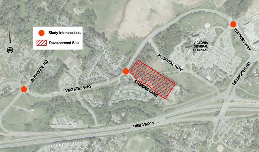
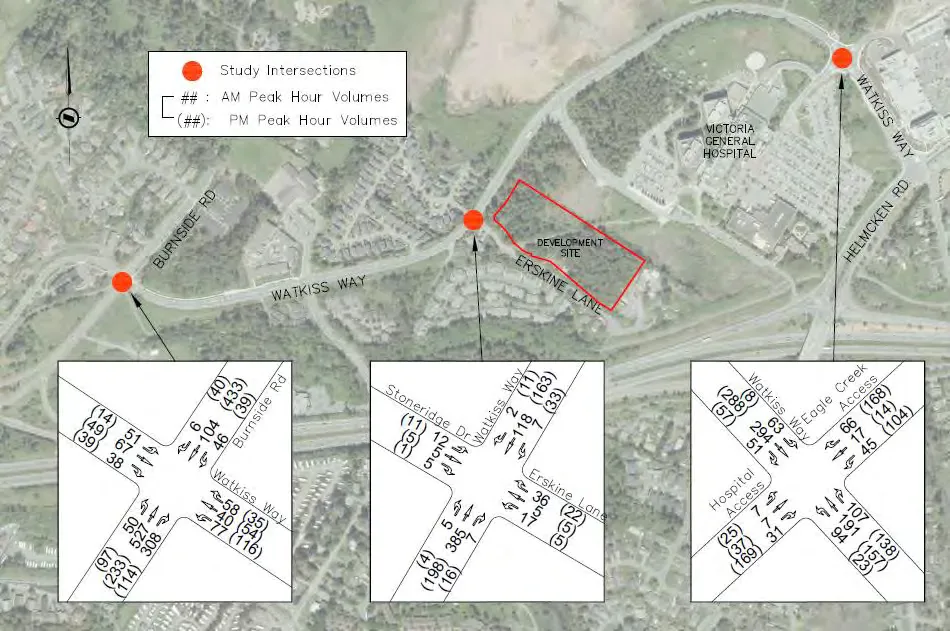
The following key intersections will be studied along with the proposed development accesses located on Erskine Lane:
- Watkiss Way / Erskine Lane / Stoneridge Drive (unsignalized, two-way stop controlled);
- Burnside Road W / Watkiss Way (signalized); and
- Watkiss Way / Hospital Access / Mall Access (unsignalized, roundabout).
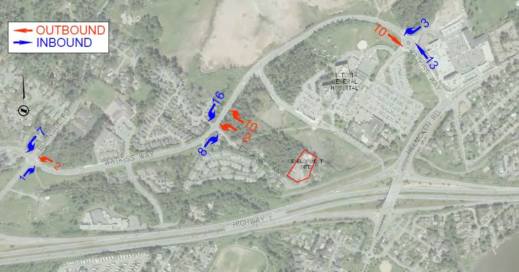
Figure 1 shows the study intersections and site location.
2.0 EXISTING CONDITIONS
2.1 LAND USE
The proposed site is currently zoned as A1 (Rural) and there is an existing single-family home on the site. The surrounding land use is a mix of multi-family and single family residential along Erskine Lane and Stoneridge Drive, with the Victoria General Hospital to the east. A proposed multi-family development is planned for the adjacent property at 7 Erskine Lane.
2.2 ROAD NETWORK
Watkiss Way is a two-lane major road with a posted speed limit of 50km/h. Burnside Road W is a two-lane collector road with a posted speed limit of 50km/h. Erskine Lane and Stoneridge Drive are two-lane local roads with a posted speed limit of 30km/h.
As Erskine Lane dead ends south of the proposed site, all site traffic will use the intersection of Watkiss Way / Erskine Lane. The four-legged intersection of Watkiss Way / Erskine Lane is stop controlled on Erskine Lane.
2.3 TRAFFIC COUNT
Traffic count data was taken from a previous study. Turning movement counts were conducted for the Watkiss Way intersections during the AM and PM peak hours (8:00AM – 9:00AM and 4:00PM to 5:00PM, respectively) on the following dates:
- Watkiss Way / Burnside Road: November 14, 2018
- Watkiss Way / Erskine Lane: November 16, 2017
- Watkiss Way / Victoria General Access: November 13, 2018
The existing counts were adjusted to 2019 traffic volumes using a 2% annual growth rate. This growth rate was also used to determine future background traffic volumes.
2.4 TRAFFIC MODEL
Weekday AM and PM peak hour traffic conditions will be modeled using Synchro 10 and SIDRA INTERSECTION 8 for the opening year full build-out and 10-year post opening year with and without the development traffic to identify short- and long-term impacts of the development. SIDRA will be used only to analyze traffic conditions at the roundabout (Watkiss Way / Hospital Access / Mall Access).
Measures of effectiveness (MOEs) will be evaluated for level of service (LOS), 95th percentile queues, total delay, and volume-to-capacity ratios (v/c). Background information on Synchro, SIDRA and LOS is provided in Appendix A. The criteria for mitigation are as follows:
- LOS E or better for individual turning movements; and
- 95th percentile queues extending beyond queuing capacity.
The horizon years will be evaluated for impacts to traffic operations with and without the development. The results will be used to determine if mitigation measures are needed as a result of background traffic growth or as a result of the development. Simulation settings for Synchro analysis will include:
- Vehicle length of 7.5m;
- Heavy vehicle length of 22.7m;
- Peak hour factors will use count data from study; and
- Heavy vehicle percentage will be based on count data.
2.5 EXISTING TRAFFIC CONDITIONS
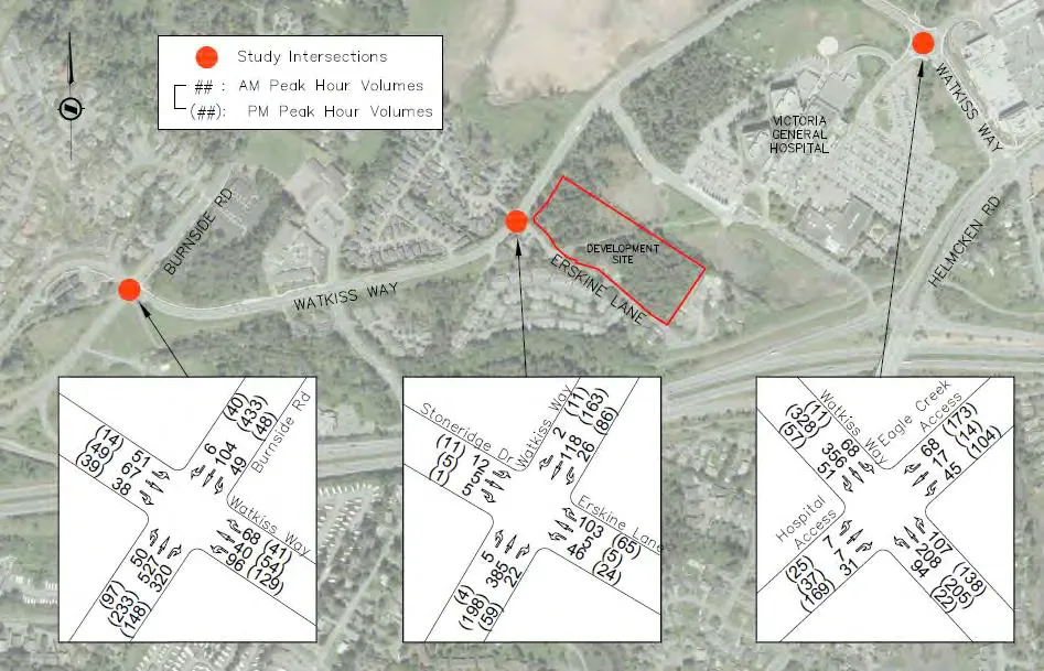
The existing 2019 AM and PM peak hour conditions are summarized in Table 1, and traffic volumes are shown in Figure 2. All intersections operate at LOS C or better in the AM and PM peak hours, and there are no existing queuing issues.
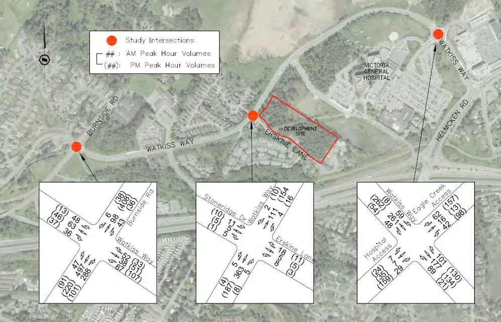
TABLE 1: 2019 AM AND PM PEAK HOUR TRAFFIC CONDITIONS
| Intersection | Movement | 2019 AM Peak Hour LOS | 2019 AM Peak Hour Delay (s) | 2019 AM Peak Hour 95th Queue (m) | 2019 PM Peak Hour LOS | 2019 PM Peak Hour Delay (s) | 2019 PM Peak Hour 95th Queue (m) |
|---|---|---|---|---|---|---|---|
| Burnside Rd W / Watkiss Way (Signalized) | EBLTR | C | 23 | 27 | B | 12 | 15 |
| WBLTR | C | 29 | 34 | C | 28 | 25 | |
| NBLT | B | 8 | 70 | A | 7 | 34 | |
| NBR | A | 0 | 0 | A | 0 | 5 | |
| SBLTR | A | 7 | 8 | A | 9 | 59 | |
| Watkiss Way / Erskine Ln | EBL | A | 8 | 0 | A | 8 | 0 |
| EBTR | A | 0 | 0 | A | 0 | 0 | |
| WBL | A | 8 | 0 | A | 8 | 0 | |
| WBTR | A | 0 | 0 | A | 0 | 0 | |
| NBLTR | B | 13 | 2 | B | 12 | 2 | |
| SBLTR | B | 14 | 2 | B | 13 | 2 | |
| Watkiss Way / Hospital - Mall Access | EBLTR | B | 11 | 20 | A | 9 | 16 |
| WBLT | A | 7 | 11 | A | 7 | 10 | |
| WBR | A | 0 | 0 | A | 2 | 10 | |
| NBLTR | A | 7 | 3 | B | 14 | 29 | |
| SBLTR | A | 7 | 7 | A | 10 | 16 |
3.0 BACKGROUND TRAFFIC CONDITIONS
Background traffic was assessed at a linear growth rate of 2.0% per year. Traffic volumes were projected to the assumed opening day in 2022, and the 10 year post opening date horizon in 2032.
3.1 DEVELOPMENT TRAFFIC FROM 7 ERSKINE LANE
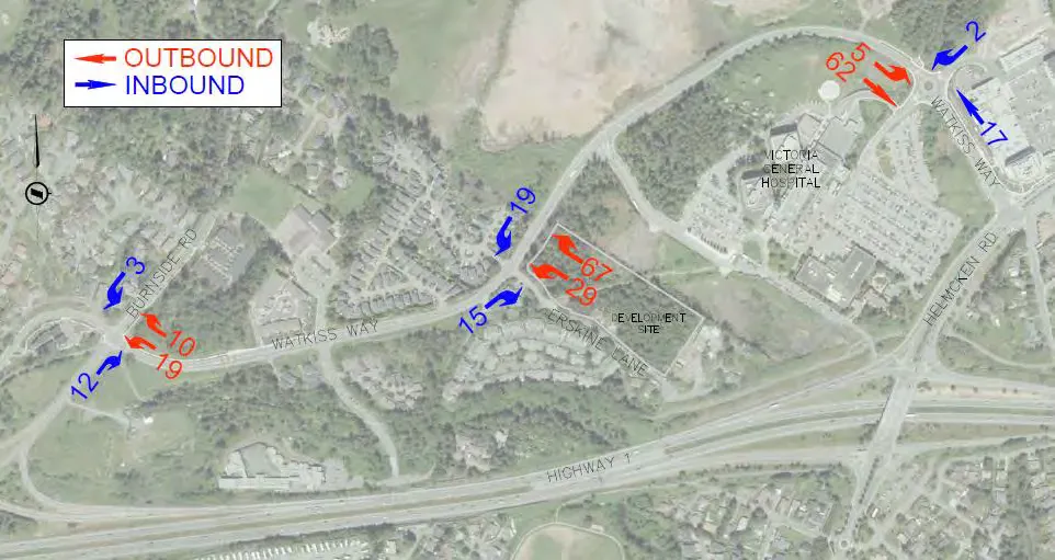
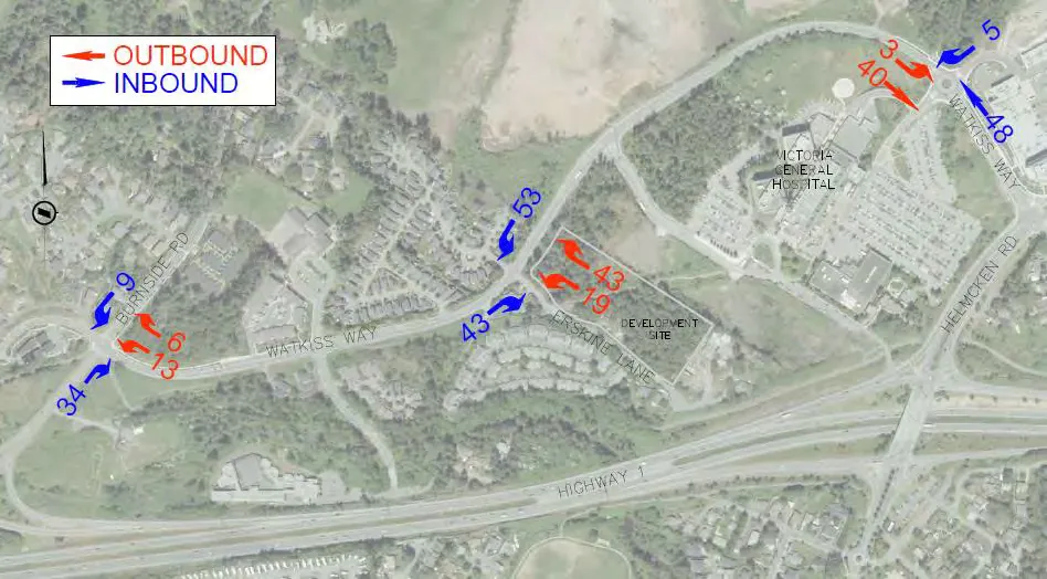
Development traffic from the adjacent 7 Erskine Lane site was added to background traffic. The proposed development is a 70-unit multi-family building which will generate 31 trips in the AM peak hour, and 36 trips in the PM peak hour. The trips from the development were assigned with consideration to the original TIA at the Watkiss Way / Erskine Lane intersection, and then distributed according to the trip assignment in this TIA, discussed further in Section 4.3. See Figure 3 and Figure 4 to see the distribution of these trips through the network in the AM and PM peak hour.
3.2 2022 BACKGROUND TRAFFIC CONDITIONS
The 2022 AM and PM peak hour conditions are summarized in Table 2, and traffic volumes are shown in Figure 5. All intersections operate at LOS C or better in the AM and PM peak hours, and there are no queuing issues.
TABLE 2: 2022 BACKGROUND TRAFFIC CONDITIONS
| Intersection | Movement | 2022 AM Peak Hour LOS | 2022 AM Peak Hour Delay (s) | 2022 AM Peak Hour 95th Queue (m) | 2022 PM Peak Hour LOS | 2022 PM Peak Hour Delay (s) | 2022 PM Peak Hour 95th Queue (m) |
|---|---|---|---|---|---|---|---|
| Burnside Rd W / Watkiss Way (Signalized) | EBLTR | C | 22 | 28 | B | 13 | 18 |
| WBLTR | C | 31 | 39 | C | 34 | 30 | |
| NBLT | B | 9 | 79 | A | 7 | 36 | |
| NBR | A | 0 | 9 | A | 0 | 5 | |
| SBLTR | A | 7 | 18 | B | 10 | 63 | |
| Watkiss Way / Erskine Ln | EBL | A | 8 | 0 | A | 8 | 0 |
| EBTR | A | 0 | 0 | A | 0 | 0 | |
| WBL | A | 8 | 1 | A | 8 | 1 | |
| WBTR | A | 0 | 0 | A | 0 | 0 | |
| NBLTR | B | 14 | 5 | B | 12 | 2 | |
| SBLTR | C | 15 | 3 | B | 14 | 2 | |
| Watkiss Way / Hospital - Mall Access | EBLTR | B | 12 | 29 | A | 10 | 19 |
| WBLT | A | 8 | 13 | A | 7 | 11 | |
| WBR | A | 0 | 0 | A | 2 | 11 | |
| NBLTR | A | 7 | 3 | B | 16 | 35 | |
| SBLTR | A | 8 | 8 | B | 11 | 22 |
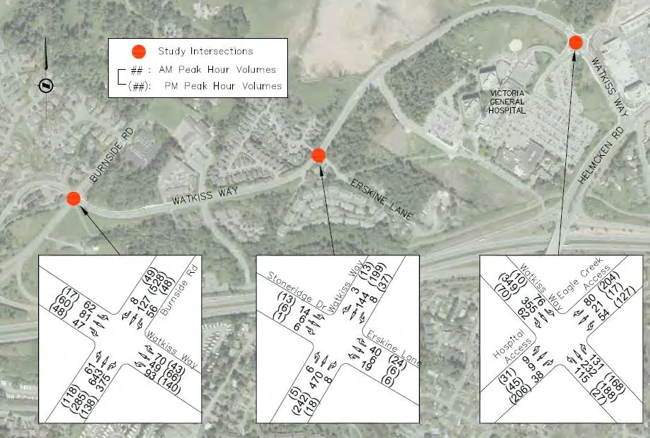
3.3 2032 BACKGROUND CONDITIONS
The 2032 AM and PM peak hour conditions are summarized in Table 3, and traffic volumes are shown in Figure 6. All intersection movements operate at LOS C or better in the AM and PM peak hours, except for the westbound movement at Burnside Road W / Watkiss Way which will operate at a LOS D based on existing signal timing and phasing. There no queuing issues in the long term.
TABLE 3: 2032 BACKGROUND TRAFFIC CONDITIONS
| Intersection | Movement | 2032 AM Peak Hour LOS | 2032 AM Peak Hour Delay (s) | 2032 AM Peak Hour 95th Queue (m) | 2032 PM Peak Hour LOS | 2032 PM Peak Hour Delay (s) | 2032 PM Peak Hour 95th Queue (m) |
|---|---|---|---|---|---|---|---|
| Burnside Rd W / Watkiss Way (Signalized) | EBLTR | C | 27 | 38 | B | 14 | 22 |
| WBLTR | D | 47 | 64 | D | 44 | 38 | |
| NBLT | B | 13 | 138 | B | 10 | 50 | |
| NBR | A | 0 | 9 | A | 0 | 5 | |
| SBLTR | A | 9 | 25 | B | 15 | 90 | |
| Watkiss Way / Erskine Ln | EBL | A | 8 | 0 | A | 8 | 0 |
| EBTR | A | 0 | 0 | A | 0 | 0 | |
| WBL | A | 9 | 1 | A | 8 | 1 | |
| WBTR | A | 0 | 0 | A | 0 | 0 | |
| NBLTR | C | 18 | 7 | B | 14 | 3 | |
| SBLTR | C | 19 | 5 | C | 16 | 2 | |
| Watkiss Way / Hospital - Mall Access | EBLTR | B | 17 | 71 | B | 13 | 42 |
| WBLT | A | 9 | 17 | A | 8 | 14 | |
| WBR | A | 0 | 0 | A | 2 | 14 | |
| NBLTR | A | 8 | 4 | C | 29 | 72 | |
| SBLTR | A | 9 | 11 | B | 15 | 44 |
4.0 POST DEVELOPMENT CONDITIONS
4.1 PROPOSED LAND USE
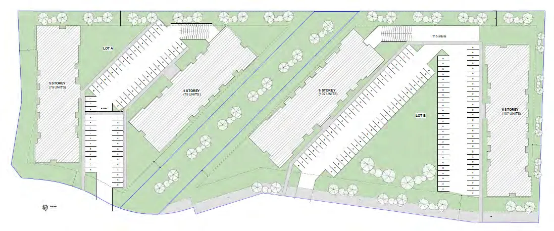
The development will consist of 362 dwelling units in four mid-rise buildings (6 storeys). Trip generation rates were estimated using the 10th Edition of the ITE Trip Generation Manual. Trip generation rates for the weekday AM and PM peak hours are shown in Table 4. Table 5 shows the estimated trips generated by the proposed development. They equate to 130 weekday AM peak hour trips and 158 weekday PM peak hour trips.
TABLE 4: PEAK HOUR TRIP GENERATION RATES
| ITE Land Use Code | Description | Weekday AM Rate | Weekday AM In | Weekday AM Out | Weekday PM Rate | Weekday PM In | Weekday PM Out |
|---|---|---|---|---|---|---|---|
| 221 | Multi-Family Housing (Mid-Rise) | 0.36 | 26% | 74% | 0.44 | 61% | 39% |
TABLE 5: PEAK HOUR DEVELOPMENT TRIPS
| Description | Units | Weekday AM In | Weekday AM Out | Weekday AM Total | Weekday PM In | Weekday PM Out | Weekday PM Total |
|---|---|---|---|---|---|---|---|
| Multi-Family Housing (Mid-Rise) | 362 | 34 | 96 | 130 | 96 | 62 | 158* |
*Development trips were initially calculated for 360 units. The addition of 2 units results in one (1) additional trip, however, the analysis was not recalculated as the additional trip would not significantly impact the results of this analysis.
4.2 SITE ACCESS
The site is accessed from Erskine Lane via Watkiss Way. Pedestrians and cyclists have the option to use the connection to Galloping Goose Trail at the south end of Erskine Lane to walk/bike to the site. There is a trail passing through the site that connects Erskine Lane to the Victoria General Hospital.
There are two accesses proposed on Erskine Road. One site access is proposed for the two buildings north of the trail to the hospital, and the second site access is proposed for the two buildings south of the trail. See Figure 7 for the site plan.
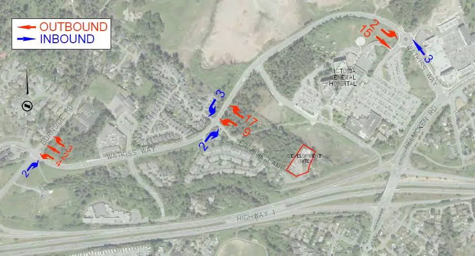
4.3 TRIP ASSIGNMENT
The site trips were assigned based on the existing traffic distributions and consideration of nearby origin / destinations. The following summarizes directional split percentages of the site trips.
Trips In
- 50% of trips from Helmcken Road;
- 35% of trips from Burnside Road (South);
- 10% of trips from Burnside Road (North);
- 5% of trips from Eagle Creek Village;
Trips Out
- 65% of trips to Helmcken Road;
- 20% of trips to Burnside Road (South);
- 10% of trips to Burnside Road (North)
- 5% of trips to Eagle Creek Village;
Figure 8 and Figure 9 show the trip assignments for AM and PM peak hours.
4.4 2022 OPENING DAY TRAFFIC CONDITIONS
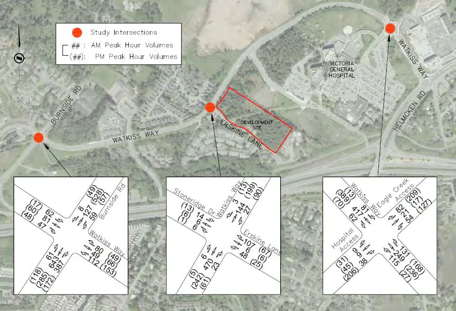
The 2022 AM and PM peak hour conditions are summarized in Table 6, and traffic volumes are shown in Figure 10. All intersections operate at LOS D or better in the AM and PM peak hours, and there are no queuing issues. The westbound movement at Burnside Road W / Watkiss Way worsens to LOS D from LOS C with the addition of development traffic, however, only two additional seconds of delay are added indicating that the movement was already borderline LOS D.
TABLE 6: 2022 POST DEVELOPMENT TRAFFIC CONDITIONS
| Intersection | Movement | 2022 AM Peak Hour LOS | 2022 AM Peak Hour Delay (s) | 2022 AM Peak Hour 95th Queue (m) | 2022 PM Peak Hour LOS | 2022 PM Peak Hour Delay (s) | 2022 PM Peak Hour 95th Queue (m) |
|---|---|---|---|---|---|---|---|
| Burnside Rd W / Watkiss Way (Signalized) | EBLTR | B | 18 | 25 | B | 13 | 18 |
| WBLTR | C | 31 | 44 | D | 36 | 33 | |
| NBLT | B | 10 | 80 | A | 7 | 36 | |
| NBR | A | 0 | 9 | A | 0 | 5 | |
| SBLTR | A | 8 | 18 | B | 11 | 67 | |
| Watkiss Way / Erskine Ln | EBL | A | 8 | 0 | A | 8 | 0 |
| EBTR | A | 0 | 0 | A | 0 | 0 | |
| WBL | A | 9 | 2 | A | 8 | 2 | |
| WBTR | A | 0 | 0 | A | 0 | 0 | |
| NBLTR | C | 22 | 20 | C | 18 | 11 | |
| SBLTR | C | 21 | 5 | C | 20 | 3 | |
| Watkiss Way / Hospital - Mall Access | EBLTR | B | 14 | 51 | B | 11 | 24 |
| WBLT | A | 8 | 14 | A | 8 | 13 | |
| WBR | A | 0 | 0 | A | 1 | 13 | |
| NBLTR | A | 8 | 3 | B | 17 | 38 | |
| SBLTR | A | 8 | 8 | B | 12 | 27 |
4.5 2032 POST DEVELOPMENT CONDITIONS
The 2032 AM and PM peak hour conditions are summarized in Table 7, and traffic volumes are shown in Figure 11. All intersections operate at LOS D or better in the AM and PM peak hours, and there are no queuing issues. The addition of site traffic adds on a few seconds of delay to some movements (<6s), however, the level of service for most movements are unchanged compared to background conditions.
TABLE 7: 2032 POST DEVELOPMENT TRAFFIC CONDITIONS
| Intersection | Movement | 2032 AM Peak Hour LOS | 2032 AM Peak Hour Delay (s) | 2032 AM Peak Hour 95th Queue (m) | 2032 PM Peak Hour LOS | 2032 PM Peak Hour Delay (s) | 2032 PM Peak Hour 95th Queue (m) |
|---|---|---|---|---|---|---|---|
| Burnside Rd W / Watkiss Way (Signalized) | EBLTR | C | 23 | 36 | B | 14 | 22 |
| WBLTR | D | 50 | 74 | D | 49 | 42 | |
| NBLT | C | 16 | 145 | B | 10 | 50 | |
| NBR | A | 0 | 10 | A | 0 | 6 | |
| SBLTR | B | 12 | 30 | B | 17 | 96 | |
| Watkiss Way / Erskine Ln | EBL | A | 8 | 0 | A | 8 | 0 |
| EBTR | A | 0 | 0 | A | 0 | 0 | |
| WBL | A | 9 | 2 | A | 9 | 3 | |
| WBTR | A | 0 | 0 | A | 0 | 0 | |
| NBLTR | D | 34 | 33 | C | 23 | 16 | |
| SBLTR | D | 29 | 8 | C | 24 | 4 | |
| Watkiss Way / Hospital - Mall Access | EBLTR | C | 21 | 110 | B | 15 | 58 |
| WBLT | A | 9 | 18 | A | 9 | 17 | |
| WBR | A | 0 | 0 | A | 1 | 17 | |
| NBLTR | A | 9 | 4 | C | 34 | 81 | |
| SBLTR | A | 9 | 12 | B | 17 | 51 |
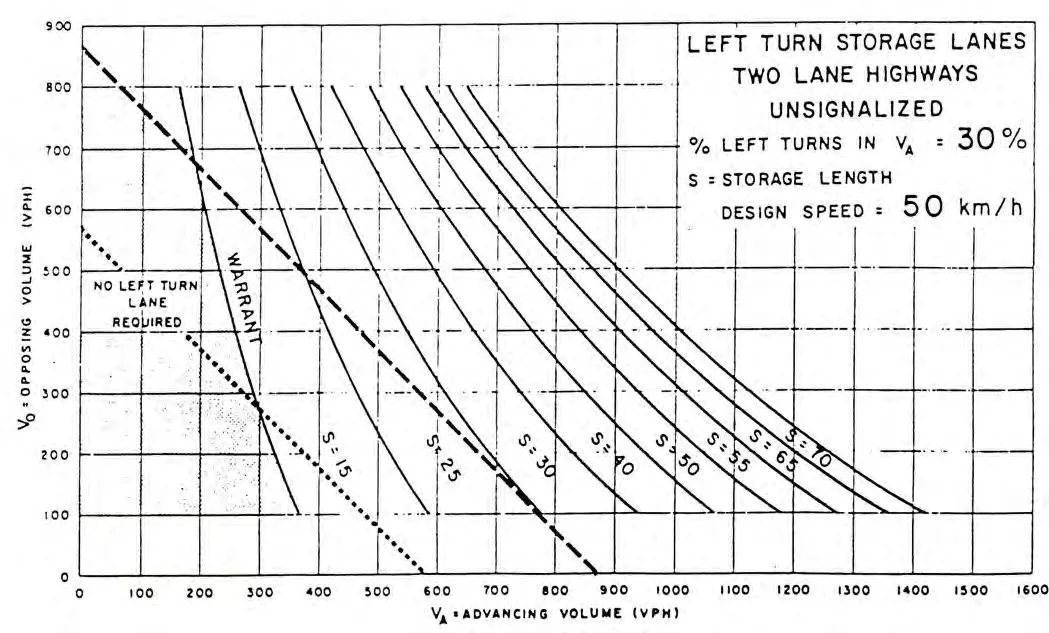
A left-turn lane warrant was conducted in the PM peak hour at Erskine Lane / Watkiss Way for the westbound-left turn movement at the intersection. Although there is no reported operational issue, the number of vehicles turning left is significant (90 vehicles) and is approximately 30% of westbound traffic on Watkiss Way in the PM peak hour. The left-turn warrant indicated that a 15m storage lane is required, though the warrant is barely met as shown in Figure 12. Long-term conditions should be monitored to determine if volume targets are still being met.
5.0 ACCESS REVIEW
5.1 ACCESS SPACING
The proposed first site access is located on Erskine Lane 55m south of Watkiss Way. The provided 55m spacing exceeds the TAC’s minimum corner clearance of 15m for local roads from a stop-controlled major intersection. Therefore the location of the driveway access is appropriate. The spacing between the driveways exceeds 5m and therefore is also appropriate.
5.2 SIGHT DISTANCES
The sight distance at all the proposed accesses (on Erskine Lane) were reviewed to ensure sufficient sight distance is available for motorists turning into and out of the site. A 30 km/h speed limit sign is posted on Erskine Lane.
Sight distances are met for the access located south of the hospital trail. At the first access the measured sight distance to the right (north) is 50m which does not meet the required intersection sight distance (65m) for left turns from stop for 30 km/h. However, there is no reason for vehicles to turn left out of the site as a left turn would take drivers to a dead-end. If a rare vehicle turns left the approaching vehicle on Erskine Lane has sufficient sight distance to stop or slow for a turning vehicle. Table 8 provides a summary of sight distances at Access 1 for 30 km/h.
TABLE 8 : SIGHT DISTANCES AT ACCESS 1
| Movement | Measured Sight Distance | Required Intersection Sight Distance | Sight Distance Met? |
|---|---|---|---|
| Left Turn from Stop | 100m (looking left) | 65m (looking left) | Yes |
| 50m (looking right) | 65m (looking right) | No | |
| Right Turn from Stop | 100m (looking left) | 55m (looking left) | Yes |
| Through Traffic (on Erskine Lane) | 50m+ (southbound) | 35m (SSD for 30 km/h) | Yes |
| 50m+ (northbound) | 50m (SSD for 40 km/h) | Yes |
6.0 ACTIVE TRANSPORTATION
6.1 PEDESTRIANS AND CYCLISTS
There are currently no sidewalks along Erskine Lane and Stoneridge Drive. On Watkiss Way there are sidewalks along the north side (Stoneridge) near the intersection. The development will add pedestrians around the area due to significant multi-family residential units. A sidewalk along the development frontage would aid in linking the site to Watkiss Way, the hospital trail, and the Galloping Goose Trail.
There are bike lanes on both sides on Watkiss Way. Cyclists and pedestrians can utilize the Galloping Goose Trail adjacent to the site by using the trail connection.
6.2 TRANSIT
There are three routes (# 14, 22 and 39) within the walking distance from the development site. For the transit route #14 and #22, the closest bus stop is on Hospital Way (Victoria General Hospital) north of the development site and provides services to the downtown several times per hour on weekdays. Transit users from the site can utilize the trail (on-site) between Erskine Lane and VGH to access the bus stops. For the transit route #39, the closest bus stop is on Watkiss Way east of Erskine Lane and provides services to University of Victoria via Camosun College (Interurban Campus) one or two times per hour.
7.0 CONCLUSIONS
The development will not significantly impact the traffic operations at the three study intersections. All movements will operate at LOS D or better in the long-term in both the background and post development conditions. A 15m left turn lane on Watkiss Way at Erskine Lane may be warranted in the long term, but conditions should be confirmed prior to implementing.
The proposed first site access location does not meet the TAC’s intersection sight distance for left turns from stop for a design speed of 30 km/h. However, at the access the measured sight distance (100m: looking to left) exceeds the required sight distance (55m) for right turns from stop. The exiting site vehicles will take right turns to head Watkiss Way as the road dead ends to the south. The sight distance to the left (south) is sufficient. Also the measured sight distance (50m) to right exceeds the minimum stopping sight distance (35m) for 30 km/h and it also meets the stopping sight distance (50m) for 40 km/h. Therefore, the proposed access location is acceptable from a sight distance safety perspective.
A sidewalk should be provided along the Erskine Lane development frontage to provide a better connect to the hospital trail, and Galloping Goose Trail.
8.0 RECOMMENDATION
- The developer will provide a sidewalk along the Erskine Lane development frontage.
- The Town to monitor traffic volumes at Erskine Lane / Watkiss Way, and consider implementing a 15m left-turn lane on Watkiss Way in the long term (10 years) if volumes grow as projected in the long term.
Document Images
(2)