Planning & Development Report - DEVELOPMENT PERMIT 2019/12 – 1801 Admirals Road
Report on an environmental development permit application for an assembly hall and parking lot modifications at Craigflower Manor.
- TO: Committee of the Whole
- FROM: J. Chow, Senior Planner
- DATE: January 8, 2020
- MEETING DATE: January 14, 2020
- FILE NO.: 3060-20-2019/12
DEVELOPMENT PERMIT 2019/12 – 1801 Admirals Road
RECOMMENDATION
THAT the January 8, 2020 report from the Senior Planner titled “Development Permit 2019/12 – 1801 Admirals Road” be received for information.
CHIEF ADMINISTRATIVE OFFICER’S COMMENTS
I concur with the recommendation.
DIRECTOR OF DEVELOPMENT SERVICES’ COMMENTS
I concur with the recommendation.
DIRECTOR OF ENGINEERING’S COMMENTS
I concur with the recommendation.
DIRECTOR OF PROTECTIVE SERVICES’ COMMENTS
I concur with the recommendation.
PURPOSE OF REPORT
To introduce an environmental development permit to facilitate the development of an assembly hall at Craigflower Manor that is outside of the DP area. The development permit addresses the following issues:
- Modification of an existing parking lot that is partly within the Natural Watercourse and Shoreline Environmental Development Permit Area.
- Storm water management and native plant restoration
- Removal of a shed
- Variances to reduce the amount of required parking and to permit a steeper gradient and cross slope for parking areas
BACKGROUND
The 9740m² parcel is the site of Craigflower Manor and is owned by the Province of British Columbia. It is leased to the Victoria Highland Games Association, a society that promotes Scottish culture, art and sport. The parcel was rezoned from P-3: Parks and Recreation to P-9: Parks and Recreation Cultural Facility in March 2019 to allow a broader range of uses that would facilitate the development and operation of a cultural heritage centre.
The parcel has more than 90m of waterfront where Portage Inlet meets the Gorge Waterway. Land within 15m of the natural boundary is in the Natural Watercourse and Shoreline Development Permit Area. A sewer right-of-way runs through the site from the Admirals Road / Island Highway intersection to the water.
The manor was constructed by the Hudson’s Bay Company in 1856. It was designated a National Historic Site in 1964 and a Provincial Heritage Site in 1967. A Heritage Alteration Permit is not required for the development of land owned by the Province.
PROJECT INFORMATION
The proposal is to construct an 897.8m² assembly hall as shown in Attachments 2-5. The purpose of the hall is to hold events and support the ongoing maintenance of the 282m² manor building. The proposed building is not subject to form and character development permit requirements, but approval of an environmental development permit is requested for the following:
1. Modifications to land within the Natural Watercourse and Shoreline Environmental Development Permit Area.
The proposed modifications to land within the DPA are to rebuild and upgrade the existing parking lot, add stormwater management features, and enhance native vegetation.
a. Parking Lot The portion of the parking lot within the development permit area would be raised between 15 and 25 cm and the curb would be moved approximately 1m inland, away from the shoreline as shown in Figures 1 and 2. The area of the parking lot within the DPA would be reduced from 205m² to 180m².
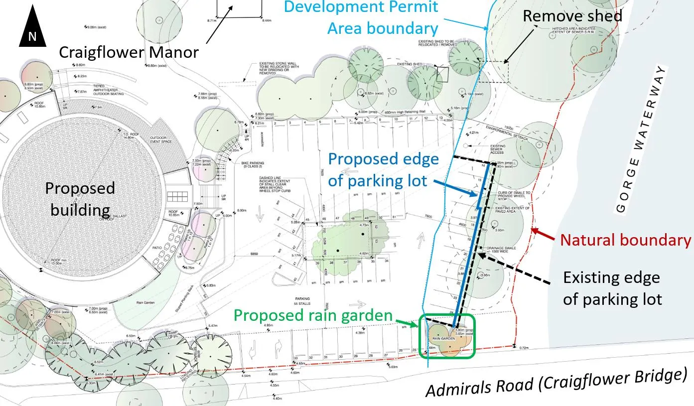
Figure 1. Site plan excerpt (based on Attachment 2 Plan A1.1)
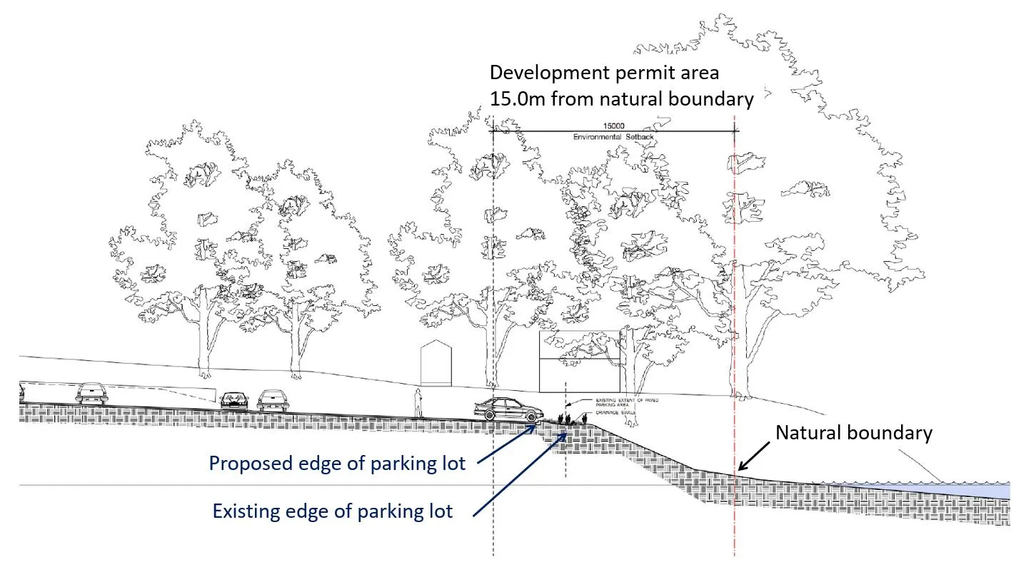
Figure 2. Partial site section (based on Attachment 2 Plan A4.1)
b. Stormwater Management
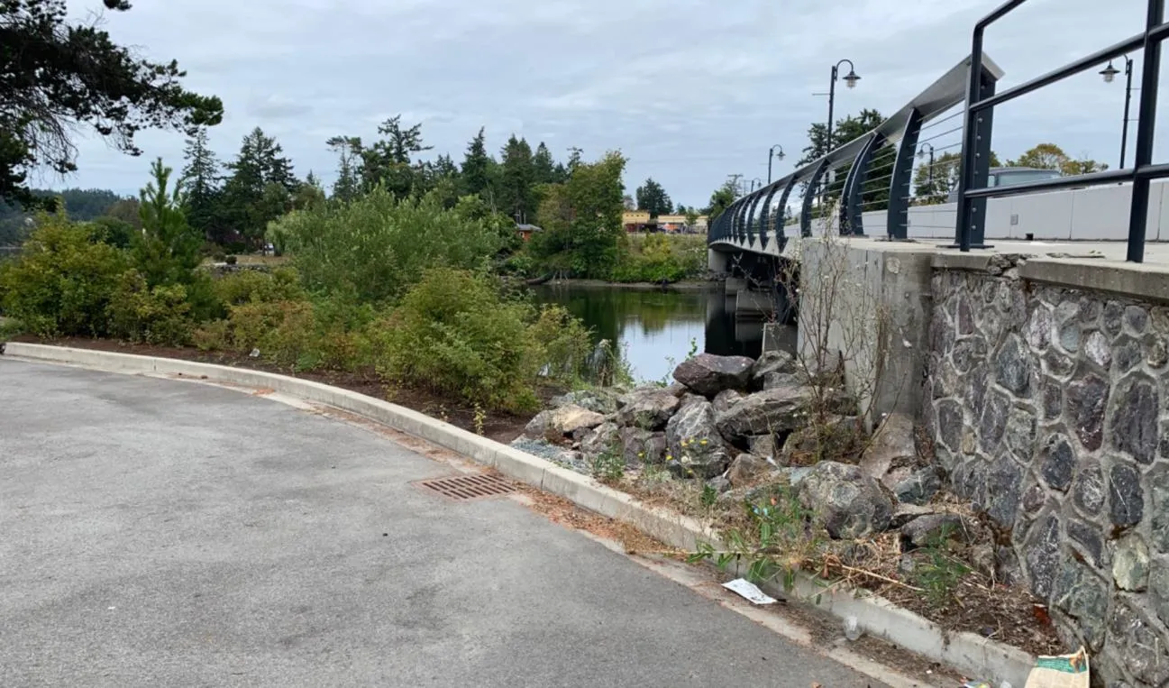
Figure 3. Rockpile in area proposed for rain garden
Storm water runoff from the parking lot is currently directed into a catch basin and discharged into the Gorge Waterway. Catch basins can trap sediment but otherwise do not treat storm water. The proposal is to install several rain gardens onsite for the new hall and the parking lot expansion. The rain gardens would detain storm water (which would also allow some seepage into the ground to maintain the local hydrology) and filter out potential contaminants. The Preliminary Storm Water Concept also proposes oil/grit separators for storm water entering the rain gardens with the goals of simplicity and reducing long term maintenance costs.
The proposal is for one of the rain gardens to be installed in the corner of the property beside Craigflower Bridge as shown in Figures 1 and 3. This rain garden would be within the development permit area 9.0m from the natural boundary and connect to the existing outfall under the bridge.
c. Native plant restoration and enhancement The biologists’ report (Attachment 6) recommends an Environmental Protection Plan for construction on the site including erosion and sediment control, spill prevention and response, minimizing habitat disturbance, and environmental monitoring.
d. Removal of a shed An existing shed in the DPA north of the parking lot would be removed (see Figure 1).
2. Variances for the following:
- Variances are requested to reduce the required number of parking spaces from 61 to 55 and to increase the gradient and cross slope of parking area from 2% to 5%.
At one time there was a gas station near the proposed building site. The Provincial Contaminated Sites Branch has accepted a proposal for independent site remediation and issued a site profile release on January 7, 2020 that permits the Town to consider this development permit application for approval.
DISCUSSION
The key issues are:
- How does the proposal address the development permit area guidelines?
- How does the proposal comply with zoning requirements?
- What are the next steps for Council consideration of the development permit?
1. Development Permit Area Guidelines
Ideally, land within the development permit area would be naturally vegetated and free of development, for example by rebuilding the parking lot completely outside of the development permit area; however, one of the objectives of the development permit area is to “balance development opportunities with ecological conservation” and that is acknowledged in the guidelines. In this case, rebuilding part of the existing parking lot within the development permit area is justified given the following considerations:
a. The Statement of Significance in the Canadian Register of Historic Places includes “the unobstructed view of the house from Admirals and Craigflower Roads, Craigflower Bridge and the waterway” as one of the key character defining elements of Craigflower Manor. This was a major consideration in the design and alignment of the new Craigflower Bridge. The Province’s 2013 Craigflower Manor and Schoolhouse Management Plan also notes: “The parking lot area is not part of the historic landscape of the Manor site but provides an important role in supporting access to the site. Trees along its east edge screen it from view from Admirals Road and Craigflower Bridge, reducing its visual impact. Its surface is at a lower elevation than the Manor yard so that it also has limited visual impact on the cultural landscape around the Manor itself...”
b. Admirals Road access is the main access to the site so the parking lot must be in this location. It is not desirable to have an access for parking off of Island Highway as this would be a detrimental impact to the heritage values of the site.
c. Shifting the eleven parking spaces completely out of the development permit area and moving the building closer to the corner to continue to accommodate parking adjacent to the Admirals frontage was examined as an option. However, this would create setback issues for the proposed hall from Island Highway and would impact the stand of trees at the Island Highway / Admirals Road intersection that is a significant gateway feature of the Town.
d. The portion of the parking lot within the DPA would be reduced from 205m² to 180m² (approximately 19% of land within the DPA). In addition, by using already disturbed areas of the site, impact on heritage values of the site is mitigated, and no additional environmentally sensitive areas are disturbed.
Siting the proposed rain garden within the development permit area as shown in Figure 1 can be supported for the following reasons: a. The location is in an area that was extensively disturbed by bridge construction and is currently covered with rubble (Figure 3) b. The rain garden is at the low point of the property to collect storm water for treatment. Improving storm water quality is a significant aspect of the coordinated rehabilitation of the Gorge Waterway to help support spawning populations of herring, coho and chum salmon, and cutthroat trout. c. In accordance with the guidelines, the proposed vegetation will feature native plants, specifically native grasses, bracken fern, and three Vine maples.
The decision to approve or decline a development permit application must be made with regard to how it addresses the development permit area guidelines. The relevant guidelines of the Natural Watercourse and Shoreline Development Permit Area are highlighted in Attachment 7.
The proposal complies with intent of the guidelines as follows: a. The amount of paving within the development permit area would be reduced. b. Storm water runoff is currently untreated and is not detained on site. The installation of raingardens would detain/cleanse rainwater, allow infiltration, and improve storm water quality. c. The arborist’s report (Attachment 8) identifies trees outside and within the development permit area. Management of trees outside of the development permit area will be administered through the Tree Protection Bylaw No. 695, 2009 in association with the building process. Three trees in the DPA can be retained as the parking lot modifications do not require excavation into the existing grade. The proposal is to raise the grade of the parking lot across part of the protected root zones so the recommendations and mitigation measures from the arborists report would be integrated into the development permit. d. The biologist’s report (Attachment 6) contains recommendations for an Environmental Protection Plan for construction on the site including erosion and sediment control, spill prevention and response, minimizing habitat disturbance, and environmental monitoring. The recommendations of that report should be incorporated into the development permit conditions.
The proposal can be supported because it carefully balances environment objectives of the development permit area guidelines, the historic and cultural significance of the manor property and the need for adequate parking. The following items relating to the guidelines should be addressed prior to Council consideration of the development permit: i. The arborists report recommends permeable paving in the critical root zones of retained trees and the plans should reflect that. ii. Further information should be provided on native plan restoration. While native plants are proposed for the rain garden and the society has been removing invasive species, the DPA guidelines target ecologically appropriate vegetation for an average 15m wide (minimum 5 m) shoreline zone over 50% of the shore length in heavily impacted areas. iii. An engineering overview to provide preliminary assurance that the proposed development will be on stable ground, will not cause erosion and will be flood resistant.
2. Zoning Requirements
| P-9: Parks and Recreation Cultural Facility Zone | Required | Proposed |
|---|---|---|
| Floor Space Ratio ᵃ, maximum. Proposed = (897.8+282)/9740 | 0.4:1 | 0.13:1 |
| Lot Coverage ᵃ, maximum | 20% | 11% |
| Impermeable Surface Coverage ᵃ, maximum | 60% | 30% |
| Building Height, maximum | 9.0m | 7.6 |
| Front Lot Line setback, minimum | 7.5m | 10.5m |
| Rear Lot Line setback, minimum (see natural boundary) | 7.5m | 58.5m |
| Side Lot Line setback, minimum | 6.0m | |
| Flanking Lot Line setback, minimum (Admirals Road) | 6.0m | 6.0m |
| Other Zoning requirements | Required | Proposed |
| Setback to the natural boundary of the sea | 15.0m | 58.5m |
| Off-street Parking-Spaces ᵃ (see Attachment 3 for breakdown) | 61 | 55* |
| Small Car spaces (30% of spaces) | 18 | 2 |
| Maximum gradient and cross slope of parking areas | 2% | 5%* |
| Bicycle Parking | 9 | 9 |
| Bicycle Parking – Class 1 (secure, weather protected) – 20% | 2 | tbc |
| Bicycle Parking – Class 2 (short term) – 80% | 7 | 9 |
Notes: ᵃ = both buildings; * = Variance requested
Variances to bylaw requirements are a tool to address to unique circumstances. This application requests variances for the number of parking spaces and for the gradient and cross slope of parking areas as follows:
A. Number of Parking Spaces
The number of off-street parking spaces is requested to be varied from 61 to 55. The breakdown of parking requirements is as follows:
| Use | Floor area | Parking ratio | Required spaces | Proposed spaces |
|---|---|---|---|---|
| Assembly Hall | 518.5m² | 1 per 10m² | 52 | |
| Office (in hall) | 23.5m² | 1 per 30m² | 1 | |
| Craigflower Manor | 282.0m² | 1 per 40m² | 8 | |
| Total | 61 | 55 |
While there are no opportunities for on-street parking in the immediate area, the applicant suggests it is unlikely that the hall and Craigflower Manor would be both fully occupied at the same time. The eight required spaces for Craigflower Manor could arguably counterbalance the requested variance of six spaces for the hall. It should be noted that.
The variance can be justified in this case because keeping the parking lot expansion to a minimum would help maintain the heritage character of Craigflower Manor (see the development permit area guidelines discussion in this report). A row of three mature trees at the north end of the parking lot could then be retained and enhanced with additional trees on the slope up to preserve the historic grounds of the manor.
B. Parking gradient and cross slope
A variance is requested to increase the maximum gradient and cross slope of the parking spaces from the standard of 2% for non-residential uses to 5%. The variance is requested because the property slopes down from Island Highway to the natural boundary. Ordinarily a level parking area is desirable, but to meet the requirement there would have to be cutting and filling on the site that would also mean higher retaining walls. We note that the residential standards for parking allow for up to a 6% gradient and cross slope. While this is a non residential purpose, the compromise of a higher than allowed gradient and cross slope is reasonable given the context and the impact of additional excavation and retaining walls.
3. Next Steps
In addition to addressing any comments from Committee of the Whole, the application can be considered by Council once the following issues are settled:
- Confirmation of parking lot paving materials and permeability, especially within the critical root zones of retained trees.
- Further information on native plant restoration and enhancement.
- An engineering overview to provide preliminary assurance that the proposed development will be on stable ground, will not cause erosion and will be flood resistant.
RECOMMENDATION
THAT the January 8, 2020 report from the Senior Planner titled “Development Permit 2019/12 – 1801 Admirals Road” be received for information.
SUBMITTED BY: Jeff Chow, MCIP RPP, Senior Planner
REVIEWED BY: Lindsay Chase, MCIP RPP, Director of Development Services
Y:\Land Administration\3060 Development Permits\20 Permits\2019-12 Admirals Rd 1801\Reports\2020 01 14 1801 Admirals Road DP2019-12.doc
Document Images
(5)