Protecting Public Green Space: THE NEED TO PROTECT PUBLIC WATERFRONT ON THE GORGE FROM PRIVATE USE AND OCCUPATION
A research paper and submission by the UVic Environmental Law Centre identifying 11 examples of possible private encroachment on public lands.
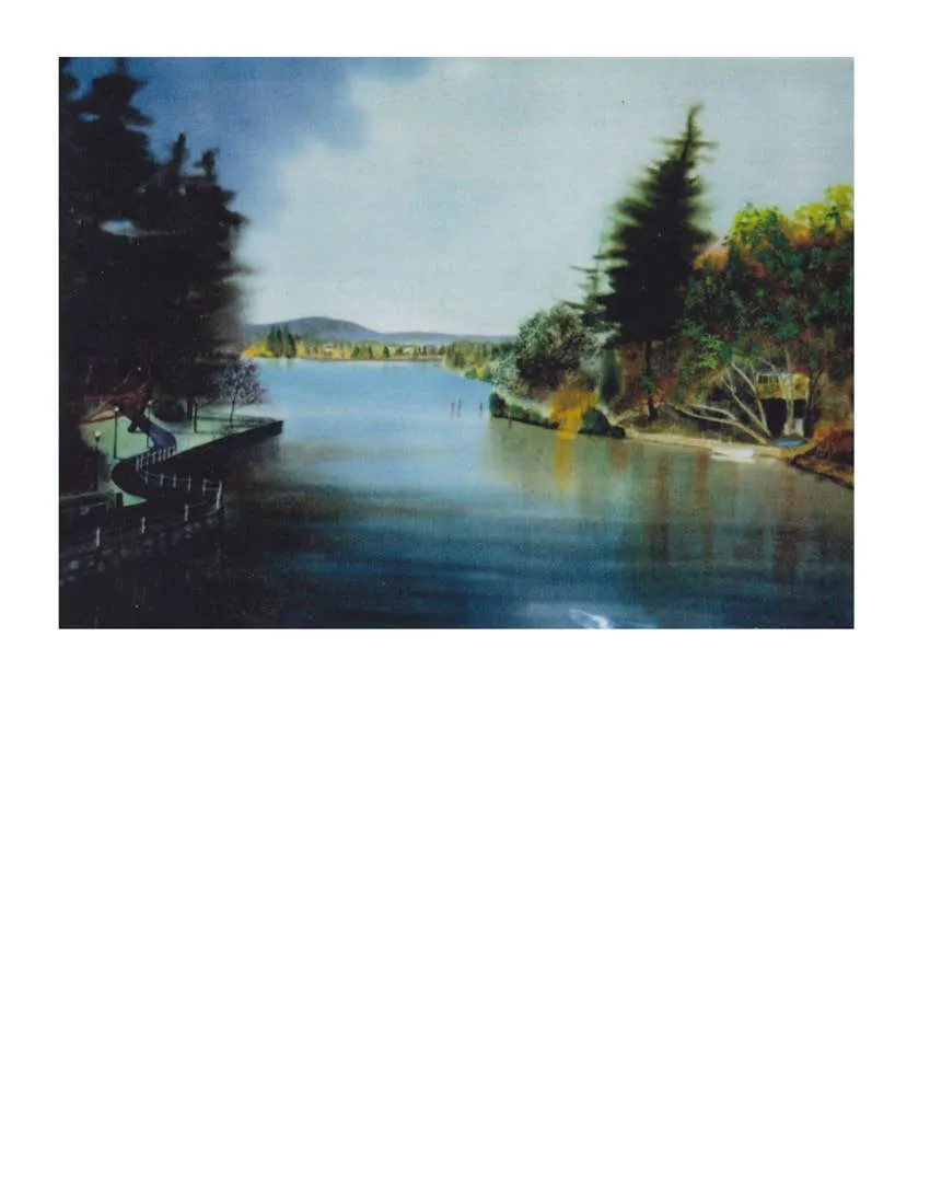
THE NEED TO PROTECT PUBLIC WATERFRONT ON THE GORGE FROM PRIVATE USE AND OCCUPATION
A Draft Submission to Your Worships:
(Submitted subject to Municipal Verification of the contents) Mayor Richard Atwell, District of Saanich Mayor Barb Desjardins, Township of Esquimalt
Protecting Public Green Space
University of Victoria, Environmental Law Centre Prepared for the Veins of Life Watershed Society Neal Parker, Law Student Calvin Sandborn, Legal Director June 2017
Contents
I. Loss of Public Access to the Gorge – The Need to Investigate What We’re Losing ............... 2 II. Background: The Importance of Protecting Public Waterfront on the Gorge ...................... 4 Why is Public Green Space Important? ...................................................................................... 4 Impacts of Losing Natural Areas................................................................................................. 5 Ecological Integrity.................................................................................................................. 5 Social and Health Benefits of Greenways Networks and Public Green Space ....................... 6 Livability and Prosperity.......................................................................................................... 6 III. The Research – Examples We Looked At................................................................................ 9 IV. Remedies............................................................................................................................... 65 V. Conclusion and Recommendations ...................................................................................... 66
Note:
The submission below raises a concern that local governments are failing to protect Gorge Waterfront public lands from private use and occupation. In this report we ask the governments of Esquimalt and Saanich to investigate -- in order to determine the extent to which public assets may, or may not, have been lost or compromised. Our preliminary investigation indicates that there is likely a widespread loss of public values.
However, we emphasize that our investigation of the eleven sites described are preliminary and subject to possible correction. That is why we are submitting this report to the Mayors with a specific request that their municipal staff carefully examine our findings – and either verify or correct them. After municipal staff check these findings, we request that verified results be brought to Council for a discussion of our report’s recommendations and of the important public interest issues raised.
Finally, note that we ascribe no fault to any private landowners or neighbours -- many of whom may be unaware of where municipal land boundaries are. The fault, if any, lies with local governments that fail to zealously protect the property rights of the general public.
I. Loss of Public Access to the Gorge – The Need to Investigate What We’re Losing
The research in this document indicates that the governments of the District of Saanich and the Township of Esquimalt may be failing their duty to ensure that publicly owned Gorge waterfront lands actually remain public. This has been a longstanding complaint. Veins of Life Watershed Society and others have long argued that adjacent or nearby neighbours often encroach onto public lands and convert them to private use. As early as 1999 the Victoria Natural History Society did a survey report that identified the problem of private encroachment onto public spaces in Saanich.² There have long been requests that governments stop such privatization of public lands.
In this report we have attempted to investigate such complaints. Focusing on end-of-road access points around the Gorge Waterway in Esquimalt and Saanich, we have attempted to document instances where such encroachment and loss of public value appears to have occurred.
Below you will find 11 examples that raise concerns. Our preliminary research raises the question of whether public green space has been effectively privatized – or compromised -- by nearby landowners/residents. It appears likely that public lands are being compromised or used for private purposes in many of these cases – but we hereby request that you investigate to see if we are correct.
We ask you to consider and carefully examine whether these 11 sites are -- or are not -- problematic. If you can confirm encroachment or compromise of public use in any of these instances, we ask that you consider possible remedies to re-assert public control over public lands.³ For example, if local governments posted clear signs and appropriate marking and fencing, this could prevent neighbours from innocently encroaching on public lands.
More important, we suspect that this handful of examples is just the tip of the iceberg. We understand that the problem of encroachment is quite common around the Gorge, Victoria Harbour and elsewhere -- because governments are less vigilant than private landowners in asserting ownership. Unfortunately, this lack of vigilance means that the public loses enjoyment of precious waterfront, and loses the opportunity to create future Waterfront Greenways in the community.
Therefore, if municipal officials confirm the problems identified in this report, we call on you to address the critical overriding issue of protecting public access to all public waterfront. If your staff confirm the preliminary research below, we will call on your governments – and all other relevant local governments -- to conduct a comprehensive survey of all public lands along the Gorge and Victoria Harbour, to ensure that all public lands remain just that: public.
We will also call on all the local governments to develop long-term policies to protect public waterfront for public use – and to develop a comprehensive Gorge/Harbour Greenways system.
² Victoria Natural History Society Greenways Inventory Saanich Rights of Way that Have Greenway Potential (March 1999), Saanich, District of Saanich Archives (SROW Project Master)
³ Governments would have a number of possible remedies for encroachment, for cutting vegetation, for depositing objects, or for constructing things on public land. For example, a municipality could deal with encroachment by suing the encroacher in trespass. Alternatively, municipal bylaws such as Saanich’s Streets and Traffic Bylaw and Parks Management and Control Bylaw could be invoked – they prohibit such things as unauthorized construction of structures and depositing of materials on the land. In addition, the Province and local governments would have possible remedies against private parties who have built docks and seawalls on public lands without proper authorization. Personal communication, Chris Nation, Saanich legal counsel.
II. Background: The Importance of Protecting Public Waterfront on the Gorge
Public green space is of inestimable value to the people of Greater Victoria. This is especially true of public waterfront lands. The Community benefits from having many public access points to the Gorge Waterway. Yet it appears from the research below that public green space along the Gorge is being incrementally privatized – because local governments are not being vigilant in protecting our Green Space Resource. This trend excludes the public from accessing public waterfront. Perhaps more important, this situation may undermine the possibility of creating future greenways systems along the Gorge and the Harbour.
The fact is that the numerous public access points along the Gorge have the potential to become even more valuable to the public, if linked into a large greenways system. The Veins of Life Society has advocated joining these accesses together into a Gorge Greenways Network that could be much greater than the sum of its parts. Like the Gordon Head Coastal Greenway, it could become a linked walking trail all along the Gorge – offering a multiplicity of places where residents can enjoy different waterfront experiences. But this vision will be compromised if governments fail to even protect existing waterfront access points.
This issue must be addressed.
Why is Public Green Space Important?
In Greater Victoria, public green space – especially waterfront green space – is an ever-diminishing resource. With the population of the CRD projected to increase by approximately 100,000 people over the next twenty years, much existing green space will be lost. It will be increasingly important to maintain existing public access to waterfront and other green spaces⁴.
Greater Victorians have always taken great pride in living in the “Super Natural” Province and the fact that we live near magnificent ocean waters, inlets, beaches, garry oak meadows and temperate rain forest. Our lifestyle – and indeed our cultural identity – is closely linked to the land. Sighting salmon, otter, sea lions, deer, eagles, heron, osprey and even the occasional whale is not uncommon for us, whereas for most parts of North America and indeed the world, it is only seen on TV or in movies.
The natural places in and around our neighbourhoods have helped make this one of the best places on Earth to live. Easy access to nearby natural places allows us to make outdoor recreation an integral part of our lifestyle and given us areas where we can refresh the mind, body and spirit.
These natural places form a refuge from modern life, where we can escape stresses and return to our work and families replenished. They help build a sense of community by providing shoreline and parks where neighbours can meet casually and get to know each other. As we explore the wonders of the local shore with our children, natural places become one of the world’s best classrooms. As we hike or bicycle their trails, they become the most pleasant exercise facilities. And, as we stand in awe of a diving osprey or a curious otter, natural places touch us “in the deep heart’s core,” both spiritually and aesthetically.
Public waterfront lands are invaluable and irreplaceable.
⁴ The 2016 Draft Regional Growth Strategy predicts that CRD population will rise from the 2011 level of 346,900 to 441,800 by 2038. See Table 1 at https://www.crd.bc.ca/docs/default-source/regional-planning-pdf/RGS/2016rgsdraft-2016-03-11.pdf Also see British Columbia, BC Statistics, Population Estimates 2016, http://www.bcstats.gov.bc.ca/statisticsbysubject/demography/populationestimates.aspx.
Impacts of Losing Natural Areas
If we fail to protect the remaining public natural areas, there could be a variety of substantial impacts:
Ecological Integrity
Privatization and development of public green space can undermine ecological integrity. Private docks along the Gorge can shade out fish habitat. If people turn green space into driveways, carports and other structures, that can damage storm water quality, fish and wildlife habitat, etc. Cutting down trees and natural vegetation on public green space can increase shoreline erosion. Dumping garden waste on public lands can damage native plants and impair natural habitat.
On the other hand, maintaining public ownership and management can help protect some of our most environmentally sensitive lands. Environmentally sensitive shorelands can be managed to preserve natural vegetation, thus helping to maintain riparian ecosystems.⁵ Such vegetation reduces the erosion and sedimentation that kill fish. Greenways trees also protect fish by maintaining appropriate water temperature and providing woody debris for habitat.
Water that runs across a 50-metre wide greenways through soil and vegetative filters is far cleaner when it exits than when it enters. Greenways can also preserve ground cover, stream corridors and wetlands, thus reducing the danger of flood damage. In fact, many modern residential developments deliberately preserve natural greenways to help deal with storm water problems and reduce storm sewer infrastructure needs.
Greenways provide food, shelter and travel corridors for wildlife, connecting larger green spaces, enabling species to move between urban-suburban and rural areas, and between natural areas in communities. Connections made by greenways can help to minimize and mitigate habitat fragmentation, probably the biggest threat to wildlife and ecosystem maintenance.
⁵ Calvin Sandborn, Greenspace and Growth: Conserving Natural Areas in B.C. Communities (March 1996) Commission on Resources and Environment Wildlife Habitat Canada Fisheries and Oceans Canada Ministry and Municipal Affairs and Housing Working Paper No C96-960108-5 at 57.
Social and Health Benefits of Greenways Networks and Public Green Space
As discussed above, greenways networks build a sense of community and offer psychological, social and educational benefits. These include important health benefits. By encouraging people to walk, run and cycle, greenways can help reduce government health costs. A US study showed that people who exercised regularly had 14 percent lower claims against medical insurance, spent 30 percent fewer days in the hospital and had 40 percent lower major medical claims. It has been estimated that for every mile a person walks or runs, they save society 24 cents in medical and other costs.⁶
Livability and Prosperity
In a larger sense, preserving our natural and recreation lands is essential for the long-term livability and prosperity of Greater Victoria. Public green space and greenways are key to Victoria’s unique level of “livability”. And such enviable livability draws tourists, new residents and new businesses.
Shoreline greenways can become significant tourist attractions and provide opportunities for nearby bed and breakfasts, bike and canoe rentals, etc. For example, the American River greenways in Sacramento has spawned a number of such businesses nearby. The San Antonio, Texas River Walk greenway is the centerpiece of the city’s $1 billion a year tourism industry. Yet when that greenways development was proposed in 1964, the area was slated to become a paved-over underground sewer.
Cities with good green space networks prosper, because they attract new industry. People want to live in safe, clean and attractive surroundings, and businesses want to locate their operations in hospitable, pleasant communities. In fact, North American cities that have experienced the strongest economic growth have tended to be those that are considered the most livable – cities such as Vancouver, Victoria, Seattle and Portland. The chief economist for one of California’s largest corporations has found that corporate decision-makers consistently rank the quality of an area’s physical environment as one of the two top factors in siting in enterprise, and surveys support that view.⁷ A number of state governments have officially recognized that protection of open space must be included as a critical element in their plans for economic development.⁸
Urban greenways have been at the heart of the marketing strategies and economic revival plans of cities throughout the world -- such as Austin, Cleveland, Winnipeg, Lyon, France and Sheffield, UK -- looking to attract business.⁹
It is clear that those communities that maintain green space, greenways and a livable environment are going to be the economic winners in the coming decades. Greater Victoria’s natural areas – and the incomparable livability that comes with them -- will attract new businesses, especially the high tech businesses of the 21st century.
In addition, with visionary political leadership, the shoreline public lands along the Gorge and Victoria Harbour could become part of a magnificent Gorge/Harbour Greenways network.
Thus, the values at stake are extraordinarily high.
Note that shorelands have always been of special value for public use. There is a long tradition of treating shorelines as a “quasi-public” asset. For centuries the public has claimed a special interest in waterfront lands; for example, under ancient Roman law, no one was forbidden access to the seashore or to the lands immediately adjacent to the shore.¹⁰ Over the centuries that followed, Roman law and its successor laws in continental Europe continued to view shorelines and adjacent lands as unique public assets. For example, in the thirteenth century, King Alfonso the Wise of Spain stated:
The things that commonly belong to all creatures that live in this world are these: the Air, the waters that fall in rain; and the ocean and its beach…since every creature that lives can use each of these things, according to its necessities.¹¹
Similarly, English law recognized the public’s unique interest in waterfront land. In the seventeenth century, English law confirmed a public right to use the lands above the tides to dry nets, process fish, gather firewood and engage in other activities associated with fishing.¹² In a number of jurisdictions colonized by the English, special policies were established to reserve ownership of shorelands for the public. For example, in the original surveying of Ontario and a number of British colonies, it was common to reserve a strip of public land along water bodies one chain (66 feet) in width.¹³ The BC Land Title Act continues to recognize the special value of public waterfront in its general requirement that new subdivisions along urban waterfront must provide public access to the water every 200 metres.¹⁴ Such precious public waterfront should not be carelessly lost or compromised.
In light of the unique importance of protecting public access to the Gorge waterfront, we ask that the District of Saanich and the Township of Esquimalt consider the examples provided below and confirm whether or not public land is being compromised in these situations. More important, we ask that Saanich work with other local governments on the Gorge/Harbour (including Victoria, View Royal and the Capital Regional District) to:
- conduct a comprehensive survey of public lands adjoining or near the Gorge and Victoria Harbour, to ensure that all public lands remain public;
- develop comprehensive policies to ensure that public waterfront land is not compromised or lost; and
- move forward with development of a comprehensive Gorge/Harbour Greenways Network.
⁶ Calvin Sandborn, op. cit., at 57. ⁷ Calvin Sandborn, op. cit., at 3. ⁸ Calvin Sandborn, op. cit., at 3. ⁹ Calvin Sandborn, op. cit. ¹⁰ Calvin Sandborn, op. cit., at 76. ¹¹ Calvin Sandborn, op. cit., at 76. ¹² Calvin Sandborn, op. cit., at 76. ¹³ Calvin Sandborn, op. cit., at 76-77. ¹⁴ See Land Title Act [RSBC 1996, Chapter 20] section 75.
III. The Research – Examples We Looked At
Below are the sites we examined which raise questions about whether government is adequately protecting public lands for public use – and adequately protecting public assets from private use. Can your municipal staff investigate these examples, to determine whether public lands are being compromised?
[Note that the following photos and preliminary investigation were done last fall and this spring.]
List:
Overview – Gorge Waterway Public Access Points Fig. 1.0 Gorge Waterway Public Access Points map Fig. 1.1 Gorge Waterway Public Access Points satellite image
Site 1 - De Costa Place, Esquimalt Fig. 2.0 CRD Map: De Costa Place Fig. 2.1 CRD Map Satellite image: De Costa Place Fig. 2.2 De Costa Place: facing south Fig. 2.3 De Costa Place: facing north Fig. 2.4 De Costa Place: same location as Figure 2.3 Fig. 2.5 De Costa Place - topsoil piles (facing North) Fig. 2.6 De Costa Place - topsoil piles (facing South)
Site 2 - Arcadia Street, Esquimalt Fig. 3.0 CRD Map: Arcadia Street Fig. 3.1 CRD Map Satellite image: Arcadia Street Fig. 3.2 Arcadia Street: mid-point of cul-de-sac Fig. 3.3 Arcadia Street: end of cul-de-sac Fig. 3.4 Arcadia Street: other side of barrier Fig. 3.5 Arcadia Street: facing Northwest (same as 3.8) Fig. 3.6 Arcadia Street: facing North Fig. 3.7 Arcadia Street: facing East Fig. 3.8 Arcadia Street: same location as 3.7 Fig. 3.9 Arcadia Street: facing South Fig. 3.10 Arcadia Street: facing East
Site 3 - Grange Road, Saanich Fig. 4.0 CRD Map: Grange Road Fig. 4.1 CRD Map Satellite image: Grange Road Fig. 4.2 Grange Road: facing South Fig. 4.3 Grange Road: facing South Fig. 4.4 Grange Road: facing West Fig. 4.5 Grange Road: facing East
Site 4 - Glenwood Avenue, Saanich Fig. 5.0 CRD Map: Glennwood Road Fig. 5.1 CRD Map Satellite image: Glenwood Road Fig. 5.2 Glennwood Avenue: facing West Fig. 5.3 Glennwood Avenue: facing East Fig. 5.4 Glennwood Avenue: facing West towards water
Site 5 - Rhoda Lane (between Shirley and Forshaw), Esquimalt Fig. 6.0 CRD Map: Rhoda Lane Fig. 6.1 CRD Map Satellite image: Rhoda Lane Fig. 6.2 Rhoda Lane: facing North Fig. 6.3 Rhoda Lane: same as 6.2 Fig. 6.4 Rhoda Lane: facing North Fig. 6.5 Rhoda Lane: facing North
Site 6 - Mesher Place, Esquimalt Fig. 7.0 CRD Map: Mesher Place Fig. 7.1 CRD Map Satellite image: Mesher Place Fig. 7.2 Mesher Place: facing north Fig. 7.3 Mesher Place: behind shrubbery Fig. 7.4 Mesher Place: facing north
Site 7 - Murray Drive, Esquimalt Fig. 8.0 CRD Map: Murray Drive Fig. 8.1 CRD Map Satellite image: Murray Drive Fig. 8.2 Murray Drive: facing west Fig. 8.3 Murray Drive: facing west from utility box Fig. 8.4 Murray Drive: facing west from end of public access point Fig. 8.5 Murray Drive: facing east
Site 8 - Aral Road, Esquimalt Fig. 9.0 CRD Map: Aral Road Fig. 9.1 CRD Map Satellite image: Aral Road Fig. 9.2 Aral Road: facing North Fig. 9.3 Aral Road: facing West Fig. 9.4 Aral Road: facing Northeast
Site 9 - Glen Vale Road, Esquimalt Fig. 10.0 CRD Map: Glen Vale Road Fig. 10.1 CRD Map Satellite image: Glen Vale Road Fig. 10.2 Glen Vale Road: facing North Fig. 10.3 Glen Vale Road: facing West Fig. 10.4 Glen Vale Road: facing East
Site 10 - Garthland Road, Esquimalt Fig. 11.0 CRD Map: Garthland Road Fig. 11.1 CRD Map Satellite image: Garthland Road Fig. 11.2 Garthland Road: facing Northeast Fig. 11.3 Garthland Road: facing North
Site 11 - Rankin Road, Esquimalt Fig. 12.0 CRD Map: Rankin Road Fig. 12.1 CRD Map Satellite image: Rankin Road Fig. 12.2 Rankin Road: facing Northeast Fig. 12.3 Rankin Road: facing Northeast
OVERVIEW: GORGE WATERWAY PUBLIC ACCESS POINTS

Figure 1.0 (top) and Figure 1.1 (below) show 11 public access points around the Gorge surveyed for this report. Each end of road access point is marked by a red triangle with the site number.
SITE 1 – DE COSTA PLACE, ESQUIMALT
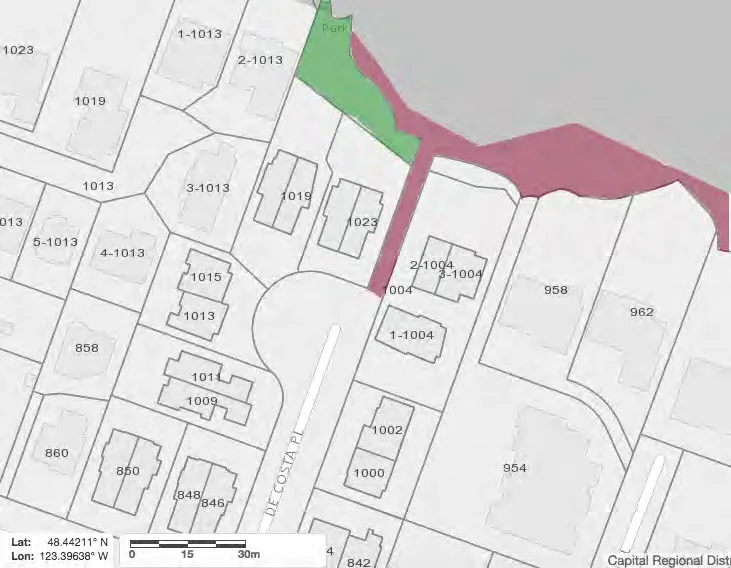
Figure 2.0 – CRD Map: De Costa Place Figure 2.0 is a map of the end of road access point at De Costa Place in Esquimalt. The area shaded green is zoned as a park, while the areas shaded maroon are public lands belonging to the municipality (CRD Maps)
SITE 1 – DE COSTA PLACE, ESQUIMALT
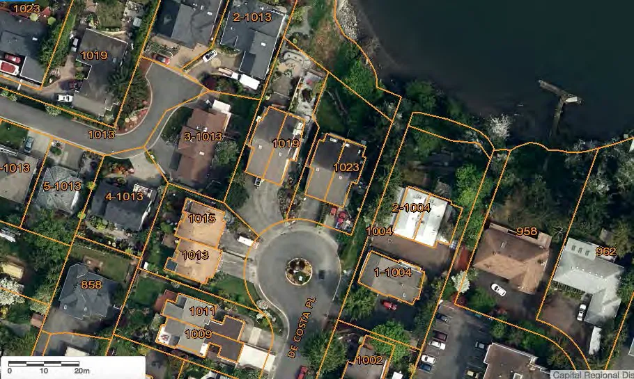
Figure 2.1 – CRD Map Satellite image: De Costa Place The Veins of Life Watershed Society reports that they have been unsuccessfully voicing concerns to Saanich about public access to this access point for years. The access point is located at the end of De Costa Place, Esquimalt. It appears to be about 4.7 metres wide, running from the end of De Costa down to the water. (CRD Maps)
SITE 1 – DE COSTA PLACE, ESQUIMALT
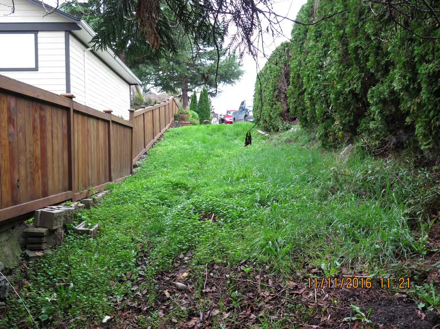
Figure 2.2 – De Costa Place: facing south Figure 2.2 was taken about a third of the way down the access and was taken facing south, back towards the end of De Costa Place (Lat/Lon: 48.442755, -123.395101).¹⁵
¹⁵ All locations and lat/long coordinates can be verified using Google Maps.
SITE 1 – DE COSTA PLACE, ESQUIMALT
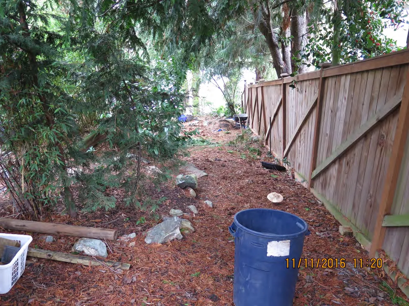
Figure 2.3 - De Costa Place: facing north Figure 2.3 was taken from the same place as the Figure 2.2 (Lat/Lon: 48.442755, -123.395101), facing the opposite direction. It appears to us that the municipality may have failed to take action to prevent the encroachment of private landowners. By our estimation, the approximate width of the public access should be from the fence to the white crate on the left of the picture. However, one can see that a private garden has been extended into the path, apparently blocking the access point. The picture below shows how the access appears to be blocked by the garden extensions.
SITE 1 – DE COSTA PLACE, ESQUIMALT
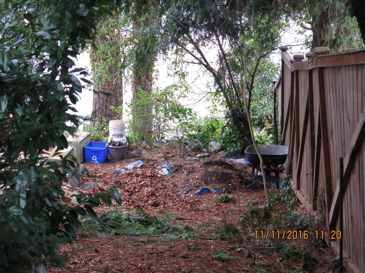
Figure 2.4 - De Costa Place: same location as Figure 2.3 Figure 2.4 was taken from the same spot as Figures 2.2 and 2.3. By our estimation the public access should extend from the fence on the right of the image to the stone block to the left of the recycling bin on the left of the image (approximately). However, this access appears to be blocked by the shrubbery, topsoil, wheelbarrow and bins that appear to be part of a garden extension.
SITE 1 – DE COSTA PLACE, ESQUIMALT
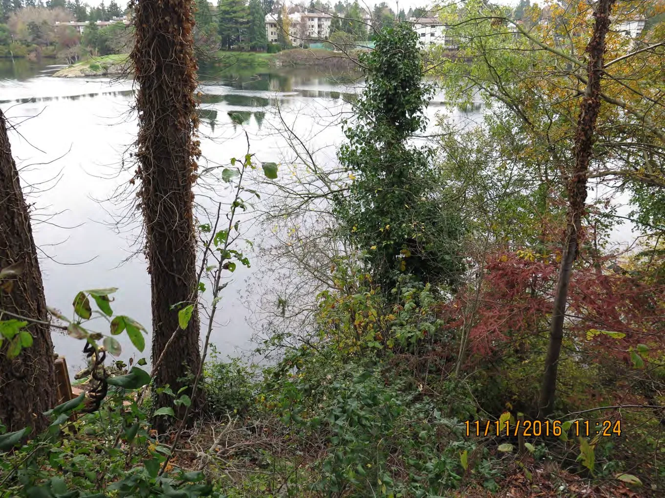
Figure 2.5 - De Costa Place - topsoil piles (facing North) Figure 2.5 was taken from where the topsoil piles in Figure 2.4 were located and is facing north (Lat/Long: 48.442844, -123.395060). The image faces the waterfront. If our calculations are correct, a cleared path and municipal signposting could grant the public access to this prime piece of public waterfront – which currently appears to the casual observer to be private property.
SITE 1 – DE COSTA PLACE, ESQUIMALT
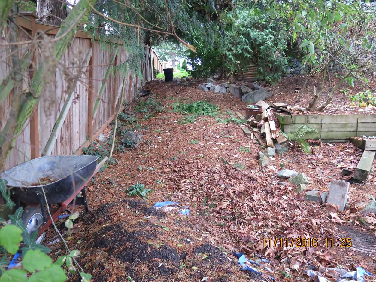
Figure 2.6 - De Costa Place - topsoil piles (facing South) Figure 2.6 is taken from the same location as Figure 2.5, facing the opposite direction (South). Here one can get a better view of how what appears to be a garden extension, in the form of topsoil, a wheelbarrow, garden stones and a bin in the background. This creates the impression that this is all private property. However, according to our calculations the public access should extend from the fence on the left side of the image to about the left-most stone in the line of stones on the right side of the image (approximately).
Are we correct in our interpretation of the above images and map?
SITE 2 – ARCADIA STREET, ESQUIMALT
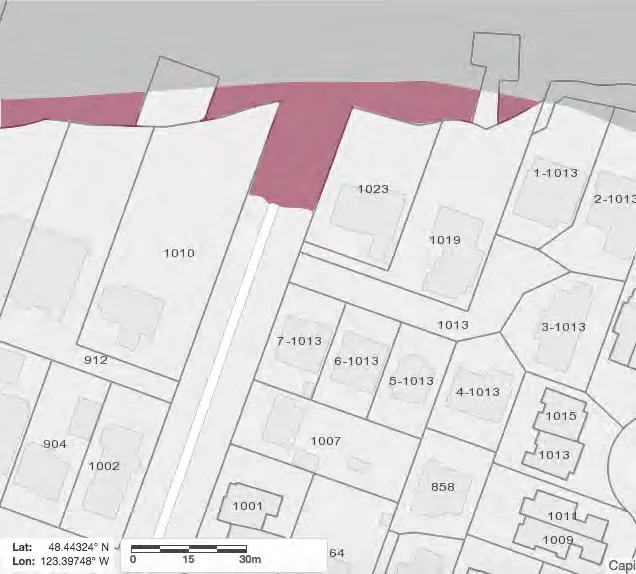
Figure 3.0 - CRD Map: Arcadia Street Figure 3.0 is a map of the public access point at the end of Arcadia Street in Esquimalt. The area shaded maroon is public waterfront land, belonging to the municipality (CRD Maps).
SITE 2 – ARCADIA STREET, ESQUIMALT
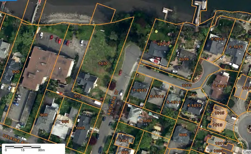
Figure 3.1 - CRD Map Satellite image: Arcadia Street The Public Access point at Arcadia is one block west of the one at De Costa. The Veins of Life Watershed Society had built a path on the public access in the 1990s. However that path no longer exists, and the access point has apparently become a dumping ground for garden clippings, waste and other litter. Furthermore, one can see when comparing Figure 3.1 with Figure 3.10 that a garden appears to have been extended into the public access. (CRD Maps)
Document Images
(8)