Protecting Waterfront Parks
A detailed survey report identifying private encroachments, unpermitted structures (docks, fences), and access barriers at public waterfront sites in Esquimalt and Saanich.
SITE 2 – ARCADIA STREET, ESQUIMALT
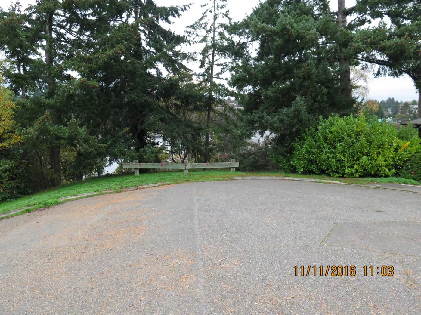
Figure 3.2 - Arcadia Street: mid-point of cul-de-sac (facing North)
Figure 3.2 is taken from (Lat/Long: 48.443079, -123.396854) facing north from the mid-point of the cul-de-sac seen in the aerial photograph depicted in Figure 3.1. By our estimation, the public access point here is 18-metres wide and extends from one side of the image to the other (covers the entire frame).
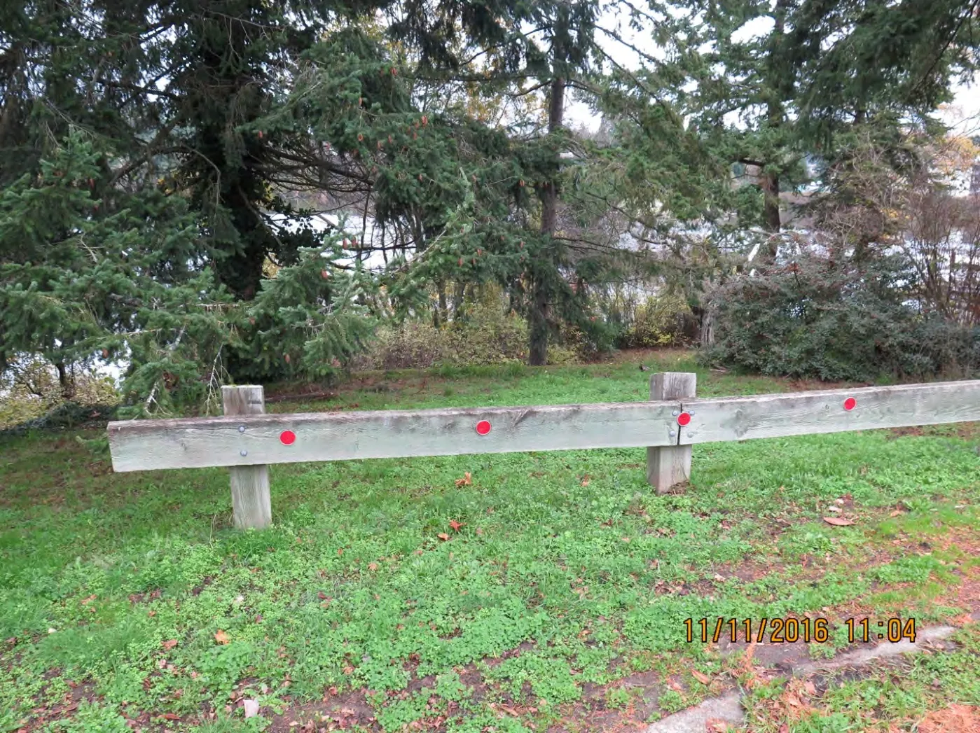
Figure 3.3 - Arcadia Street: end of cul-de-sac
Figure 3.3 is taken from the end of the cul-de-sac (Lat/Long: 48.443173, -123.396832), right in front of the barrier at the end of the road seen in Figure 3.2. All the land covered by the image is public, by our estimation.
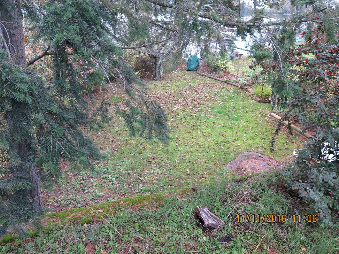
Figure 3.4 - Arcadia Street: other side of barrier (facing Northeast)
Figure 3.4 is taken from the other side of the barrier facing Northeast (Lat/Long: 48.443205, -123.396778). It depicts land that should apparently form part of the public access -- however, it appears to have been turned into a residential garden. This may be checked by looking at the aerial shot in Figure 3.1 where on the east side of the public access one can see what looks like a garden extension.
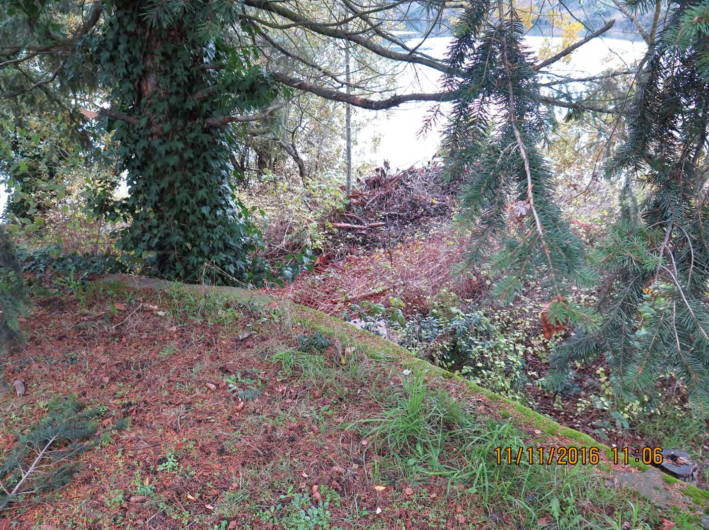
Figure 3.5 - Arcadia Street: facing Northwest (same location as Figure 3.4)
Figure 3.5 was taken from the same location as Figure 3.4, facing northwest, and depicts what appears to be the dumping of residential garden waste. This appears to block off a significant portion of the public access.
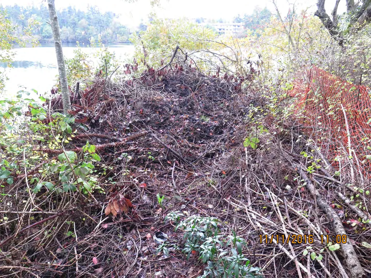
Figure 3.6 - Arcadia Street: facing North
Figure 3.6 was taken facing due North (Lat/Long: 48.443241, -123.396797) and depicts a close up shot of the dumping of garden waste referred to in the previous photograph.
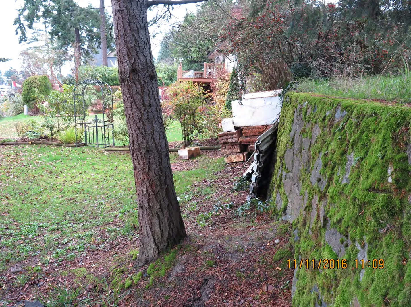
Figure 3.7 - Arcadia Street: facing East
Figure 3.7 was taken facing East (Lat/Long: 48.443244, -123.396771). It depicts what appears to be a residential garden extended into the public access point. By our estimation, the property line that marks the boundary of the public land is on the other side of those flowerbeds and gate. This can be seen in the aerial shot (Figure 3.1), where on the East side of the access there appears to be a lawn and some kind of structure erected on the public land. The location of the structure in Figure 3.1 appears to correspond to the location of the gate and flowerbeds in Figure 3.7. Are we correct in that interpretation?
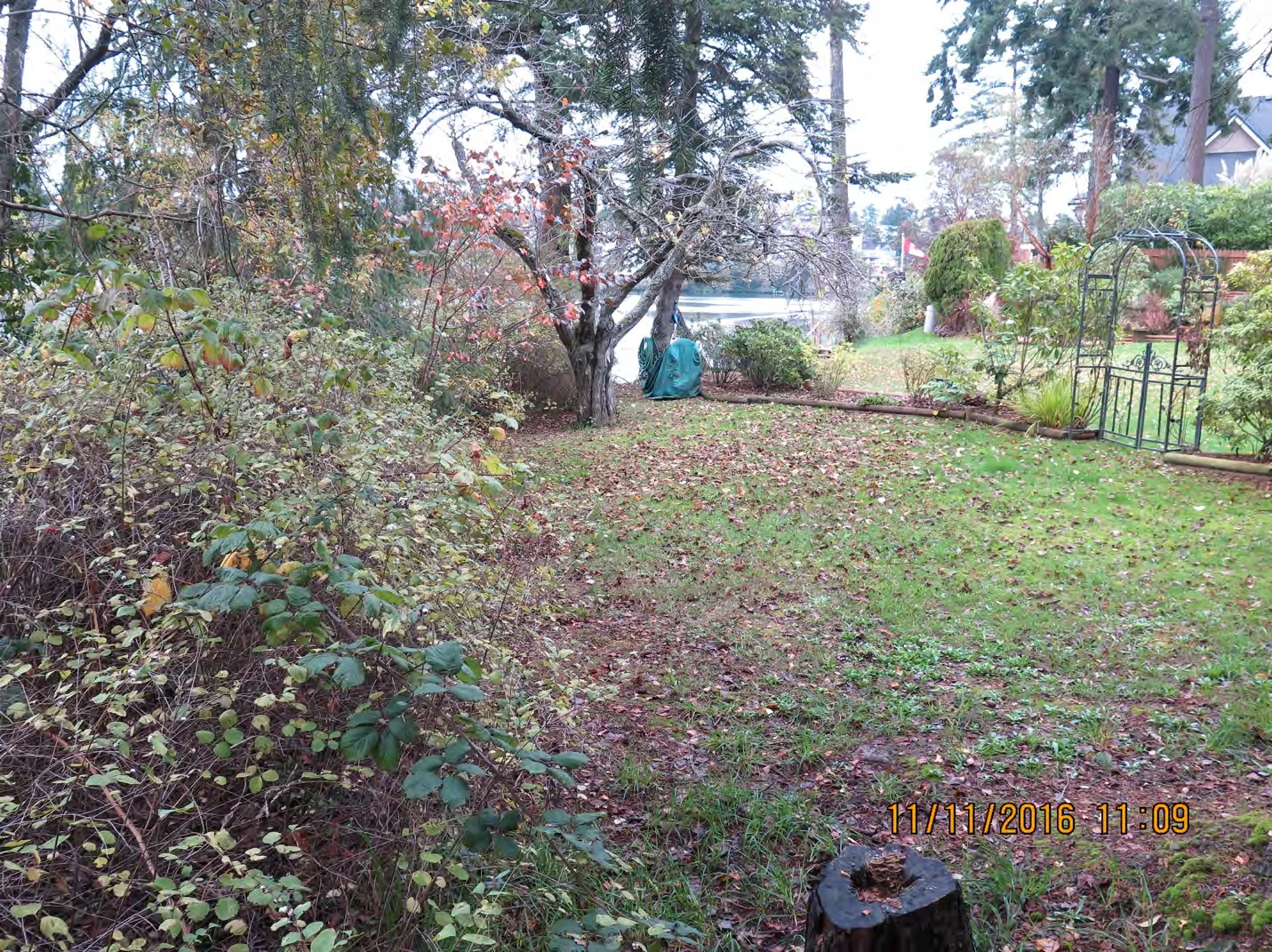
Figure 3.8 - Arcadia Street: same location as 3.7
Figure 3.8 was taken from the same location as Figure 3.7 and similarly shows how a residential garden appears to have been extended into the public land. Here one sees a clearer view of the gate and flowerbeds referred to in the description for Figure 3.7.
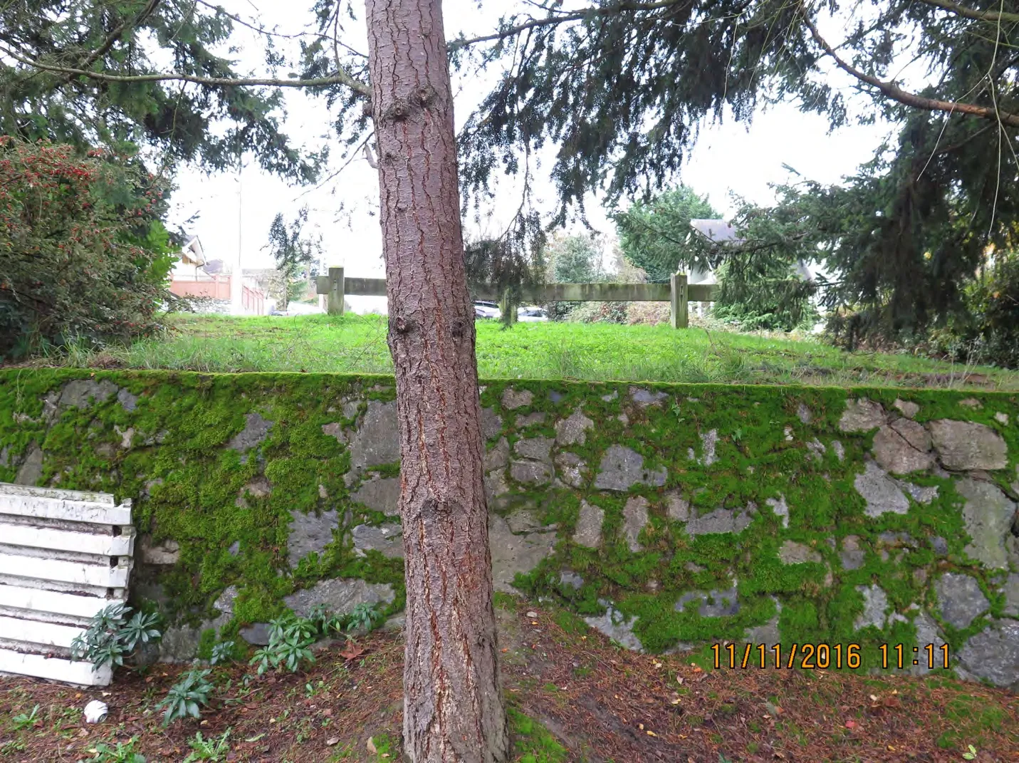
Figure 3.9 - Arcadia Street: facing South
Figure 3.9 was taken from the same location as Figures 3.7 and 3.8 and faces South towards the cul-de-sac at the end of Arcadia Street -- which is on the other side of the barrier seen behind the tree in foreground of this Image. By our estimation, everything in frame should be public land. However, one can see what appears to be some form of residential waste (a white metal covering) on the bottom left hand corner of the image.
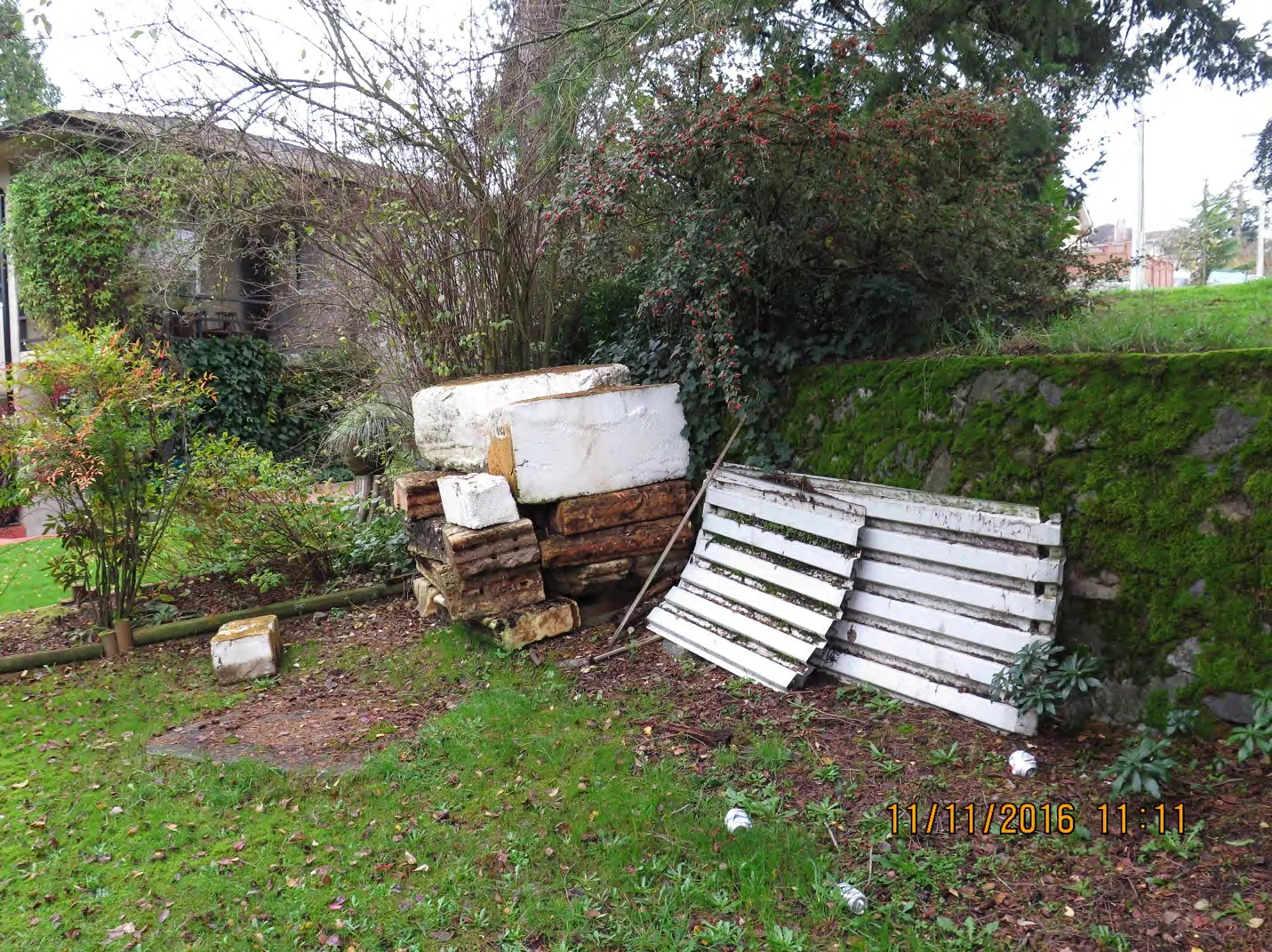
Figure 3.10 - Arcadia Street: facing East
Figure 3.10 was taken from the same location as Figure 3.9 but facing east. This photo depicts a clearer shot of the residential waste from Figure 3.9 and also depicts a wood pile right next to it. Both are apparently on public land and along with the gate, flowerbeds and lawn extension lend an overall appearance of private property -- when in fact much of the land is public, by our estimation. See Figure 3.1 where the property line appears to be on the other side of the garden bed on the left side of the picture. Are we correct in this interpretation?
SITE 3 – GRANGE ROAD, SAANICH
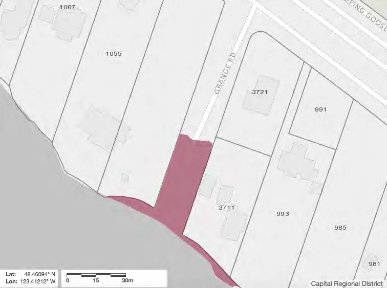
Figure 4.0 - CRD Map: Grange Road
Figure 4.0 is a map of the public access point at the end of Grange Road in Saanich. The area shaded maroon is public waterfront land, belonging to the municipality (CRD Maps).
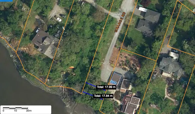
Figure 4.1 - CRD Map Satellite image: Grange Road
Figure 4.1 depicts an aerial shot of the end of road access point at Grange Road in Saanich. The end of road public access is approximately 18-metres wide and from the aerial shot, one can clearly see that the end of the paved road itself is in fact public. (CRD Maps)
Are we correct on this?
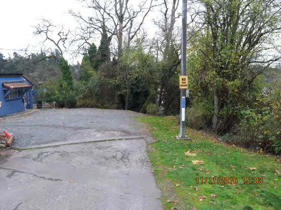
Figure 4.2 - Grange Road: facing South
Figure 4.2 was taken facing south (Lat/Long: 48.461039, -123.412186) and depicts the end of Grange Road. By our estimation, the public access extends from the right of the blue building on the left side of the photograph all the way to the right edge of the photograph itself. One can see that on the pole in middle of the image which is clearly in public land there is a sign that says ‘No Turn Arounds’ and a house number, making it appear as though everything beyond that point is private property when it is in fact public, according to our reading.
Is this correct?
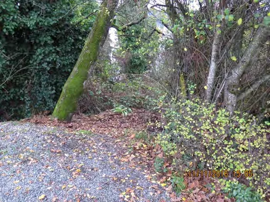
Figure 4.3 - Grange Road: facing South
Figure 4.3 was taken facing South (Lat/Long: 48.460970, -123.412232) at the end of Grange Road facing towards the water, just to the left of the lamppost in the previous image. It depicts what could be made into a public municipal pathway down to the water, if we are correct.
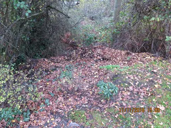
Figure 4.4 - Grange Road: facing West
Figure 4.4 was taken from the same location as Figure 4.3 at the end of Grange Road, but facing west. It depicts what appears to be the dumping of garden clippings on what is – by our estimation -- public land in the middle of the end-of-road access point.
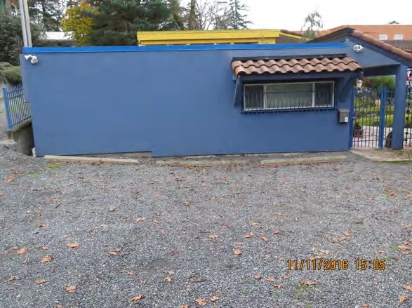
Figure 4.5 - Grange Road: facing East
Figure 4.5 was taken from the same spot as Figures 4.4 and 4.3, but facing east. From the aerial shot in Figure 4.1, one can see how the property line is within centimetres of the blue building. The three parking stalls, along with the “No Turn Around” sign and house number on the lamppost depicted in Figure 4.2 contribute to the impression that this is all private land. However figures 4.0 and 4.1 indicate that it is part of the end of a public road, in our estimation.
Are we correct in our interpretation of this public access point?
Site 4 - Glenwood Avenue, Saanich
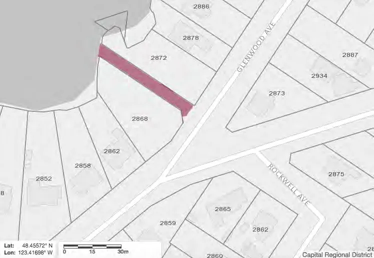
Figure 5.0 - CRD Map: Glennwood Road
Figure 5.0 is a map of the public access point just off of Glenwood Avenue near its intersection with Admirals Rd in Saanich. The area shaded maroon is public waterfront land, belonging to the municipality (CRD Maps).
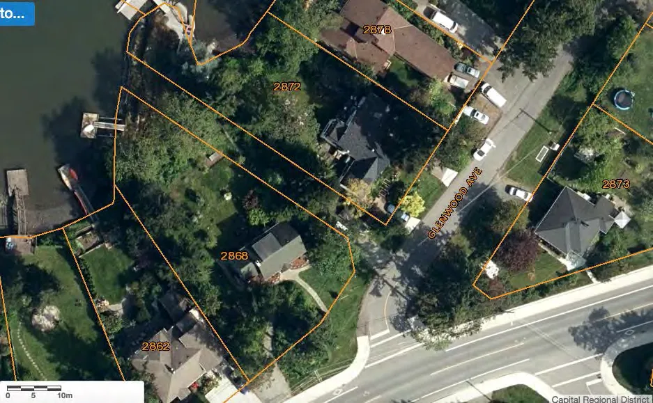
Figure 5.1 - CRD Map Satellite image: Glenwood Road
Figure 5.1 is an aerial shot of the public access point on Glenwood Ave, just off of Admirals Rd. This access point reportedly used to be a road (Garry Road), and private encroachment at this location was identified as a cause for concern in the 1999 Victoria Natural History Society Report.16 However, Garry Road is no longer in the CRD maps database. There appear to be structures at its intersection with Glenwood Avenue blocking access to the public waterfront. (CRD Maps)
16 Victoria Natural History Society Greenways Inventory Saanich Rights of Way that Have Greenway Potential (March 1999), Saanich, District of Saanich Archives (SROW Project Master)
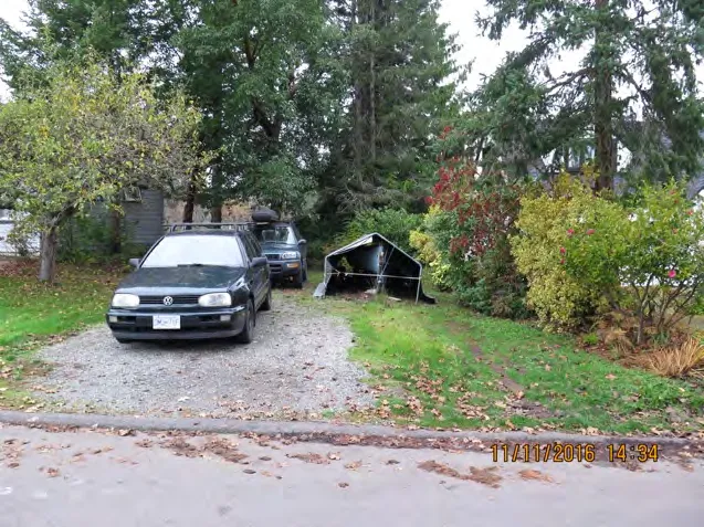
Figure 5.2 - Glennwood Avenue: facing West
Figure 5.2 was taken facing west and depicts what apparently should be the public access point (Lat/Long: 48.455746, -123.416763). According to our reading of the aerial shot, the access should be approximately 6-metres wide -- and extend from about 1 metre left of the forest green vehicle on the left side of the image to about 1 metre to the right of the tent structure. From this image, the public access point appears to have been made into a driveway. Is our interpretation correct? Is there an explanation?
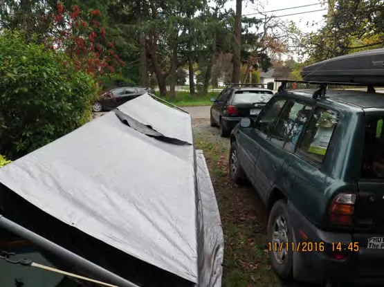
Figure 5.3 - Glennwood Avenue: facing East
Figure 5.3 was taken facing east facing Glenwood Avenue (Lat/Long: 48.455804, -123.416905) from the middle of the apparent public access. By our estimation, the access should extend 3 metres to either side of the point where this photo was taken. The two vehicles and tent structure covering a boat make it appear as though this is part of a private property, when our reading of the aerial image and maps indicate it is public.
Are we correct?
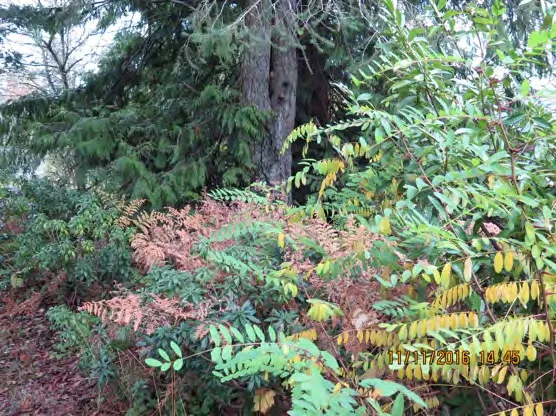
Figure 5.4 - Glennwood Avenue: facing West towards water
Figure 5.4 was taken facing west towards the water approx. three fifths of the way down the apparent public access. It depicts vegetation that block access to the water (Lat/Long: 48.455935, -123.417143).
SITE 5 - RHODA LANE (BETWEEN SHIRLEY AND FORSHAW), ESQUIMALT
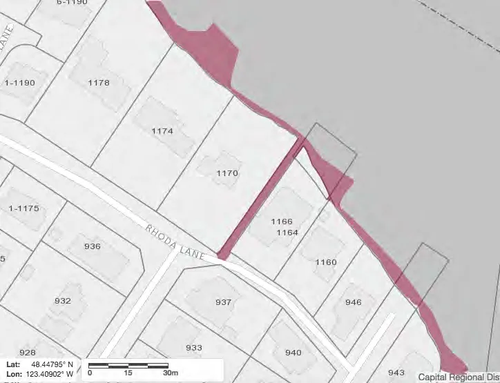
Figure 6.0 - CRD Map: Rhoda Lane
Figure 6.0 is a map of the public access point just off of Rhoda Lane in Esquimalt between its bisections with Shirley Rd and Forshaw Rd. The area shaded maroon is public waterfront land, belonging to the municipality (CRD Maps).
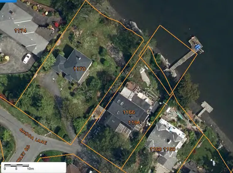
Figure 6.1 - CRD Map Satellite image: Rhoda Lane
Figure 6.1 is an aerial photo of a public access point on Rhoda Lane that is just East of its intersection with Shirley Road. The public access point should apparently be about 3 metres wide. It also appears that a structure has been put up in the middle of the access point about a quarter of the way between the lane and the waterfront. (CRD Maps)
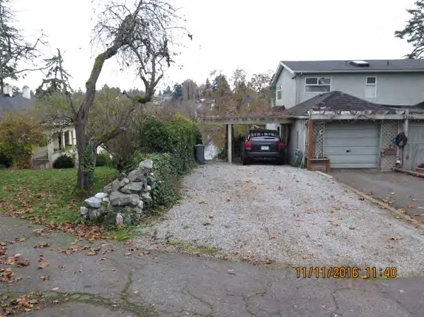
Figure 6.2 - Rhoda Lane: facing North
Figure 6.2 was taken facing North (Lat/Long: 48.447771, -123.409056) from the road and depicts what appears to be the public access. By our reading of the map at Figure 6.0 and aerial shot Figure 6.1, the public access should extend from about the middle of the stone wall on the left side of the picture to 3/5ths of the way of across the driveway. However, it would appear that a private structure (car cover) has been built on the public access.
Are we correct in this interpretation?
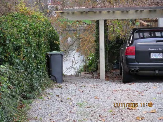
Figure 6.3 - Rhoda Lane: same as 6.2
Figure 6.3 was taken from the same place as Figure 6.2 and depicts a close up of the apparent public access -- which according to our reading of the aerial shot (Figure 6.1) should extend from the hedge to the right side of the tail light of the vehicle. (By our estimation.) It appears that this public land now forms part of a private driveway. Are we wrong in this interpretation?
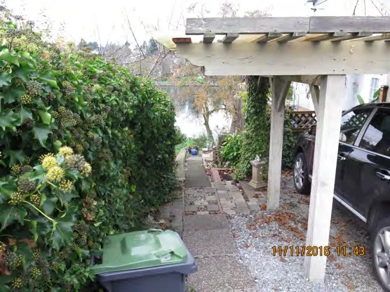
Figure 6.4 - Rhoda Lane: facing North
Figure 6.4 was taken facing the same way as the preceding images, North (Lat/Long: 48.447884, -123.408971). Again, by looking at the aerial shot, our estimation is that the public access should extend approximately from the hedge to the vehicle. However, again the public access appears to form part of someone’s private property, with a pathway, driveway and compost bin.
Are we correct in this interpretation?
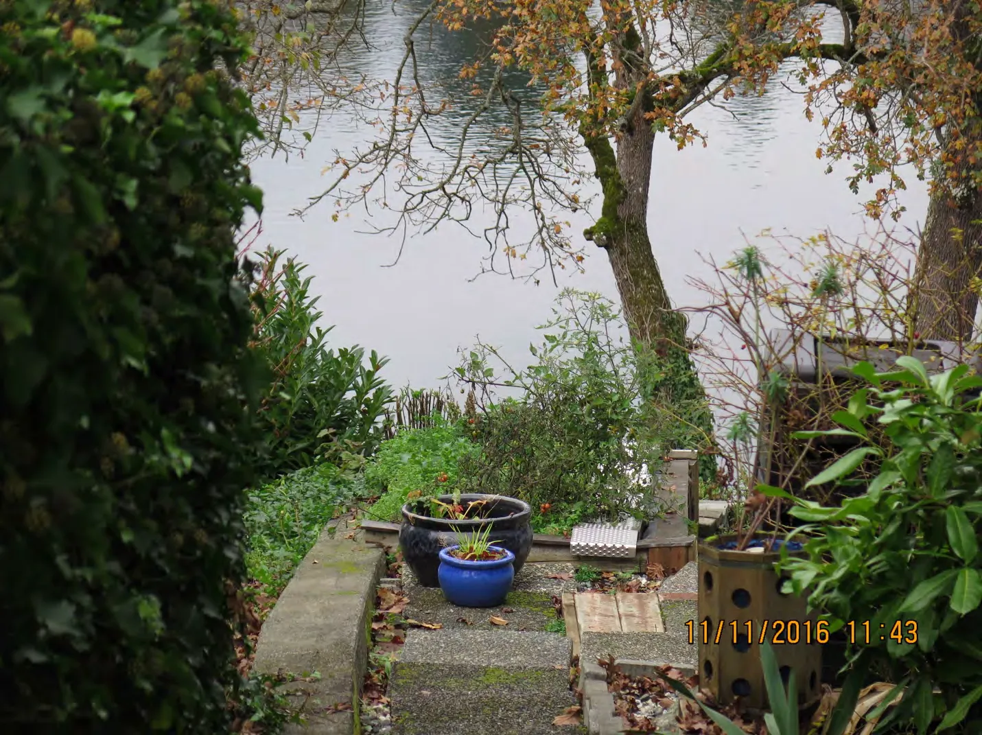
Figure 6.5 - Rhoda Lane: facing North
Figure 6.5 was taken from the same place as Figure 6.4 and shows a close up of some potted plants that can be seen in that image. This path and potted plants at the apparent public access point create the appearance that this is private property. Are we correct in our interpretation?
SITE 6 - MESHER PLACE, ESQUIMALT
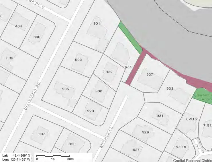
Figure 7.0 - CRD Map: Mesher Place
Figure 7.0 is a map of the public access point at the end of Mesher Place in Esquimalt. The area shaded maroon is public waterfront land, belonging to the municipality (CRD Maps)
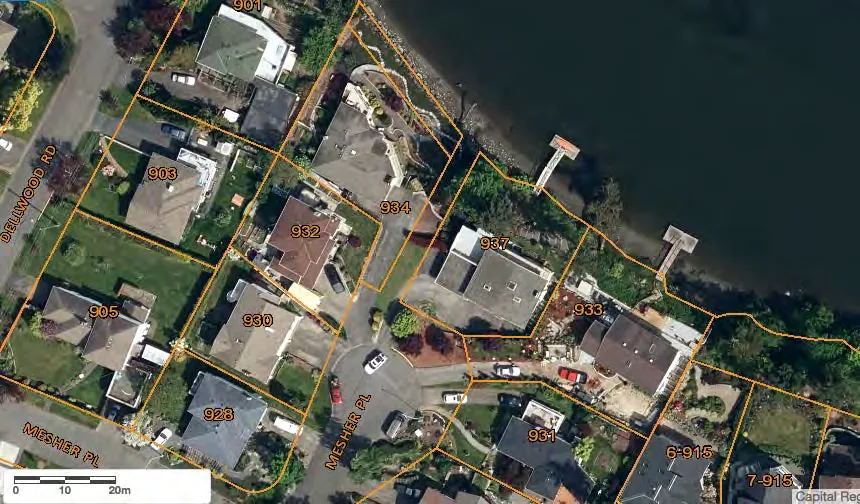
Figure 7.1 - CRD Map Satellite image: Mesher Place
Figure 7.1 is an aerial shot of what should be a public access point at the end of Mesher Place in Esquimalt. The public access is located at the end of the cul-de-sac between properties 934 and 937 -- and is 4.5 metres wide leading down to the waterfront. As can be seen from this aerial shot, there appears to be something blocking the apparent public access point. (CRD Maps)
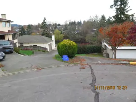
Figure 7.2 - Mesher Place: facing north
Figure 7.2 was taken at the end of the cul-de-sac facing north towards the waterfront (Lat/Long: 48.449147, -123.414279). The green hedges in the centre of the photograph can be seen in the aerial shot as well (just above the white vehicle) and are directly in front of the beginning of the apparent public access. There is no municipal signage, so the access blends in with the surroundings and appears to form part of private property.
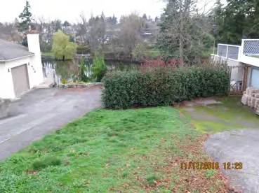
Figure 7.3 - Mesher Place: behind shrubbery
Figure 7.3 was taken from behind the green bushes/shrubbery in Figure 7.2 (Lat/Long: 48.449271, -123.414258). The access should apparently be 4-metres wide and go right through the reddish green hedge in the middle of the photograph, which can also be seen in the aerial shot as blocking the public access. Again, this creates the appearance that this is private property when the aerial shot shows that it is public, by our estimation.
Are we correct in our interpretation?
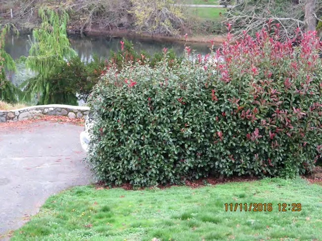
Figure 7.4 - Mesher Place: facing north
Figure 7.4 was taken facing North from the same location as Figure 7.3 and depicts the reddish green hedge that is in the middle of the apparent public access depicted in Figure 7.3. One can make out the rear of a white vehicle, which apparently would be blocking the public access. As with the other examples so far, this contributes to the impression of public land as being private.
Are we correct in identifying a problem here?
SITE 7 - MURRAY DRIVE, ESQUIMALT
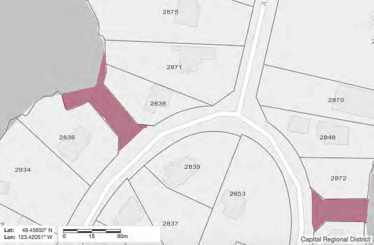
Figure 8.0 - CRD Map: Murray Drive
Figure 8.0 is map of the public access point that is west of the intersection of Ashley Road and Murray Drive. The area shaded maroon is public waterfront land, belonging to the municipality. As part of this project we surveyed the access point on the left side of this picture. (CRD Maps)
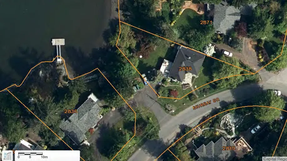
Figure 8.1 - CRD Map Satellite image: Murray Drive
Figure 8.1 is an aerial shot of the same public access point between 2836 and 2838 Murray Drive. The public access point is 12-metres wide. Encroachment at this site was alleged in a 1999 Victoria Natural History Society Report17, indicating that there has been public concern about this access point for more than 15 years. (CRD Maps)
17 Victoria Natural History Society Greenways Inventory Saanich Rights of Way that Have Greenway Potential (March 1999), Saanich, District of Saanich Archives (SROW Project Master)
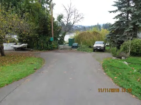
Figure 8.2 - Murray Drive: facing west
Figure 8.2 was taken from Murray Rd facing west (Lat/Long: 48.456688, -123.420366) and depicts the end of the end of road public access, which based on the previous aerial image extends from the truck on the right side of the picture to 2 metres to the left of the wooden post with the green box on it in the middle left of the picture. (By our estimation.) In the middle of the picture is a public utility box.
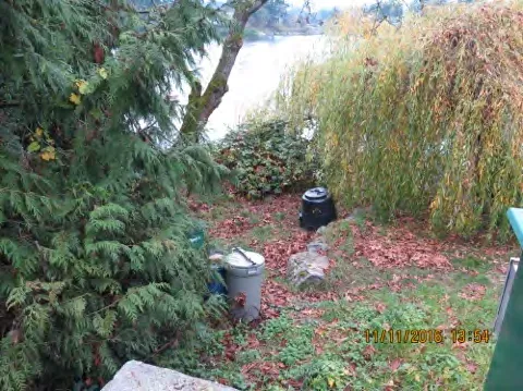
Figure 8.3 - Murray Drive: facing west from utility box
Figure 8.3 was taken facing west (Lat/Long: 48.456820, -123.420600) from behind the utility box depicted in Figure 8.2. Everything covered in the shot is apparently on public land, in our estimation. However, the garbage bin, compost bin and garden stones (in the middle of the image) create the impression that it is private land.
Are we correct?
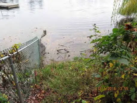
Figure 8.4 - Murray Drive: facing west from end of public access point
Figure 8.4 was taken facing west (Lat/Long: 48.456891, -123.420698) from the end of the public access point and depicts the end of the public access to the water.
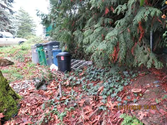
Figure 8.5 - Murray Drive: facing east
Figure 8.5 was taken from the same place as Figure 8.4, but facing east. In our estimation, everything in frame is on public land, as we can see the green box from the wooden post shown in Figure 8.2. However, we can see that a recycling/compost/garbage station, a ladder and some discarded fill create the impression that it is on private land.
Are we correct in our interpretation of this public access point?
SITE 8 - ARAL ROAD, ESQUIMALT
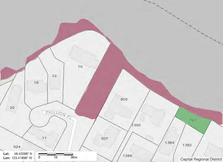
Figure 9.0 - CRD Map: Aral Road
Figure 9.0 is a map of the public access point at the end of Aral Rd in Esquimalt. The area shaded maroon is public waterfront land, belonging to the municipality, while the area that is shaded green is a park (CRD Maps).
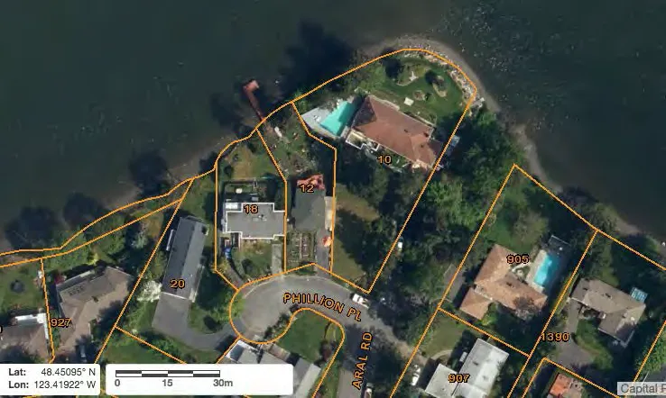
Figure 9.1 - CRD Map Satellite image: Aral Road
Figure 9.1 depicts the end of road access point at Aral Road in Esquimalt, which is about 19-metres wide, between 10 Phillion Place and 905 Aral Rd. One can see from the aerial shot that there are objects/structures on what is actually public land that creates the appearance that it is actually private property. (CRD Maps) Are we correct in that conclusion?
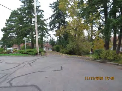
Figure 9.2 - Aral Road: facing North
Figure 9.2 depicts the end of Aral Road facing North (Lat/Long: 48.450883, -123.419102). By our estimation, the public access should extend from the street sign on the left side of the photograph to the smaller white post on the right side of the image. To access the water one must walk to the right of the tree with the light green leaves north towards the water. Again, it is not clearly signposted and the surroundings lend the impression that it is private property.
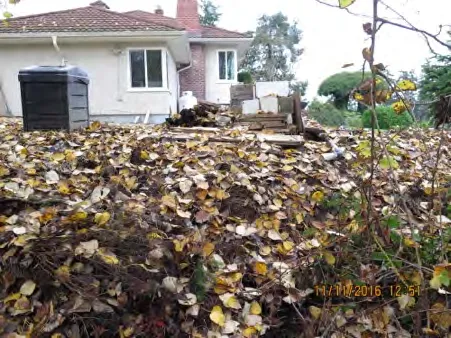
Figure 9.3 - Aral Road: facing West
Figure 9.3 was taken in the middle of the access point facing west (Lat/Long: 48.451317, -123.418726) towards 10 Phillion Place. It depicts garden clippings that have apparently been dumped on the public land as well as some construction debris. The black bin is also apparently on public land, creating the impression that it is private. By our estimation, the public land begins about a metre to this side of the house. Some of the structures (debris) are also apparently visible in the aerial shot. Also we measured the width of the public access as being 10 metres when it should have been approximately 19 metres.
Are we correct in our interpretation of this public access point?
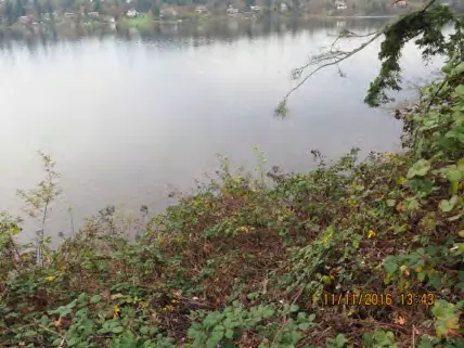
Figure 9.4 - Aral Road: facing Northeast
Figure 9.4 was taken facing northeast (Lat/Long: 48.451292, -123.418633) and depicts the end of the public access – a place from which a person could launch a small boat.
SITE 9 - GLEN VALE ROAD, ESQUIMALT
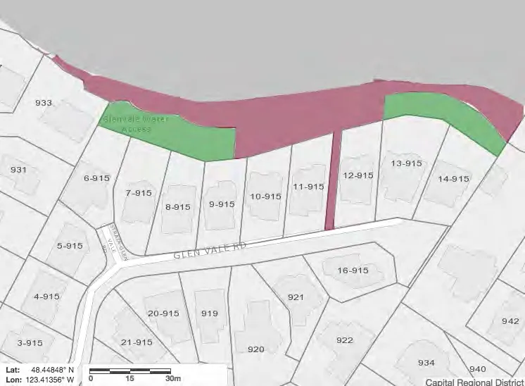
Figure 10.0 - CRD Map: Glen Vale Road
Figure 10.0 is a map of the public access point near the end of Glen Vale Rd in Esquimalt. The area shaded maroon is public waterfront land, belonging to the municipality, while the areas that are shaded green are parks (CRD Maps).
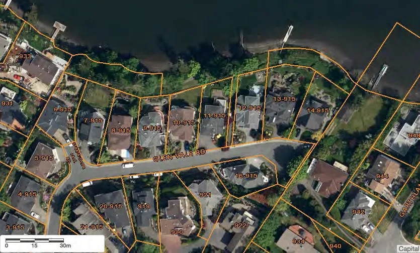
Figure 10.1 - CRD Map Satellite image: Glen Vale Road
Figure 10.1 is an aerial shot of the public access point at Glen Vale Road. The public access point is well marked in between properties 11-915 and 12-915 and goes down to a public shoreline that covers the length of six properties to the west and three properties to the east. The (jagged) rectangles between 13-915 to 14-915 and the water and 6-915 to 9-915 and the water are, according to the CRD, zoned as parks. (CRD Maps)
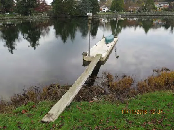
Figure 10.2 - Glen Vale Road: facing North
Figure 10.2 was taken facing north (Lat/Long: 48.449270, -123.411897) and depicts an apparent private dock seemingly attached to the public park land. The dock is visible in the aerial shot (Figure 10.1) where it can be seen as attached to the public land. The plank of wood that connects it to land is seemingly unsecure and could potentially float off into the Gorge where it could pose risks to boaters and impact Gorge hydrology. The dock itself could shade out fish habitat and have other effects.
Has any government approved the establishment of this dock – and its apparent establishment on public land?
Are we correct that the dock is attached to public land?
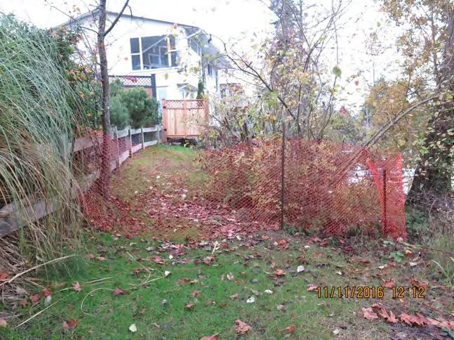
Figure 10.3 - Glen Vale Road: facing West
Figure 10.3 was taken facing West (Lat/Long: 48.449190, -123.413175) and depicts an orange fence that appears to have been placed on public land. The light brown fence represents the western extremity of the public land on the left (west) side of the aerial image. The orange fence has been put up where the property line between 6-915 and 7-915 intersects with the public land. The orange fence appears to block people who might want to continue walking on the public waterfront lands on both sides of the orange fence.
Are we correct on this?
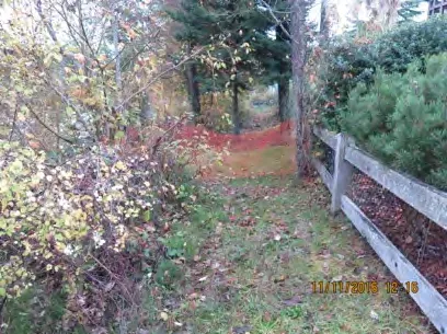
Figure 10.4 - Glen Vale Road: facing East
Figure 10.4 was taken facing east from the other side of the orange fence (Lat/Long: 48.449216, -123.413261). Again we can see how free access across apparently public land (everything to the left of the wooden fence) is blocked by the orange fence.
Should the orange fence be there, since it appears to block access to public waterfront for members of the public enjoying the relatively large public waterfront area on both sides of the orange fence?
Are we mistaken in our concern about whether the orange fence should be there?
Did the municipality put the orange fence there?
If not, who did?
SITE 10 - GARTHLAND ROAD, ESQUIMALT
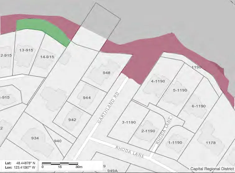
Figure 11.0 - CRD Map: Garthland Road
Figure 11.0 is a map of the public access point at the end of Garthland Road in Esquimalt. The area shaded maroon at the end of Garthland Road is public land belonging to the municipality. (CRD Maps)
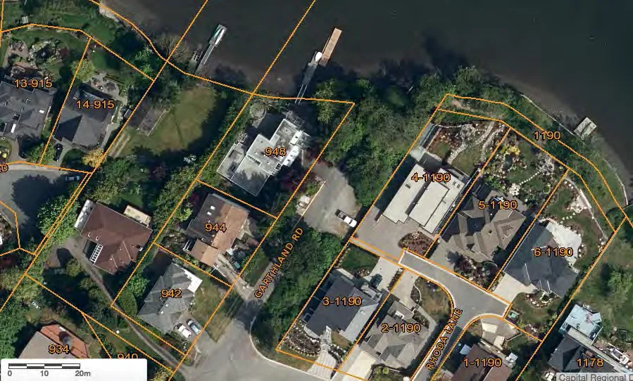
Figure 11.1 - CRD Map Satellite image: Garthland Road
Figure 11.1 is an aerial shot of the public access at Garthland Road in Esquimalt. The public land extends from the end of the road eastwards – separating the 1190 housing development from the water. On the right (east) side along the water there is a dock that appears to be attached to the public land. (CRD Maps)
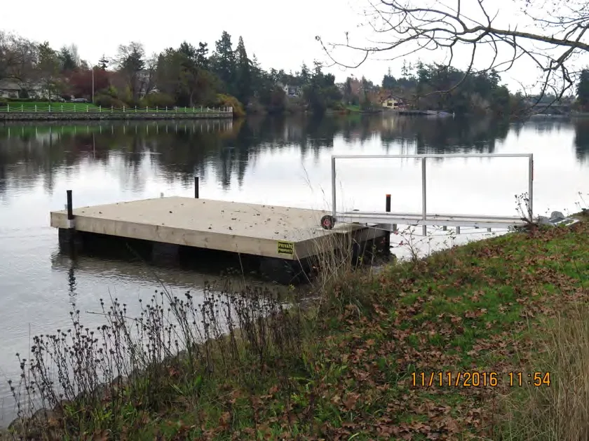
Figure 11.2 - Garthland Road: facing Northeast
Figure 11.2 was taken facing northeast (Lat/Long: 48.448966, -123.409872) and depicts the dock referred to on the previous page that has apparently been built from public land. On the right side of the dock, one can see a yellow “private property” sign, creating the impression that the area around it is private property.
Are we correct in concluding that this dock is not attached to private land, but to public land?
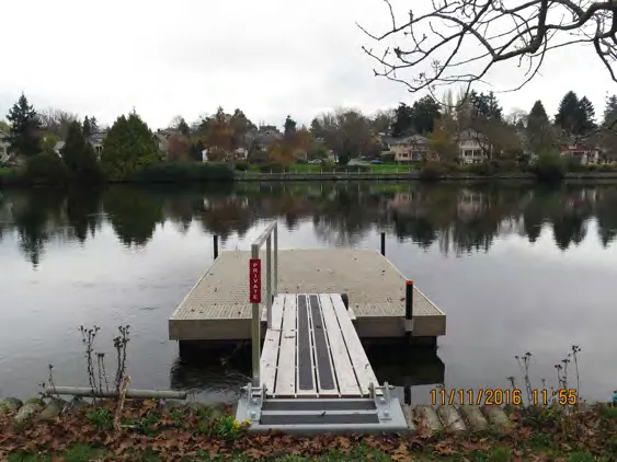
Figure 11.3 - Garthland Road: facing North
Figure 11.3 was taken facing due North (Lat/Long: 48.448916, -123.409785) and depicts the same dock. Again, we can see a red sign that says “private” on it. However, the dock appears to be attached to public – not private -- land, according to our reading of the aerial shot and map (Figures 11.0 and 11.1).
Are we correct?
Has government authorized this dock? If so, why?
SITE 11 - RANKIN ROAD, ESQUIMALT
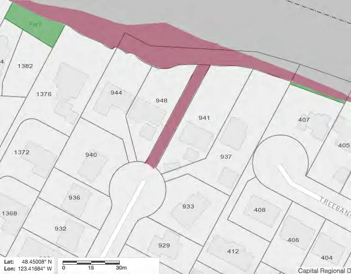
Figure 12.0 - CRD Map: Rankin Road
Figure 12.0 is a map of the public access point at the end of Rankin Road in Esquimalt. The areas shaded maroon represent public land belonging to the municipality. (CRD Maps)
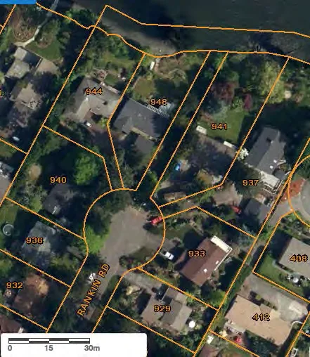
Figure 12.1 - CRD Map Satellite image: Rankin Road
Figure 12.1 depicts a public access point at Rankin Road in Esquimalt, between properties 941 and 948. The public access should be approximately 5 metres wide and extend down to the waterfront. (CRD Maps)
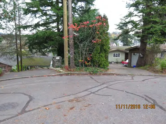
Figure 12.2 - Rankin Road: facing Northeast
Figure 12.2 was taken from the end of Rankin Road facing northeast (Lat/Long: 48.450096, -123.416943). Based on our reading of the aerial shot, the beginning of the public access point would be from about half a metre to the left of the light brown pole to the right edge of the shrubbery. There is no signage, and without a map as a reference, one would think that the public access just forms part of someone’s private property.
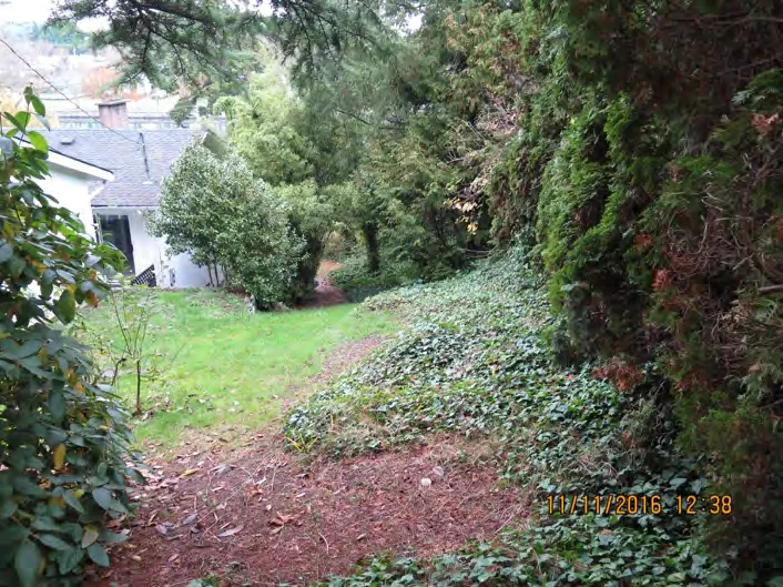
Figure 12.3 - Rankin Road: facing Northeast
Figure 12.3 was taken facing northeast (Lat/Long: 48.450233, -123.416872) from behind the poles depicted in Figure 12.2. By our estimation, the public access should begin at the edge of the lawn and extend into the vegetation on the right side of the image. However, given the lack of signage or maintenance of the public land, it appears that it forms part of someone’s private property.
Is our identification that this is actually a public access correct?
IV. Remedies
Local governments have a number of possible remedies to address some of the issues raised above. For example, local governments may have remedies for encroachment, for cutting vegetation, for depositing objects, or for constructing things on public land.
For example, a municipality might deal with encroachment by suing the encroacher in trespass.18 Alternatively, a number of municipal bylaw provisions might be invoked. For example, in Saanich the Streets and Traffic Bylaw and Parks Management and Control Bylaw prohibit such things as unauthorized construction of structures and depositing of materials on municipal lands.
In addition, the Province and local governments would have possible remedies against private parties if they have built docks and seawalls on public lands without proper authorization.19
If you verify our findings above, and feel that remedial action is necessary, we ask that your government consider the full menu of possible remedies for each situation actually verified that requires remedial action.
However, it is far more important to look forward than to look backwards. That is why we propose the forward-looking recommendations below.
18 Municipalities can pursue a civil claim on parties that encroach on municipal land without express authorization. See District of West Vancouver (Corporation of) v. Liu 2016 BCCA 96 19 Personal communication, Chris Nation, Saanich legal counsel.
V. Conclusion and Recommendations
It would appear that public lands are being compromised, and incrementally lost to private use/encroachment. These public lands include many waterfront parks and green spaces. As we argued in Section II, such waterfront lands are of great environmental, social and economic value to the community.
Therefore, we call on your governments to:
Verify our findings, and make any necessary corrections.
Comprehensively survey the public lands in and around the Gorge and Victoria Harbour to determine all locations where public use and access are being compromised by neighbours. A survey will give a better picture of the scope of the problem -- as well as what steps need to be taken and what resources are needed to address this issue.
Take steps using the remedies at your disposal to eliminate private occupation or compromise of such public lands.
Take steps to eliminate private docks on public lands.
Establish prominent signage, marking and fencing to ensure that it is clear to all that public shorelands are public. In all but one of the access points that we surveyed (Glen Vale Rd), a lack of signage contributed greatly to the impression that the lands were private.
Signage that clearly indicates the location of the public access would make the general public aware that they can use these public access points. Making the public aware of all the different public access points around the Gorge and Harbour will also reduce traffic at the ones where signage is currently in place -- and alleviate parking and traffic issues that may arise at those public access points.
Establish stewardship programs and rules, and monitor the level of public use of these access points. Proper stewardship and conservation of these valuable public assets are key. Stewardship programs can encourage public awareness of the access points and help ensure their proper conservation and protection.
Collaborate with other governments along Victoria Harbour and the Gorge to develop long-term policies to protect public waterfront for public use – and to develop a comprehensive Gorge/Harbour Greenways system.