Stantec Riparian Areas Assessment—2401 Burnside Road - Attachment 3
Environmental memo summarizing the collection and analysis of fish and fish habitat data for watercourses adjacent to the proposed development site.
To: Tyson Loreth, Project Manager, BC Transit From: Mariah Arnold, Ph.D., R.P.Bio., Stantec Consulting Ltd. Date: October 31, 2017 File: 123220971
Reference: Riparian Areas Assessment—2401 Burnside Road, Victoria, British Columbia
INTRODUCTION
At the request of BC Transit, Stantec Consulting Ltd. (Stantec) determined the Stream Protection and Enhancement Area (SPEA) for the three watercourses present at 2401 Burnside Road (the study area), in View Royal, BC. The SPEA was determined following the detailed assessment methods established by Schedule 1 of the Riparian Areas Regulation (RAR), under the Riparian Areas Protection Act. This memo summarizes the collection and analysis of fish and fish habitat data for the three watercourses.
FIELD METHODOLOGY
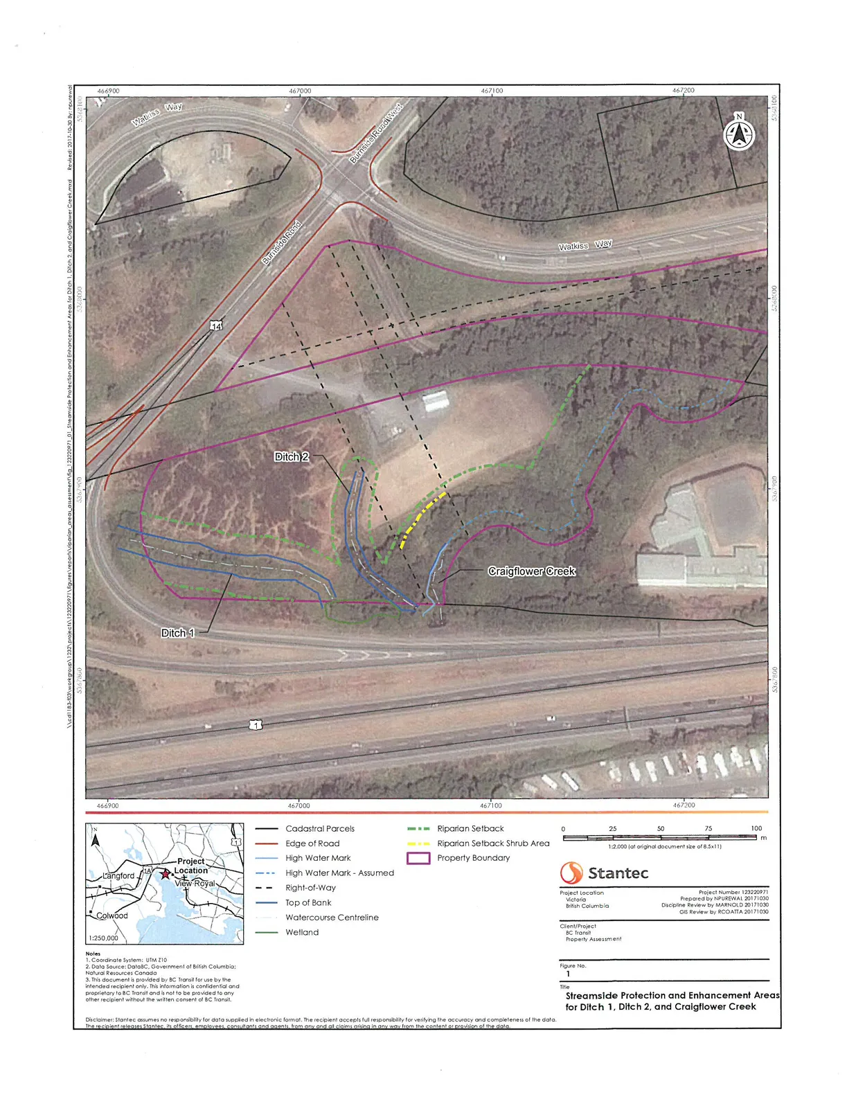
Stantec completed field surveys of Ditch 1, Ditch 2, and Craigflower Creek on September 28, 2017 (Figure 1). The SPEA width for each watercourse was assessed as follows:
- Channel widths of each watercourse were measured by a Stantec qualified environmental professional (QEP) following the Detailed Assessment Methods in the RAR "Assessment Methodology" Schedule. Thick vegetation prevented measurement of all 11 channel widths as indicated in the Detailed Assessment Methods; eight channel width measurements were collected at each watercourse and all channel width measurements were used for calculating the SPEA for individual watercourses.
- Stantec collected data on fish habitat dimensions and characteristics in each watercourse while on site.
- SPEA was determined based on the findings of the site visit and the Detailed Assessment Methods in the Schedule of RAR.
Stantec has not completed a RAR report and has only determined the SPEA. Danger tree assessments, windthrow, slope stability, tree protection during construction, encroachment, and sediment and erosion control have not been performed as part of the SPEA assessment.
RESULTS
DITCH 1
Ditch 1 was a constructed watercourse with a straight channel choked with vegetation. Water levels were very low with flow disappearing underground at one point along the channel and reemerging again downstream. The average of the eight channel width measurements was 5.2 m. The average wetted width was 3.1 m. The gradient was 1% and the reach exhibited riffle-pool morphology, although the low flow resulted in intermittent dry sections. Average residual pool depth was 0.2 m. Bank full depth was 0.5 m.
Water within Ditch 1 appeared stagnant with decaying vegetation. No spawning gravels were observed. Ditch 1 provided moderate quality rearing habitat for juvenile salmonids, with abundant (more than 20%) instream cover (e.g., cattails [Typha latifolia]) and overhanging vegetation (Himalayan blackberry, Rubus armeniacus). Substrate consisted primarily of organics (46%) and fines (40%), which, combined with a lack of riffle habitat (0%), suggests poor food supply for fish. Some moderate overwintering habitat may be provided by some of the deepest pools within the ditch. Poor migration habitat was indicated in the watercourse due to a lack of flow and the presence of isolated, shallow pools. Poor staging habitat for adult salmonids was evident in Ditch 1 due to a lack of undercut banks and limited pool depth. The riparian vegetation consisted of shrubs and young forest approximately 33 m wide on the right bank and >50 m on the left bank. The width of the right bank riparian vegetation was limited by the TransCanada Highway.
Fish presence could not be confirmed for Ditch 1. However, Ditch 1 drains into Craigflower Creek, a known fish-bearing watercourse. Ditch 1 was assumed to be fish bearing for SPEA calculations as a conservative measure. The Zones of Sensitivity (ZOS) for large woody debris (LWD) and bank stability, litterfall and insect drop, and shade are each 10.4 m (two times the average channel width of 5.2 m). Therefore, the overall SPEA for Ditch 1 is 10 m from the surveyed top of the bank, which is the maximum Zone of Sensitivity width for fish-bearing constructed ditches (Figure 1). Where possible, a 2 m wide undeveloped strip should be maintained along the edge of the SPEA for root protection.
Examination of Terrain Resource Information Management (TRIM) and National Topographic System (NTS) mapping showed no indication of a tributary to Craigflower Creek, therefore the SPEA for this watercourse was calculated using the ZOS for constructed ditches as defined by the RAR "Assessment Methodology". However, if information suggesting this watercourse is in fact a stream, a larger SPEA of 15.5 m (calculated as three times the average channel width) would be applicable.
DITCH 2
Ditch 2 consisted of a confined, straight channel containing large amounts of instream vegetation. Water was present in short sections of the surveyed reach in the form of shallow pools. The average of the eight channel width measurements was 3.4 m. The average wetted width calculated in locations where water present was 0.7 m; two of the eight transects were dry. The gradient was 1% and the reach exhibited riffle-pool morphology, although the low flow resulted in dry sections of the watercourse. Average residual pool depth of 0.06 m. Bank full depth was 0.4 m.
No flowing water or spawning gravels were observed within the surveyed reach. Deep pools or undercut banks potentially providing overwintering and staging habitat for adult salmonids were also not observed. Although extensive cover from instream vegetation was present (100%, predominantly as reed canary grass [Phalaris arundinacea]), the lack of water flow, shallow pool depth, and substrate composition (70% organics, 25% fines) indicated poor quality juvenile salmonid rearing habitat. Migration habitat was poor due to the intermittent wetted areas and dense instream vegetation. The riparian vegetation consisted of grasses and shrubs extending more than 50 m on the right bank and 5 m on the left bank. An archery range is present beyond the grass and shrub area.
As with Ditch 1, fish presence could not be confirmed for Ditch 2, but it was assumed to be fish bearing for SPEA calculations as a conservative measure because it drains into Craigflower Creek. The Zones of Sensitivity for large woody debris (LWD) and bank stability, litterfall and insect drop, and shade are each 6.9 m (two times the average channel width of 3.43 m). Therefore, the overall SPEA for Ditch 1 is 6.9 m from the surveyed top of the bank (Figure 1). Where possible, a 2 m wide undeveloped strip should be maintained along the edge of the SPEA for root protection.
CRAIGFLOWER CREEK
Craigflower Creek was an occasionally confined channel with an irregular pattern. The average of the eight channel width measurements was 8.1 m. The average wetted width was 3.3 m. The gradient was 1% and the surveyed reach exhibited riffle-pool morphology with a residual pool depth of 0.2 m. Bank full depth was 1.1 m.
Craigflower Creek provided good quality rearing habitat for juvenile salmonids, with good cover from overhanging vegetation and undercut banks with some woody debris and deep pools. Water flow was continuous throughout the creek, with deep pools connected by shallower run (70%) or riffle (10%) sections. The streambed substrates were predominantly organic material (40%) and fines (40%), which combined with the limited riffle habitat may indicate poor food supply for salmonids. Several sections of exposed gravels were observed in the creek, indicating potential salmonid spawning habitat. Undercut banks appropriate for staging smaller salmonids (e.g., cutthroat trout) were observed along the watercourse and overwintering habitat as deep pools was estimated to be sufficient for juveniles or smaller fish.
Craigflower Creek is known to be fish bearing, with provincial records of coho salmon (Oncorhynchus kisutch), two life forms of cutthroat trout (O. clarki), two life forms of O. mykiss (rainbow and steelhead trout), sculpin (Cottus sp.), and three non-native species¹. Multiple juvenile fish were observed in pools during field work.
A powerline right-of-way (ROW) passes over Craigflower Creek within the study area. Riparian vegetation on the portion of the creek outside of the powerline ROW consisted of mixed coniferous and deciduous trees at the pole-sapling and young forest stages and a dense shrub layer (primarily Himalayan blackberry) more than 50 m wide. The site potential vegetation type is treed. The site potential vegetation type for the section of the creek located within the powerline ROW was previously identified as "shrub"². However, results of the field survey and examination of aerial photos suggested that trees were present in this portion of the creek. As a conservative measure, SPEA values based on both shrub and tree vegetation types were calculated for the portion of Craigflower Creek within the powerline ROW.
Based on the findings of the site visit, Stantec concluded that Craigflower Creek is a riffle-pool stream with site potential vegetation types of "treed" and "shrub" under the Riparian Areas Regulation. For the treed area, the Zones of Sensitivity for LWD and bank stability, litterfall and insect drop, and shade were 24.2, 15, and 24.2 m, respectively. Therefore, the overall SPEA for this section of Craigflower Creek is 24.2 m from the surveyed high water mark (See Figure 1). In the portion of the creek categorized as "shrub", the Zones of Sensitivity for LWD and bank stability, litterfall and insect drop, and shade were 20, 15, and 5 m, respectively. The overall SPEA for this section of Craigflower Creek is 20 m from the surveyed high water mark (See Figure 1). Where possible, a 2 m wide undeveloped strip should be maintained along the edge of the SPEA for root protection.
WETLAND
Based on previous survey results, a wetland was identified on the southern edge of the study area (Figure 1). This SPEA for a wetland is 30 m to the south based on the shade Zone of Sensitivity and 15 m in all other directions. The 30 m SPEA to the south would be outside of the property boundary. The applicable wetland SPEA falls within the SPEA of Ditch 1, Ditch 2, and Craigflower Creek.
¹ BC Ministry of Environment. 2017. Habitat Wizard Streams Report—Craigflower Creek. Accessed October 22, 2017, from http://maps.gov.bc.ca/ess/sv/habwiz/.
² Enkon Environmental Ltd. 2011. VIP71333/77164, View Royal, B.C.—Riparian Areas Assessment. 11 pp.
CLOSURE
We trust the information provided within this technical memo is sufficient for your current needs. If you have any questions, please contact Sandra Nelson.
Regards,
STANTEC CONSULTING LTD.
Mariah Arnold, Ph.D., R.P.Bio. Biologist, Environmental Services
Sandra Nelson, M.Sc., R.P.Bio. Aquatic Ecologist, Environmental Services
Document Images
(5)