DEVELOPMENT PERMIT 2018/01 – 242-244 Island Highway
A detailed planning report on a development permit application for a four-storey, 37-unit multifamily building.
TOWN OF VIEW ROYAL
Planning & Development Report
TO: Committee of the Whole DATE: Sept. 11, 2018 FROM: J. Chow, Senior Planner MEETING DATE: Sept. 18, 2018 FILE NO.: 3060-20-2018/01
DEVELOPMENT PERMIT 2018/01 – 242-244 Island Highway
RECOMMENDATION:
THAT the September 11, 2018 report from the Senior Planner titled “Development Permit 2018/01 – 242-244 Island Highway” be received for information.
CHIEF ADMINISTRATIVE OFFICER’S COMMENTS:
I concur with the recommendation.
DIRECTOR OF DEVELOPMENT SERVICES’ COMMENTS:
I concur with the recommendation.
DIRECTOR OF PROTECTIVE SERVICES’ COMMENTS:
I concur with the recommendation.
DIRECTOR OF ENGINEERING’S COMMENTS:
I concur with the recommendation.
PURPOSE OF REPORT:
To introduce a development permit application for a four storey 37-unit multifamily building with underbuilding and underground parking.
BACKGROUND:
The 1860.5m² site is comprised of two properties, each with single family dwellings to be removed for the proposed development. The site has three frontages as shown in Attachment 1: Island Highway to the south, a 6.0m wide side lane to the west, and a 3.0m wide rear lane to the north that provides pedestrian access to the Glenairlie neighbourhood through Suzanne Place. The property was rezoned to RM-3: Mixed Residential in June 2018. As part of the rezoning, a statutory right-of-way was registered to require a sidewalk along the side lane.
PROPOSAL:
The proposal is for a four storey 37-unit apartment building comprised of 21 one-bedroom units and 16 two-bedroom units as shown in Attachment 3. There would be 36 underground parking spaces and nine underbuilding parking spaces at the rear.
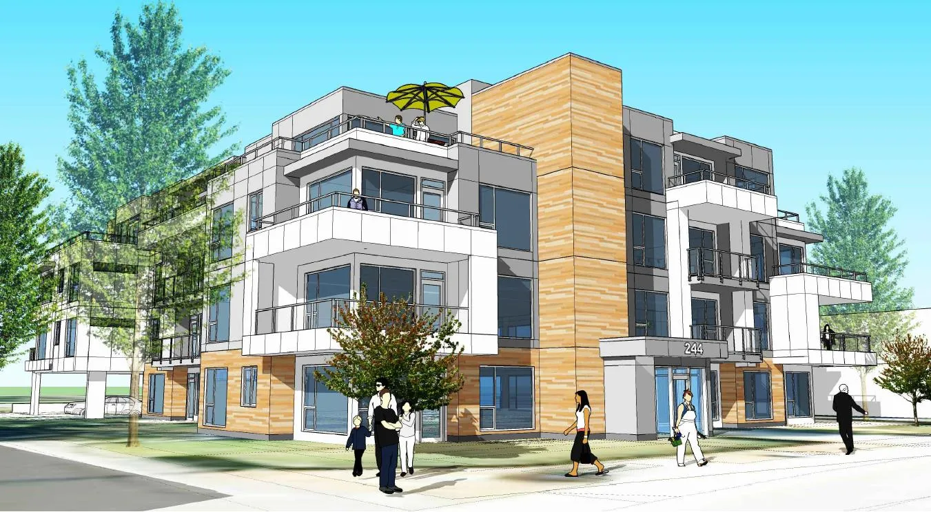
As shown in Figure 1, the design would be contemporary West Coast with exterior materials such as white and grey Hardie panel on the upper floors, cedar siding at the ground level, white metal siding on the balconies, black metal flashing, extensive glazing, and a tower-like staircase that would carry the natural wood elements from the ground floor up the building. A one storey entrance lobby would extend toward the street.
The building would feature balcony projections that are different from floor to floor to provide architectural interest and many visual planes. The top floor would be set back and the building footprint would be barbell shaped to further break up the massing. Landscaping would be focused on the perimeter with smaller ornamental tree species (<25m at maturity) that are suitable for a denser urban context, and native shrubs and groundcover species. Vehicle access would be through the side lane, and the existing driveway on Island Highway would be removed.
ANALYSIS:
There are three principle considerations for this development permit application:
a) How does the proposal address the applicable development permit guidelines? b) How does the proposal meet Zoning Bylaw requirements? c) What additional information should be provided prior to Council consideration of the application?
A. Development Permit Area Guidelines
The site is located in the Mixed Residential (form and character) Development Permit Area. The proposal generally complies with the development permit area guidelines as outlined in Attachment 5. Key points to note include the following:
- Four storey buildings are typically blocky. This design reduces the massing in an effective manner through extensive building articulation with multiple balcony extrusions on the building façade, colour blocking, and large windows.
- The staircase at the building entrance will be finished with cedar and is an architectural element that carries natural wood tones from the ground level up the building for contrast with the cooler white and grey tones of the main building.
- The three ground floor units facing the side lane would have individual front doors for direct access the street to add more life to that frontage.
- Removing the driveway from Island Highway creates more landscape area to improve streetscape. This is welcome because the boulevard contains infrastructure: a bus stop, two BC Hydro transformers, and an underground servicing vault. Further east are Shaw and Telus underground vaults.
The design is largely consistent with the intent of the development permit area guidelines; however, additional considerations include the following:
a. While the central staircase is a striking design element, the black metal reveals (seams) may not be visually substantial enough to break up the blank wall effect. More architectural detail should be considered. b. More roof overhang at the building entrance should be provided for protection from rain. c. The guidelines supports shelter over the visitor bicycle parking outside building entrance. d. An exterior lighting concept should be provided and the fixtures should be “dark skies” friendly. e. The Sustainability Checklist should be submitted to show what measures are proposed for energy and resource efficiency. f. A sign concept detailing the proposed sign locations, materials (e.g. channel letters), illumination, and overall height, width and area for each sign area, even if the only sign proposed is the house number sign. In that case, the specifications can be listed on the elevation plan. g. There should be more garden beds and less lawn in the front yard.
B. Zoning Requirements and Requested Variances
The site is zoned RM-3: Mixed Residential. Table 1 summarizes how the proposal meets the zoning requirements and identifies several variances.
Table 1. Zoning Review
| Zoning Bylaw Requirements (RM-3: Mixed Residential zone) | Proposed | Variance |
|---|---|---|
| Principal Uses | ||
| Residential, Apartment (among other uses) | Residential, Apartment | |
| Lot Density | ||
| a) Lot size, minimum 1500m² | a) 1860.5m² | |
| b) Lot Width, minimum 40m | b) 35m* | b) 5m |
| Lot Density | ||
| a) Floor Space Ratio 1.6:1 with 80% underground parking | a) 1.6 | |
| b) Lot Coverage maximum of 60% | b) 47% | |
| c) Impermeable Coverage maximum of 60% | c) 73%* | c) 13% |
| Building Size | ||
| a) Height – 13.5m maximum | a) 13.0m | |
| b) Building width – 6.0m minimum | b) 18.0m | |
| Siting of Buildings and Structures | ||
| a) Front lot line (Island Highway - Southwest) minimum of 7.5m | a) 4.3m* | a) 3.2m |
| b) Front lot line (Rear Lane - Northeast) minimum of 7.5m | b) 6.8m* | b) 0.7m |
| c) Side lot line (Southeast) minimum of 4.0m | c) 4.2m | |
| d) Flanking lot line (Lane) minimum of 4.0m | d) 4.0m | |
| Projections | ||
| a) Balcony projection into a required setback | a) 0.8 and 1.9m* | a) 0.3m |
| Parking spaces | ||
| a) Studio or One Bedroom – 1 per dwelling unit x 21 = 21 | a) 21 | |
| b) Two Bedroom – 1.5 per dwelling unit x 16 = 24 | b) 28 | |
| c) Three Bedroom or more – 2 per dwelling unit x 0 = 0 | c) 0 | |
| e) maximum of 30% small car spaces | d) 0% | |
| f) Location of parking min. 1.2m from any lot line | e) 2.0m | |
| g) length of small car parking space – minimum 4.8 m | f) n/a | |
| h) maximum cross-slope | g) 7% (20 spaces)* g) 8% (8 spaces) |
g) 1% g) 8% |
| Bicycle Parking | ||
| a) Class 1 (indoor secure) : 1 per unit x 37 = 37 | a) 48 | |
| b) A six-space rack at each entrance of an apartment | b) complies |
* Variance requested
The plans as submitted require variances for lot width, the amount of impermeable surface, building siting, balcony projections, and cross slope of parking spaces.
a. Lot Width
The request to vary the minimum lot width from 40m to 35m can be supported because that is the available width from the two existing lots comprising the site and lot width is sufficient for the proposed development.
b. Impermeable Surface
The request to vary the amount of impermeable surface from 60% to 73% can be supported because it would allow for underground parking and is necessary so that a 1.2m publicly accessible sidewalk can be constructed within the statutory right-of-way along the west edge of the site.
c. Building Siting
The site is technically a through lot, meaning it has two front lot lines: a front lot line to the south along Island Highway and another front lot line to the north along the “rear lane” as shown in Attachment 1. Building siting variances at both lot lines are requested. The request to vary the setback to the south front lot line on Island Highway from 7.5m to 4.3m is to accommodate a one storey building entry and a staircase that runs the height of the building. The entrance would provide a human scale entrance that engages the streetscape. The staircase would be 5.5m from the front lot line and would rise up from the building entry as a cedar faced architectural feature as shown in Figure 1. The rest of the building face would meet siting requirements.
The request to vary the setback to the north front lot line adjacent to the “rear lane” from 7.5m to 6.8m can be supported because the lane frontage is a pedestrian path rather than a roadway. If the lane did not exist, the north lot line would be a rear lot line with a required setback of 7.0m. The rear lane provides additional 3.0m buffer to the parcel at 226 Suzanne Place to a total separation of 9.8m.
d. Balcony Projections
The request to vary balcony projections into required setbacks from 0.5 to 1.9m can be supported as they are on frontages facing public streets and lanes, not the adjoining townhouses at 236 Island Highway. The balconies project 0.8m into the setbacks except for three fourth floor balconies that project up to 1.9m. The balconies would provide usable outdoor living space for the residents and would be architectural features that create visually interesting articulation and character for the building as shown in Figure 1.
e. Cross Slope of Parking Spaces
Variances are requested to increase the permitted parking cross slope from 6% to 7% for twenty underground parking spaces and to 8% for eight surface parking spaces. The cross slopes are due to the slope of the drive aisles. Staff will work with the applicant to determine whether the variances are supportable because a steep cross slope could lead to vehicle damage from doors swinging wide.
C. Additional Information
A review of the application has been completed and further information is required as follows prior to Council consideration:
Development Permit Area Guidelines
a. While the cedar faced central staircase is a striking design element, the black metal reveals (seams) may not be visually substantial enough to break up the blank wall effect. More architectural detail should be considered. b. More roof overhang at the building entrance should be provided for protection from rain. c. The guidelines support shelter over the visitor bicycle parking outside building entrance. If a shelter is to be provided, a variance will be required for the location. d. An exterior lighting concept should be provided. The fixtures should be “dark skies” friendly and noted on the plans. e. The Sustainability Checklist should be submitted to show what measures are proposed for energy and resource efficiency. f. A sign concept detailing the proposed sign locations, materials (e.g. channel letters), illumination, and overall height, width and area for each sign area, even if the only sign proposed is the house number sign. In that case, the specifications can be listed on the elevation plan. g. If fencing is proposed, a locations and a typical design should be shown. h. Adaptable design for accessibility should be considered. i. An energy efficiency standard should be considered. j. The landscaping plan should note that “all landscaping work and plant material shall conform to the most recent edition of the British Columbia Landscape Standard published by the British Columbia Society of Landscape Architects”.
Zoning
k. Confirmation that the vertical clearances are met for underground parking spaces 32 and 33. They are on a level directly below the underground parking ramp. l. Confirmation that parking gradients meet the Zoning Bylaw requirement of 6%. m. Evaluation of the potential impact of proposed parking cross slopes of 7-8% for 28 parking spaces where the Zoning Bylaw requires a maximum of 6%.
Servicing
n. At this time the proponent has not submitted sufficient drawings that allow for Engineering to comment. More information on storm water management and offsite works is required. o. Confirmation that there will be adequate turning radii for large vehicles at the intersection of Island Highway and the lane providing access to the site. p. If an additional transformer is required by BC Hydro, its location should be established in the plans.
The conceptual building and site design otherwise meets emergency access requirements.
NEXT STEPS:
Once the applicant has provided the additional information noted in this report and the issues have been satisfactorily resolved with staff, residents and owners of nearby properties will be notified of a Council meeting to consider the application as required by the Local Government Act and Development Procedures Bylaw No. 730, 2009. The application would be considered at a Council meeting after the October 2018 municipal election.
RECOMMENDATION:
THAT the September 11, 2018 report from the Senior Planner titled “Development Permit 2018/01 – 242-244 Island Highway” be received for information.
ATTACHMENTS:
- Property Location Map
- Letter from Applicant – July 9, 2018 (two pages)
- Architectural plans – Alan Lowe Architects June 25, 2018 (16 pages)
- P1 - Landscape Plan – Lombard North Group, February 19, 2018
- Development Permit Area Guidelines Review, Town of View Royal (seven pages)
Document Images
(5)