Attachment 5: Interface Fire Hazard Assessment - Woodworth Property
Professional assessment of wildfire risks and mitigation strategies for the proposed structure.
Margaret Symon, RPF PCP Strathcona Forestry Consulting PO Box 457 Shawnigan Lake, BC V0R 2W0 strathcona.fc@shaw.ca
To: Building Inspections; Planning Dept., Town of View Royal Email: buildingpermits@viewroyal.ca; planning@viewroyal.ca cc: Garth Woodward
May 13, 2016
Re: Interface Fire Hazard Assessment of Woodshed: Woodworth Property
Background
In accordance with the Town of View Royal Development Permit Area guidelines for wildfire, Mr. Garth Woodworth retained Strathcona Forestry Consulting to conduct an interface wildfire threat assessment of a proposed new woodshed at the residential property belonging to Mr. Woodworth in View Royal. A variance is required because the woodshed is located within 10 m of park boundary (upslope). A new subdivision at Thetis Vale is being constructed east of, and downslope of Mr. Woodworth’s property.
The interface (wildland urban interface/wildland residential interface)) describes any area where combustible wildland fuels are found adjacent to homes or other buildings.
Hazard Assessment
Assessment criteria were based on Rating Interface Wildfire Threats in British Columbia (https://ground.hpr.for.gov.bc.ca/ratingthreats.htm), FireSmart (FireSmart, Protecting Your Community From Wildfire (Second Edition. Partners in Protection Partners in Protection, 2003 www.partnersinprotection.ab/ca), and the Home Owners FireSmart Manual (BC Edition). This assessment conforms to fire hazard planning authorized by Section 3(2) of the BC Fire Services Act.
Field Inspection
Strathcona Forestry Consulting visited the subject property several times between September 2015 and February 2016. Mr. Woodworth was present at these site visits.
Description of Woodshed
The woodshed is proposed as a stand-alone structure located across the driveway from the house on a north-east sloping aspect (see photo next page).
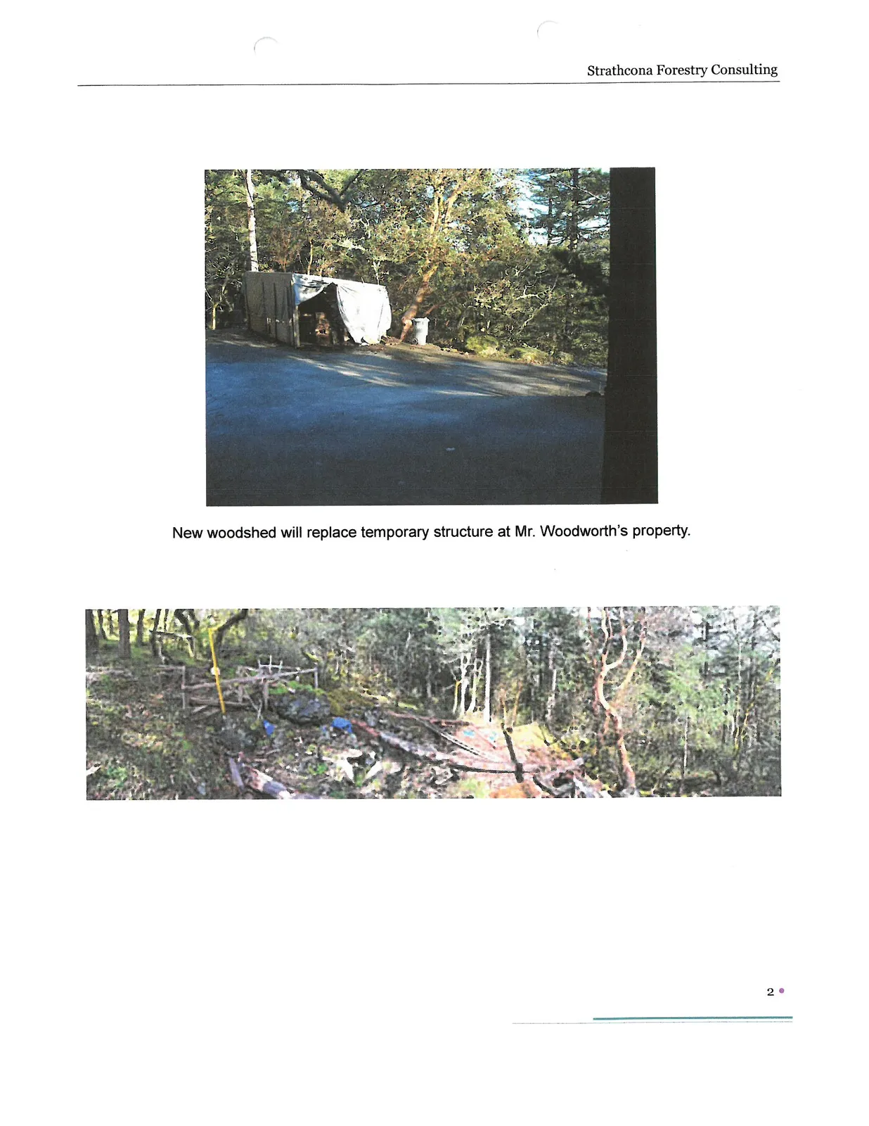
New woodshed will replace temporary structure at Mr. Woodworth’s property.
Discussion
Due to the juxtaposition of Mr. Woodworth’s home and switchback driveway on a moderately steep northeast facing slope, the only suitable location for the woodshed was at the current location. The subject property (including the woodshed) has a moderate to high interface wildfire threat rating.
Mr. Woodworth is aware of the FireSmart program, and has been fully cooperative with vegetation management strategies to reduce wildfire at his property. In 2014, Mr. Woodworth engaged a crew to conduct vegetation management around his home. The crew removed woody fuels in the FireSmart Priority Zone 10-15 m around Mr. Woodworth’s home, and along the upper portion of the driveway right-of-way.
Recommendations
In order to reduce the wildfire threat rating associated with the proposed new woodshed, the following FireSmart recommendations are advised:
Vegetation Management:
- Remove woody debris (trees and shrubs) within the 10 m Priority FireSmart zone around the new woodshed structure.
- Regularly (i.e., annually) implement vegetation management (i.e., clearing away windthrown branches)
Construction:
- Ensure the east (downhill) exterior cladding of new construction is constructed with hardiboard siding or similar rating fire-retardant material
- Construct the roof with metal or other fire-retardant (A, B, or C) rated material
- Install a smoke alarm into the new woodshed
Other:
- As discussed with Mr. Woodworth, ensure hose lengths from outside faucet on home are of sufficient length to reach the woodshed
- Maintain a cache of fire tools (bucket, shovel) on site
Summary
In my professional opinion, if the property owner is compliant with FireSmart strategies, the proposed structure will be safe for the intended purpose, and the interface wildfire threat rating can be maintained at acceptable levels.
Prepared by: Margaret Symon Margaret Symon, RPF. P.C.P. Strathcona Forestry Consulting
Appendix 1. FireSmart Interface Priority Zones
In interface areas, FireSmart advocates the establishment and maintenance of Fuel Management Zones* extending outward from structures and along access routes: Priority Zone 1 (0-10 m). Priority Zone 2 (10-30 m). Priority Zone 3 (30-100 m).
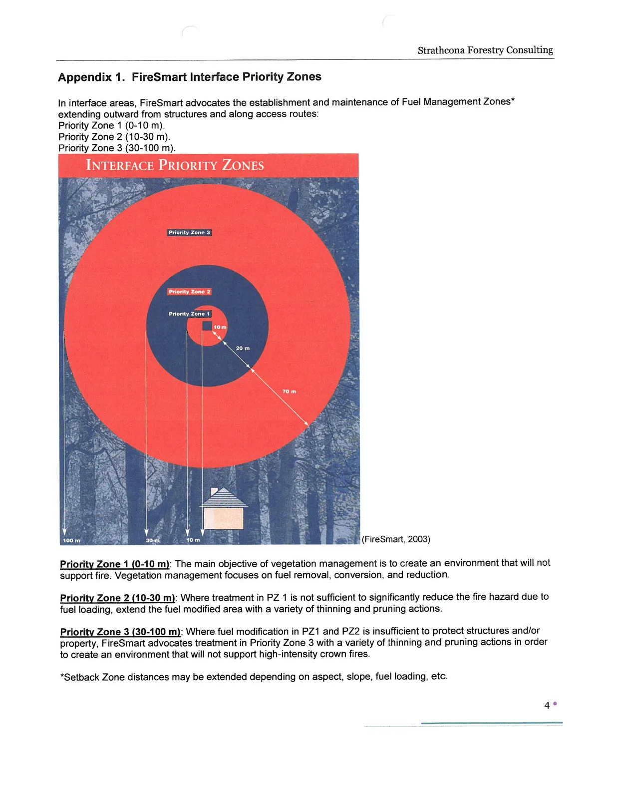
Priority Zone 1 (0-10 m): The main objective of vegetation management is to create an environment that will not support fire. Vegetation management focuses on fuel removal, conversion, and reduction.
Priority Zone 2 (10-30 m): Where treatment in PZ 1 is not sufficient to significantly reduce the fire hazard due to fuel loading, extend the fuel modified area with a variety of thinning and pruning actions.
Priority Zone 3 (30-100 m): Where fuel modification in PZ1 and PZ2 is insufficient to protect structures and/or property, FireSmart advocates treatment in Priority Zone 3 with a variety of thinning and pruning actions in order to create an environment that will not support high-intensity crown fires.
*Setback Zone distances may be extended depending on aspect, slope, fuel loading, etc.
Limitations
This report provides an assessment of WUI hazard and risk. Evaluation is based on professional judgment. The investigation involved a field observation. Recommended treatment pertains only to the particular site as disclosed at the time of inspection. The report was prepared considering site-specific circumstances and conditions. It is intended only for use by the client for the purpose for which it was commissioned and for use by local government regulating the activities to which it pertains.
Document Images
(3)